The NOAA Rapid Update Cycle RUC 1 h
- Slides: 18

The NOAA Rapid Update Cycle (RUC) 1 -h assimilation cycle Stan Benjamin Steve Weygandt John Brown NOAA Forecast Systems Lab – Boulder CO, USA GOAL: • Provide high-frequency (1 h) mesoscale 3 -d analyses and short-range (1 -12+h) forecasts for aviation, severe weather, hydrology, … RUC web site - http: //ruc. fsl. noaa. gov WWRP Symposium -- Nowcasting & Very Short Range Forecasting – 8 Sept 2005 – Toulouse, France

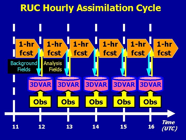
RUC Hourly Assimilation Cycle 1 -hr fcst Background Fields 11 1 -hr fcst 1 -hr fcst Analysis Fields 3 DVAR Obs Obs 12 13 14 3 DVAR Obs 15 Obs 16 Time (UTC)

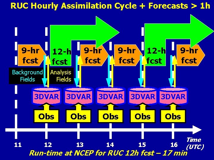
RUC Hourly Assimilation Cycle + Forecasts > 1 h 9 -hr fcst Background Fields 11 9 -hr fcst 12 -h fcst Analysis Fields 3 DVAR Obs Obs 12 13 14 3 DVAR Obs 15 Obs 16 Time (UTC) Run-time at NCEP for RUC 12 h fcst – 17 min

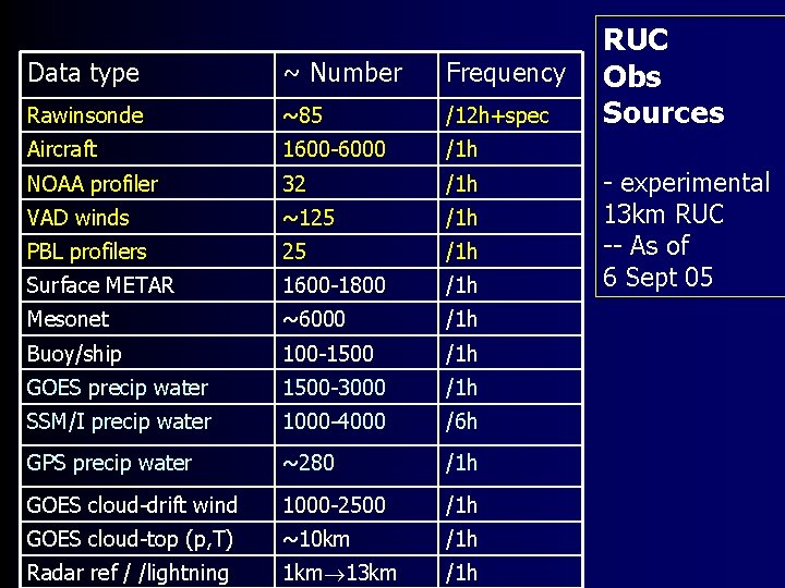
Data type ~ Number Frequency Rawinsonde ~85 /12 h+spec Aircraft 1600 -6000 /1 h NOAA profiler 32 /1 h VAD winds ~125 /1 h PBL profilers 25 /1 h Surface METAR 1600 -1800 /1 h Mesonet ~6000 /1 h Buoy/ship 100 -1500 /1 h GOES precip water 1500 -3000 /1 h SSM/I precip water 1000 -4000 /6 h GPS precip water ~280 /1 h GOES cloud-drift wind 1000 -2500 /1 h GOES cloud-top (p, T) ~10 km /1 h Radar ref / /lightning 1 km 13 km /1 h RUC Obs Sources - experimental 13 km RUC -- As of 6 Sept 05

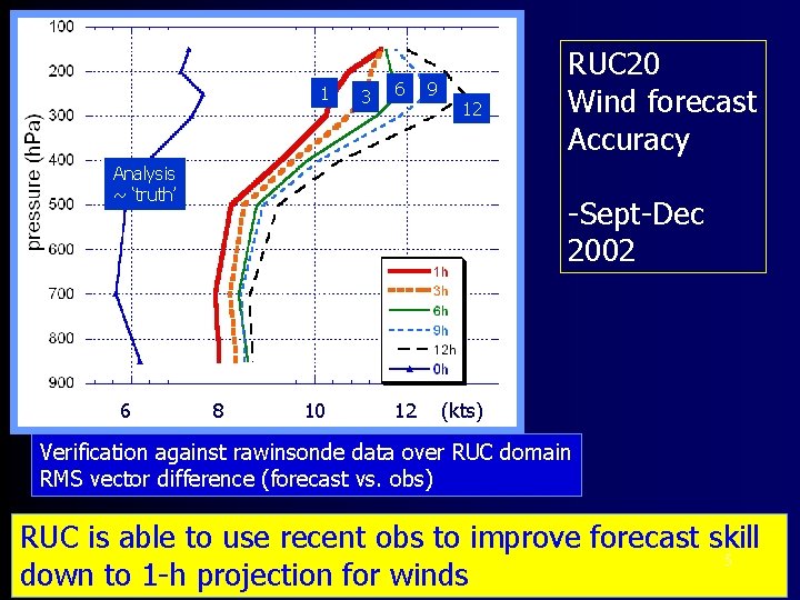
1 3 6 9 12 Analysis ~ ‘truth’ 6 RUC 20 Wind forecast Accuracy -Sept-Dec 2002 8 10 12 (kts) Verification against rawinsonde data over RUC domain RMS vector difference (forecast vs. obs) RUC is able to use recent obs to improve forecast skill 5 down to 1 -h projection for winds

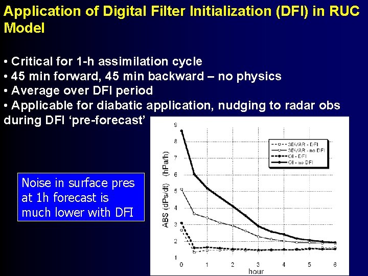
Application of Digital Filter Initialization (DFI) in RUC Model • Critical for 1 -h assimilation cycle • 45 min forward, 45 min backward – no physics • Average over DFI period • Applicable for diabatic application, nudging to radar obs during DFI ‘pre-forecast’ Noise in surface pres at 1 h forecast is much lower with DFI 6

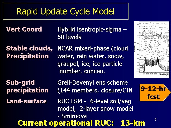
Rapid Update Cycle Model Vert Coord Hybrid isentropic-sigma – 50 levels Stable clouds, NCAR mixed-phase (cloud Precipitation water, rain water, snow, graupel, ice particle number. concen. Sub-grid precipitation Grell-Devenyi ens scheme (144 members, closure/CIN Land-surface RUC LSM - 6 -level soil/veg model, 2 -layer snow model - Smirnova 9 -12 -hr fcst Current operational RUC: 13 -km 7

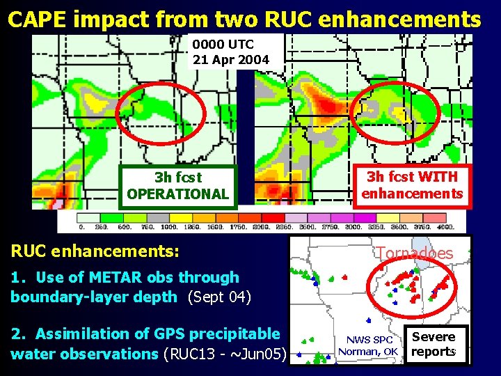
Recent changes to RUC 13 3 DVAR analysis (among many): 1. Use of surface obs throughout PBL (NCEP Fall 2004) 2. Cloud analysis (GOES, METAR ceiling/vis/curr-wx)

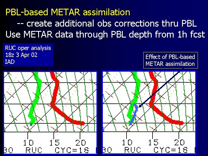
PBL-based METAR assimilation -- create additional obs corrections thru PBL Use METAR data through PBL depth from 1 h fcst RUC oper analysis 18 z 3 Apr 02 IAD Effect of PBL-based METAR assimilation x x 9

CAPE impact from two RUC enhancements 0000 UTC 21 Apr 2004 3 h fcst OPERATIONAL RUC enhancements: 3 h fcst WITH enhancements Tornadoes 1. Use of METAR obs through boundary-layer depth (Sept 04) 2. Assimilation of GPS precipitable water observations (RUC 13 - ~Jun 05) NWS SPC Norman, OK Severe 10 reports

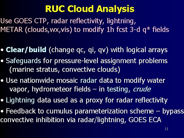
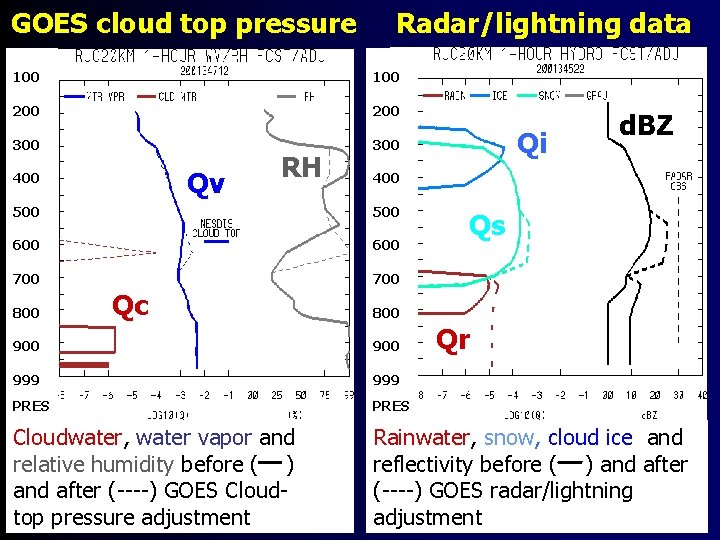
RUC Cloud Analysis Use GOES CTP, radar reflectivity, lightning, METAR (clouds, wx, vis) to modify 1 h fcst 3 -d q* fields • Clear/build (change qc, qi, qv) with logical arrays • Safeguards for pressure-level assignment problems (marine stratus, convective clouds) • Use nationwide mosaic radar data to modify water vapor, hydrometeor fields – in testing, crude • Lightning data used as a proxy for radar reflectivity • Feedback to cumulus parameterization scheme – bypass convective inhibition via radar/lightning, GOES ECA 11

GOES cloud top pressure 100 Radar/lightning data 100 200 300 Qv 400 RH 400 500 600 700 800 Qc Qi d. BZ Qs 800 Qr 900 999 PRES Cloudwater, water vapor and relative humidity before ( ) and after (----) GOES Cloudtop pressure adjustment Rainwater, snow, cloud ice and reflectivity before ( ) and after (----) GOES radar/lightning 12 adjustment

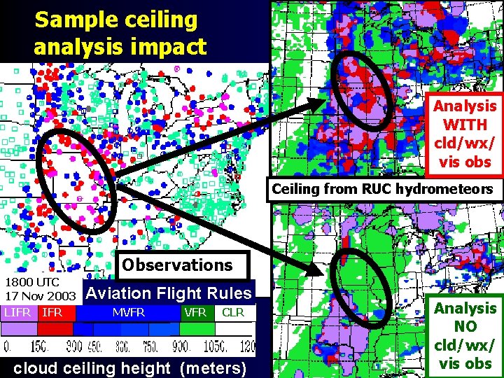
Sample ceiling analysis impact Analysis WITH cld/wx/ vis obs Ceiling from RUC hydrometeors Observations 1800 UTC 17 Nov 2003 LIFR Aviation Flight Rules MVFR CLR cloud ceiling height (meters) Analysis NO cld/wx/ 13 vis obs

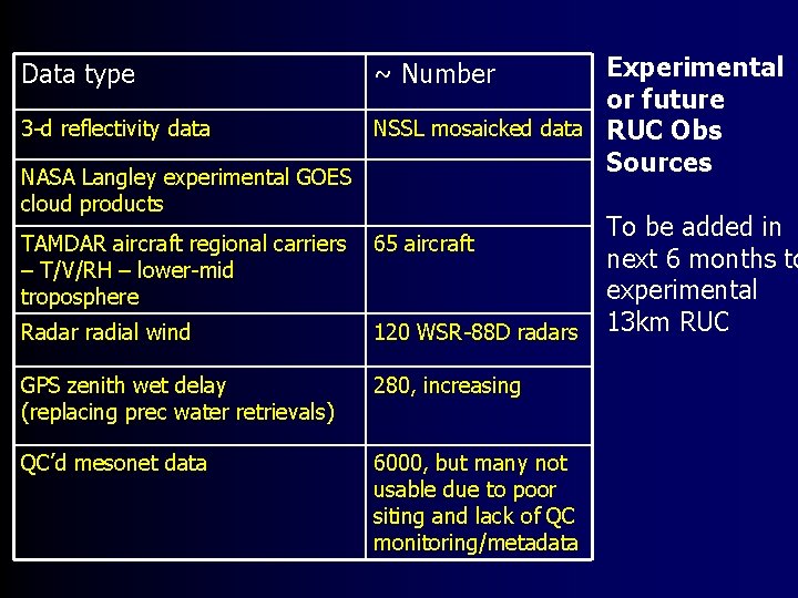
Data type 3 -d reflectivity data NASA Langley experimental GOES cloud products Experimental or future NSSL mosaicked data RUC Obs Sources ~ Number TAMDAR aircraft regional carriers – T/V/RH – lower-mid troposphere 65 aircraft Radar radial wind 120 WSR-88 D radars GPS zenith wet delay (replacing prec water retrievals) 280, increasing QC’d mesonet data 6000, but many not usable due to poor siting and lack of QC monitoring/metadata To be added in next 6 months to experimental 13 km RUC

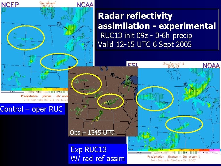
Radar reflectivity assimilation - experimental RUC 13 init 09 z - 3 -6 h precip Valid 12 -15 UTC 6 Sept 2005 Control – oper RUC Obs – 1345 UTC Exp RUC 13 W/ rad ref assim 15

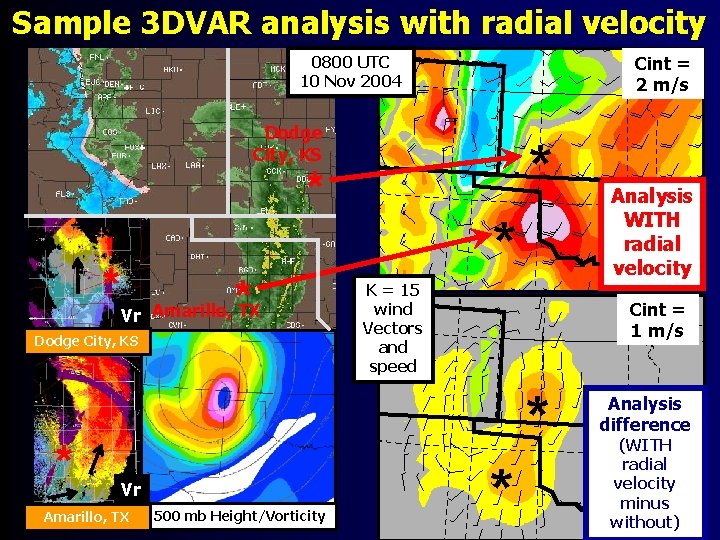
Sample 3 DVAR analysis with radial velocity Cint = 2 m/s 0800 UTC 10 Nov 2004 Dodge City, KS * * * Vr Amarillo, TX Dodge City, KS * * K = 15 wind Vectors and speed Cint = 1 m/s * Vr Amarillo, TX 500 mb Height/Vorticity Analysis WITH radial velocity * Analysis difference (WITH radial velocity minus without)

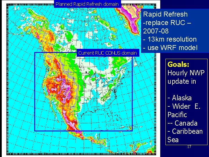
Planned Rapid Refresh domain Current RUC CONUS domain Rapid Refresh -replace RUC – 2007 -08 - 13 km resolution - use WRF model Goals: Hourly NWP update in - Alaska - Wider E. Pacific -- Canada - Caribbean Sea 17

The RUC by 2008, testing in 2006 • “Rapid Refresh” • Simple more complex assimilation of radar reflectivity and radial winds • Improved use of sat data, GPS, aircraft, surface/mesonet • Use of WRF model w/ RUC-like physics • Use of NCEP data assimilation (GSI) with RUC-specific enhancements – use of sfc data, cloud analysis • North American coverage 18