The National Pipeline Mapping System NPMS Amy Nelson
 Amy Nelson GIS Manager US Department of Transportation")


 www. npms. phmsa. dot. gov")


- Slides: 17
The National Pipeline Mapping System (NPMS) Amy Nelson GIS Manager US Department of Transportation Pipeline and Hazardous Materials Safety Administration (USDOT PHMSA)
What is the NPMS? • A GIS dataset containing liquid and gas transmission pipelines and LNG facilities in the United States • Created by USDOT PHMSA • A GIS-enabled Web site is at www. npms. phmsa. dot. gov • Only complete non-commercial source of transmission pipeline GIS data
Data Collection and Maintenance • Data collected from transmission pipeline operators • Submission is mandatory; submissions updated each year • Acceptable formats include GPS coordinates, CAD files, ESRI shapefiles • Data processed and maintained by contractor Michael Baker
Two Ways to View Pipeline Maps • PIMMA ° Password required ° Access limited to Federal government, state/local government, pipeline operators ° Contractors may use their client’s login information if an NDA is signed (client must apply for the account) ° Contains most detailed information ° Allow one week for processing, plus mail time • Public Viewer ° ° Newly launched Open to everyone View only one county per session Limited information and detail
View data without username/password Apply for a username/password
NPMS Public Viewer No password required
NPMS Public Viewer Maximum zoom extent is shown
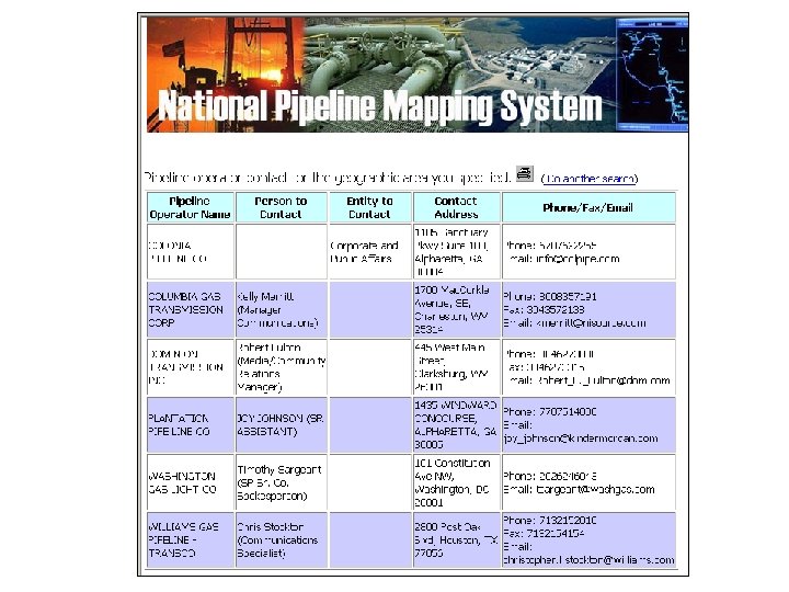
View public contact information
Contacting a Pipeline Operator • General public may view list of transmission pipeline operators in their area • Tabular data contains a name or entity, and phone number or email
PIMMA (Password required) www. npms. phmsa. dot. gov
PIMMA with USGS aerial photos
Obtaining Raw Data • Available to Federal/state/local government officials and pipeline operators • Data delivered on CD in ESRI shapefile format • Allow one week for processing, plus mail service • Data cannot be shared or disseminated, except internally in your agency ° Exception: county/local governments (contact Amy. Nelson@dot. gov for details)
Ask for raw data on CD
Data Attributes include • Operator name • Pipeline system name • Commodity carried • Diameter (optional but reported for 78% of records) • Interstate/ intrastate designation • Data accuracy Not all attributes are available on the Public Viewer
Data Accuracy 501 -1000 feet Unknown 2% 2% 0 -50 feet 22% 301 -500 feet 29% 51 -300 feet 45% Standard is +/- 500 feet
Questions? Amy Nelson GIS Manager 202 -493 -0591 Amy. Nelson@dot. gov