The Knowledge Discoverer Module in Arc SIE A

 is a module in Arc. SIE for soil survey update. •")


 from the existing map.")
 from the existing map • Find out the frequencies")
 from the existing map")
 from the existing map.")


 from the existing map.")


- Slides: 26
The Knowledge Discoverer Module in Arc. SIE: A Software Tool for Soil Survey Update Xun Shi 1, Jessica Philippe 2, Robert Long 2, and Tom D’Avello 3 1 SIE LLC and Dartmouth College 2 USDA-NRCS, St. Johnsbury, VT 3 USDA-NRCS, NSSC-GRU, Morgantown, WV
Knowledge Discoverer (KD) is a module in Arc. SIE for soil survey update. • Arc. SIE is a software package designed for NRCS soil scientists to use in their daily soil mapping practice. • Arc. SIE works as an extension of Arc. Map. • Arc. SIE can be downloaded from www. arcsie. com
www. arcsie. com
Reasons for soil survey update • We have better environmental data now. New types of data and new information Better data: high resolution and/or accuracy
Reasons for soil survey update • We have better environmental data now. • We have better knowledge now. New soil ty p es soil t u o b a n rmatio o f n i w e N operties r p New kno wledge ab optimal s out lope for t he soil to e th t ou ab e dg le ow o kn ccur New relationship between soil and wetness index New or improved knowledge Better ways to express and represent the knowledge
Reasons for soil survey update • We have better environmental data now. • We have better knowledge now. • Inconsistency between different regions. Spatial mismatch Attribute mismatch
The Knowledge Discoverer Approach The approach is to discover, revise, and reuse the knowledge (soil-landscape model) implicitly represented by an existing soil map, during which it incorporates updated (better) knowledge and data.
A 3 -step Process • Extracting the knowledge (soil-landscape models) from the existing map.
Extracting the knowledge (soil-landscape models) from the existing map • Find out the frequencies of different values of an environmental factor within a map unit polygon. • Use the frequencies to construct a math function characterizing the soilfactor relationship, represented by a curve. 769 770 771 771 772 773 769 770 771 771 771 772 772 772 770 770 771 771 772 772 772 770 770 771 771 771 771 772 773 770 771 771 771 772 772 773 774 776 771 771 772 773 773 774 775 776 778 781 772 772 773 774 775 776 777 779 781 783 785 772 773 774 775 777 778 779 781 784 786 788 771 771 772 773 774 776 778 779 782 786 789 792 796 769 770 771 772 775 778 781 785 791 795 800 804 810 768 769 771 774 778 783 789 796 803 809 814 819 824 768 769 771 774 778 784 791 800 808 815 822 828 833 839 769 770 773 777 783 791 801 811 829 836 842 847 853 770 772 775 781 789 799 811 823 834 843 850 855 860 866
Extracting the knowledge (soil-landscape models) from the existing map
A 3 -step Process • Extracting the knowledge (soil-landscape models) from the existing map. • Revising the extracted soil-landscape model.
Revising the extracted soil-landscape model. Change the shape of the curve
Revising the extracted soil-landscape model. Integrate multiple curves
Revising the extracted soil-landscape model. Corresponding a curve to its polygon in the map
Revising the extracted soil-landscape model. Statistics of the raster cell values
Revising the extracted soil-landscape model. Export the revised curve into a rulebase
User Interface of the Knowledge Discoverer Environmental Factor List Vector Feature List Rule Curve Editor Statistics Display Panel Generated Rulebase
A 3 -step Process • Extracting the knowledge (soil-landscape models) from the existing map. • Revising the extracted soil-landscape model. • Regenerating the soil map using the new model and new data.
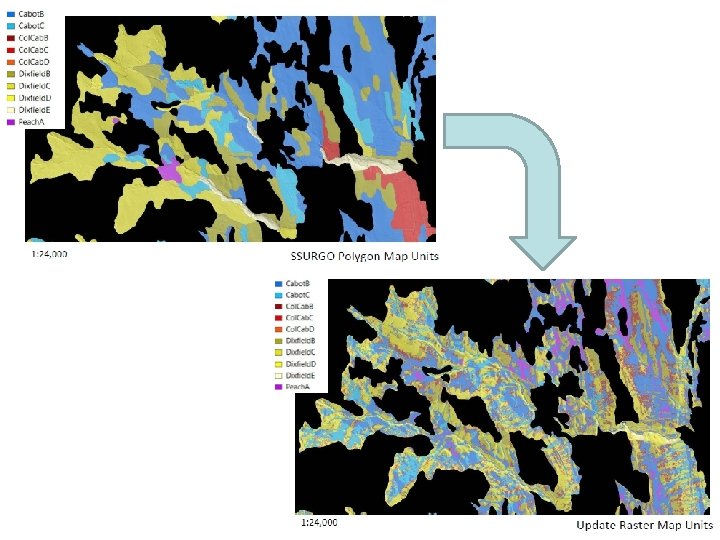
Regenerating the soil map using the new model and new data Use Arc. SIE’s Inference Engine to generate the updated map with the new soil-landscape model and new data
A Case Study • The western section of the Orleans County, Vermont. • An area the soil scientists were somewhat familiar with. • Was mapped using the traditional method. • Has recent Li. DAR data available. • Was further subset into just the lodgment till map units, for testing the Knowledge Discoverer on a catena.
Knowledge Discoverer Original SSURGO polygon of Dixfield sandy loam, 8 -15 percent slope One “typical” curve was selected to represent each map unit, and edited according to new knowledge/better data (in this case Li. DAR derivatives) Soil Inference Engine Updated map
Summary • KD takes advantage of the knowledge in the existing map. • KD takes advantage of new/better environmental data generated with modern technologies (e. g. , Li. DAR). • KD incorporates new/better knowledge of current soil scientists. • KD creates updated maps that meet the modern digital soil mapping standards. After all, these form the whole point of doing map update.
Some things to consider • This process is not starting from scratch and is not traditional soil mapping. It assumes that the SSURGO mapping is correct at some level (specifically, that the mapped parent materials are generally correct). • The resulting updated map is a raster map, and a separate product from the SSURGO polygons. The results are not expected to fit within SSURGO constraints. • It is recommended to undertake an MLRA-wide update project is by grouping map units into different catena. On the one hand, data and conceptual limitations make it difficult to update the entire area at once; on the other hand, updating just one map unit in a vacuum is not productive. Catena allows evaluating and adjusting a number of map units that are related to each other together.
For more information about the usage of Knowledge Discoverer, please download Arc. SIE User’s Manual from www. arcsie. com.
Acknowledgement: The development of Arc. SIE has been supported by contracts from USDA-NRCS since 2005. Thank you!