The Joint Hurricane Testbed and the Visiting Scientist

The Joint Hurricane Testbed and the Visiting Scientist Program at the National Hurricane Center 8 December, 2008 Chris Landsea National Hurricane Center, Miami

The Joint Hurricane Testbed

Joint Hurricane Testbed JHT – Why is it needed? l Transition process l What has been accomplished l What projects are being tested currently l What is in process for FY 09 (and beyond) l Who is involved with the JHT… l
: How to The Researchers (them): bridge the “valley of death”?")
The Forecasters (us): How to The Researchers (them): bridge the “valley of death”?

JHT Mission Statement The mission of the Joint Hurricane Test Bed is to transfer more rapidly and smoothly new technology, research results, and observational advances of the United States Weather Research, its sponsoring agencies, the academic community and other groups into improved tropical cyclone analysis and prediction at operational centers.

JHT Process • Principal Investigators apply for funding through NOAA • A seven member Steering Committee rates all proposals • Funded projects are tested during one or two hurricane seasons in conjunction with NHC/ Environmental Modeling Center points of contact • At the project’s end, each are evaluated by NHC/EMC staff • Implementation of successful projects are then carried out by NHC/EMC staff/PIs
 –")
What Have We Accomplished - 2001 -2008 • Projects supported (rounds 1 -4) – 50 – Projects ongoing (round 4) - 10 – Projects completed (rounds 1 -3) – 40 • Completed projects not accepted – 5 • Completed projects pending further evaluation – 5 • Projects accepted for implementation – 30 – Projects accepted, not fully implemented – 3. 5 – Projects implemented (NHC/EMC/NCO) – 26. 5 Dedicated NHC, EMC & JHT staff, and close collaborations between the PIs, points-of-contact and support staff is the key.

2008 Major Activities • Completion of the third round projects – Principal Investigators provide final report Aug 2007 – Final evaluation (NHC/EMC POCs & JHT) – Sep-Dec 2007 – Decision on acceptance for implementation (NHC and EMC Directors) – Jan 2008 • 4 criteria for acceptance • 12 projects accepted • 3 projects deferred pending further evaluation – Implementaton – Jan-Jul 2008 • 11 implemented: 4 by EMC/NCO & 7 by NHC

Factors Considered in NHC Decisions on Operational Implementation • Forecast or Analysis Benefit: expected improvement in operational forecast and/or analysis accuracy • Efficiency: adherence to forecaster time constraints and ease of use needs • Compatibility: IT compatibility with operational hardware, software, data, communications, etc. • Sustainability: availability of resources to operate, upgrade, and/or provide support
 • Some relative easy • Some very complicated • NHC contributes ≥")
Implementation (NHC) • Some relative easy • Some very complicated • NHC contributes ≥ 0. 5 FTE on implementation • JHT IT facilitator assists in the process • NCEP/EMC and NCO also contributed Operational Centers are not funded for this task

Highlights of 3 rd Round Implemented Projects Topographic Wind Effects - Miller VORTRAC – Lee/Bell/Harasti OLD GFDL (2) NEW GFDL (4) OLD GFS (1) NEW GFS (3) GFDL – Bender HWRF – Tuleya, Powell

Highlights of 3 rd Round Implemented Projects Inclusion of Dropsonde Moisture into GFS – Aberson/Dunion Revised SHIPS intensity forecast scheme – De. Maria/Knaff Wind Radii Decay Model - Kaplan Corrected Consensus Track Forecasts Goerss

Highlights of 3 rd Round Implemented Projects Improvements to ATCF operating system - Sampson Enhancements to Wind Probability Wind Radii Decay Model - Kaplan Products – Knaff/De. Maria SFMR - Carswell/Black

Sea state under Hurricane Isabel Breaking waves Wind-blown streaks

Stepped-Frequency Microwave Radiometer • Measures nadir brightness temperature at 6 C-band frequencies. • Geophysical model function relates emissivity to wind speed. Emissivity depends on surface foam coverage and rain rate. • Calibrated with GPS dropsonde data. • First data from C-130 s in 2007.

Air Force 29 Aug 0930 UTC NOAA SFMR 29 Aug 0930 UTC

C 130 s Now Equipped with SFMR Thanks to: HRD, AOC, RSS, NESDIS, Pro. Sensing, CARCAH, AF 53 rd Reconn. Squad. Air Force 29 Aug 0930 UTC

2008 Major Activities Cont. • Second year funding renewal for 4 th round projects – Mar 2008 • Testing of 4 th round projects – Jun-Nov 2008 – Collaboration with PI – Programming – Establishing data flow – Generating output forecaster use/evaluation

4 th Round Project Focus Areas Primary Area of Focus # of Projects Improvements to dynamical models (for track, intensity, and precipitation forecasts) 5 Statistical intensity forecast guidance 1 Tropical cyclone structure/wind/wave distribution Track forecast guidance Enhancements to operational environment Total 2 1 1 10
 Projects Intensity, structure, and track projects Proposal Title")
JHT Fourth Round (FY 07 -08) Projects Intensity, structure, and track projects Proposal Title PI TPC POC Improving the Hurricane WRF-Ocean Coupled System for Transition to Operations (model) Ginis, Isaac (Univ. of Rhode Island) Pasch, Cangialosi, Lozano/Tolman (EMC) An Improved Wind Probability Estimation Program (algorithm) Stan Kidder (CSU), De. Maria, Mark (NESDIS) Harr, Pat (NPS) Lauer, Brennan, Knabb (PHFO/CPHC) Hurricane Model Transitions to Operations at NCEP/EMC (model) Tuleya, Bob (SAIC) Pasch, Fiorino, Rhome, Surgi (EMC) Web-ATCF, user Requirements and Intensity Consensus (application) Sampson, Charles (NRL) Franklin, Sisko Evaluation and Improvement of Ocean Model Parameterizations for NCEP Operations (algorithm) Shay, Nick (UM) Avila, Rhome, Lozano(EMC)
 Projects Intensity, structure, and track projects Proposal Title")
JHT Fourth Round (FY 07 -08) Projects Intensity, structure, and track projects Proposal Title PI TPC POC Operational Use of Near-Real Time Surface Directional Wave Spectra Generated from NOAA Scanning Radar Altimeter Range Measurements Walsh, Edward (NASA/GFSC) Beven, Brown, Rhome, Cobb High Wind Drag Coefficient and Sea Surface Roughness in Shallow Water Powell, Mark (1 yr) (AOML) Franklin, Blake, Tolman (EMC) Validation and Processing Tools for the AF Reserves Command 53 rd Weather Reconnaissance Squadron WC-130 J Multi-Aircraft SFMR Systems J. Carswell (RSS, Inc. ) P. Black (AOML) Beven, Brown, Sisko, Christensen Evaluation and Improvement of Spray-Modified Air-Sea Enthalpy and Momentum Flux Parameterizations for operational Hurricane Prediction J. Bao, C. Fairall, J. Wilczak (ESRL) Pasch, Berg, Fiorino, Surgi/Kwon (EMC) TC Dressing: A Probabilistic Approach to Providing State Dependent, Non-Isotropic Forecast Track Error Guidance J. Hansen J. Goerss (NRL) Franklin, Blake, Sisko
 Funding Distribution Total $1. 03 M NOAA 19% State/Private")
4 th Round (FY 08) Funding Distribution Total $1. 03 M NOAA 19% State/Private Universities 32% Navy (NPS, NRL) 15% NASA 11% Private Companies 23%

2008 Major Activities • Cont. Preparing for 5 th round projects – Draft Federal Funding Opportunity - Mar 2008 • • – – Centers priorities Evaluation criteria Publishing FFO (Jul 2008) Review of Pre-applications (Sep 2008) PIs submitting full proposals (Oct 2008) Review of full proposals (ongoing)

Challenges for FY 09 • Fifth round funding processes – – – Steering committee review proposals Rank and select proposals for funding Work with Grants Office to fund selected projects Find Point of contacts among NHC forecasters and support staff Work with PIs to setup timelines for their projects • Test and evaluation – Prepare real-time testing & evaluation for 4 th and 5 th round projects • Manage 4 th & 5 th round projects – – Progress reports Final reports for 4 th round projects POC feedback JHT final review/reports • Implementation of newly accepted 4 th projects (NHC) (FY 10)

What does it take to support the JHT? JHT Staff: 1. Jiann-Gwo Jiing (JHT Director) 2. Jose Salazar (JHT IT specialist) 3. Shirley Murillo (JHT Admin. Asst. ) 4. Chris Landsea (JHT Admin. Asst. ) JHT Steering Committee: 1. Ed Rappaport (NHC – Co-chair) 2. John Gamache (Hurricane Research Division – Co-chari) 3. Jeff Hawkins (Naval Research Laboratory) 4. Naomi Surgi (Environmental Modeling Center) 5. Ed Fukada (Joint Typhoon Warning Center) 6. Hugh Willoughby (Florida International U) 7. Liz Ritchie (U Arizona) JHT principal investigators and other funded participants John Gaynor (US Weather Research Program) NHC and EMC forecasters and technical points of contacts NHC/Technical Support Branch IT staff

The Visiting Scientist Program

NHC Visiting Scientist Program l l l l 2007 Hurricane Research Division “Shadowing” Hurricane Forecast Improvement Program & NCEP’s Strategic Plan NHC Visiting Scientist Guidelines 2008 VSP Participants 2008 VSP Presentations Visiting Scientist Feedback Hurricane Specialists Feedback Possible Changes for 2009

2007 HRD Shadowing Program l l In 2007, seven HRD researchers “shadowed” the Hurricane Specialists during swing shifts Goals were to: 1) facilitate better understanding by HRD researchers of the NHC hurricane forecasting process including the tools and techniques used by the Hurricane Specialists; 2) open additional dialog between NHC-HRD that could lead to improvements in NHC’s analysis and prediction methodologies HRD participants unanimously thought the program to be extremely beneficial NHC Hurricane Specialists feedback was primarily favorable with several comments for improvements

Hurricane Forecast Improvement Project & NCEP Strategic Plan l l Spring of 2008, HFIP plan developed which included: “to support research and technology development and training activities for external community at NOAA operational facilities (e. g. , visiting scientists, Post. Docs, graduate students, professors) Also Spring of 2008, NCEP Strategic Plan included: “expand the visiting scientist program at NCEP to leverage from the external community”

Goals for the NHC Visiting Scientist Program l To facilitate better understanding by researchers/outside forecasters of the NHC hurricane forecasting process including the tools and techniques utilized by the Hurricane Specialists; l To open additional dialog between NHC and the research/outside forecast community that could lead to improvements in our analysis predictions methodologies

2008 Guidelines for Visiting Scientist Program l l Program restricted to scientists that have interest/expertise in day-to-day hurricane forecasting operations VS shadows the Hurricane Specialists during the swing shift l l l l l 7 -7: 30 pm: Digest new model guidance 7: 30 -8 pm: Prepare Tropical Weather Outlooks (and graphics) 8 -9 pm: Analyze the tropical cyclone (position, intensity, size, structure) 8: 30 pm: Receive Tropical Analysis and Forecast Branch and Satellite Analysis Branch Dvorak analyses 9 pm: Initialize guidance 9 -10 pm: Generate track, intensity, size, and structure forecasts 10 pm: Conference call (for Atlantic tropical cyclones) 10 -11 pm: Refine analyses and forecasts; write Public Advisory and Discussion 11 pm: Release Advisory package and produce graphics

2008 Guidelines for Visiting Scientist Program l l l l Program restricted to scientists that have interest/expertise in day-to-day hurricane forecasting operations VS shadows the Hurricane Specialists during the swing shift from 7 -11 pm 11 VS participated with representatives from WFOs, government labs, academia, and other forecasting centers Each VS would participate for one to five days Scheduled developed for participants from July to October peak of the season If a major hurricane threatened the US, the shadowing would be postponed/canceled If there were no active tropical cyclones, the shadowing could be postponed VS would not be performing any operational duties

2008 Guidelines for Visiting Scientist Program l l VS encouraged to bring laptop to connect to wireless internet connection in event of significant down time VS offered to spend time with our Tropical Analysis and Forecast Branch VS given opportunity to give a seminar on topic of their choosing No funding was available to assist scientists for their visit

2008 Participants l l 30 researchers/outside forecasters asked to participate Jamie Rhome (then Hurricane Specialist), Robbie Berg (then TAFB Forecaster), and I selected the 11 participants to maximize the variety of groups represented: l l l l • Hurricane Research Division (Shirley Murillo, Sim Aberson) Naval Research Laboratory (Jim Hansen) University professor (Bob Houze – U Washington) University grad student (Kevin Talgo – NCSU, Jon Moskaitis – MIT) Weather Forecast Offices (Andy Devanas – Key West, Robert Bright – Charleston, Erik Pytlak – Tucson) Cooperative Institute for Research in the Atmosphere (Andrea Schumacher) Canadian Hurricane Center (Chris Fogarty)

2008 Presentations l l l Bob Houze - "Convective Contribution to the Genesis of Hurricane Ophelia (2005)" Jim Hansen - "Advances in tropical cyclone track uncertainty guidance: Understanding why uncertainty looks the way it does" Jon Moskaitis - "Verification of deterministic TC intensity forecasts: Beyond summary accuracy measures" Andrea Schumacher – "Hurricane research in the Rockies: An overview of recent research to operations activities at CIRA" Erik Pytlak - "Northeast Pacific Tropical Cyclones in the Southwest US - Climatology, Impacts and Forecasting” Chris Fogarty - "Canadian Hurricane Centre - Ongoing Operational and Development Activities"

Visiting Scientist Comments l “The NHC Visiting Scientist Program was a fantastic experience. In my view there is no way a research scientist can understand the operational problem unless he/she spends time in an operational environment observing and asking questions. The NHC employees were all very generous with their time and insights and lessons learned during the trip have already modified my research agenda. ” l “As a graduate student in the field of tropical meteorology, it was an excellent learning experience for myself and also of great benefit to the NC State meteorology department…It was fascinating to witness first-hand the challenges and pressure encountered by forecasters when a tropical cyclone is bearing down on the U. S. coast. “ l “I learned a lot more about NHC and TAFB products and services, the research NHC and universities are conducting on ET transitions, and the delicate workload balance NHC forecasters have to juggle when systems are affecting both the Atlantic and East Pacific. ”

Hurricane Specialists Comments l “I'd say the NHC Visiting Scientist Program has been hugely successful. I have enjoyed interacting with each of the guests, and I have found them to be very attentive and enthusiastic about NHC operations and programs. Any exchange of information is good, especially when it comes to our users acquiring a better understanding of our operations and products. ” l “Overall, the interactions were positive and I believe that the individuals gained knowledge of the forecast process during the visit…I think we should try to focus much of this program on WFO personnel as this would certainly improve coordinate between NHC and WFOs and could assist in the development and implementation of the proposed collaborative NWS TC watches and warnings. ”

Possible Changes for 2009 l l l More formal interaction designed specifically with TAFB Make available opportunity to visit WFO Miami/ HRD/UMiami/FIU in situations with no tropical cyclone activity Provide funding from NCEP SOO pot-o-money for WFO participation Include participation from other national centers and River Forecast Centers Provide more NHC background information for VS participants Guarantee that there will be an active tropical cyclone during the VS stay…

Visiting Scientist Program Scenes from NHC, TAFB, Miami WFO and AOML/HRD

The Joint Hurricane Testbed and the Visiting Scientist Program at the National Hurricane Center 8 December, 2008 Chris Landsea National Hurricane Center, Miami

NHC Contributions to JHT Logistics • Dedicated physical space in operations, offices Personnel • NHC dedicating about 1. 5 FTE spread across ~12 people – 0. 5 FTE reimbursed by USWRP for quarter-time JHT Director and one quarter-time JHT administrative assistant – NHC contributing 1. 0 FTE, including TPC member on JHT Steering Committee, forecasters, and technical support staff • Forecaster and technical points of contact (POC) • Programming, system administration, and network support • Administrative support Computing Resources • Network connectivity • Operational data flow
 • 7 -member Steering Committee –")
JHT Infrastructure Personnel • Quarter-time Director (NOAA FTE) • 7 -member Steering Committee – Three from NOAA (one TPC), two from DOD, and two from the academic community – TPC member serves as co-Chair • Two quarter-time administrative assistants (NOAA FTE) • One IT Facilitator (meteorologist/programmer) Computing Resources • Server and workstations • Software
 Inner Core SSTs (Cione)")
JHT 2 nd Round Implemented Projects Track Uncertainty Estimates (Goerss) Inner Core SSTs (Cione) Rain-CLIPER & rainfall verification (Rogers) Doppler Winds (Gamache) GFDL/URI Hurricane Model upgrades (Bender; Ginis) SHIPS & Wind Probabilities (De. Maria/Knaff) Genesis forecasting assessments (Harr)

JHT 2 nd Round Projects - Implemented Hurricane Spiral Analysis Isabel Advanced Objective 16 Sept 2003 00: 15 UTC Ring Analysis Dvorak Technique (Kossin/Velden) Combo Analysis Ocean Modeling (Jacob) HYCOM Ocean Model Hurricane-Weather Research Forecasting Model (Tuleya) Targeted Observations (Majumdar/Aberson) Rapid Intensification Index (Kaplan) 5 day Climatology. Persistence Model (Aberson)

Hurricane Weather Research and Forecasting Model Naomi Surgi HWRF Program Leader NCEP/Environmental Modeling Center WHERE AMERICA’S CLIMATE AND WEATHER SERVICES BEGIN
, I.")
HWRF TEAM Qingfu Liu, Veejay T, Y. Kwon, R. Tuleya, B. O’Connor (EMC), I. Ginis, Biju (URI), M. Powell (NOAA/HRD), C. Liou (NRL), J. Bao, C. Fairall, S. Michelson (NOAA/ESRL)

THE HWRF SYSTEM 2007 Movable, 2 - way nested grid (9 km; 27 km/42 L; ~75 X 75) Advanced Physics (atm/ocean BL; tested in GFDL – the “benchmark”) Advanced vortex initialization - uses GSI 3 D var (advancement over GFDL bogus) – assimilation of doppler radar data to run in development parallel POM ocean (w/loop current init – same as GFDL) WAVEWATCH III – static multi-grid nesting

ATL Track Error ‘ 04, ‘ 05, ‘ 06 Avg. Some degradation at 120 hr mostly from ’ 04
 TRACKS")
HWRF GFDL KATRINA (2005) TRACKS

Intensity Error ’ 04, ’ 05, ‘ 06 Avg.

‘ 08 Implementation • Begin to assimilate P-3 radar obs in 3 Dvar to initialize hurricane core • Couple to HYCOM (including data assimilation for ocean obs, e. g. AXBT’s) • Upgrade surface fluxes w/sea spray parameterization (collaboration with URI and Boulder lab) • Couple to ocean in EPAC • Couple to WAVEWATCH III (important for improved sfc. fluxes). Also, WAVEWATCH advancement in movable, multi grid around hurricane

Advancing HURRICANE WRF System 08 09 10 11 Mesoscale Data Assimilation for Hurricane Core Radial velocities Advance reflectivity 12 4 DVAR Atm. Model physics and resolution upgrades (continuous) Atm/ocean boundary layer: wave drag, enthalpy fluxes (sea spray) Microphysics, radiation Incr. Res: 4 -6 km. ? . HWRF Ensembles? Land surface Coupling Waves: multi-grid/surf-zone physics Ocean: 4 km. - continuous upgrades in Ocean Data Assimilation

New Tropical Cyclone Wind Speed Probability Products from NHC Richard Knabb, Chris Landsea, Edward Rappaport, Michelle Mainelli, Chris Lauer, Alison Krautkramer, James Franklin, and Jamie Rhome National Hurricane Center Scott Kiser and Tim Schott - NWS Headquarters Mark De. Maria – NESDIS and John Knaff - CIRA

JHT Website www. nhc. noaa. gov/jht/index. shtml
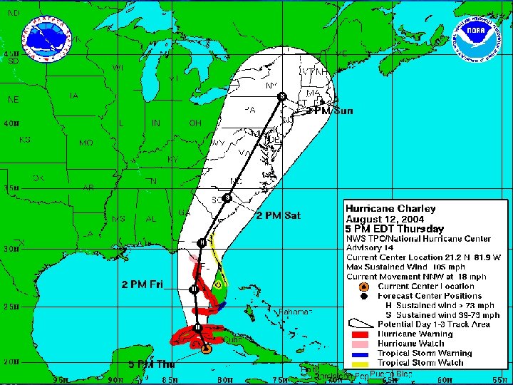

5 -day cumulative probabilities of hurricane-force winds Note that chances of hurricane-force winds at Tampa Bay and Port Charlotte are both around 30%! Hurricane Charley (2004) Advisory #14, 5 pm August 12

What do the new probability products tell you? Answers to two main questions: What are the chances this event is going to happen to me? • Do I need to prepare? • Cumulative period probabilities • New graphics and text products from NHC and CPHC When is the event most likely to start at my location? • How much time do I have left to prepare? • Individual period probabilities • New text products from NHC and CPHC

NHC Website Probability Graphics 34 kt example

NHC Website Probability Graphics 34 kt example
")
NHC Website Probability Graphics 34 kt example TS Alberto (2006)

Small probabilities of an extreme event still warrant taking precautions

- Slides: 65