The illusion of Storm Based Warnings Daryl Herzmann

The illusion of Storm Based Warnings Daryl Herzmann Iowa State University

Don’t agree with something you see? Do what this guy did! I’ll act indignant and ignore you.

Why am I so bitter? 1. Old Age 2. The calendar says 2011, our NWS is stuck in 1970 s technology (ASCII Text) 3. Too many warnings are issued. Do you know how many? 4. I got married last July!

NWS County SVR/TOR Warnings Storm Based Warnings Total Size Count 20 80, 000 70, 000 NEXRAD 60, 000 50, 000 15 40, 000 10 30, 000 20, 000 5 0 10, 000 1986198819901992199419961998200020022004200620082010 0 Total Number of Warnings Total Area [x CONUS] 25

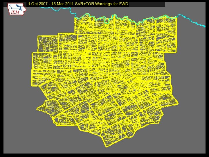
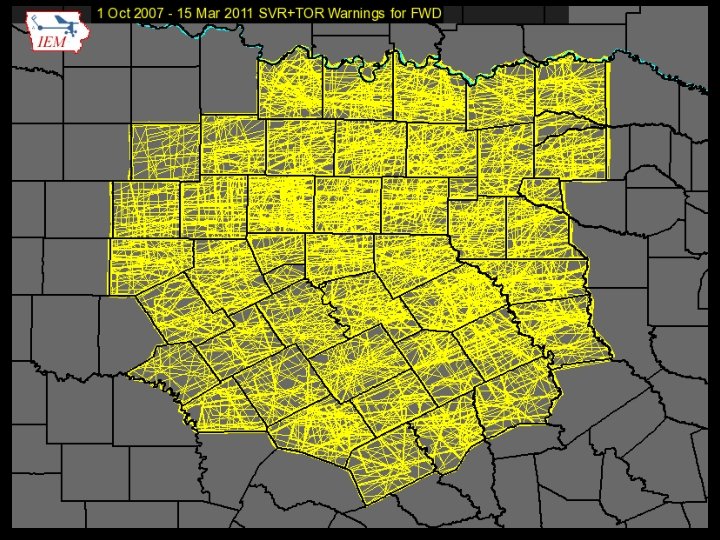
1 Oct 2007, warnings changed http: //www. weather. gov/sbwarnings “Storm-Based / Warnings show the specific meteorological or hydrological threat area and are not restricted to geopolitical boundaries. ”

Warning Process Evaluation Garden Variety Tornado We had better warn.

Warning Process Evaluation Yippee, we can use our fine education and draw a polygon!

Warning Process Evaluation I draw my fancy pants polygon out for 30 minutes. I’m done, right?

daryl’s here Warning Process Evaluation Gasp, I’m warning for 5 counties! Sirens will go off In all 5!

daryl’s stays asleep Warning Process Evaluation Warn. Gen clipping to the rescue!

Warning Process Evaluation Whoa, what happened?
")
These aren’t the polygons you’re looking for (Maryland == 26, 000 sq km)

Ye ole text product You can’t read this, nor can the public! 291 WUUS 53 KDMX 182302 SVRDMX IAC 007 -117 -125 -135 -181 -182345/O. NEW. KDMX. SV. W. 0171. 100618 T 2302 Z-100618 T 2345 Z/ BULLETIN - IMMEDIATE BROADCAST REQUESTED SEVERE THUNDERSTORM WARNING NATIONAL WEATHER SERVICE DES MOINES IA 602 PM CDT FRI JUN 18 2010 PRECAUTIONARY/PREPAREDNESS ACTIONS. . . MOVE TO AN INTERIOR ROOM AND STAY AWAY FROM WINDOWS. IF YOU ARE IN A MOBILE HOME. . . GET OUT NOW. . . AND SEEK SHELTER IN A REINFORCED BUILDING. A TORNADO WATCH REMAINS IN EFFECT FOR THE WARNED AREA. SEVERE THUNDERSTORMS CAN PRODUCE TORNADOES WITH LITTLE OR NO THE NATIONAL WEATHER SERVICE IN DES MOINES HAS ISSUED A WARNING. IF A TORNADO IS SPOTTED. . . IMMEDIATELY MOVE TO THE BASEMENT OR SMALL * SEVERE THUNDERSTORM WARNING FOR. . . NORTHWESTERN APPANOOSE COUNTY IN SOUTH CENTRAL IOWA. . . INTERIOR ROOM OF A REINFORCED BUILDING. NORTHEASTERN LUCAS COUNTY IN SOUTH CENTRAL IOWA. . . SOUTHWESTERN MARION COUNTY IN SOUTH CENTRAL IOWA. . . TORRENTIAL RAINFALL IS ALSO OCCURRING WITH THIS MONROE COUNTY IN SOUTH CENTRAL IOWA. . . STORM. . . AND MAY LEAD SOUTHEASTERN WARREN COUNTY IN SOUTH CENTRAL IOWA. . . TO FLASH FLOODING. DO NOT DRIVE YOUR VEHICLE THROUGH FLOODED * UNTIL 645 PM CDT ROADWAYS. TURN AROND DON'T DROWN. * AT 600 PM CDT. . . NATIONAL WEATHER SERVICE DOPPLER RADAR && INDICATED A SEVERE THUNDERSTORM CAPABLE OF PRODUCING GOLF BALL LAT. . . LON 4089 9310 4090 9313 4112 9357 SIZE HAIL. . . AND 4116 9357 4116 9358 4135 9335 4105 9272 DAMAGING WINDS IN EXCESS OF 60 MPH. THIS STORM WAS 4084 9301 LOCATED 10 TIME. . . MOT. . . LOC 2302 Z 300 DEG 28 KT 4114 9321 MILES NORTHEAST OF CHARITON. . . OR 36 MILES SOUTHEAST OF WIND. . . HAIL 60 MPH 1. 75 IN DES MOINES. . . AND MOVING SOUTHEAST AT 30 MPH. $$ * LOCATIONS IMPACTED INCLUDE. . . ALBIA. . . RUSSELL. . . MELROSE AND LOVILIA. SMALL

Confusion UGC Code says we have 5 full counties IAC 007 -117 -125 -135 -181 -182345/O. NEW. KDMX. SV. W. 0171. 100618 T 2302 Z-100618 T 2345 Z/ The product text gives 4 partial counties, 1 full one: * SEVERE THUNDERSTORM WARNING FOR. . . NORTHWESTERN APPANOOSE COUNTY IN SOUTH CENTRAL IOWA. . . NORTHEASTERN LUCAS COUNTY IN SOUTH CENTRAL IOWA. . . SOUTHWESTERN MARION COUNTY IN SOUTH CENTRAL IOWA. . . MONROE COUNTY IN SOUTH CENTRAL IOWA. . . SOUTHEASTERN WARREN COUNTY IN SOUTH CENTRAL IOWA. . Yet the official warning is actually for: LAT. . . LON 4089 9310 4090 9313 4112 9357 4116 9358 4135 9335 4105 9272 4084 9301

Quiz Question #1 How do you cancel a portion of the warning? Answer: Cancel one of the counties in the warning! IAC 181 -182341/O. CAN. KDMX. SV. W. 0171. 000000 T 0000 Z-100618 T 2345 Z/. . . THE SEVERE THUNDERSTORM WARNING FOR SOUTHEASTERN WARREN COUNTY IS CANCELLED. . . IAC 007 -117 -125 -135 -182345/O. CON. KDMX. SV. W. 0171. 000000 T 0000 Z-100618 T 2345 Z/. . . A SEVERE THUNDERSTORM WARNING REMAINS IN EFFECT FOR SOUTHWESTERN MARION. . . MONROE. . . EASTERN LUCAS AND NORTHWESTERN APPANOOSE COUNTIES UNTIL 645 PM CDT. . .

Thankfully, we have TV Weather Comic Relief Lifted from Barons and WXC website. Those are county warnings!

Thankfully, we have social media Great job daryl on iembot ! …. . FAIL. …

Quiz Question #2 What’s wrong with this picture?
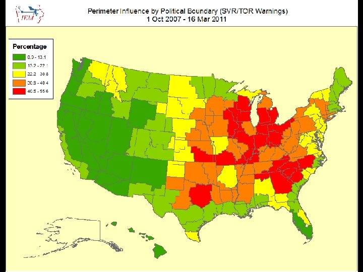
 Percentage of")
1 Oct 2007 – 15 Mar 2011: Number of Polygon Vertices (SVR+TOR) Percentage of Warnings 60 50 40 30 20 10 0 3 4 5 6 7 8 9 10 11 12 13 14 15 16 17 18 19 20 Number of Vertices
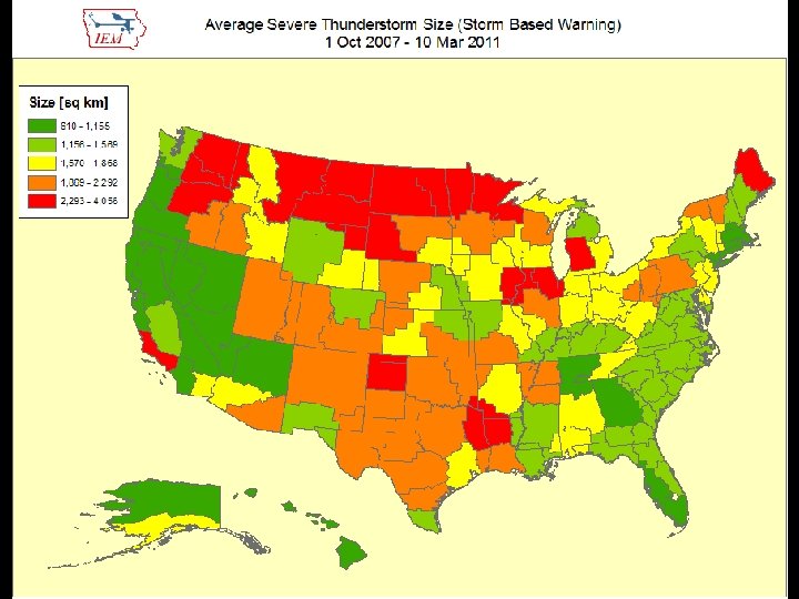
 Average")
Average SBW Size Versus County Size per WFO (SVR+TOR shown, Alaska not included) Average SBW Size [sq km] 3500 3000 2500 2000 1500 1000 500 0 0 5000 10000 15000 20000 25000 Average County Size [sq km] 30000 35000
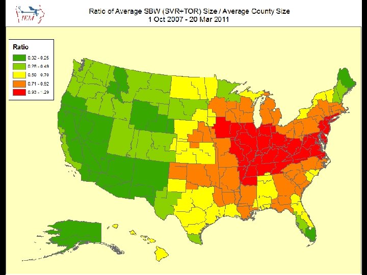
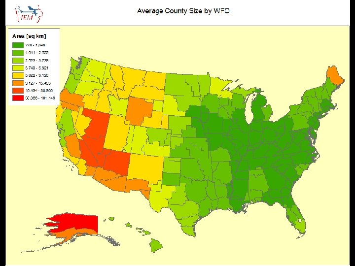

Lets get quantitative • Perimeter Influence – How much of the polygon perimeter coincides with a political boundary • Areal Verification – If the LSRs are buffered, what areal percentage verified • Size Reduction – How much smaller was the warning than the counties it was issued against.

~ 2 % of all warnings

Nationwide is around 25%

Nationwide Average: 65%

Oh daryl, what about this? County Warning • Perimeter ratio is small • So lets compute another metric measuring distance of vertex to county border

Overall Average: 75%

What is broken? • The warnings are constrained by political boundaries! – NWS Office can’t issue outside CWA – Warning product (VTEC) is still bound to UGC codes – Can’t issue SVR/TOR over Marine Zones, why ? !? ! No penalty for warning size in verification Warning issuance software Warning dissemination software (bad daryl) Warning display software (bad daryl) Some local NWS Office policies conflict with NWS directives, where’s the sheriff? • No topology checks, invalid geometries are OK • • •

Summary • ~ 50% of TOR/SVR Warnings are 4 sided • Only ~ 2 % of all SVR/TOR warnings are pure county retracements • 75% of polygon vertices are guided by county borders • SBWs have cut the size of warnings by over 50%, but the number of warnings has increased by 60%. • The Cubs will not win the World Series this year

Is this the solution?

Equally, unrealistic solutions • Warnings should be data, not products – Computers are the most important readers… – UGC codes should not be included • Warnings should come from NWS, not WFOs – NWS should be working as a team, instead of theftdoms • Polygons should be limited to 4 to 6 sides. • The Cubs develop talent from their farm system and not overpay for free agents that struggle with the rigors of playing left field.

NWS Issues Products Forecaster tries to figure out what the public wants Disseminates Computer angry! NWS Issues Data Computers deal with various users Disseminates Computer happy! Meathead happy! Public doesn’t call Congress.

Time for Questions? Daryl Herzmann 515. 294. 5978 akrherz@iastate. edu
- Slides: 38