The Gulf Coastal Plains Region 5 Subregions The

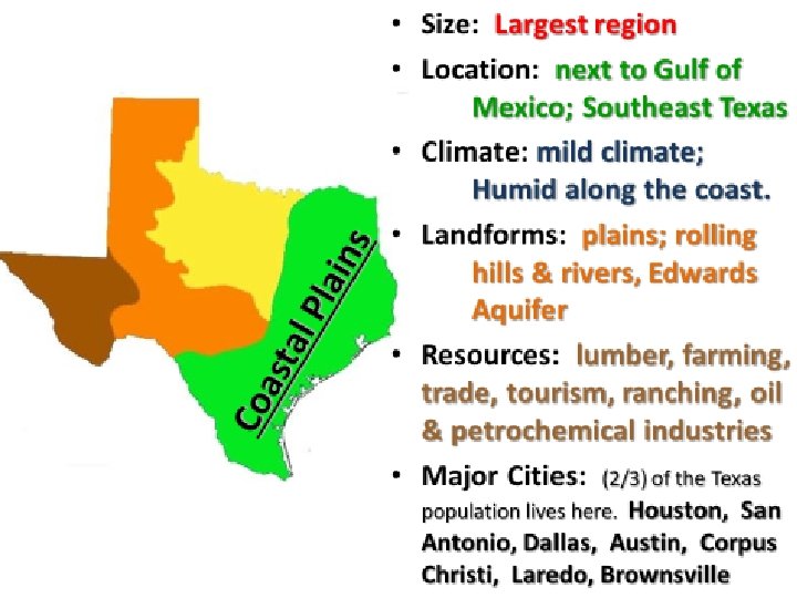
The Gulf Coastal Plains Region
 – Eastern most subregion • The Gulf")
5 Subregions: • The Piney Woods (blue) – Eastern most subregion • The Gulf Coast Plain (yellow) – South and west of the Piney Woods • The Post Oak Belt (purple) – West of both Piney Woods and Gulf Coast Plain • The Blackland Prairie (green narrow above purple) – Stretches west along Post Oak Belt • The South Texas Plain (green south) – West of the Gulf Coast Plain

Piney Woods • . Most of the land in the Piney Woods is rolling hills. • The Piney Woods also has one of the wettest climates of any Texas Subregion. • Rainfall helps support a large timber industry in the heavily forested area of the Piney Woods.

Piney Woods • Oil is another valuable natural resource in this subregion. • Large amounts of oil were discovered here in the 1930 s.

The Gulf Coast Plain The Gulf Coastal Plain • South and west of the Piney Woods lies the Gulf Coast Plain. • This subregion extends south along the Gulf Coast from the Sabine River to Corpus Christi Bay.

The Gulf Coast Plain • A chain of barrier islands runs nearly the entire length of the Texas coast. • These islands are covered by brush, grasses, and sand. • Shallow bays separate the islands from the mainland.

The Gulf Coast Plain • The coastal grasslands also support one of the largest livestock industries in Texas. • The Gulf waters are another valuable resource. • Fishing and shrimping are major sources of income for many Texans.

The Gulf Coast Plain • Oil is another offshore resource, with offshore oil rigs providing many jobs for Texans. • The center of the Texans and U. S. oil industry is Houston and Beaumont.

The Gulf Coast Plain • The area also has a large petrochemicals industry. • Petrochemicals are chemicals made from oil and natural gas. • They are used in most industries.

The Gulf Coast Plain • Ports provide another boost to the economy of the Gulf Coast Plain. • Some of the largest cities in this region are port cities: Houston, Galveston, Beaumont, Corpus Christi and Port Arthur.

The Gulf Coast Plain • Houston has the third largest seaport in the nation and a major center for international shipping. • The natural resources of the Gulf Coast Plain have boosted its industry and have attracted many people to the subregion.

South Texas Plain • The South Texas Plain has one of the richest farming areas in the nation. • Temperatures are warm for most of the year. • The Valley has fertile soils from sediment washed down the Rio Grande.

The Post Oak Belt • The Post Oak Belt begins just outside San Antonio and stretches north the Red River. • It lies west of the Piney Woods and the Gulf Coast Plain. • The Belt has a similar climate to that of the Piney Woods.

The Post Oak Belt • Cotton is a major crop as well as sorghum, corn and grain to feed livestock. • Livestock is a major industry. Farmers raise cattle and hogs.

Blackland Prairie • The Blackland Prairie subregion stretches west alongside the Post Oak Belt. • The climate here is similar to the Post Oak Belt’s climate; its wet and mild. • Rolling prairies cover the landscape.

Blackland Prairie • The area’s rich, black soils make it ideal for farming. • Farmers here grow cotton, grains and vegetables. • Farmers also raise cattle, chickens, and hogs.
- Slides: 17