The Global Observing System Stephen English ECMWF Stephen

The Global Observing System Stephen English ECMWF Stephen. English@ecmwf. int © ECMWF 7 th March 2016

Contents • The role of observations in data assimilation • Conventional observations • Satellite observations • The WMO Integrated Global Observing System (WIGOS) • OSCAR and SATURN EUROPEAN CENTRE FOR MEDIUM-RANGE WEATHER FORECASTS October 29, 2014 2

Role of observations Every 12 hours we assimilate ~20, 000 observations to correct the model’s variables…. The model has many more variables than we have observations. RMS error (m) SEVIRI 6. 2 µm Time (hours) Observations limit error growth and make forecasting possible….

Data sources: Conventional Instrument Parameters Height SYNOP SHIP METAR temperature, dew-point temperature, wind Land: 2 m, ships: 25 m BUOYS temperature, pressure, wind 2 m TEMPSHIP DROPSONDES temperature, humidity, pressure, wind Profiles PROFILERS wind Profiles Aircraft temperature, pressure wind Profiles Flight level data
 +")
Example of 6 hr conventional data: 28 Jan 2015 Aircraft Buoy Surface (synop) + ship Radiosondes

Conventional data issues ● Biases, duplicates, incorrect locations. ● Representivity error…. if we measure temperature here at ECMWF is it representative of model grid resolution? ● Data voids. ● Data quality – some radiosondes are good quality, others less so; absolute calibration can vary with age. ● Old alphanumeric codes -> BUFR. ● Sampling e. g. significant levels in radiosonde vs full resolution data. But, they are a direct, in situ measurement. Interpretation is usually more straightforward than remotely sensed data. EUROPEAN CENTRE FOR MEDIUM-RANGE WEATHER FORECASTS
. ● Rarely an absolute")
Remotely sensed data issues ● Poor vertical resolution (in general). ● Rarely an absolute measurement – long term drifts, observation biases. ● Data voids: less of a problem than for in situ, but there areas where data is hard to interpret. ● Data quality – whilst most remotely sensed observations are of very high quality, this can change suddenly. ● An indirect measurement – we need complex observation operators. ● Incompleteness of observation operators e. g. new species of trace gas affects measurement (HCN on IASI for example). • • But, they measure on a global or regional scale – often for years or even decades. Representivity error is lower – large volumes are more representative of what the model is trying to represent. EUROPEAN CENTRE FOR MEDIUM-RANGE WEATHER FORECASTS

What types of satellites are used in NWP? Advantages GEO - Regional coverage Disadvantages No global coverage by single satellite - Temporal coverage LEO - Global coverage with single satellite EUROPEAN CENTRE FOR MEDIUM-RANGE WEATHER FORECASTS

Satellite orbits AM + PM * Met. Op-A * NOAA-18 E-AM + PM * Met. Op-A * NOAA-18 * NOAA-15 * Met. Op-A AM + 2 x PM * NOAA-18 EUROPEAN CENTRE FOR MEDIUM-RANGE WEATHER FORECASTS * NOAA-19

Dual Metop-A and B fly with same ECT but 180 degree phase shift, leading to an effective ~50 m time difference. Allows global “AMVs”.

Satellite orbits Mid AM Europe Met. Op-B, A FY-3 A China T i m e Early AM DMSP F 17, F 18 NOAA-15 PM NOAA-19, S-NPP, Aqua, Terra, Aura, FY-3 B Adapted from EUROPEAN CENTRE FOR MEDIUM-RANGE WEATHER FORECASTS US

Example of 6 hr satellite data coverage: 28 Jan 2015 MW Sounders Scatterometers Satellite Geo Winds MW all-sky IASI Radio Occultation

Composition Ultraviolet sensors Polar IR + MW sounders Mass Radio occultation Sub-mm, and near IR plus Visible (e. g. Lidar) Geo IR Sounder Radar and GPS total path delay Moisture Geo IR and Polar MW Imagers Feature tracking in imagery (e. g. cloud track winds), scatterometers and doppler winds Wind EUROPEAN CENTRE FOR MEDIUM-RANGE WEATHER FORECASTS IR = Infra. Red MW = Micro. Wave

Metop

Impact of Satellite Observations by “FSO” a global measure of 24 hour forecast impact Emergence of “all-sky” humidity obs (MHS, SSMIS) as 2 nd most important after AMSUA. EUROPEAN CENTRE FOR MEDIUM-RANGE WEATHER FORECASTS 16

Full operational system. GOS + forecast changes with time ERA-Interim skill shows little change 1980 -2000 when there was little change in the GOS. The ATOVS era shows a gain of around 6 -18 hours in predictable skill compared to the TOVS era. Re-analysis system. Only GOS changes with time ERA-Interim excludes more recent data e. g. IASI and ASCAT so the impact of newer data is hard to judge. This compares to overall ECMWF gain in skill of about 2 -3 hours per year. TOVS ATOVS + Hyperspectral IR
 design Examples questions we use Data Assimilation techniques")
WMO Integrated Global Observing System (WIGOS) design Examples questions we use Data Assimilation techniques to study: • Very specific questions e. g. Would it be beneficial for the Chinese FY 3 program to move to the “early morning orbit” with the Europeans occupying the “mid morning orbit” and the Americans the “afternoon orbit”? • Preparation for future instruments such as lidar and radar (Earth. CARE) – will these observations make a difference? • Which observations are most critical to forecast skill? • Monitoring the quality of observations – protecting the operational system e. g. HCN event. • Protecting our needs e. g. Radiofrequency interference.

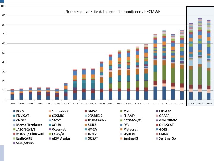
Developing WIGOS • Vision for WIGOS in 2025 adopted June 2009 • Vision for WIGOS in 2040 currently under development - Goal of new WIGOS vision by 2018 or 2019 - Sets goals for the Space Agencies and attempts to coordinate • Understanding WIGOS - WMO Space provide detailed support for satellite data from www. wmo-sat. info: - OSCAR lists what exists, what is planned, what it can do, how this compares to requirements: http: //www. wmo-sat. info/oscar/ - SATURN provides detailed information to prepare forthcoming launches: data availability, formats, meta data, test data, points of contact: https: //www. wmo-sat. info/satellite-user-readiness/ - The Product Access Guide provides information on existing datasets and how to obtain them: https: //www. wmo-sat. info/product-access-guide/ EUROPEAN CENTRE FOR MEDIUM-RANGE WEATHER FORECASTS October 29, 2014 19

Summary The Global Observing System is essential to weather forecasting Mass – is well observed by satellites and conventional observations, albeit only on the large scale. Moisture – satellite observations are data rich but difficult to exploit to their full potential. Radar and lidar may become important. Dynamics – wind observations are scarce. Aeolus (doppler wind lidar) may help. AMV impact has increased recently. Composition – NWP techniques have been successfully extended to environmental analysis (ozone, aerosol, trace gases…) Surface – Some “static” fields are needed e. g. vegetation, orography, land: sea, lakes; others are more dynamic e. g. sea ice, snow, soil moisture, surface temperature, flooding

OSCAR demonstration http: //www. wmo-sat. info/oscar/

Sun-Synchronous Polar Satellites Instrument Early morning orbit High spectral resolution IR sounder Mid Morning orbit Afternoon orbit Metop-A+B IASI Aqua AIRS S-NPP Cr. IS Microwave T sounder F 17 SSMIS Metop-A+B AMSU-A FY 3 C MWTS 2 DMSP F 18 SSMIS Meteor-M N 1 MTVZA NOAA-15, 18, 19 AMSU-A Aqua AMSU-A S-NPP ATMS Microwave Q sounder + imagers F 17 SSMIS Metop-A+B MHS DMSP F 18 SSMIS FY 3 A MWHS 2+MWRI NOAA-18, 19 MHS FY 3 B MWHS+MWRI S-NPP ATMS GCOM-W/AMSR-2 Broadband IR sounder Metop-A+B HIRS FY 3 C IRAS FY 3 B IRAS IR Imagers Metop-A+B AVHRR Meteor-M N 1 MSU Aqua+Terra MODIS NOAA-15, 16, 18, 19 AVHRR Composition (ozone etc). NOAA-19 SBUV AURA OMI, MLS GOSAT
 Instrument Early morning orbit Scatterometer Morning orbit Afternoon orbit Metop-A+B")
Sun-Synchronous Polar Satellites (2) Instrument Early morning orbit Scatterometer Morning orbit Afternoon orbit Metop-A+B ASCAT (Coriolis Windsat) Radar Cloud. Sat Lidar Calipso L-band imagery SMOS, SMAP SAC-D/Aquarius Non Sun-Synchronous Observations Instrument Radio occultation High inclination (> 60°) GRAS, GRACE-A, COSMIC MW Imagers Radar Altimeter Low inclination (<60°) GPM/GMI Meghatropiques/SAPHIR JASON RA + SAR, Cryosat, Sentinel-3
- Slides: 23