The Global Observing System for Climate Essential climate

The Global Observing System for Climate Essential climate variables, indicators and actions in the 2016 GCOS implementation plan to support the Paris Agreement goals GCOS Secretariat, WMO Han Dolman, Carolin Richter, Simon Eggleston

Improved observations lead to significant benefits ECV Requirements, Adequacy Reports, Plans Observations, Products, Open Data Science, Assessments, Policy Climate Services, Risk Assessments, Early Warning & Disaster Risk Reduction Policies Successful adaptation and mitigation, reduced climate risks, enhanced livelihoods, and food & water security.

GCOS Reports and Plans Adaptation & Mitigation Status 2015 Water, Energy and Carbon cycles New Plan 2016 I Additional Essential Climate Variables III II Emphasis on more help for networks in developing countries IV

Sea Level Rise Fisheries Sea Surface & Subsurface Salinity, Sea Level, Sea Surface Temperature Precipitation, Cloud Properties, Water Vapour Surface Temperature Water Ocean Acidification Carbon Dioxide, Methane Carbon Soil Moisture, River ischarge, Lakes, Groundwater, Cryosphere, Water use Inorganic Carbon Radiation Budgets, Temperature Wind speed & direction Coral Bleaching Agriculture Human Health Floods Droughts Water Resources Storms Deforestation Mitigation Ecosystem Loss Energy Ocean Surface Heat Flux, Sea Surface & Subsurface Temperature, Temperature Heat waves Soil Carbon, Above-ground Biomass, Fire, GHG Fluxes Systemic Risks Security Slow Economic Development Albedo, Latent and Sensible Heat fluxes, Land Surface Temperature Closing the Budget of Global Climate Cycle

GCOS ECVs Atmosphere Terrestrial Ocean Surface radiation budget, Albedo, Earth radiation budget, Ocean surface heat flux, sea Energy and surface temperature, latent and sensible heat surface temperature, temperature upper-air temperature, fluxes, land surface subsurface temperature surface and upper-air sind temperature speed Surface currents, subsurface Surface wind, upper-air Other physical currents, wind, pressure, lightning, properties ocean surface stress, sea aerosol properties state, transient traces Carbon dioxide, Carbon cycle and methane, other long-lived Soil carbon, Inorganic carbon, nitrous other GHGs GHG, ozone, precursors above-ground biomass oxide for aerosol and ozone Precipitation, Soil moisture, Sea surface salinity, cloud properties, Hydrosphere water vapour (surface), river discharge, subsurface salinity, sea level, water vapour (upper air), lakes, groundwater, sea surface temperature, Glaciers, ice sheets and ice Snow and ice Sea Ice shelves, permafrost, snow Plankton, oxygen, Land cover, LAI, FAPAR, Biosphere nutrients, ocean colour, fire marine habitat properties Human use of natural resources Water use, GHG fluxes Marine habitat properties

The Global Climate Observing System and the Carbon Cycle Atmospheric Concentrations Atmospheric Emission Enhance the existing ground-based observations by monitoring of isotopes, new technologies such as balloon capture and satellite based measurements. Biosphere Ensure consistency between datasets for FAPAR, LAI, Land surface temperature & aboveground biomass to better understand changes. Ocean carbonate system Land Use Change Increase the number of sites leading to improved information on seasonal and longer variability with a better regional resolution. Fire River Discharge More complete monitoring and reporting of river discharge and fluxes from land into the oceans. Greater use of satellite information to supplement ground based data. Coastal Areas Establish global monitoring of coastal areas, particularly mangroves, sea grass and salt marches which are believed to be carbon sinks. Permafrost Improve mapping of permafrost and seasonal freeze/thaw with satellite data supporting ground based observations. Improve standards and practices. Produce annual and high resolution datasets to supp mitigation such as RED projects will be created. network of experts to valid data is needed. Continue operational observations at <100 m resolution near-daily. Undertake validation Soil Carbon efforts aiming to improve accuracy. Reanalyse historic Cooperate with soil carbo exercises to produce accura archives. global maps. Fl measurements at 5 -ye intervals to supplement lon term experiments.

Annex A – Terrestrial ECV product requirements ECV Aboveground biomass Products Maps of AGB Maps of land cover Frequency Annual Resolution 500 m-1 km based on < 20% error for biomass values > 50 t/ha, 100 -200 m and 10 t/ha for biomass values ≤ 50 t/ha observations 250 m 15% (maximum error of omission and commission in mapping individual classes), location accuracy better than 1/3 IFOV with target IFOV 250 m 5 year 10 - 30 m 5% (maximum error of omission and commission in mapping individual classes), location accuracy better than 1/3 IFOV with target IFOV 10 -30 m 1 -10 years (incl. historical data) 10 -1000 m (depending on time period) 20% (maximum error of omission and commission in mapping individual classes), location accuracy better than 1/3 IFOV with target IFOV Annual Land cover Maps of high resolution land cover Maps of key IPCC land use, related changes and land management types Required measurement uncertainty

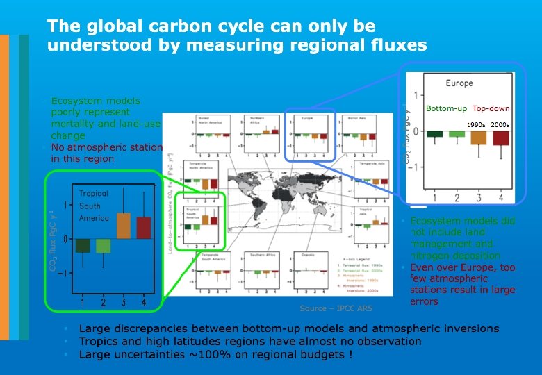
Targets HUMAN DIMENSION Who Time frame Performance indicator 1. Closing the carbon budget Quantify fluxes of carbon-related greenhouse gases to +/- 10% on annual timescales Quantify changes in carbon stocks to +/- 10% on decadal timescales in the ocean and on land, and to +/- 2. 5 % in the atmosphere on annual timescales Operators of GCOS-related systems, including data centres Ongoing Regular assessment of uncertainties in estimated fluxes and inventories Anthropogenic ECVs Anthropogenic water use Water used by humans for drinking water, reservoir storage and agricultural or industrial purposes Anthropogenic greenhouse gas fluxes Emissions from fossil-fuel use, industry, agriculture and waste sectors Emissions/removals by land-use sectors Emissions/removals by “land sink” Estimated fluxes by inversions of observed atmospheric composition

Can we now observe any reduction? Peters et al. , 2017

Challenges ahead • The game has changed since Paris • Do we have the correct transport models? • Do we have the correct amount and type of observations? • Where do uncertainties meet regional budgets: future satellite requirements • Can we close country budgets? • Can we deliver in time and how?
- Slides: 11