The Global Grid The global grid makes it

The Global Grid

The global grid makes it possible to state the “absolute location” of a place – exactly where it is. http: //www. psdgraphics. com/backgrounds/world-globe-background/ http: //matagalatlante. org/nobre/featpost/doc/featexamples. html

Absolute location – longitude & latitude – is like a global address. http: //amyrondinel. com/2010/09/home-is-where-the-heart-is/

Los Angeles, California: 34°N 118 W° http: //www. hightunnels. org/For. Educators/Planning/Full. Moon. Farm. Case. Study/planningorientationlatitude. htm

Washington, DC: 38°N 77 W°

Seattle, Washington: 47°N 122 W°

Tulsa, Oklahoma: 36°N 95°W

Oklahoma City: 35°N 97 W°

The absolute location of any place is the latitude + the longitude. http: //www. ukdivers. net/chartwork/chartintro. htm

http: //www. ukdivers. net/chartwork/chartintro. htm

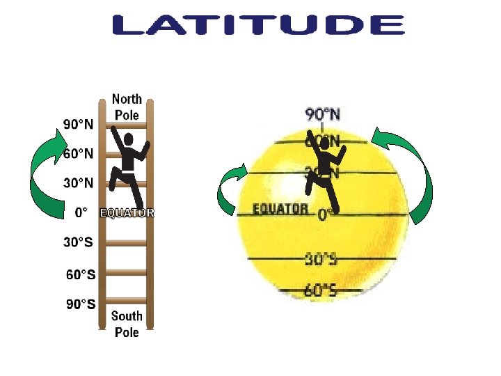
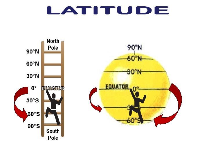
LATITUDE lines are the FLAT lines. http: //www. ukdivers. net/chartwork/chartintro. htm

The most famous line of latitude is the Equator.

The Equator is the longest line of latitude, because it’s at the “fattest” part of the earth. http: //www. cliparthut. com/clip-arts/908/globe-with-latitude-lines-908531. jpg

But up by the North Pole – and down by the South Pole – the lines are shorter.

Latitude lines run flat east and west, but they don’t measure how far east or west something is. That’s not my job. That’s longitude’s job! (We’ll get to that later. )

Latitude lines measure how far north or south you are from the Equator.

90°N Nort h Pole 60°N Think of LATITUDE like the rungs of a ladder. 30°N 0° EQUATOR 30°S It’s how you climb up and down the globe. 60°S 90°S (ladder sounds like latitude). Sout h

Anywhere you are on the 30°N line, you are 30° north of the Equator.

And anywhere you are on the 30°S line, you are 30° south of the Equator.

And now, we take a moment to focus on the Equator. . . http: //www. geolounge. com/wp-content/uploads/2014/08/latitude. png

http: //www. worldatlas. com/aatlas/newart/locator/equator. htm

on the Equator in Ecuador http: //www. elmundodeanders. com/Mitad%20 del%20 Mundo. htm http: //www. southernhorizons. com/images/galapaos/Mapsinf/SAmap. jpg

http: //www. leeabbamonte. com/lee/south-america/

and in Brazil http: //www. questconnect. org/sa_j_brazil_crossing. htm http: //www. advrider. com/forums/showthread. php? t=314904

Macapá, Brazil http: //www. flickr. com/photos/teamtrev/35447999/

http: //ahunsberger. blogspot. com/2008/01/geog-411 -political-maps. html in Gabon http: //www. flickr. com/photos/27767476@N 04/2987565877/ http: //www. flickr. com/photos/33357097@N 00/2334967076/

http: //www. travelpod. com/travel-photo/bonthorn/1/1210984380/crossing-the-equatorx. jpg/tpod. html in Uganda http: //www. travelpod. com/travel-blog-entries/jmo_world_tour/1088505180/tpod. html

and in Kenya http: //www. fimafrica. org/7. html

http: //www. wainscoat. com/kenya/samburu. html http: //www. travelblog. org/Bloggers/Twiga-Kali/

in Indonesia http: //www. horizonsunlimited. com/newsletter/2008 -10. shtml http: //afe. easia. columbia. edu/main_pop/kpct/ct_seast. htm

http: //indahnesia. com/picture/SUM/004/equator_monument. php http: //www. tripadvisor. com/Location. Photos-g 317101 -Pontianak_Borneo. html#27121388

Bethany’s latitude is 35°N, because we are 35° north of the Equator.

Latitude is all about how far you are from the Equator – up or down the globe (north or south).

So remember to think of latitude like the rungs of a ladder. http: //www. shoponline 2011. com/m~c-laptop-computers~b-462~f-1 -646838_679798 -679809. aspx http: //www. nauticus. org/currptpless 01. html

Latitude is how you climb up and down the globe.

. . . o i t s e qu o ns e d u t i t a l n

DE ITU NG LO http: //www. ukdivers. net/chartwork/chartintro. htm

Longitude lines are always long.

EVERY longitude line goes from the South Pole all the way to the North Pole.

Lines of longitude are North Pole f a r t h e s t a p a r t at the Equator. They get closer together towards the poles. South Pole

Longitude lines tell us how far we are from the Prime Meridian. http: //www. ukdivers. net/chartwork/chartintro. htm

Anywhere you are on the 30°E line, you are 30° east of the Prime Meridian. http: //www. hammondmap. com/catalog/classroom_activities/latlong 1. html

Anywhere you are on the 30°W line, you are 30° west of the Prime Meridian. http: //www. hammondmap. com/catalog/classroom_activities/latlong 1. html

The Equator is a real location. But who decided where to put the Prime Meridian?

In the 1500 s, when the Portuguese controlled the Atlantic, they drew the first Prime Meridian passing through the Madeira Islands. Graphicmaps. com

Graphicmaps. com http: //www. fotosearch. com/clip-art/spanish. html We control the Atlantic. So, of course, it makes perfect sense that we would put the Prime Meridian through OUR land. WE are the center of the world! Portugal owned the Madeira Islands, so they thought it was a good idea to use THEIR land for the Prime Meridian location.

http: //www. math. nus. edu. sg/aslaksen/gem-projects/hm/0203 -1 -10 -instruments/glossary. htm This Prime Meridian was used by most mapmakers for the next 300 years.

When the British got control of the Atlantic, they set a new Prime Meridian, right through England! Graphicmaps. com

NOW look who’s in charge of the Atlantic! England is now the center of the universe, so we will re-draw the Prime Meridian to go through England! http: //colquitt. k 12. ga. us/wjwpg 2/Explorers/explor. htm Graphicmaps. com

In 1884, 25 countries reached agreement at a conference in Washington D. C. that the location in Greenwich, England, would be the “Prime Meridian” - zero degrees. Over a period of many years, other countries accepted and adopted the decision. http: //www. brannelastronomy. com/articles/meridian. htm

Royal Observatory, Greenwich, England the Prime Meridian http: //www. randform. org/blog/? p=1472 http: //www. flickr. com/photos/31808957@N 04/2993256325/

http: //www. flickr. com/photos/black_coffee_blue_jeans/279214384/

in France http: //www. flickr. com/photos/12989909@N 07/2098367402/

in Spain http: //picasaweb. google. com/lh/photo/5 xia. Eepc 3 LBmk. L 8 Bi. YQk. MA

http: //reference. findtarget. com/search/Greenwich_Mean_Time/

in Ghana http: //www. flickr. com/photos/ascentstage/2689066897/

Bethany’s longitude is 97°W, because we are 97° west of the Prime Meridian.

So remember that longitude lines tell us how far east or west we are from the Prime Meridian. http: //www. ukdivers. net/chartwork/chartintro. htm

. . . e d u it s n q o i t s ue n o g n lo

0° 0° ? http: //geographyworldonline. com/tutorial/lesson 3. html

This buoy marks where the Prime Meridian and the Equator intersect. http: //174. 143. 247. 143/site_media/user_images/krupa/00__jpg_500 x 500_q 85. jpg http: //www. fredsplace. org/images/dallas 1/week 5/

Hemispheres

Is the U. S. in the northern or southern hemisphere? North West East p: //cuwhist. files. wordpress. com/2010/12/world-political-map. jpg South

So is the on Maine be 45° N or 45°S? http: //www. hightunnels. org/For. Educators/Planning/Full. Moon. Farm. Case. Study/planningorientationlatitude. htm

And is the U. S. in the western or eastern hemisphere? North West East p: //cuwhist. files. wordpress. com/2010/12/world-political-map. jpg South

And is the on Maine be 70° E or 70°W? http: //www. hightunnels. org/For. Educators/Planning/Full. Moon. Farm. Case. Study/planningorientationlatitude. htm

So the absolute location of the 45°N, 70°W. http: //www. hightunnels. org/For. Educators/Planning/Full. Moon. Farm. Case. Study/planningorientationlatitude. htm is

Is Peru in the northern or southern hemisphere? North West East p: //cuwhist. files. wordpress. com/2010/12/world-political-map. jpg South

So is the x on Peru 15° N or 15°S? http: //www. worldatlas. com/webimage/countrys/sanewlat. gif

And is Peru in the western or eastern hemisphere? North West East p: //cuwhist. files. wordpress. com/2010/12/world-political-map. jpg South

And is the x on Peru 75° W or 75°E?

So the absolute location of the is 15°S, 75°W.

Australia in the northern or southern hemisphere? North West East p: //cuwhist. files. wordpress. com/2010/12/world-political-map. jpg South

So is the x on Australia 20° N or 20°S?

And is Australia in the western or eastern hemisphere? North West East p: //cuwhist. files. wordpress. com/2010/12/world-political-map. jpg South

So is the x on Australia 125° W or 125°E?

So the absolute location of the is 25°S, 125°E.
- Slides: 79