The Global Fundamental Geospatial Data Themes UNGGIM UNITED

The Global Fundamental Geospatial Data Themes UN-GGIM UNITED NATIONS COMMITTEE OF EXPERTS ON GLOBAL GEOSPATIAL INFORMATION MANAGEMENT

Presentation Topics • Recognition of contributions by the UN-GGIM Arab States Region to the completion of the Fundamental Data Themes • Quick overview of fundamental data themes and the relationship to the SDGs • The IGIF – Strategic Pathway 4 – DATA • Actions for Data within the IGIF • Tools that support actions on data • Recommendations for consideration

Global Fundamental Geospatial Data Themes The Global Fundamental Geospatial Data Themes are 14 themes, from Geographic Names, Addresses to Land Cover and Imagery. This presentation will take you through themes and demonstrate what they are, how they can be used, and why they are fundamental. Implementing themes will necessitate the integration of information from National Mapping Agencies, National Statistical Offices and other institutions to produce standardised, fundamental data, for use within member states, and also, to support initiatives such as the 2030 Sustainable Development Goals.
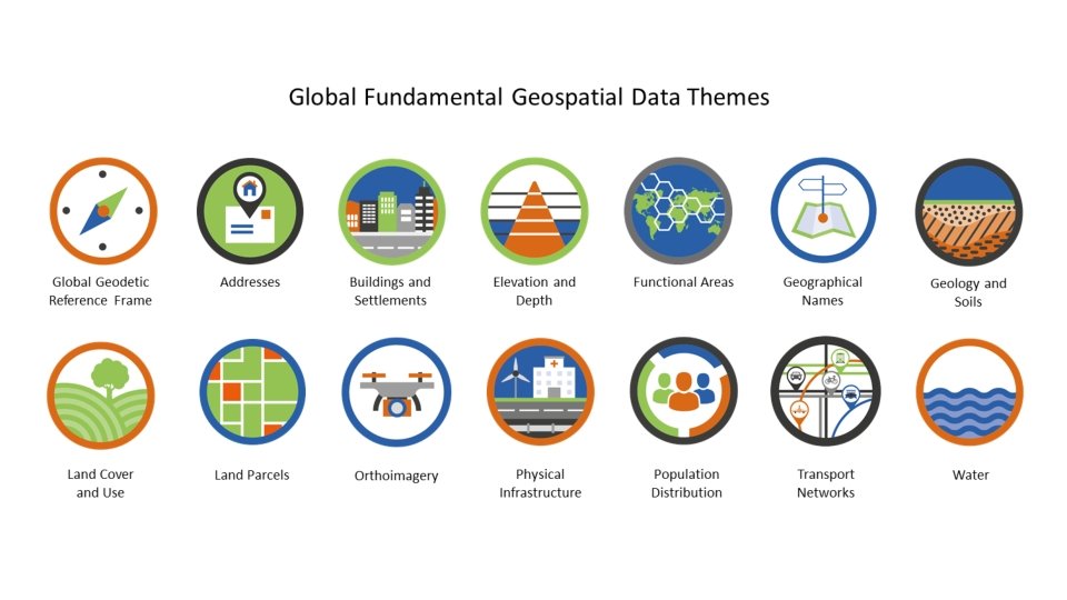

Global Geodetic Reference Frame The Global Geodetic Reference Frame is the framework which allows users to precisely determine and express locations on the Earth, as well as to quantify changes of the Earth in space and time. It is not a data theme in the sense of the other themes, but it is a prerequisite for the accurate collection, integration, and use of all other geospatial data.

Addresses An Address is a structured label, usually containing a property number, a street name and a locality name. It’s used to identify a plot of land, a building or part of a building, or some other construction, together with coordinates indicating their geographic position. Addresses are often used as a proxy for other data themes such as Land Parcels.

Buildings and Settlements A Building refers to any roofed structure permanently constructed or erected on its site, for the protection of humans, animals, things, or the production of economic goods. Settlements are collections of buildings and associated features where a community carries out socioeconomic activities.

Elevation and Depth The Elevation and Depth theme describes the surface of the Earth both on land under a body of water, relative to a vertical datum.

Functional Areas are the geographical extent of administrative, legislative, regulatory, electoral, statistical, governance, service delivery and activity management areas.

Geographical Names provide orientation and identity to places. They are location identifiers for cultural and physical features of the real world, such as regions, settlements, or any feature of public or historical interest. They are often used as a proxy for other data themes such as Buildings and Settlements.

Geology and Soils Geology is the composition and properties of geologic materials (rocks and sediments) underground and outcropping at the Earth’s surface. It includes bedrock, aquifers, geomorphology for land marine environments, mineral resources and overlying soils. Soils are the upper part of the Earth’s crust, formed by mineral particles, organic matter, water, air, and living organisms.

Land Cover and Land Use Land Cover represent the physical and biological cover of the Earth’s surface. Land Use is the current and future planned management, and modification of the natural environment for different human purposes or economic activities.

Land Parcels are areas of land or more generally of the Earth’s surface (land and/or water) under common rights (such as ownership or easements), claims (such as minerals or indigenous land) or use. This theme can include individual fields and cadastral parcels.

Orthoimagery is geo-referenced rectified image data of the Earth's surface, from satellite or airborne sensors. Although technically not a theme in its own right, Orthoimagery is included as, when interpreted, it’s a widely-used data source for many other data themes.

Physical Infrastructure The Physical Infrastructure theme includes industrial & utility facilities, and the service delivery facilities associated with administrative & social governmental services such as public administrations, utilities, transport, civil protection, schools and hospitals.

Population Distribution The Population Distribution theme covers the geographical distribution of people, including population characteristics.

Transport Networks are the suite of road, rail, air, cable and water transport routes and their connectivity.

Water Transport Networks are the suite of road, rail, air, cable and water transport routes and their connectivity.

From Strategic Pathway 4 DATA Elements of Data Themes Custodianship, Acquisition and Management Data Supply Chains Data Curation and Delivery Guiding Principles Governance Metadata Authoritative Demand Driven Consistent Identification Standards Timeliness Efficiency Accessibility Provenance Security Reusable Formats Integrity Respected Rights Quality Management Key Actions for Strengthenin g Geospatial Information Management Getting Organized Data Framework Data Inventory Maintained Geodetic Infrastructure Planning for the Future Managing Data Sustainably Custodianship Policy Data Governance Data Management Maintained Metadata Data Release Storage/Retrieval Systems Integrating Data Geospatial/Statistical Integration Geocoding and Aggregation Data Supply Chains Data Interoperability Fundamental Geospatial Data Themes Data Theme Road Map Template Metadata Creation Checklist Data Theme Description Data Custodianship Policy Principles Guidance for Improving Geodetic Infrastructure Data Governance Roles Global Statistical Geospatial Framework Data Management Plan Elements Geospatial/Statistical Integration Data Inventory Questionnaire Dataset Profile Template Gap Analysis Matrix Outcomes Data Capture Data Acquisition Program Data Theme Road Map Interrelated and/or Prerequisite Actions Maintaining Accurate Positioning Dataset Profiles Data Gap Analysis Tools to Assist in Completing the Actions Capturing and Acquiring Data Geospatial Strategy (SP 1) Country-level Action Plan (SP 1) Geospatial Information Coordination Unit (SP 1) Policy Framework (SP 2) Data Release Guidelines Storage Solutions (SP 5) Metadata Standards (SP 6) Governance Model (SP 1) Licensing Models (SP 2) Establishing Partnerships (SP 7) Geospatial Steering Committee (SP 1) New Data Capture Methods (SP 5) Identify Key Stakeholders (SP 9) Increased Range and Scope of Authoritative Data A Critical Mass of Centrally Coordinated Data Cost Reduction Through Productivity Improvements Ability to Monitor and Measure Progress Towards Achieving the SDGs

Key Actions on Data for Country-level Action Plan Elements of Data Themes Custodianship, Acquisition and Management Data Supply Chains Data Curation and Delivery Guiding Principles Governance Metadata Authoritative Demand Driven Consistent Identification Standards Timeliness Efficiency Accessibility Provenance Security Reusable Formats Integrity Respected Rights Quality Management Key Actions for Strengthenin g Geospatial Information Management Getting Organized Data Framework Data Inventory Maintained Geodetic Infrastructure Planning for the Future Managing Data Sustainably Custodianship Policy Data Governance Data Management Maintained Metadata Data Release Storage/Retrieval Systems Integrating Data Geospatial/Statistical Integration Geocoding and Aggregation Data Supply Chains Data Interoperability Fundamental Geospatial Data Themes Data Theme Road Map Template Metadata Creation Checklist Data Theme Description Data Custodianship Policy Principles Guidance for Improving Geodetic Infrastructure Data Governance Roles Global Statistical Geospatial Framework Data Management Plan Elements Geospatial/Statistical Integration Data Inventory Questionnaire Dataset Profile Template Gap Analysis Matrix Outcomes Data Capture Data Acquisition Program Data Theme Road Map Interrelated and/or Prerequisite Actions Maintaining Accurate Positioning Dataset Profiles Data Gap Analysis Tools to Assist in Completing the Actions Capturing and Acquiring Data Geospatial Strategy (SP 1) Country-level Action Plan (SP 1) Geospatial Information Coordination Unit (SP 1) Policy Framework (SP 2) Data Release Guidelines Storage Solutions (SP 5) Metadata Standards (SP 6) Governance Model (SP 1) Licensing Models (SP 2) Establishing Partnerships (SP 7) Geospatial Steering Committee (SP 1) New Data Capture Methods (SP 5) Identify Key Stakeholders (SP 9) Increased Range and Scope of Authoritative Data A Critical Mass of Centrally Coordinated Data Cost Reduction Through Productivity Improvements Ability to Monitor and Measure Progress Towards Achieving the SDGs

Actions for Fundamental Data from SP 4 of the IGIF Key Actions for Strengthening Geospatial Information Management Getting Organized Data Framework Data Inventory Dataset Profiles Planning for the Future Data Gap Analysis Data Theme Road Map Capturing and Acquiring Data Capture Data Acquisition Program Maintaining Accurate Positioning Maintained Geodetic Infrastructure Managing Data Sustainably Custodianship Policy Data Governance Data Management Maintained Metadata Data Release Storage/Retrieval Systems Integrating Data Geospatial/Statistic al Integration Geocoding and Aggregation Data Supply Chains Data Interoperability

Tools for Fundamental Data – Data Inventory Questionnaire General Question: Existence of a National Geospatial Framework?

Administrative Area Boundary Data

Land Parcel and Cadastral Boundary Data

Population Datasets

Actions to Consider on Fundamental Data after the 7 th Plenary • Review Strategic Pathway 4 (SP 4) on Data (http: //ggim. un. org/IGIF/part 2. cshtml) • Take note of the Actions included in SP 4 • Review the list of tools related to SP 4 • Select the first action to initiate work on Data within the IGIF • Share your experiences
- Slides: 26