The Global Earth Observation System of Systems GEOSS
 Siri-Jodha Singh Khalsa National Snow and")
The Global Earth Observation System of Systems (GEOSS) Siri-Jodha Singh Khalsa National Snow and Ice Data Center sirijodha. khalsa@ieee. org

Briefly. . • GEOSS origin, structure & goals • GEOSS Architectural Principles • Current activities
 – established by 3 ministerial-level summits –")
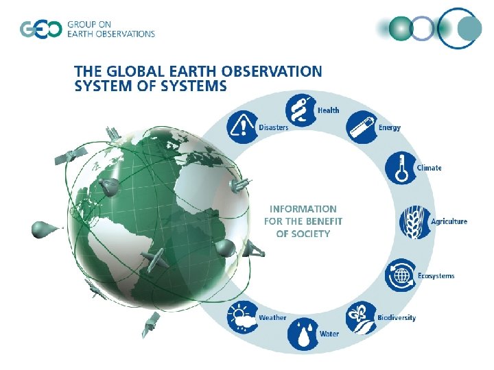
Background • Group on Earth Observations (GEO) – established by 3 ministerial-level summits – includes 72 member countries, the European Commission, and 52 organizations with a mandate in Earth observation • The vision of GEO is to create a Global Earth Observation System of Systems (GEOSS) to help realize a future wherein decisions and actions for the benefit of humankind are informed via coordinated, comprehensive and sustained Earth observations and information.

Structure • • GEO is governed by a Plenary and an Executive Committee – Membership is voluntary and decisions are by consensus Members agree to a 10 -year Implementation Plan, which outlines how GEOSS will work – Focused on nine “Societal Benefit Areas” – The Work Plan consists of over 100 individual tasks Four Committees to guide the implementation of the 10 -Year Plan. – Organized around “transverse” areas of GEOSS development: architecture and data, capacity building, science and technology, and user engagement – Interested Members and Participating Organizations contribute to these tasks, which are overseen by one of the four Committees The GEO Secretariat supports the Members Committees in carrying out the tasks described in the Work Plan

Not Starting from Scratch • GEOSS is being built initially from existing systems and initiatives – emphasis is on the creation of synergies among contributed components – idea is to leverage existing programs and established standards wherever possible, while broadening convergence of systems based on interoperability arrangements agreed to by consensus

Whole is Greater than Sum of Parts • Contributed components should combine to produce an overall system that is capable of providing data and information to meet societal needs better than the individual components operating in isolation. • Such a system is driven by user needs, supports a broad range of implementation options, and is able to incorporate new technology and methods as they emerge. • Contributed components include observing, processing, modeling and data dissemination capabilities that are provided by GEO Members and Participating Organizations.

Interoperability Arrangements • No attempt to build a monolithic data system through which all earth observation data will be managed • Systems contributed to GEOSS continue to operate within their own mandates • But systems should also be designed or adapted so their interfaces support interoperability • Interactions between systems take place according to agreed-to “Interoperability arrangements” based on non-proprietary, open standards

Core Components • Fundamental to the operation of GEOSS is access to information about its components. – Contributed components are described in the “Components Register” – The services these components offer are described in the “Services Register. ” – The interoperability arrangements used by GEOSS components are described in the “Standards and Interoperability Register. ” • All GEOSS registries are interoperable and accessible via the GEOSS Clearinghouse • The GEOSS Portal is the gateway to all of GEOSS

GEOSS Core Architecture GEOSS Clearinghouse Users GEOSS Component and Service Registries Services Registry Components Registry Communit y Catalogs GEO Portal Standards and Interoperability Forum GEOSS Components & Contributor Services GEOSS Standards and Interoperability Registry Standards Special Arrangement s
 UDDI eb. RS Z 39. 50/ OGC JAXR SRU")
Registries Interaction (http: //geossregistries. info/) UDDI eb. RS Z 39. 50/ OGC JAXR SRU CSW Web UI GEOSS Components offer GEOSS Service and Components Registry Z 39. 50/ SRU Web UI GEOSS Standards Registry GEOSS Standards GEOSS Services expose may become nominate U. S. A. GEO Members and Participating Organizations GEOSS Special Arrangements External Standards Bodies IEEE SIF Subject Matter Experts
 Interoperability Process Pilot Project (IP")
Current Activities • • Architecture Implementation Pilot (year 2) Interoperability Process Pilot Project (IP 3) Standards and Interoperability Forum (SIF) IEEE Committee on Earth Observations (ICEO) – http: //www. ieee-earth. org/ – Standards Working Group – Best Practices Registry – GEOSS Workshops – Energy Community of Practice – Data Quality/ Cal. Val – Earthzine: http: //www. earthzine. org/

Appendix - Progress Report, Capetown Summit

The Cape Town Ministerial Summit 2007 Earth Observation for Sustainable Growth and Development The Summit allowed: • To highlight early progress of GEO and key achievements in the Implementation of GEOSS; • To bring emerging priorities to the attention of Ministers; • For Ministers to commit to these priorities through The Cape Town Declaration.

The Cape Town Ministerial Summit 2007 The Summit was the opportunity: • To highlight early progress of GEO and key achievements in the Implementation of GEOSS (The First 100 Steps to GEOSS, The Full Picture) • For Ministers to commit to emerging priorities through The Cape Town Declaration.

The Cape Town Declaration • Value of Earth Observations • Data Sharing Principles • Commitment to Sustainable, Interoperable Systems • Protection of Frequencies • Need to Explore Ways and Means for the Sustained operations of… …GEOSS Components

Priorities for the 2008 -2010 timeframe • • • Harmonisation of portals (data and services) Ensuring sustainability of observing systems Bringing new funding Cost benefit analysis Iridium NEXT
 Meeting Geneva, Switzerland, 18 -19 February 2008 - Draft")
Committee Co-Chairs Coordination (C 4) Meeting Geneva, Switzerland, 18 -19 February 2008 - Draft Agenda 1 Opening (Chair) 2 Plenary IV/Summit outcome and consequences for Committees 3 Report on Recent Committee Meetings 4 Issues emerging from Work Plan Progress and Committee Oversight 5 Work Plan Update 6 GEO Portal Process 7 GEO Cost Benefit Analysis and GEO Performance Indicators 8 IGOS-P transition into GEO 9 Coordination between Committees 10 Agenda for 2008 11 AOB, Review of Actions and Recommendations
")
Appendix (from Nebert IOC Presentation at AIP Worksop)

Community Portals The community portals listed on this page are part of the GEOSS Initial Operating Capability (IOC). Portals provide end-user access to data and analytical capabilities for specific domains. Items registered in the GEOSS Component and Service Registry are shown with an ®. • • • Mapufacture (Africa wild fire scenario) SEDAC Map Client (Polar E&B scenario) GEO Connections Discovery Portal (Polar E&B scenario) ® ESA Service Support Environment (Oil Spill scenario) SERVIR data portal (Hurricane scenario) ® Data. Fed ® Earth Observation Grid Processing on Demand ® GEO-UA ® Geo. Connections Discovery Portal ® • • • Global Biodiversity Information Facility Data Portal ® INSPIRE geo-portal ® Incorporated Research Institutions for Seismology, Data Management Center ® GI-go Geo. Browser ® Information System and Data Center ® International Directory Network: A Portal for Group on Earth Observations ® NASA Earth Science Gateway ® NASA Socioeconomic Data and Applications Center ® U. S. Geospatial One-Stop Portal ®

Clearinghouse and Community Catalogues • Three Clearinghouse candidates were demonstrated as part of AIPilot, Phase 1 – FAO Geo. Network, Compusult, and ESRI • Catalogues used and/or registered ® : – – – – Global Change Master Directory (African Wildfire Scenario) ® METOP EUMETSAT CSW (oil Spill Scenario) SPOT Image Ionic CSW (oil Spill Scenario) MUIS Catalogue (oil Spill Scenario) SAR ESA CSW (oil Spill Scenario) Ionic Catalog CSW (oil Spill Scenario) JAXA CSW (volcano Scenario) Geo. Connections Discovery Portal Catalog (Polar E&B scenario) INSPIRE catalogue ® ECHO ® GI-cat Federated Catalog ® NASA Earth Science Gateway ® U. S. Geospatial One-Stop ®

Workflow Management, Processing Services The following Workflow Management components are part of the GEOSS Initial Operating Capability (IOC) and were used in demonstration scenarios as indicated: – Catalogue Workflow Spacebel (Oil Spill) – SPS EO Profile Workflow Spacebel (Oil Spill) – EO-1 Workflow Chaining Service (Africa fires) ® One Processing Services component was demonstrated: – EO-1 Thermal Classification Web Processing Service (Africa fires) ®

Data Access Services • • • • • • EO 1 SPS – EO 1 Satellite Sensor Tasking (African Fire Scenario) EO 1 data (African Fire Scenario) Image Data JAXA WMS/CSW (Africa E&B) Landsat 7 WMS Global Mosaic (Africa E&B) Feasibility Server MISEO Astrium (Oil Spill Scenario) MERIS SPS Datamat/ESA ((Oil Spill Scenario) SPOT Image SPS (Oil Spill Scenario) Sea Surface Temp NERC WMS (Oil Spill Scenario) PALSAR Image JAXA WCS (Oil Spill Scenario) Wind ASA WMS (Oil Spill Scenario) ASAR Image Infoterra/ESA WMS (Oil Spill Scenario) SPOT Image WMS/WCS (Oil Spill Scenario) ALOS Image JAXA WMS/WCS (Volcano Scenario) EO-1 image JAXA WMS/WCS (Volcano Scenario) Data. Fed WCS ® IMAGE 2000 ® Integrated CEOS European Data Server ® JAXA Web Coverage Service ® JAXA Web Map Server ® NASA-SSE-Helio. Clim-1 ® WGISS Test Facility for CEOP prototype system ®

Other Data Access Services • • • • Gridded Population Data SEDAC WMS (African wildfire scenario) Global Land Cover 2000 JRC WMS/WCS server (African E&B scenario) Soils data JRC WMS/WCS server (Africa E&B scenario) Protected Areas JRC WMS/WFS (Africa E&B scenario) Global Biodiversity GBIF Information Facility (data. gbif. org) (African E&B scenario) CARMA Caribou migration data Cubwerx WMS (Polar E&B scenario) Geology NRCan WMS (Polar E&B scenario) Vegetation and Wetlands NRCan WMS (Polar E&B scenario) Snow and Ice Data Center - NSIDC WMS (Polar E&B scenario) Atlas of the Cryosphere (Polar E&B scenario) ® Land Cover and Population FAO WMS (Volcano scenario) Land Use and Population JAXA WMS/WCS (Volcano Scenario) Geogratis (Canada) ® NASA Socioeconomic Data and Applications Center ®
- Slides: 24