
The Glob Glacier project Espen Volden European Space
The Glob. Glacier project Espen Volden European Space Agency Earth Observation Science, Applications and Future Technologies Department Frank Paul University of Zurich Department of Geography
The Glob. Glacier project New activity within ESA’s Data User Element (DUE) programme Aim: Establish services for operational glacier monitoring from space, complementing and strengthening the existing services and network Users: Science community studying glaciers in the context of climate change Budget: 950 K€
The Glob. Glacier project Objectives Products responding to • Operational needs & requirements of a certain number of users who will be actively involved in the project • Requirements of the GCOS implementation plan for UNFCCC & GCOS "Systematic Observation Requirements for Satellitebased Products for Climate" Priority application areas: • complementing and completing the WGI with 2 D vector outlines • changes in glacier length, size, and volume • global trends of climate change and sea level rise contribution
The Glob. Glacier project Service extent Total number of glaciers to be investigated will vary according to the information products: from selected mass balance glaciers to tens of thousands of glaciers worldwide Geographical areas: glaciers from at least • Europe – Alpes • Europe – North • Africa • Asia • South-America • North America • New Zealand Time period: Glaciers will also be analyzed over time, going back 10 -20 years.
The Glob. Glacier project User requirements meetings 22 -23 June 2006, University of Zurich 16 August 2006, Cambridge Objectives: Define requirements for the information products to be developed and implemented in the Glob. Glacier project Output of the meeting: • A user requirements document with six products • Confirmed interest from meeting participants to participate • Document for a proposed co-operation between Glob. Glacier and the GLIMS initiative
The Glob. Glacier project Involved user groups: • WGMS • GLIMS • scientists (cryosphere, climate modelling, sea-level-rise) Interested users: • GTOS/GCOS • UNESCO (GRID-Geneva) • hydrological programmes and organisations • further scientists and the general public

The Glob. Glacier project Areas of interest: • Representative key regions (without the two Ice Sheets) • entire mountain ranges or massifs • several 10’ 000 km 2 Selection criteria for representative regions: Climate change detection: • Include and extend available long-term in-situ measurements • Bridge geographic gaps of the world glacier inventory (WGI) also with respect to DEM coverage (outside SRTM) • include different glacier geometries (size, aspect, dynamics, …) Sea level rise: • Large area covered, climatically sensitive region Close coordination with GLIMS and WGMS

The Glob. Glacier project Products 1. Area: Digital map of glacier outlines + a level 2 product that can readily be ingested into the GLIMS database (including individual glaciers with topographic parameters) 2. Snowline: Position of the end of summer snowline (ELA) for mass balance determination 3. Terminus position: Coordinates of lowest glacier elevation or vector line marking the terminus 4. Topography: Digital map of surface elevation (DEM), both from the ice surface and outside 5. Elevation change: Time slices of DEMs or point elevation trends 6. Velocity: Velocity fields or velocities at individual points
Schedule • Planned start: Summer 2007 • Duration: 3 years • Three project phases: - Definition phase (6 months) - Development phase (10 months) - Production and Validation Phase (20 months)
Organization of Glob. Glacier • 5 consortium partners & 5 Ph. Ds – Universities of Zurich (lead), Oslo and Edinburgh – Gamma Remote Sensing (CH) and ENVEO (AU) • 5 work packages covering the 6 products – each lead by one of the consortium members – close interactions among the WPs – full documentation of applied standards / techniques • Close interaction with user groups - 4 user meetings in Zurich defining the requirements, testing the products, reporting about the service - advisory board provides guidelines global outreach
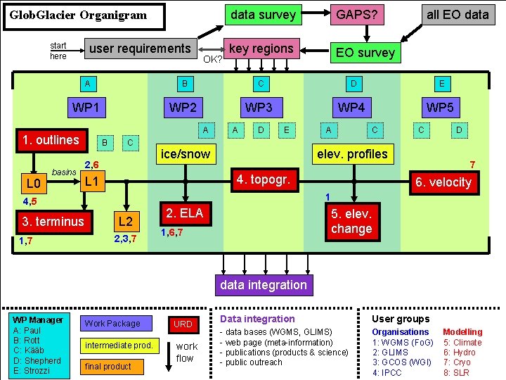
Glob. Glacier Organigram start here user requirements key regions EO survey all EO data B C D E WP 1 WP 2 WP 3 WP 4 WP 5 basins A B C 2, 6 3. terminus A D E ice/snow A C C elev. profiles 4. topogr. L 1 D 7 6. velocity 1 4, 5 1, 7 GAPS? A 1. outlines L 0 OK? data survey L 2 2, 3, 7 2. ELA 5. elev. change 1, 6, 7 data integration WP Manager A: Paul B: Rott C: Kääb D: Shepherd E: Strozzi Work Package intermediate prod. final product URD work flow Data integration User groups - data bases (WGMS, GLIMS) - web page (meta-information) - publications (products & science) - public outreach Organisations 1: WGMS (Fo. G) 2: GLIMS 3: GCOS (WGI) 4: IPCC Modelling 5: Climate 6: Hydro 7: Cryo 8: SLR
- Slides: 11