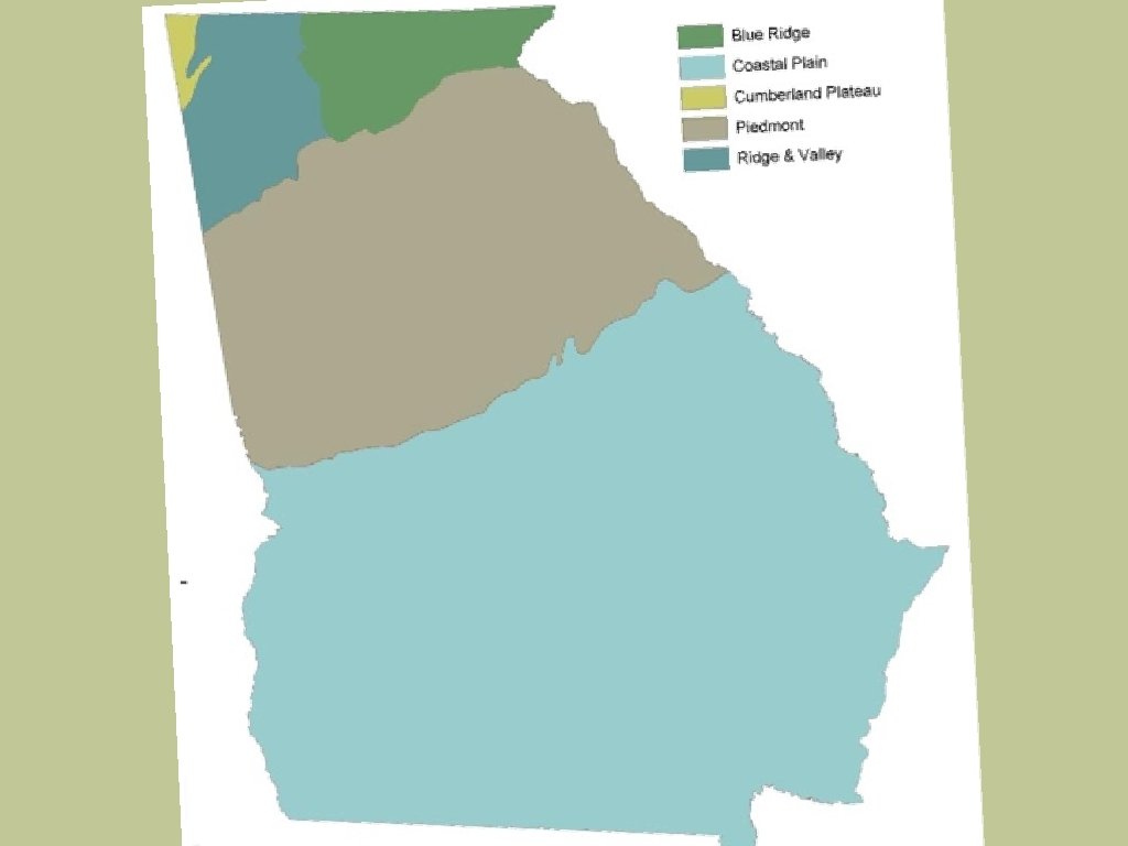
The Geography of Georgia Georgias Five Geographical Regions


- Slides: 20
The Geography of Georgia
Georgia’s Five Geographical Regions
Appalachian Plateau
Appalachian Plateau • Location: Northwest GA; known as the TAG corner because it touches Tennessee and Alabama • Physical Characteristics: Flat or gently sloping land surrounding valleys. • Interesting Features: Cloudland Canyon and Lookout Mountain
Appalachian Plateau • Climate: Cool winters and mild summer due to its higher elevation • Agriculture: Limited due to poor soil; however, some corn and soybeans are produced in this region • Economic Contribution: Tourism and forestry; production of coal and limestone; only known source of coal in GA
Ridge and Valley
Ridge and Valley • Location: Located in northern Georgia between the Appalachian Plateau and Blue Ridge regions • Physical Characteristics: Long, parallel ridges, separated by wide, fertile valleys • Interesting Features: Dalton, Georgia known as the “carpet capital of the world. ”
Ridge and Valley • Climate: Similar to Appalachian Plateau—cool winters and mild summers • Agriculture: Low valleys used as grazing pasture for livestock, and to grow crops such as soybeans, wheat, corn and cotton • Economic Contribution: Textiles and carpets
Blue Ridge
Blue Ridge • Location: Located in the northeast corner of Georgia. • Physical Characteristics: Has the highest elevation in Georgia and is home to Georgia’s highest peak, Brasstown Bald; Chattahoochee and Savannah Rivers originate in the Blue Ridge region
Blue Ridge • Interesting Features: Dahlonega, the home to the United States’ first gold rush • Climate: Coldest region; receives the most precipitation due to its elevation • Agriculture: Apples, corns, and vegetables; pastures home to large animals • Economic Contribution: Mining was a focus of its economy in the past; biggest industry for the Blue Ridge region is tourism
Piedmont
Piedmont • Location: Central part of the state; occupies approx. 30% of the land in the state; the Fall Line separates the Piedmont from Coastal Plain • Physical Characteristics: Gently rolling hills; location reflects its name (“foot of the hills”); home to several shallow rivers and red clay soil.
Piedmont • Interesting Features: 2 nd largest region; features urban cities of Atlanta, Columbus, Macon, and Augusta; contains over 50% of the state’s population • Climate: Warm/hot summers with cool winters; tornadoes can exact destruction in this region • Agriculture: Cotton, soybeans, wheat, poultry/eggs, hogs, cattle/beef
Piedmont • Economic Contribution: Highly industrialized; carpet milling, aircraft and automobile manufacturing, poultry processing
Coastal Plain
Coastal Plain • Location: Southernmost region in the state • Physical Characteristics: 60% of the state; largest region and is divided into two parts. q The Inner Coastal Plain is in the western part of the region. q The Outer Coastal Plain is in the eastern part of the region.
Coastal Plain • Interesting Features: The barrier islands protect mainland Georgia from hurricanes • Climate: Hot, steamy summers and cool winters • Agriculture: Peanuts, peaches, soybeans, cotton, Vidalia onions, pecans ©Nuttall. Social. Stu dies
Coastal Plain • Economic Contribution: Pulp and paper industry; commercial fishing and seafood processing; shipping (deep-water ports of Savannah and Brunswick)