The Forecast Funnel METR 2021 Lab 01 Materials
The Forecast Funnel METR 2021: Lab 01 Materials Adapted from The University of Georgia (http: //www. uga. edu/atsc/wxanal/help/forecastfunnel. htm)
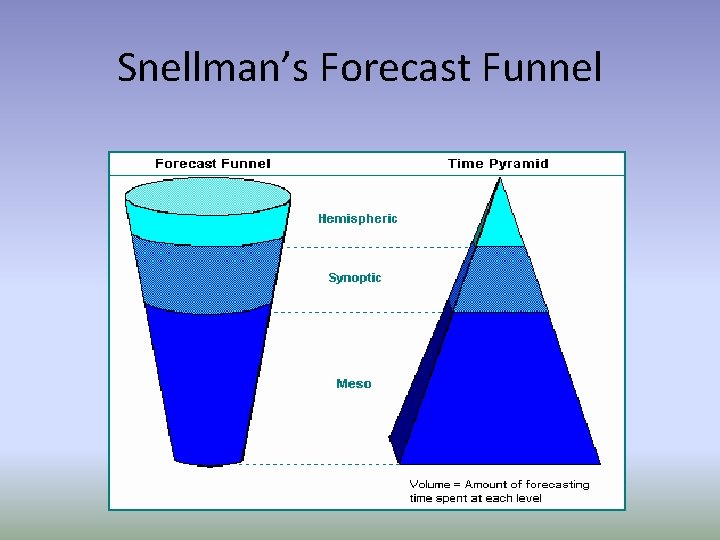
Snellman’s Forecast Funnel
Hemispheric • What is the hemispheric pattern and what effect will it have on my forecast? – What is the pattern of the westerlies? • Check 500 mb charts – How is the pattern evolving? • Progressive • Stationary • Regressive
Hemispheric Tools • • Constant Pressure Charts Satellite Animation Isallohypse Charts (500 mb) Departures from normal in height field
Synoptic • What is the problem of the day? – What and where are the “weather-producing” features? – How well do the numerical models represent these features? – How are the going to evolve? • Relate “features” to conceptual models – Frontal Models – Upper-Level Jet Structure – Baroclinic Leaf (satellite)
Synoptic Tools • Surface / Upper-Air analyses – Objective – Subjective • • • Satellite NWP (models) Soundings Wind Profilers (currently down) Regional Radar Animations / Lightning Data
Mesoscale • How does the mesoscale affect my problem of the day? – What is the direction and magnitude of the vertical motion? • Mesoscale convergence zones (radar) • Isentropic analyses • topography – Is the local airmass going to be wet or dry? • How extreme or benign will the weather in my forecast area be?
Mesoscale Tools • • • Doppler Radar Lightning Data Mesoanalysis Soundings Wind Profilers (currently down) Topography (also local scale)
FORECASTING TIME TABLE
0 to +6 hours (Nowcasting ) • Extrapolation of regional conditions and systems: – Thunderstorm Development – Fog Dissipation / formation – Time of clearing / clouding – Onset / Ending of precipitation • Rely upon remote sensing and mesoanalysis
+6 to +12 hours • Rely on combination of extrapolation and numerical guidance – Everything from previous slide – Precipitation development along front – Influence of shortwave trough entering region – Cloudiness Trend – Temperature Trend
+12 to +48 hours • Lean more on numerical guidance than extrapolation – Specific timing precipitation onset – Type of precipitation – Specific effects of a shortwave trough – Cold surge / heat wave – Movement of cyclones and anticyclones
+48 to +120 hours • Almost complete reliance on numerical guidance – Placement of surface systems / upper level features – General statements about • Temperature • Precipitation • Cloud cover • Teleconnections
+120 to +240 hours (5 -10 days) • Mainly use statistical / climatological models • Use numerical guidance to tweak – Above / Below average temperatures – Above / Below average precipitation • Teleconnections
10 days to 1 month • Almost entirely upon statistical / climatological models • Sometimes can use historical analogs • Teleconnections
Assignment • Over the next week pick a forecast period for somewhere in the lower 48 states and use the forecast funnel to make a forecast for the location that you picked. • Please select one or at most two maps from each scale of the funnel and embed the images in a single webpage. • On the page, please give a short description of the figure that you have included and at the end write a brief discussion of the forecast. • Finally, at the bottom of the images please give the forecast for the next two days for the chosen location. • You will not be graded on the accuracy of your forecast, but you will be graded on the quality of the image and whether or not it helps to explain the forecast being made.
- Slides: 16