
The evaluation Of GLI Land Higher Level Products

- Slides: 22
The evaluation Of GLI Land Higher Level Products Hirokazu YAMAMOTO JAXA/EORC Toshiaki HASHIMOTO JAXA/EORC Naoki YUDA RESTEC Mieko SEKI RESTEC Yasushi MITOMI RESTEC Hiroki YOSHIOKA Meijo Univ. Tamotsu IGARASHI JAXA/EORC
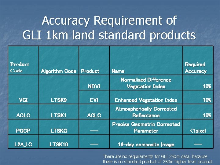
Accuracy Requirement of GLI 1 km land standard products Product Code VGI ACLC Algorithm Code Product LTSK 9 LTSK 1 Name Required Accuracy NDVI Normalized Difference Vegetation Index 10% EVI Enhanced Vegetation Index 10% ACLC Atmospherically Corrected Reflectance 10% <1 pixel --- PGCP LTSKG --- Precise Geometric Corrected Parameter L 2 A_LC LTSK 10 --- 16 -day composite Image There are no requirements for GLI 250 m data, because there is no standard product of 250 m higher level product.
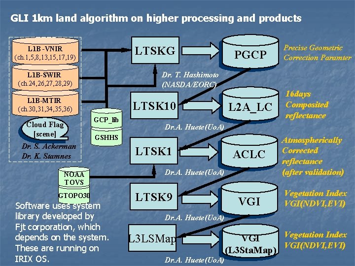
GLI 1 km land algorithm on higher processing and products LTSKG L 1 B -VNIR (ch. 1, 5, 8, 13, 15, 17, 19) Dr. T. Hashimoto (NASDA/EORC) L 1 B-SWIR (ch. 24, 26, 27, 28, 29) L 1 B-MTIR (ch. 30, 31, 34, 35, 36) LTSK 10 GCP_lib Cloud Flag [scene] PGCP Precise Geometric Correction Paramter L 2 A_LC Dr. A. Huete(Uo. A) GSHHS Dr. S. Ackerman Dr. K. Stamnes NOAA TOVS GTOPO 30 Software uses system library developed by Fjt corporation, which depends on the system. These are running on IRIX OS. 16 days Composited reflectance LTSK 1 ACLC Atmospherically Corrected reflectance (after validation) VGI Vegetation Index VGI(NDVI, EVI) Dr. A. Huete(Uo. A) LTSK 9 Dr. A. Huete(Uo. A) L 3 LSMap Dr. A. Huete(Uo. A) Vegetation Index VGI(NDVI, EVI) (L 3 Sta. Map)
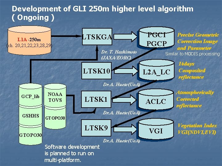
Development of GLI 250 m higher level algorithm ( Ongoing ) L 1 A -250 m (ch. 20, 21, 22, 23, 28, 29) LTSKGA PGCI PGCP Dr. T. Hashimoto (JAXA/EORC) LTSK 10 Precise Geometric Correction Image and Parameter Similar to MODIS processing L 2 A_LC 16 days Composited reflectance Dr. A. Huete(Uo. A) GCP_lib GSHHS NOAA TOVS LTSK 1 ACLC Atmospherically Corrected reflectance Dr. A. Huete(Uo. A) GTOPO 30 LTSK 9 GTOPO 30 Software development is planned to run on multi-platform. Dr. A. Huete(Uo. A) VGI Vegetation Index VGI(NDVI, EVI)
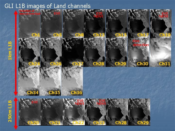
GLI L 1 B images of Land channels Detection of Aerosol over land Ch 1 EVI Ch 5 EVI NDVI Ch 8 Ch 13 EVI NDVI Ch 15 Ch 19 1 km L 1 B Fire detection Ch 24 Ch 34 250 m L 1 B Ch 17 Ch 26 Ch 35 Ch 21 Ch 28 Ch 29 Ch 30 Ch 28 Ch 29 Ch 36 EVI NDVI EVI Ch 20 Ch 27 Ch 22 EVI NDVI Ch 23 Ch 31
The Result of Evaluation
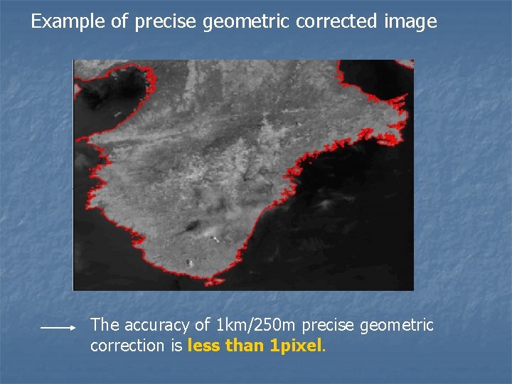
Example of precise geometric corrected image The accuracy of 1 km/250 m precise geometric correction is less than 1 pixel.
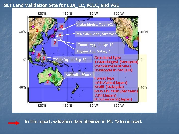
GLI Land Validation Site for L 2 A_LC, ACLC, and VGI 8 1 4 7 6 Nakashibetsu: 8/25~8/29 Mt. Yatsu:Apr. ( Automatic ) 3 Tottori:Apr. 14~Apr. 18 Togane:Aug. 5~Aug. 7 5 Mili:Sep. 11~Sep. 30 Australia: March 2 Grassland type 1: Mandalgovi (Mongolia) 2: Ambura(Australia) 3: Jornada in NM (US) Forest type 4: Mt. Yatsu(Japan) 5: Mili (Malaysia) 6: Ho Chi Minh (Vietnam) 7: Kii(Japan) 8: Tomakomai(Japan) In this report, validation data obtained in Mt. Yatsu is used.
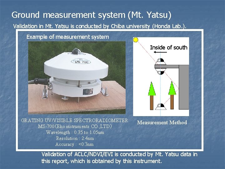
Ground measurement system (Mt. Yatsu) Validation in Mt. Yatsu is conducted by Chiba university (Honda Lab. ). Example of measurement system Inside of south GRATING UV/VISIBLE SPECTRORADIOMETER MS-700(Eko instruments CO. , LTD) Wavelength : 0. 35 to 1. 05 um Resolution : 2. 4 nm Accuracy : <0. 3 nm Measurement Method Validation of ACLC/NDVI/EVI is conducted by Mt. Yatsu data in this report, which is obtained by this instrument.
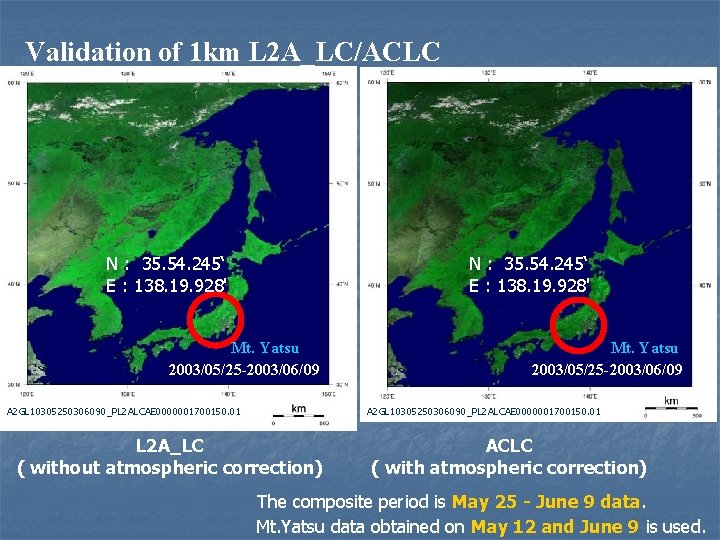
Validation of 1 km L 2 A_LC/ACLC N : 35. 54. 245‘ E : 138. 19. 928' Mt. Yatsu 2003/05/25 -2003/06/09 A 2 GL 10305250306090_PL 2 ALCAE 0000001700150. 01 L 2 A_LC ( without atmospheric correction) ACLC ( with atmospheric correction) The composite period is May 25 - June 9 data. Mt. Yatsu data obtained on May 12 and June 9 is used.
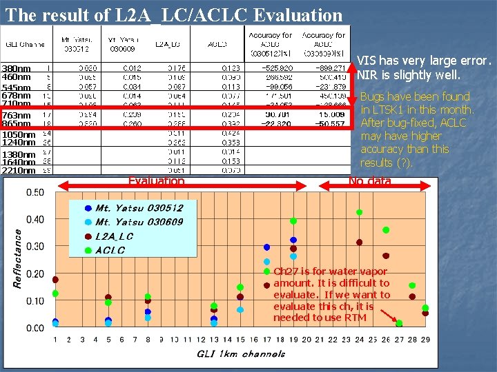
The result of L 2 A_LC/ACLC Evaluation 380 nm 460 nm 545 nm 678 nm 710 nm 763 nm 865 nm 1050 nm 1240 nm 1380 nm 1640 nm 2210 nm VIS has very large error. NIR is slightly well. Bugs have been found in LTSK 1 in this month. After bug-fixed, ACLC may have higher accuracy than this results (? ). Evaluation No data Ch 27 is for water vapor amount. It is difficult to evaluate. If we want to evaluate this ch, it is needed to use RTM
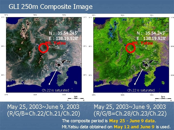
GLI 250 m Composite Image N : 35. 54. 245‘ E : 138. 19. 928' Mt. Yatsu Ch. 22 is saturated May 25, 2003~June 9, 2003 (R/G/B=Ch. 22/Ch. 21/Ch. 20) N : 35. 54. 245‘ E : 138. 19. 928' Mt. Yatsu Ch. 22 is saturated May 25, 2003~June 9, 2003 (R/G/B=Ch. 28/Ch. 23/Ch. 22) The composite period is May 25 - June 9 data. Mt. Yatsu data obtained on May 12 and June 9 is used.
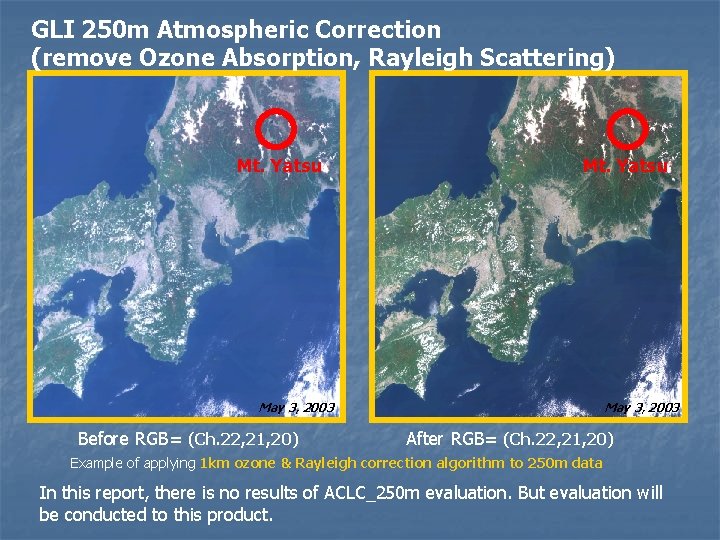
GLI 250 m Atmospheric Correction (remove Ozone Absorption, Rayleigh Scattering) Mt. Yatsu May 3, 2003 Before RGB= (Ch. 22, 21, 20) May 3, 2003 After RGB= (Ch. 22, 21, 20) Example of applying 1 km ozone & Rayleigh correction algorithm to 250 m data In this report, there is no results of ACLC_250 m evaluation. But evaluation will be conducted to this product.
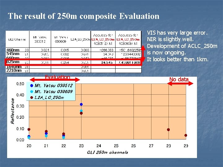
The result of 250 m composite Evaluation VIS has very large error. NIR is slightly well. Development of ACLC_250 m is now ongoing. It looks better than 1 km. 460 nm 545 nm 660 nm 825 nm 1640 nm 2210 nm Evaluation No data
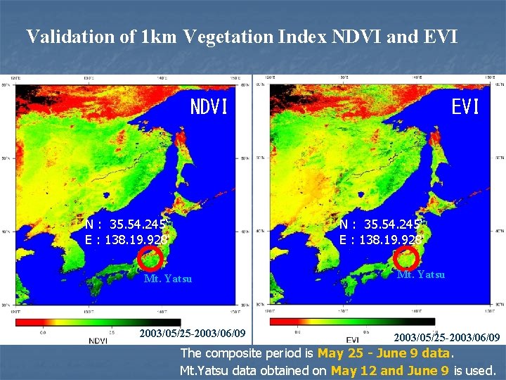
Validation of 1 km Vegetation Index NDVI and EVI NDVI N : 35. 54. 245‘ E : 138. 19. 928' EVI N : 35. 54. 245‘ E : 138. 19. 928' Mt. Yatsu 2003/05/25 -2003/06/09 The composite period is May 25 - June 9 data. Mt. Yatsu data obtained on May 12 and June 9 is used.
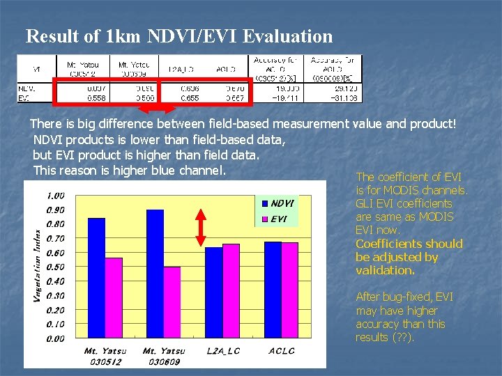
Result of 1 km NDVI/EVI Evaluation There is big difference between field-based measurement value and product! NDVI products is lower than field-based data, but EVI product is higher than field data. This reason is higher blue channel. The coefficient of EVI is for MODIS channels. GLI EVI coefficients are same as MODIS EVI now. Coefficients should be adjusted by validation. After bug-fixed, EVI may have higher accuracy than this results (? ? ).
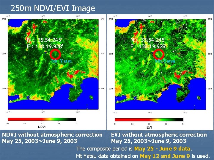
250 m NDVI/EVI Image N : 35. 54. 245‘ E : 138. 19. 928' Mt. Yatsu NDVI without atmospheric correction EVI without atmospheric correction May 25, 2003~June 9, 2003 The composite period is May 25 - June 9 data. Mt. Yatsu data obtained on May 12 and June 9 is used.
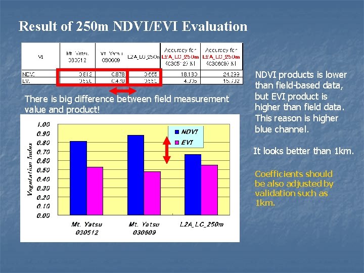
Result of 250 m NDVI/EVI Evaluation There is big difference between field measurement value and product! NDVI products is lower than field-based data, but EVI product is higher than field data. This reason is higher blue channel. It looks better than 1 km. Coefficients should be also adjusted by validation such as 1 km.
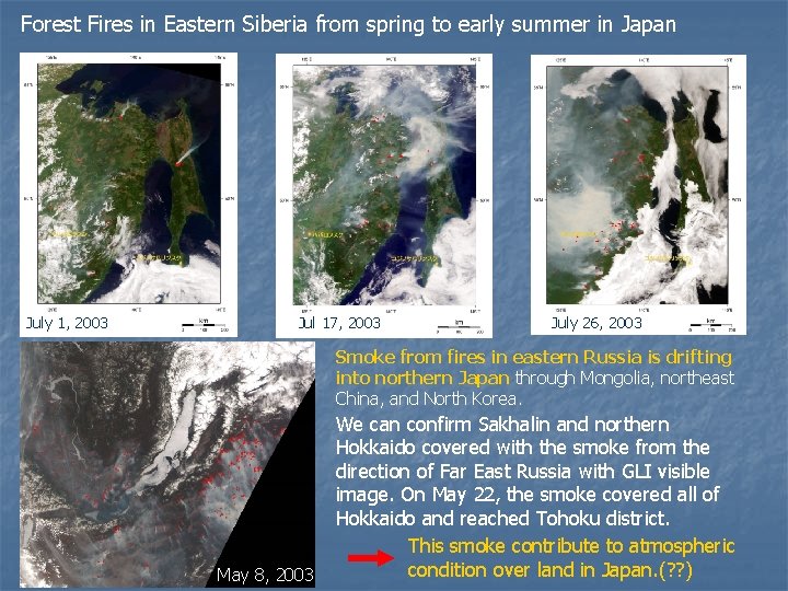
Forest Fires in Eastern Siberia from spring to early summer in Japan July 1, 2003 Jul 17, 2003 July 26, 2003 Smoke from fires in eastern Russia is drifting into northern Japan through Mongolia, northeast China, and North Korea. May 8, 2003 We can confirm Sakhalin and northern Hokkaido covered with the smoke from the direction of Far East Russia with GLI visible image. On May 22, the smoke covered all of Hokkaido and reached Tohoku district. This smoke contribute to atmospheric condition over land in Japan. (? ? )
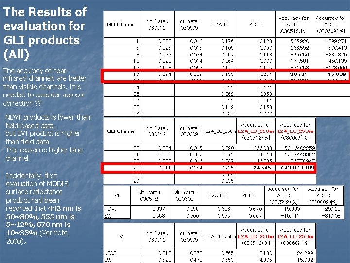
The Results of evaluation for GLI products (All) The accuracy of nearinfrared channels are better than visible channels. It is needed to consider aerosol correction ? ? NDVI products is lower than field-based data, but EVI product is higher than field data. This reason is higher blue channel. Incidentally, first evaluation of MODIS surface reflectance product had been reported that 443 nm is 50~80%, 555 nm is 5~12%, 670 nm is 10~33% (Vermote, 2000)。
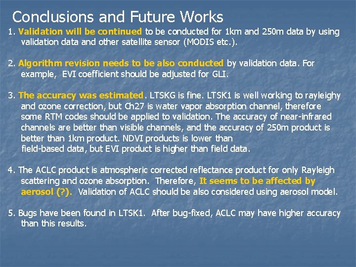
Conclusions and Future Works 1. Validation will be continued to be conducted for 1 km and 250 m data by using validation data and other satellite sensor (MODIS etc. ). 2. Algorithm revision needs to be also conducted by validation data. For example, EVI coefficient should be adjusted for GLI. 3. The accuracy was estimated. LTSKG is fine. LTSK 1 is well working to rayleighy and ozone correction, but Ch 27 is water vapor absorption channel, therefore some RTM codes should be applied to validation. The accuracy of near-infrared channels are better than visible channels, and the accuracy of 250 m product is better than 1 km product. NDVI products is lower than field-based data, but EVI product is higher than field data. 4. The ACLC product is atmospheric corrected reflectance product for only Rayleigh scattering and ozone absorption. Therefore, It seems to be affected by aerosol (? ). Validation of ACLC should be also considered using aerosol model. 5. Bugs have been found in LTSK 1. After bug-fixed, ACLC may have higher accuracy than this results.
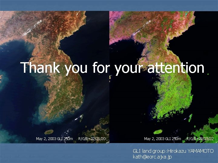
Thank you for your attention May 2, 2003 GLI 250 m R/G/B=22/21/20 May 2, 2003 GLI 250 m R/G/B=28/23/22 GLI land group:Hirokazu YAMAMOTO kath@eorc. ajxa. jp