The Essential Earth Chapter 3 PLATE TECTONICS The


 Seafloor Magnetic Anomalies • Heat at spreading centers melt mantle rocks")


- Slides: 30
The Essential Earth Chapter 3: PLATE TECTONICS: The Unifying Theory 22/10/2021 Copyright © 2007 by W. H. Freeman and Company
Plate Tectonics • How do plates form ? • Where do plates form ? • What is a plate ?
Plate Tectonics • What are the 3 types of plate boundaries ?
Divergent Boundaries Oceanic Plate Separation ica r e Am h t Nor Plate n Eur asia n Pla te • Plates form at mid-ocean spreading centers where rock melts, cools, and crystallizes • Each new plate moves symmetrically away from the spreading center increasing in thickness as it cools
Divergent Boundaries Continental Plate Separation ate l P an c i r f A Soma li Sub plate
Convergent Boundaries Ocean-Ocean Convergence Mariana Islands e n i p ip Phil e Plat Marianas Trench Pacif ic Pla te
Convergent Boundaries Ocean-Ocean Convergence Deep-sea trench; volcanic island arc. Mariana Islands e n i p ip Phil e Plat Marianas Trench Pacif ic Pla te
Convergent Boundaries Ocean-Continent Convergence Peru-Chile Trench te a l P a c Naz South American Plate
Convergent Boundaries Continent-Continent Convergence ate l P n a i l a r ust A n a i d n I Eurasian Plate
Mountain Belts Formed During Convergence • Mountain belts are chains of mountain ranges 1000 s of km long – Located along the edges of continents • As mountains grow higher and steeper, erosion rates increase (from running water and ice )
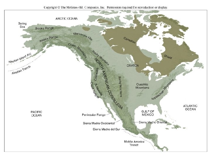
Continental Cratons • Ancient mountain belts have eroded nearly flat to form the stable core of a continent (craton or shield) • Every continental plate has a central, old, craton.
Volcanic Chains Cascadia Volcanic Line
Transform-Fault Boundaries Mid-Ocean Ridge Transform Fault Euras ia n Plat e m A h t r o N e t a l P n erica
Transform-Fault Boundaries Continental Transform Fault te a l P c i f Paci North Ameri can Pl ate
Transform-Fault Boundaries Continental Transform Fault – San Andreas As plates move past each other. . . …creek beds are offset
Transform-Fault Boundaries Continental Transform Fault – San Andreas As plates move past each other. . . San Francisco n Sa as re nd A …creek beds are offset fau Los Angeles lt
Magnetic mapping can measure the rate of seafloor spreading An oceanic survey over the Reykjanes Ridge, part of the Mid-Atlantic Ridge southwest of Iceland, showed an oscillating pattern of magnetic field strength. This figure illustrates how scientists worked out the explanation of this pattern. Mid-Atlant ic High inten sity Low intens ity Ridge
Magnetic mapping can measure the rate of seafloor spreading An oceanic survey over the Reykjanes Ridge, part of the Mid-Atlantic Ridge southwest of Iceland, showed an oscillating pattern of magnetic field strength. This figure illustrates how scientists worked out the explanation of this pattern. A sensitive magnetometer records magnetic anomalies, … Iceland Mid-Atlant ic High inten sity Low intens ity Ridge Mid. Atlantic Ridge Symmetrical bands on both sides. Why?
Mid-ocean ridge (original) Seafloor Magnetic Anomalies • Heat at spreading centers melt mantle rocks • Melting raises temperatures above the “Curie Temperature” 4. 0 Million 3. 0 years ago • The magnetic alignment of minerals is released 2. 0 Ocean crust today ion l l i m 5. 0 rs old yea 2. 5 3. 3 0. 7 0 0. 7 2. 5 3. 3 5. 0 • When the melt cools to form tectonic plates, the new rocks adopt the magnetic alignment of the Earth's current magnetic field. • The plate spreads away and starts the process again.
Magnetic Reversal Record Subchrons 5. 0 Ma 4. 0 Gilbert reversed chron 3. 0 Gauss normal chron 2. 0 1. 0 Matuyama reversed chron Present Brunhes normal chron
Review: Three Types of Plate Boundaries But how do we know that plates move at all ? Transform (strike-slip) Convergent (subduction) Divergent (spreading)
Early Case for Continental Drift: continental “shape” and “fit” • Puzzle-piece fit of coastlines of Africa and South America has long been known
Early Case for Continental Drift: fossils • In early 1900 s, Alfred Wegner noted South America, Africa, India, Antarctica, and Australia have almost identical rocks and fossils – Glossopteris (plant), Lystrosaurus and Cynognathus (animals) fossils on five continents – Mesosaurus (reptile) in Brazil and South Africa only
Early Case for Continental Drift: glaciers • Wegner reassembled continents into the supercontinent Pangaea • Late Paleozoic glaciation patterns on southern continents explained reconstruction into (Pangaea) Gondwanaland
Early Case for Continental Drift • Continental Drift hypothesis initially rejected – Wegener could not come up with viable driving force – continents should not be able to “plow through” sea floor rocks
The Earth's Magnetic Field Can Give Us Clues
Continental Drift: Paleomagnetism • Paleomagnetism magnetic minerals align and dip with Earth's internal magnetic field lines – Steeper dip angles indicate rocks formed closer to the magnetic poles • Rocks with increasing age point to pole locations increasingly far from present magnetic pole positions
Paleomagnetism and Continental Drift Revived • Apparent polar wander curves for different continents indicate plate movement ! • Wegner was right! • Plate Tectonics widely accepted by 1960's
Plate Tectonics and the Scientific Method How does an idea become a theory ? * When Wegner first suggest the idea of Plate Tectonics what was it ? a) theory b) hypothesis c) data d) proof * What data was later acquired to test this (name 5 lines of evidence) ? * When did plate tectonics become an accepted theory ? (What discovery proved the original predictions ? )