The Cultural Landscape Chapter 1 Basic Concepts Five

The Cultural Landscape Chapter 1 Basic Concepts

� Five Themes of Geography �Location- absolute and relative location. �Place- the distinctive physical and human characteristics of a place. �Human-Environmental Interaction- how people interact with their environment. �Movement the mobility of people, goods and ideas the patterns and change in human spatial interactions accessibility & connectivity of places. �Regions- an area that displays a selected criteria- one or more distinctive characteristics. (example- New England)

The Two Types of GEOGRAPHY • Physical Geography – – Topography Climate Flora and Fauna soil • Human Geography – – – Culture Population Economics Political Urban Agriculture 2

Geography? Geography is the study of where things are found on Earth’s surface and the reasons for their locations. � Human Geographers ask two simple questions… 1. Where are people and activities found on Earth? 2. Why are they found in these �

Geographers work with… MAPS! � � � A map is a two-dimensional or flatscale model of Earth’s surface, or a portion of it. Cartography is the science and practice of mapmaking. Maps serve two purposes… As a reference tool to identify an object’s absolute and relative location. 2. As a communications tool to convey the distribution of human activities or physical features. 1.

Early Mapmaking � � Earliest maps were reference tools—simple navigation devices to show a traveler how to get from one point to another. Early maps reflected the limits of knowledge and interaction in the era of their production
 He also")
First ‘world map’ was prepared by ERATOSTHENES (276– 194 B. C. ) He also coined the term GEOGRAPHY.

• Eratosthenes’ map reflected the limits of the world known by Greeks • Lands beyond Greek experience are nonexistent; the world is an island.

AL-IDRISI, 1154 ce This Muslim cartographer’s map reflected an expansion of geographic knowledge- and the recognition that not all of the world was ’known’

ORTELIUS, 1521 ce This Italian cartographer produced the first map depicting all of the world’s landmasses, influenced by reports from seagoing explorers.

Contemporary Mapping �Maps have shifted from being simply a tool that provides simple location reference to a tool used by geographers to communicate complex geographic phenomena.

PRINCIPLES OF MAPS AND MAPPING

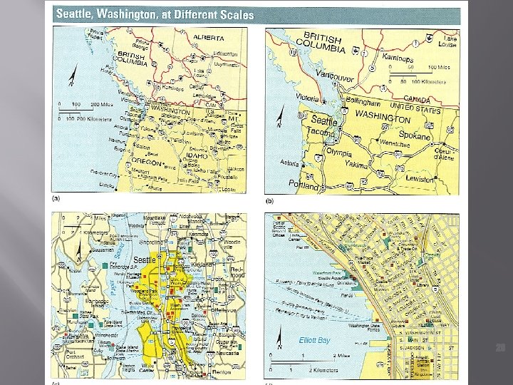
Map Scale � The level of detail and the amount of area covered on the map depend on its map scale. �Scale is the relationship of a feature’s size on a map to its actual size on Earth
 Ratio or Fraction Scale •")
Map scale is presented in three ways… 1. ) Ratio or Fraction Scale • Ex. 1: 24, 000 or 1/24, 000 • Number on left is one unit of distance on the map, while number on right represents its equivalent on Earth’s surface.

If a map has a scale of 1: 6000 and you measure a distance between objects of 5 Inches, how many inches would this represent on the Earth’s surface? How many feet would this
 Written Scale � Ex. 1")
Map scale is presented in three ways… 2. ) Written Scale � Ex. 1 inch equals 1 mile Number on left is a unit of measurement on the map, while that on right represents its equivalent on the surface of the Earth.
 Graphic Scale • Consists of")
Map scale is presented in three ways… 3. ) Graphic Scale • Consists of a bar marked on the map to show equivalent distance on the Earth’s surface
 maps show a large")
� LG v. SM Scale Small scale (or small fraction) maps show a large area on the earth such as 1/1, 000. �Less Detail � Large scale (or large fraction) maps show a small area on the Earth such as 1/25, 000 or 1/1000.

Projection The scientific method of depicting Earth’s round surface to a flat map is called projection. � Earth’s spherical shape becomes distorted when rendering it on a flat piece of paper. � �The shape, distance, relative size, and direction in maps can be impacted by distortion

In order to counter the impact of distortion, cartographers have created several different MAP PROJECTIONS. ONLY a globe lacks distortion. ALL flat maps are distorted in one way or

Wherecan a country is depictedits relative How a WORLD MAPand convey the size – is a controversial aspect of POWER or INFLUENCE of a mapmaking. This Australian map is radically particular country? different from those we know.

Geographic Grid � Geographic grid is a system of imaginary arcs drawn in a grid pattern on Earth’s surface. �MERIDIANS (lines of LONGITUDE) Run North/South from pole to pole. Values range from 0º (prime meridian) to 180º east or west longitude (Int’l Date Line) �PARALLELS (Lines of LATITUDE) run East/West parallel to the equator from 0º (@ equator) to at 90º @ north/south poles.
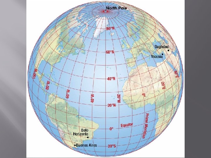

Geographic Grid, cont’d � Points on Earth’s surface can be communicated by referencing intersections of latitude and longitude. �Ex: Denver, Colorado’s location is 40º north latitude and 105º west longitude (40ºN/105ºW)

Telling Time Using the Globe � � � The Earth is divided into 24 ‘time zones, ’ each 15º longitude wide �Location in a certain time zone determines what ‘time’ it is relative to other places on Earth. The Prime Meridian, located at 0º Longitude, is the basis for the time system. Others are either ‘ahead’ or ‘behind’ this line. Because this line runs through Greenwich, England, it is called Greenwich Mean Time (GMT).

• We are in the EASTERN TIME ZONE, and are 5 HOURS BEHIND (GMT -5). • When it is 12: 00 pm here, it is 5: 00 pm in Greenwich, England

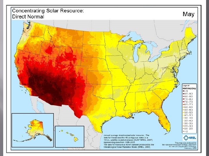
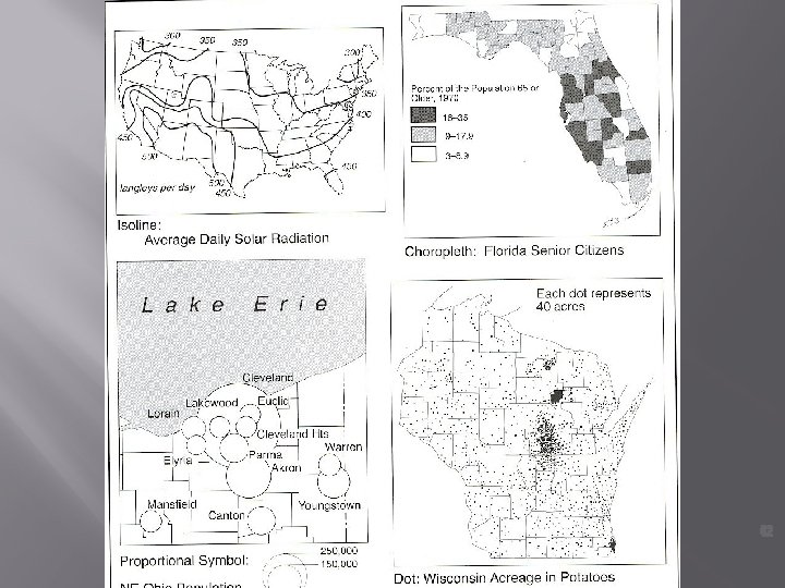
Thematic Maps – Not in Book �Isoline Maps- use lines of equal value to represent data like elevation, barometric pressure or

ISOLINE MAPS

ISOLINE MAPS

Choropleth Mapsmaps in which a specific variable is depicted with shading, patterns, or colors.

Chloropleth maps

Chloropleth maps

Proportional Symbolmaps in which the size of the symbol varies in proportion to the intensity of the mapped variable.

Proportional Symbol Maps

Proportional Symbol Maps

Dot Map- a thematic map in which a dot represents some frequency/occurre nce of the mapped

Dot Map

Cartogrammaps using relative size of political units to convey a

Cartograms
 is the collection/analysis of data acquired by satellites")
Contemporary Mapping Geographic Information Science (GIScience) is the collection/analysis of data acquired by satellites and other electronic technologies; this is called REMOTE SENSING �

GPS is one of the most impressive aspects of modern mapping. It uses a constellation of satellites to determine the ABSOLUTE (Lat. /Long. ) location of any object on Earth’s surface.
 is a computer")
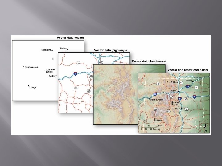
Contemporary Tools � Layering Data: GIS �A geographic information system (GIS) is a computer system that captures, stores, queries, analyzes, and displays geographic data. �Data are stored in layers. �Layers can be compared to show relationships among different kinds of information. �Data can be overlaid in one GIS from a variety of different sources through a process known as a mashup.

� � GIS Geographic Information Systems Layers of maps to describe many levels of information on a location.
- Slides: 47