THE COQUILLE RIVER TIDEGATE INVENTORY BY THE COQUILLE

THE COQUILLE RIVER TIDEGATE INVENTORY BY: THE COQUILLE WATERSHED ASSOCIATION Project funded by: Wild Rivers Coastal Alliance Oregon Watershed Enhancement Board
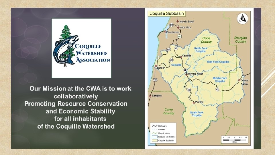

Types Of Watershed Restoration Projects We Do: Riparian Restoration o Native trees & shrubs planting o Invasive weed reduction o Watershed Restoration Projects/Working Lands Improvement o Livestock-exclusion fencing o Off-channel water systems Sediment Reductions o Erosion Control o Road Decommissioning o Improved heavy use areas Passage/Barrier Improvement o. Culverts o. Tidegates Instream Structures o. Large wood placement o. Rock weirs o. Spawning gravels Off-Channel Habitat o. Side channels o. Pools & Alcoves These actions will benefit not only fish, but all plants and animals and help to restore local eco-systems of working landscapes and diversity in fish runs, which will hopefully lead to eventual de-listing and greater recreational of commercial fishing opportunities

TIDEGATES SYSTEMS IN THE COQUILLE WATERSHED

2013 -2014 Tidegate & permitting assistance becomes hot topic 2014 The CWA meets with the WRCA and discusses the need for an inventory to convey the need to address failing infrastructure as well as try to find a way to assist landowners with working landscape issues such as permitting Funding was approved for the CWA to locate as many structures as possible Survey work was completed in 2015 with 114 structures 2015 - current The Nature Conservancy also received funding to from WRCA to work with the CWA and convert finding to useful information including a prioritization list
The project produced a comprehensive survey")
The Coquille Tidegate/Water Control Structure Inventory Project Purpose: 1)The project produced a comprehensive survey of tidegates in the Coquille River system. 2)The project will also increase community awareness about tidegates, landowner outreach could possibly lead to riparian and/or large wood projects once landowners are aware of options for restoration and the enhancement of their properties and working landscapes. *We will be able to work with partners to prioritize the structures *Use data to appeal to and secure funders for on-the-ground restoration projects. *Further research and provide data on how lower wetland tidally-influenced areas with brackish waters are a key migration tool for developing and over- wintering fry/salmonids to acclimate from fresh water to the ocean, and improving that habitat by replacing failing/non-functioning tidegates and culverts with fish-friendly tidegates will lead to healthier and more abundant fish populations.

Process Overview: *Preliminary Research & Preparation- search for and review existing tidegate information, tax lot owner info etc. *Inventory & Assessment- Survey approximately 37. 5 miles of river by boat. Contact landowners and survey by land. *Inventory Report- Compile collected data, meet with partners for assessment, feasibility and assist with priority rankings. *Project Development- Begin developing outreach and projects with willing landowners.

PRELIMINARY RESEARCH & PREPARATION § Mattison tidegate study 2011 § § ODFW fish barrier layer § § OFPB_NHD_Publication 20141114. gdb Review of tax lot layers along waterways § § Approximately 36 listed tidegate. Coos County/Assessors /Map Information/GIS Parcel Interactive web map Review of GIS mapping and crossing points. § Arc GIS map imagery-CWA § Google Earth

Mattison GPS points converted to GIS map
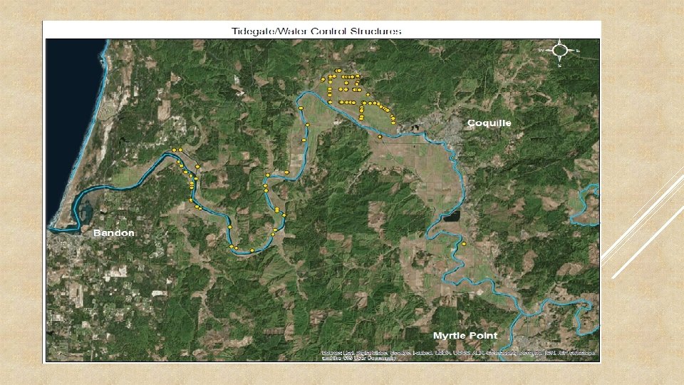

INVENTORY RESULTS Ø 114 structures found along the 37 miles of river as well as on private land where permission was granted. Ø 59 (52%) were 2 feet or less Ø 32 (28%) were 2 -5 feet Ø 10 (9%) were 6 -8 feet Ø 5 (7%) were 6 feet or larger Ø 4 (4%) were unknown Observations indicated: Ø 28 (25%) Considered fully functioning for working landscape needs Ø 11 (10%) Considered partially functioning with leaks Ø 12 (11%) Considered not in functioning condition Ø 63 (56%) unknown condition-not able to verify or not permission to access Ø Fish passage % by ODFW standards is unknown at this time, some are on the ODFW barrier list.

EXAMPLE SITE 13: *WILL SHOW VARIOUS DATA COLLECTED *PICTURES AND SITE DESCRIPTION/OBSERVATION *EXAMPLE OF POSSIBLE HABITAT IMPROVEMENTS WITH THE HELP OF TNC PRIORITY RANKING PROCESS WE WILL HAVE ADDITIONAL DATA OF HOW THE PROJECT RANKS OVERALL, POTENTIAL ACRES OF HABITAT BEHIND THE GATE, POTENTIAL DATA FOR CONCEPTUAL PROJECT COST ESTIMATE.

Lat & Long 124. 16. 4 93 43. 10. 44 94 124. 16. 3 95 43. 10. 95 10 6 124. 16. 3 95 43. 10. 95 10 B 6 124. 16. 643 43. 11 11. 518 Approx. River Survey Mile method 16. 8 Boat & 17. 8 Land Boat & 18. 65 Land Tidegate Primary Secondary or crossing Primary Crossing Type Condition Notes Appears workingcurrently closedpossibly Unknown Roundmetaltop hinge leaking brand CMP Size ft. Type 3 124. 17. 7 74 43. 09. 25 13 4 20. 3 Boat Primary Boat & 14. 99 Land Primary 3 6 x 6 Metal hangerswooden flaps Appear to be Unknown maintaine brand, d and possibly concreteworking leaks square 50 4 x 4 Wooden flap w/ pet door 124. 25. 9 49 43. 11. 53 12 8 124. 15. 5 96 43. 11. 74 6 Water 1 st ACW 2 nd ACW 3 rd ACW depth at Upstream at at 20' upstream width @ upstream above structure widthx 10 first second Size ft. Condition / inlet Home madegate on concrete/ Out of alignment each end corrigatede - leaking of pipe - round Chained partially openpetdoor brokehomema leaking de 4 Appears good at tidegate. No acess to inside Appears clear and functionin g- No acess to inside **Appear s to be concrete on one end and corrigate s on the other. Water depth at Downstre 1 st ACW down am width at down stream/ @ stream outlet structure widthx 10 Tidal Rivers Edge ODFW 2 nd ACW 3 rd ACW ODFW identified at 20' identified tidegate below Channel presence as first second Name ? barrier? No distance/ type to next barrier Potential habitat in all tris to next barriers 3. 77 No 5 30 Tidal 60 Assumed No unknown 5 30 Tidal 60 same yes unknown 4. 6 miles 3. 75 Tidal 10 Appears workingtop hinge currently closed. Aluminu possibly m leaking Rectangl e gate on round culvert structure CMP-round 8 Appears clear and functionin gcrossing is stable and retaining wall good Appears clear and 2 11. 5 14. 2 13. 8 10. 8 Tidal 20 daylight @115' 0 Hatchet 0 Slough yes

#13 river mile 14. 4 is a primary tidegate/water control structure. Tidegate appears to be functional, possible minor leaking. While considered functional to the landowner this could be considered a full fish barrier depending on operation management. Based on GIS map and ODF fish layer improvement to operation management or replacement with fish friendlier gate could improve fish access to approximately 4. 6 miles of habitat.

ODFW Current and historical fish habitat indicated by yellow line behind barrier 13. Measured out to Approximately 4 miles of potential improved habitat access.
 2, 508 Ac (3. 9 sq. miles) of watershed 4")
SITE 13 (HATCHET SLOUGH) 2, 508 Ac (3. 9 sq. miles) of watershed 4 miles of coho habitat per ODFW layer 18. 7 miles of stream network 34. 7 ac of inundation area 1 know barrier at this time (tidegate)

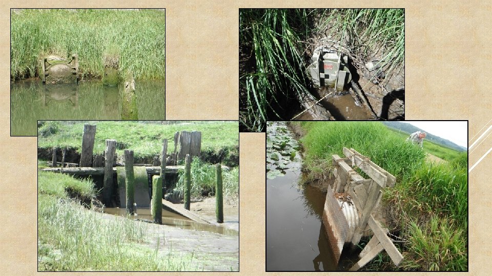
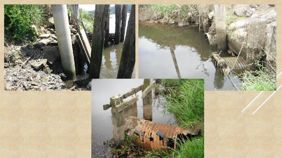
Various Pictures of Structures

Biggest Project Challenges Landowner may not be open to Federal, State or other regulatory agency involvement Project funding Lack of project development funds Funding match sources Funding timelines (1 or 2 yrs. ) Permitting Complexity of information required length of time to process Associated use restrictions or requirements

NEXT STEPS: *CONTINUE WORKING WITH TNC STAFF TO USE DATA TO COMPLETE PRIORITIZATION *CONTINUE WORKING WITH ODFW TO ASSIST WITH PRIORITIZATION *CONTINUE LANDOWNER AND AGENCIES PROJECT DEVELOPMENT (3 IN PROCESS) *CONTINUE TO SEEK AND OBTAIN FUNDING *CONTINUE TO WORK WITH PERMITTING AGENCIES TO STREAMLINE PERMITTING PROCESS UNDER CERTAIN CONDITIONS (PROGRAMATIC) *IMPROVE PROJECT IMPLEMENTATION TIMELINES TO MEET WORKING LANDSCAPE NEEDS *SHARE WHAT WE HAVE LEARNED WITH OTHERS
- Slides: 21