The Concept of Development Geographic Space and Development


- Slides: 17
The Concept of Development Geographic Space and Development
Space As A Framework n Geographic Space provides framework for field of human action: distance and place distinction matter n Location is critical- location of objects and perception of objects and their location influence behavior n Spatial Structure- ordered relations between individual spatial forms and the whole of which they are a part
Puerto Rico Administrative Regions System of Regions with Regional and National Capital Elements: Farms, Villages, Cities , Networks
Spatial Organization Elements n n n If we use the idea of change and transformation of spatial structures- what is involved? 1. Spatial Competition- competing land uses in an evolving urban area or two transport networks competing for traffic 2. Spatial Integration- coordination of spatial activities to achieve harmony –networks 3. Spatial Diffusion- how something spreads over geographic space; vital mechanism to keep momentum of development alive a. involves innovations- acceptance of new goods and services by consumers and entrepreneurs
Spatial Competition: The Silk Road and the Arab Sea Routes ARABIA Muza Kané Aden Sur Barbaricon Calcutta Barygaza Arabian Sea INDIA Bay of Bengal Muziris Mogadishu Atl SOMALIA Guangzhou Indian Ocean Malacca tic an n ea Oc Mombasa 500 Miles JAVA Pacific Ocean Berenike Muscat CHINA Sea ea d. S Re EGYPT Hotan Bactra Lanzhou Xi’an ina Alexandria Antioch Hamadan Merv Rey Tyre Baghdad. PERSIA Gobi Desert Dunhuang Ch Mediterranean Ocean ea Athens Constantinople Turpan Samarkand Kashgar esert Bukhara an D k a im Takl So uth Black Sea ian S Casp EUROPE Rome
Spatial Integration: Roman Road Network, 200 AD Atlantic Ocean Black Sea Ad ria t ic S ea Mediterranean Ocean 500 km Re d Se a
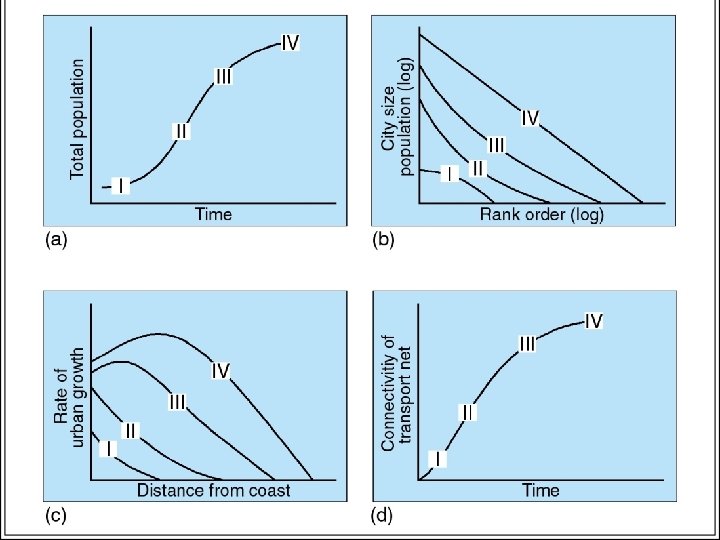
Model of Typical Spatial Development n n S I- simple ports S II- transport penetration S III- growth of interior cities S IV- merge of towns and high order transport
Ideal Typical Sequence of Network Development A B C D E F
Impacts of Integration Processes on Networks and Flows Before Integration Flows Network International border After Integration
Economic Production and Specialization Region B Region A Self Reliance Regional Trade International Trade and Transport Product A Product B Product C Product D Product E Gateway
Development As Spatial Reorganization n Need new set of spatial actions to achieve spatial goals n May involve new system of resource allocation which implies some efficiency n Certain spatial arrangements may be expected to create a better means to achieve national, regional and local goals
Growth Poles Theory: Deliberate Urbanization Growth Pole Key Industry Linked Industry Secondary Growth Pole Secondary Industry Linked Industry
Transport Corridors and the Regional Spatial Structure B A High Order Low Specialization and High. Low interdependency C Articulation Point Distribution
Growth Pole: Ciudad de Guayana n n n Why develop city here? Pulls population into less developed area Access to resources (iron ore, oil) Transport- river provides access for outlet to Caribbean and beyond Orinoco’s hydro-electricity potential powering industry is critical
Special Political Zones: Federal Territory of Brasilia n n Brazil – 180 mil but coastal concentrations dominate Disperse population by creating inland capital territory Political functions in separate area- others? Create other services, create employment and residential compounds
Super Multi-Media Corridor: Kuala Lumpur-Klang Corridor n n n Malaysia’s future development- draw foreign direct investment Provide sites for high tech businesses in Shah Alam Estate Broad band access with virtual university Access to KL Intl Airport Create employment and residential estates Manufacture electronic goods for export