The Cayman Islands 2012 Significant Weather Events 2012


- Slides: 17
The Cayman Islands 2012 Significant Weather Events
2012 Rainfall Pattern
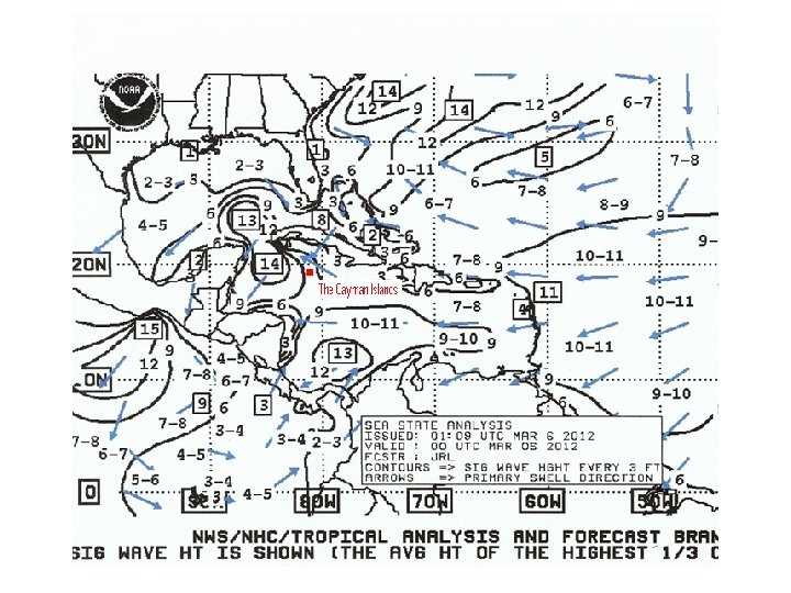
Strong Cold Front • • • A strong cold front moved across the Cayman area on the morning of March 5 th 2012. The system supported cloudiness and heavy showers with a rainfall accumulation of 3. 83 inches on March 4 th and 5 th. Fresh northeast winds and rough seas continued from March 6 th through March 8 th 2012 leading to the issuing of marine warnings being issued by the National Weather Service for the period.
Surface chart 1 am March 5 th 2012
Extremely Wet Month of April • An record April total of 7. 40 inches was recorded at the Owen Roberts International Airport for the month of April. • Traditionally the month of April is the driest of the year with a normal expected total of 1. 27 inches. • The rainfall total was 6. 13 inches more than the 30 year average and more than was received during the past 9 April’s. This was 583% more than expected. • The main producer of rainfall was a slow moving surface trough that moved across the Cayman area on April 26 -28 th 2012. The system supported 3. 68 inches of rainfall measured at the Owen Roberts International Airport.
Extremely Wet Month of May • Mid May is the usual start of the rainy season. May averages 5. 96 inches over the past 30 years. • A record May total of 17. 72 inches of rainfall was recorded. • The main producer was an area of disturbed weather that formed over the southwest Caribbean on May 17 th 2012. • The system then moved slowly to the northwest Caribbean by May 19 th 2012. • The National Weather Service began issuing flood advisories on May 20 th 2012. • Very heavy showers started on the night of May 20 th 2012 and the National Weather Service recorded 12. 92 inches of rainfall at the Owen Roberts International Airport from 7 p. m. May 20 th to 7 p. m. May 21 st 2012. • The very high rainfall total produced flooding across Grand Cayman. • The National Weather Service commenced issuing a Severe Weather Bulletin from 3 p. m. May 21 st 2012 and continued them through 10 a. m. May 23 rd 2012. • Similar conditions prevailed over the Sister Islands during the period but with lower rainfall totals. All schools were closed on Grand Cayman on Tuesday May 22 nd 2012 and on the Sister Islands the following day.
Tropical Storm Ernesto
Tropical Storm Ernesto CPA 180 miles South of Grand Cayman - Night of August 7 th , 2012.
Tropical Storm Ernesto • Weather charts indicate that Tropical Storm Ernesto passed within 180 miles south of Grand Cayman during the night of August 7 th 2012. • The Government of the Cayman Islands issued a Tropical Storm Watch for Grand Cayman on August 6 th. • 8 internal bulletins were issued between 5 -7 August 2012 • The system produced cloudiness and showers with an accumulation of 1. 39 inches measured at Owen Roberts International Airport on August 6 th 2012.
Hurricane Isaac
Tropical Storm Isaac CPA 236 miles Northeast Sister Islands -Night of August 25 th 2012.
Tropical Storm Isaac • Tropical Storm Isaac’s path took the system through the Windward Passage, north of Cuba within 236 miles to the northeast of the Sister Islands on the night of August 25 th 2012. • However the extensive cloud pattern and rain bands south of the center led to a Tropical Storm Watch being issued by the Government of the Cayman Islands on August 24 th 2012. • The storm produced cloudiness and heavy showers resulting in localized flooding with accumulations of 0. 58 of an inch on August 25 th, 4. 01 inches on August 27 th and 0. 60 of an inch on August 28 th 2012.
Hurricane Sandy
Hurricane Sandy CPA/229 miles east of the Sister Islands during the night of October 25 th 2012.
Hurricane Sandy • Storm formed over southwest Caribbean on October 22 nd 2012 and moved north-northeast. The storm passed within 229 miles east of the Sister Islands during the night of October 25 th 2012. • 11 internal bulletins issued between 10 pm October 22 nd to 4 pm October 25 th 2012 • Storm caused pressure gradient and wind speeds to increase over the northwest Caribbean and marine warnings were issued from October 22 -26 2012 • Wave heights reaching 8 -10 feet causing damage along north coast of the Sister Islands on October 25/26 th 2012 • Flood warnings issued for Sister Islands for October 24 th (1. 54 inches October 22 -26)
Debris Along North Coast Cayman Brac - By Large Waves - October 25/26, 2012