The AsianAustralian Monsoon System Recent Evolution Current Status
- Slides: 15

The Asian-Australian Monsoon System: Recent Evolution, Current Status and Prediction Update prepared by Climate Prediction Center / NCEP June 7, 2010 For more information, visit: http: //www. cpc. ncep. noaa. gov/products/Global_Monsoons/Asian_Monsoons. shtml 1

Outline • Recent Evolution and Current Conditions • Monsoon Prediction • Summary • Climatology 2

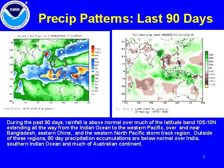
Precip Patterns: Last 90 Days During the past 90 days, rainfall is above normal over much of the latitude band 10 S-10 N extending all the way from the Indian Ocean to the western Pacific, over and near Bangladesh, eastern China, and the western North Pacific storm track region. Outside of these regions, 90 day precipitation accumulations are below normal over India, southern Indian Ocean and much of Australian continent. 3

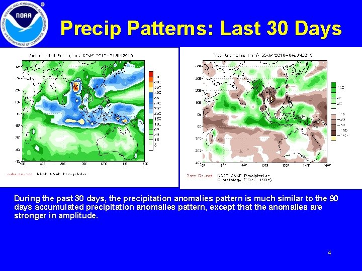
Precip Patterns: Last 30 Days During the past 30 days, the precipitation anomalies pattern is much similar to the 90 days accumulated precipitation anomalies pattern, except that the anomalies are stronger in amplitude. 4

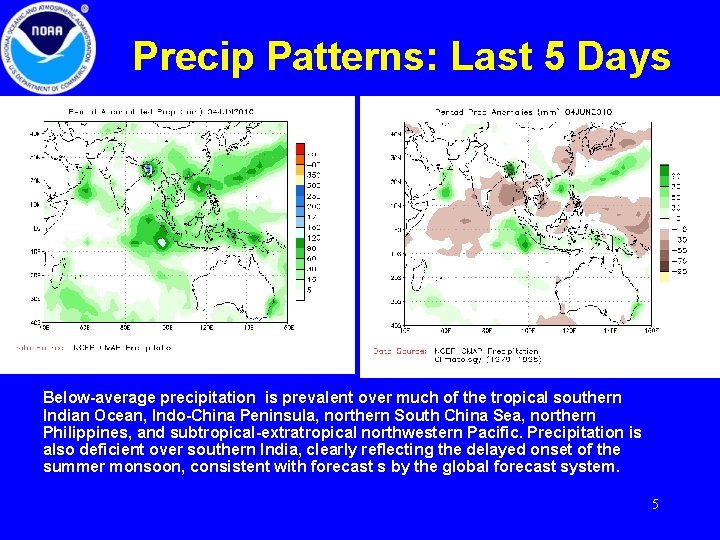
Precip Patterns: Last 5 Days Below-average precipitation is prevalent over much of the tropical southern Indian Ocean, Indo-China Peninsula, northern South China Sea, northern Philippines, and subtropical-extratropical northwestern Pacific. Precipitation is also deficient over southern India, clearly reflecting the delayed onset of the summer monsoon, consistent with forecast s by the global forecast system. 5

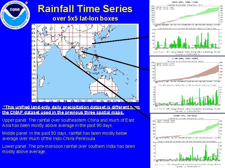
Rainfall Time Series over 5 x 5 lat-lon boxes *This unified land-only daily precipitation dataset is different from the CMAP dataset used in the previous three spatial maps. Upper panel: The rainfall over southeastern China and much of East Asia has been mostly above average in the past 90 days. Middle panel: In the past 90 days, rainfall has been mostly below average over much of the Indo-China Peninsula. Lower panel: The pre-monsoon rainfall over southern India has been mostly above average. 6

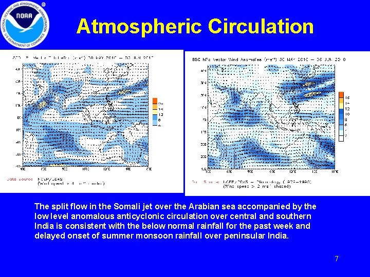
Atmospheric Circulation The split flow in the Somali jet over the Arabian sea accompanied by the low level anomalous anticyclonic circulation over central and southern India is consistent with the below normal rainfall for the past week and delayed onset of summer monsoon rainfall over peninsular India. 7

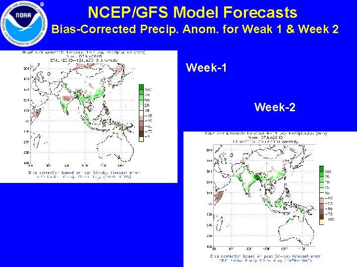
NCEP/GFS Model Forecasts Bias-Corrected Precip. Anom. for Weak 1 & Week 2 Week-1 Week-2 8

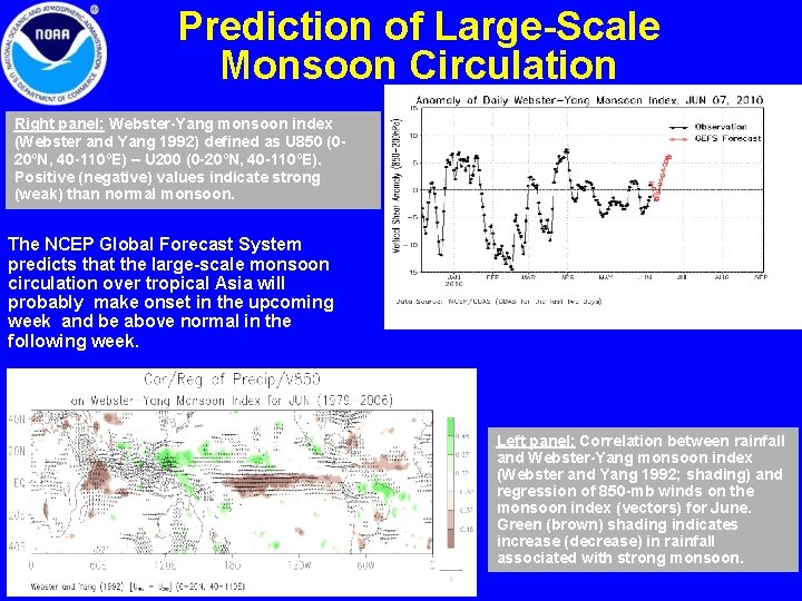
Prediction of Large-Scale Monsoon Circulation Right panel: Webster-Yang monsoon index (Webster and Yang 1992) defined as U 850 (020ºN, 40 -110ºE) – U 200 (0 -20ºN, 40 -110ºE). Positive (negative) values indicate strong (weak) than normal monsoon. The NCEP Global Forecast System predicts that the large-scale monsoon circulation over tropical Asia will probably make onset in the upcoming week and be above normal in the following week. Left panel: Correlation between rainfall and Webster-Yang monsoon index (Webster and Yang 1992; shading) and regression of 850 -mb winds on the monsoon index (vectors) for June. Green (brown) shading indicates increase (decrease) in rainfall associated with strong monsoon. 9

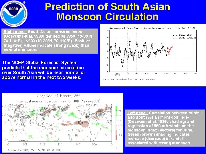
Prediction of South Asian Monsoon Circulation Right panel: South Asian monsoon index (Goswami et al. 1999) defined as v 850 (10 -30ºN, 70 -110ºE) – v 200 (10 -30ºN, 70 -110ºE). Positive (negative) values indicate strong (weak) than normal monsoon. The NCEP Global Forecast System predicts that the monsoon circulation over South Asia will be near normal or above normal in the next two weeks. Left panel: Correlation between rainfall and South Asian monsoon index (Goswami et al. 1999; shading) and regression of 850 -mb winds on the monsoon index (vectors) for June. Green (brown) shading indicates increase (decrease) in rainfall associated with strong monsoon. 10

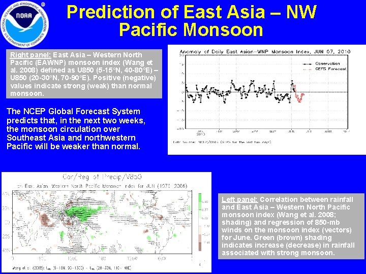
Prediction of East Asia – NW Pacific Monsoon Right panel: East Asia – Western North Pacific (EAWNP) monsoon index (Wang et al. 2008) defined as U 850 (5 -15ºN, 40 -80ºE) – U 850 (20 -30ºN, 70 -90ºE). Positive (negative) values indicate strong (weak) than normal monsoon. The NCEP Global Forecast System predicts that, in the next two weeks, the monsoon circulation over Southeast Asia and northwestern Pacific will be weaker than normal. Left panel: Correlation between rainfall and East Asia – Western North Pacific monsoon index (Wang et al. 2008; shading) and regression of 850 -mb winds on the monsoon index (vectors) for June. Green (brown) shading indicates increase (decrease) in rainfall associated with strong monsoon. 11

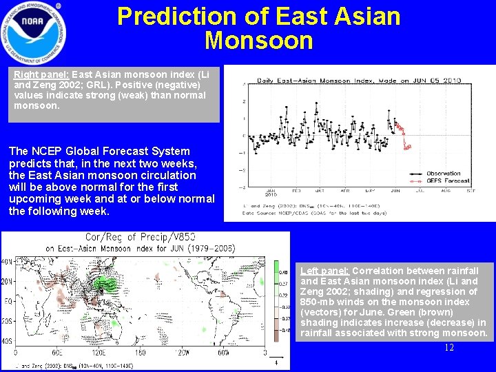
Prediction of East Asian Monsoon Right panel: East Asian monsoon index (Li and Zeng 2002; GRL). Positive (negative) values indicate strong (weak) than normal monsoon. The NCEP Global Forecast System predicts that, in the next two weeks, the East Asian monsoon circulation will be above normal for the first upcoming week and at or below normal the following week. Left panel: Correlation between rainfall and East Asian monsoon index (Li and Zeng 2002; shading) and regression of 850 -mb winds on the monsoon index (vectors) for June. Green (brown) shading indicates increase (decrease) in rainfall associated with strong monsoon. 12

Summary • During the past 90 days, rainfall is above normal over much of the latitude band 10 S-10 N extending all the way from the Indian Ocean to the western Pacific, over and near Bangladesh, eastern China, and the western North Pacific storm track region. Outside of these regions, 90 day precipitation accumulations are below normal over India, southern Indian Ocean and much of Australian continent. The past 30 days anomalies pattern is very similar to the 90 days pattern, except that the amplitude is stronger. • The NCEP Global Forecast System predicts that the summer monsoon onset over peninsular India is likely to be during the upcoming week and above normal during the second week of June. 13

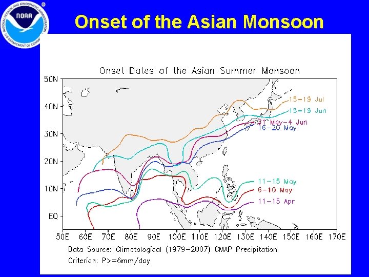
Onset of the Asian Monsoon 14

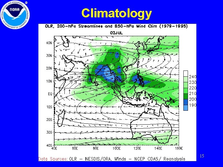
Climatology 15