The AsianAustralian Monsoon System Recent Evolution Current Status
- Slides: 15

The Asian-Australian Monsoon System: Recent Evolution, Current Status and Prediction Update prepared by Climate Prediction Center / NCEP August 29, 2011 For more information, visit: http: //www. cpc. ncep. noaa. gov/products/Global_Monsoons/Asian_Monsoons. shtml 1

Outline • Recent Evolution and Current Conditions • Monsoon Prediction • Summary • Climatology 2

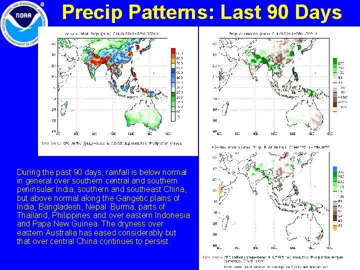
Precip Patterns: Last 90 Days During the past 90 days, rainfall is below normal in general over southern central and southern peninsular India, southern and southeast China, but above normal along the Gangetic plains of India, Bangladesh, Nepal Burma, parts of Thailand, Philippines and over eastern Indonesia and Papa New Guinea. The dryness over eastern Australia has eased considerably but that over central China continues to persist. 3

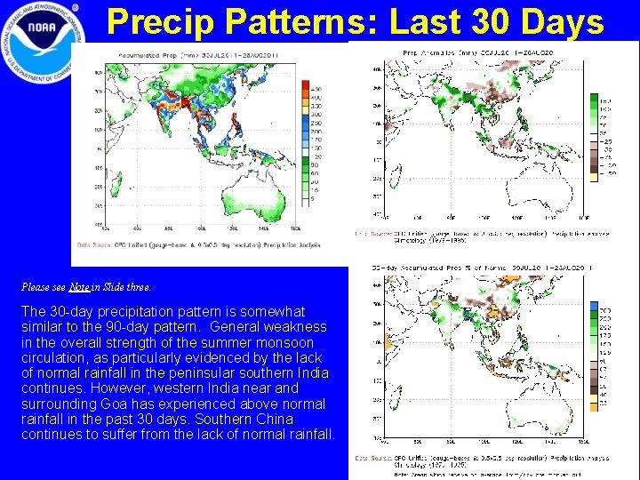
Precip Patterns: Last 30 Days Please see Note in Slide three. The 30 -day precipitation pattern is somewhat similar to the 90 -day pattern. General weakness in the overall strength of the summer monsoon circulation, as particularly evidenced by the lack of normal rainfall in the peninsular southern India continues. However, western India near and surrounding Goa has experienced above normal rainfall in the past 30 days. Southern China continues to suffer from the lack of normal rainfall. 4

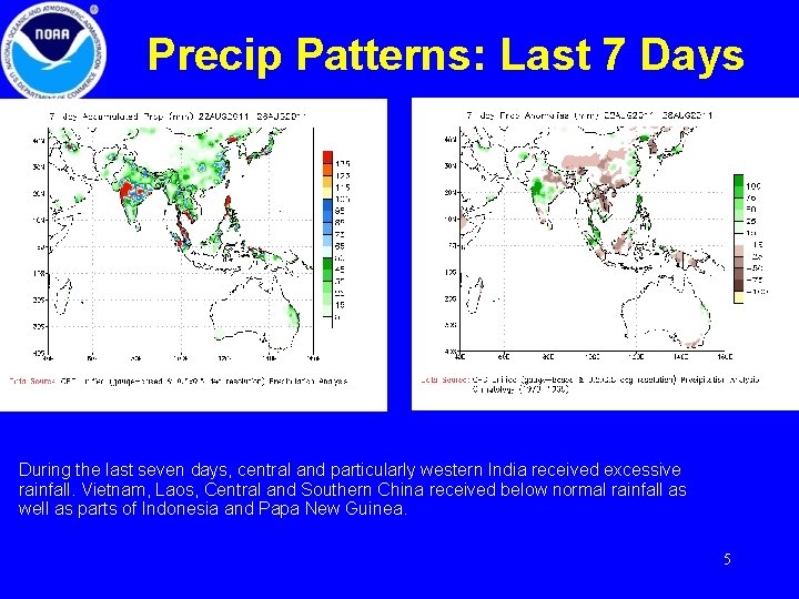
Precip Patterns: Last 7 Days During the last seven days, central and particularly western India received excessive rainfall. Vietnam, Laos, Central and Southern China received below normal rainfall as well as parts of Indonesia and Papa New Guinea. 5

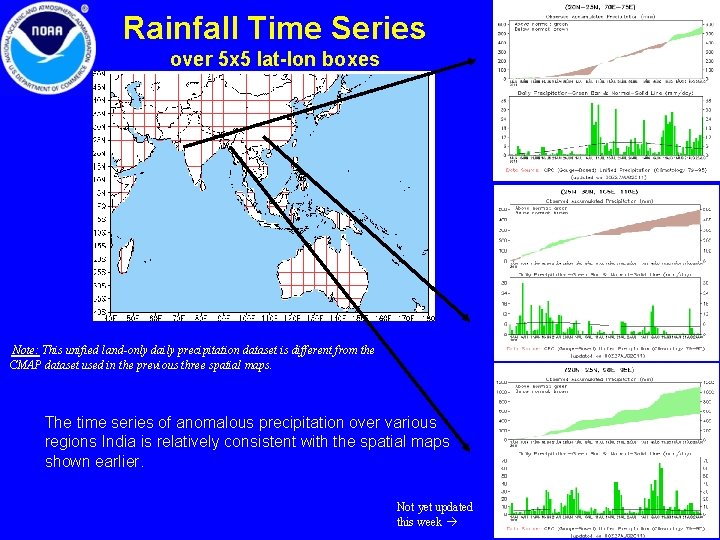
Rainfall Time Series over 5 x 5 lat-lon boxes Note: This unified land-only daily precipitation dataset is different from the CMAP dataset used in the previous three spatial maps. The time series of anomalous precipitation over various regions India is relatively consistent with the spatial maps shown earlier. Not yet updated this week 6

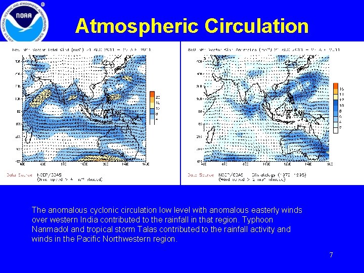
Atmospheric Circulation The anomalous cyclonic circulation low level with anomalous easterly winds over western India contributed to the rainfall in that region. Typhoon Nanmadol and tropical storm Talas contributed to the rainfall activity and winds in the Pacific Northwestern region. 7

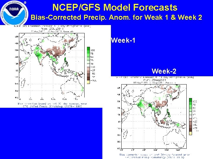
NCEP/GFS Model Forecasts Bias-Corrected Precip. Anom. for Weak 1 & Week 2 Week-1 Week-2 8

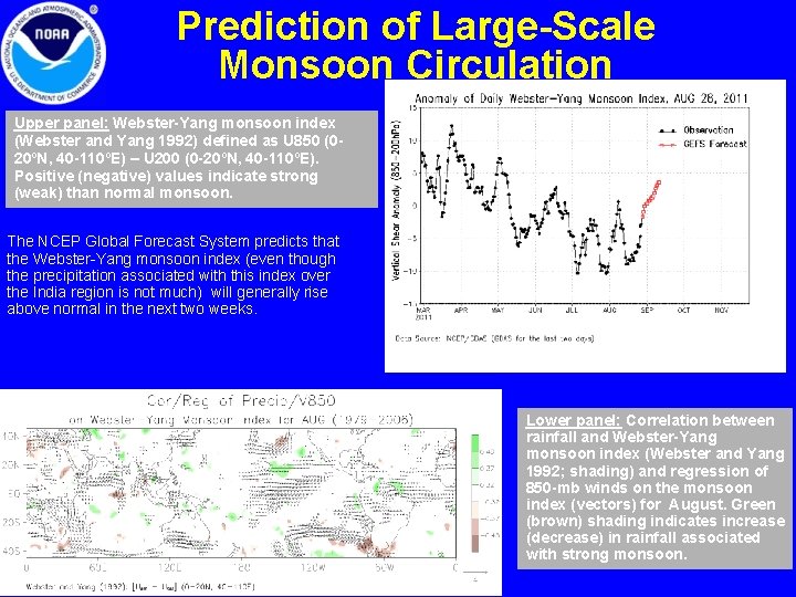
Prediction of Large-Scale Monsoon Circulation Upper panel: Webster-Yang monsoon index (Webster and Yang 1992) defined as U 850 (020ºN, 40 -110ºE) – U 200 (0 -20ºN, 40 -110ºE). Positive (negative) values indicate strong (weak) than normal monsoon. The NCEP Global Forecast System predicts that the Webster-Yang monsoon index (even though the precipitation associated with this index over the India region is not much) will generally rise above normal in the next two weeks. Lower panel: Correlation between rainfall and Webster-Yang monsoon index (Webster and Yang 1992; shading) and regression of 850 -mb winds on the monsoon index (vectors) for August. Green (brown) shading indicates increase (decrease) in rainfall associated with strong monsoon. 9

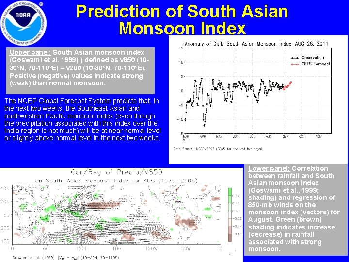
Prediction of South Asian Monsoon Index Upper panel: South Asian monsoon index (Goswami et al. 1999) ) defined as v 850 (1030ºN, 70 -110ºE) – v 200 (10 -30ºN, 70 -110ºE). Positive (negative) values indicate strong (weak) than normal monsoon. The NCEP Global Forecast System predicts that, in the next two weeks, the Southeast Asian and northwestern Pacific monsoon index (even though the precipitation associated with this index over the India region is not much) will be at near normal level or slightly above normal level in the next two weeks. Lower panel: Correlation between rainfall and South Asian monsoon index (Goswami et al. , 1999; shading) and regression of 850 -mb winds on the monsoon index (vectors) for August. Green (brown) shading indicates increase (decrease) in rainfall associated with strong 10 monsoon.

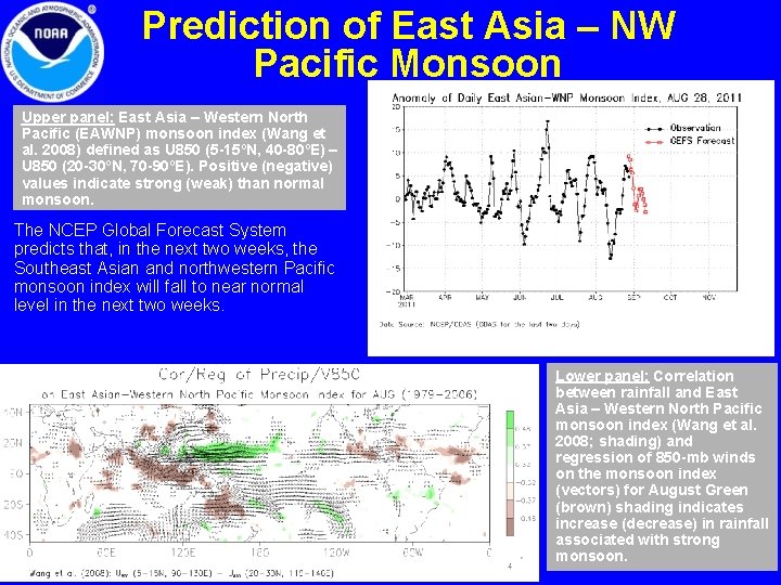
Prediction of East Asia – NW Pacific Monsoon Upper panel: East Asia – Western North Pacific (EAWNP) monsoon index (Wang et al. 2008) defined as U 850 (5 -15ºN, 40 -80ºE) – U 850 (20 -30ºN, 70 -90ºE). Positive (negative) values indicate strong (weak) than normal monsoon. The NCEP Global Forecast System predicts that, in the next two weeks, the Southeast Asian and northwestern Pacific monsoon index will fall to near normal level in the next two weeks. Lower panel: Correlation between rainfall and East Asia – Western North Pacific monsoon index (Wang et al. 2008; shading) and regression of 850 -mb winds on the monsoon index (vectors) for August Green (brown) shading indicates increase (decrease) in rainfall associated with strong 11 monsoon.

Summary • During the past 90 days, rainfall is below normal in general over southern central and southern peninsular India, southern and southeast China, but above normal along the Gangetic plains of India, Bangladesh, Nepal Burma, parts of Thailand, Philippines and over eastern Indonesia and Papa New Guinea. The dryness over eastern Australia has eased considerably but that over central China continues to persist. The 30 -day precipitation pattern is somewhat similar to the 90 -day pattern. General weakness in the overall strength of the summer monsoon circulation, as particularly evidenced by the lack of normal rainfall in the peninsular southern India continues. However, western India near and surrounding Goa has experienced above normal rainfall in the past 30 days. Southern China continues to suffer from the lack of normal rainfall. • During the last seven days, central and particularly western India received excessive rainfall. Vietnam, Laos, Central and Southern China received below normal rainfall as well as parts of Indonesia and Papa New Guinea. The anomalous cyclonic circulation low level with anomalous easterly winds over western India contributed to the rainfall in that region. Typhoon Nanmadol and tropical storm Talas contributed to the rainfall activity and winds in the Pacific Northwestern region. The NCEP GFS model continues to predict above normal rainfall over western India in the upcoming week. 12

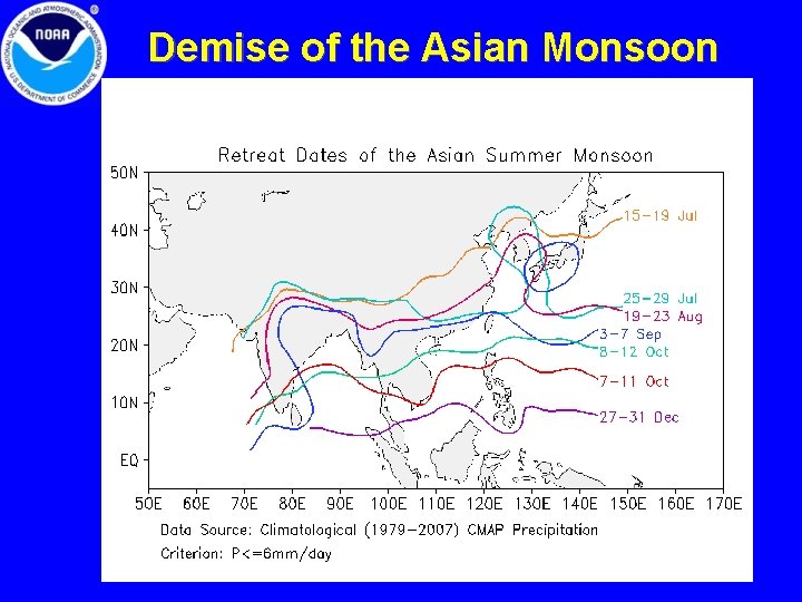
Demise of the Asian Monsoon 13

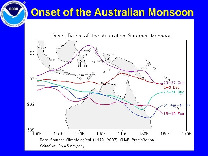
Onset of the Australian Monsoon 14

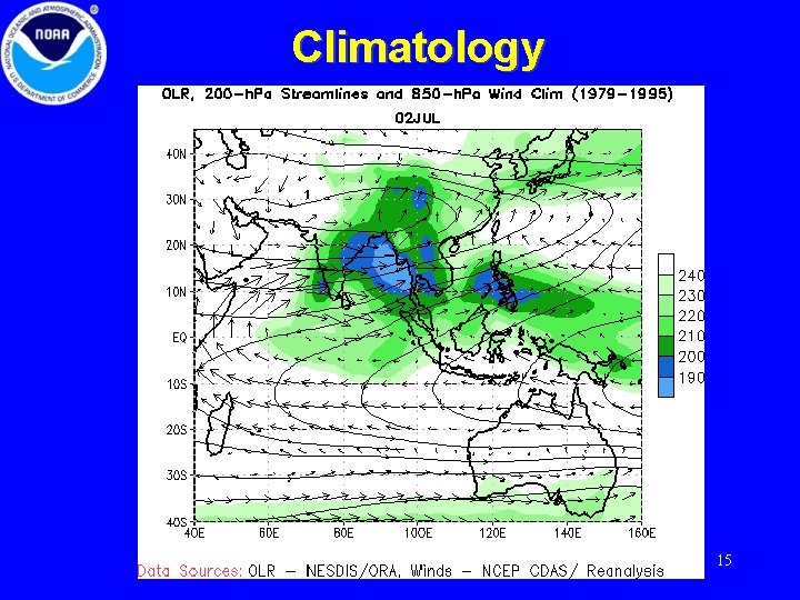
Climatology 15