The AsianAustralian Monsoon System Recent Evolution Current Status
- Slides: 13

The Asian-Australian Monsoon System: Recent Evolution, Current Status and Prediction Update prepared by Climate Prediction Center / NCEP 11 August 2008 For more information, visit: http: //www. cpc. ncep. noaa. gov/products/Global_Monsoons/Asian_Monsoons. shtml 1

Outline • Recent Evolution and Current Conditions • Monsoon Prediction • Summary • Climatology 2

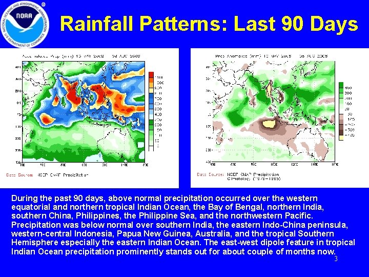
Rainfall Patterns: Last 90 Days During the past 90 days, above normal precipitation occurred over the western equatorial and northern tropical Indian Ocean, the Bay of Bengal, northern India, southern China, Philippines, the Philippine Sea, and the northwestern Pacific. Precipitation was below normal over southern India, the eastern Indo-China peninsula, western-central Indonesia, Papua New Guinea, Australia, and the tropical Southern Hemisphere especially the eastern Indian Ocean. The east-west dipole feature in tropical Indian Ocean precipitation prominently stands out for about couple of months now. 3

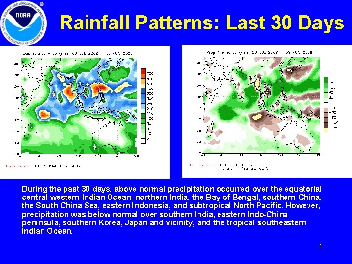
Rainfall Patterns: Last 30 Days During the past 30 days, above normal precipitation occurred over the equatorial central-western Indian Ocean, northern India, the Bay of Bengal, southern China, the South China Sea, eastern Indonesia, and subtropical North Pacific. However, precipitation was below normal over southern India, eastern Indo-China peninsula, southern Korea, Japan and vicinity, and the tropical southeastern Indian Ocean. 4

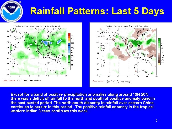
Rainfall Patterns: Last 5 Days Except for a band of positive precipitation anomalies along around 10 N-20 N there was a deficit of rainfall to the north and south of positive anomaly band in the past pentad period. The north-south disparity in rainfall over eastern China continues to persist in this period. The positive rainfall anomaly in the tropical western Indian Ocean continues this week. 5

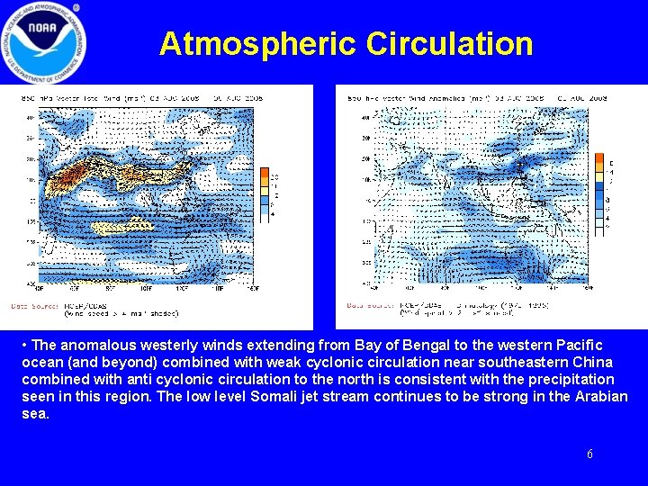
Atmospheric Circulation • The anomalous westerly winds extending from Bay of Bengal to the western Pacific ocean (and beyond) combined with weak cyclonic circulation near southeastern China combined with anti cyclonic circulation to the north is consistent with the precipitation seen in this region. The low level Somali jet stream continues to be strong in the Arabian sea. 6

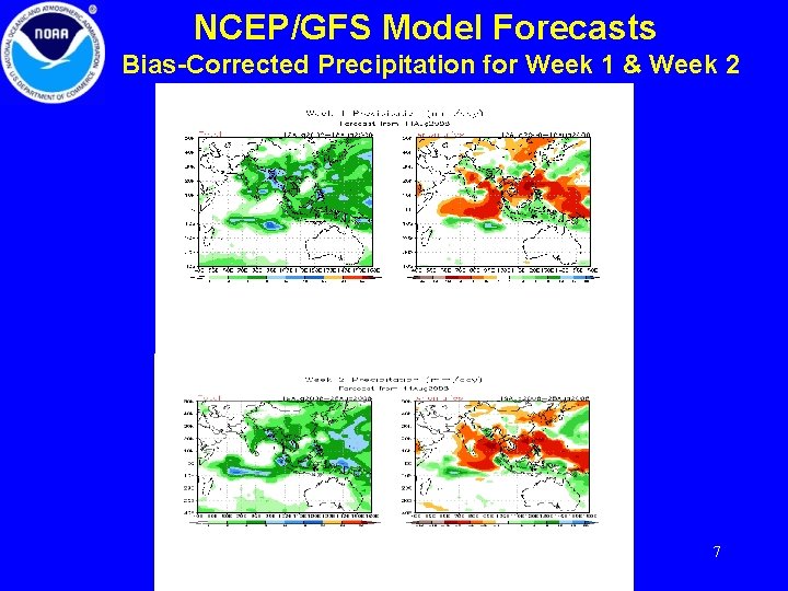
NCEP/GFS Model Forecasts Bias-Corrected Precipitation for Week 1 & Week 2 7

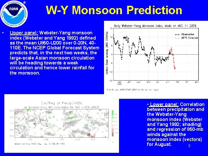
W-Y Monsoon Prediction • Upper panel: Webster-Yang monsoon index (Webster and Yang 1992) defined as the mean U 850 -U 200 over 0 -20 N, 40110 E. The NCEP Global Forecast System predicts that, in the next two weeks, the large-scale Asian monsoon circulation will be heading towards a weak circulation and hence lower rainfall for the monsoon. • Lower panel: Correlation between precipitation and the Webster-Yang monsoon index (Webster and Yang 1992; shading) and regression of 850 -mb winds against the monsoon index (vectors) for August. 8

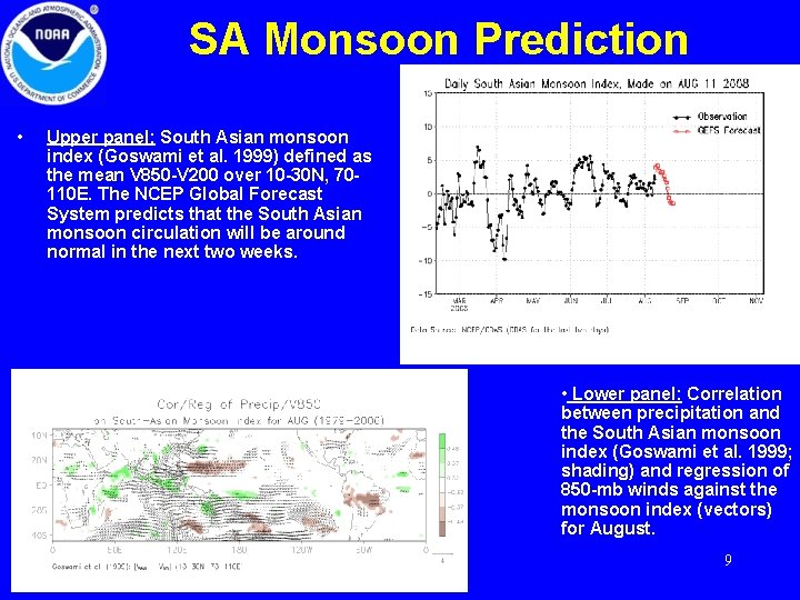
SA Monsoon Prediction • Upper panel: South Asian monsoon index (Goswami et al. 1999) defined as the mean V 850 -V 200 over 10 -30 N, 70110 E. The NCEP Global Forecast System predicts that the South Asian monsoon circulation will be around normal in the next two weeks. • Lower panel: Correlation between precipitation and the South Asian monsoon index (Goswami et al. 1999; shading) and regression of 850 -mb winds against the monsoon index (vectors) for August. 9

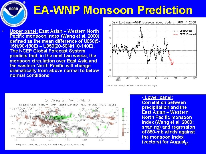
EA-WNP Monsoon Prediction • Upper panel: East Asian – Western North Pacific monsoon index (Wang et al. 2008) defined as the mean difference of U 850(515 N/90 -130 E) – U 850(20 -30 N/110 -140 E). The NCEP Global Forecast System predicts that, in the next two weeks, the monsoon circulation over East Asia and the western North Pacific will change dramatically from above normal to below normal conditions. • Lower panel: Correlation between precipitation and the East Asian – Western North Pacific monsoon index (Wang et al. 2008; shading) and regression of 850 -mb winds against the monsoon index (vectors) for August. 10

Summary • So far precipitation, for the 2009 summer monsoon season as a whole, exhibited markedly different characteristics over India and China. Over China, precipitation was below normal over northeastern China while it was above normal over southern China. But over India, northern India the accumulated monsoon rainfall so far this season was above normal while it was below normal in the south. There is a considerable deficit of monsoon precipitation so far over Bangladesh, Myanmar, and eastern Indo-China peninsula. • The prominent precipitation dipole in tropical Indian Ocean with rainfall maximum in the west and minimum in the east, which has anchored in the region and continues to persist for close to two months, continues to dominate the southwest monsoon in the south Asian region. • The NCEP GFS predicts that the large-scale Asian monsoon will hover around normal conditions for the next two weeks. 11

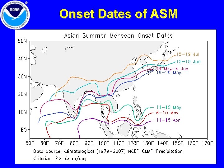
Onset Dates of ASM 12

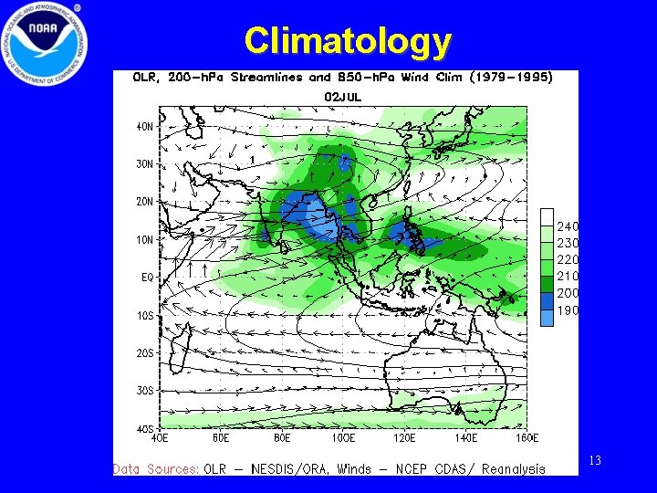
Climatology 13