The AsianAustralian Monsoon System Recent Evolution Current Status

- Slides: 14

The Asian-Australian Monsoon System: Recent Evolution, Current Status and Prediction Update prepared by Climate Prediction Center / NCEP 12 October 2008 For more information, visit: http: //www. cpc. ncep. noaa. gov/products/Global_Monsoons/Asian_Monsoons. shtml 1

Outline • Recent Evolution and Current Conditions • Monsoon Prediction • Summary • Climatology 2

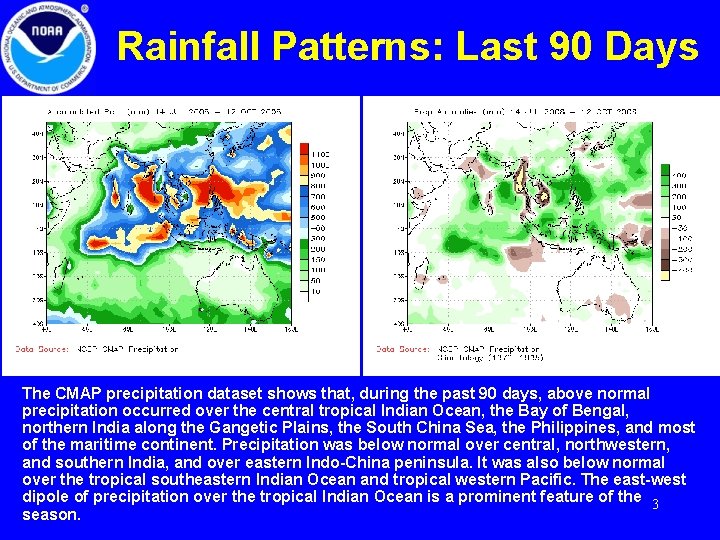
Rainfall Patterns: Last 90 Days The CMAP precipitation dataset shows that, during the past 90 days, above normal precipitation occurred over the central tropical Indian Ocean, the Bay of Bengal, northern India along the Gangetic Plains, the South China Sea, the Philippines, and most of the maritime continent. Precipitation was below normal over central, northwestern, and southern India, and over eastern Indo-China peninsula. It was also below normal over the tropical southeastern Indian Ocean and tropical western Pacific. The east-west dipole of precipitation over the tropical Indian Ocean is a prominent feature of the 3 season.

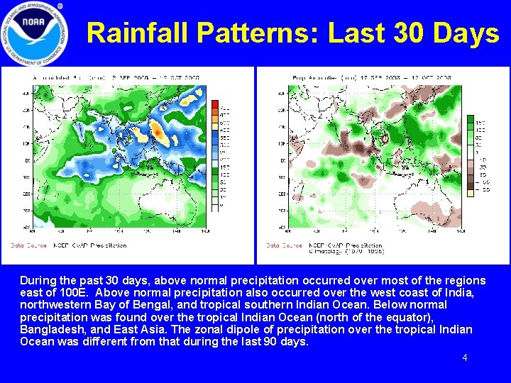
Rainfall Patterns: Last 30 Days During the past 30 days, above normal precipitation occurred over most of the regions east of 100 E. Above normal precipitation also occurred over the west coast of India, northwestern Bay of Bengal, and tropical southern Indian Ocean. Below normal precipitation was found over the tropical Indian Ocean (north of the equator), Bangladesh, and East Asia. The zonal dipole of precipitation over the tropical Indian Ocean was different from that during the last 90 days. 4

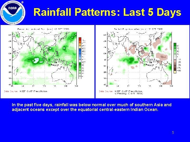
Rainfall Patterns: Last 5 Days In the past five days, rainfall was below normal over much of southern Asia and adjacent oceans except over the equatorial central-eastern Indian Ocean. 5

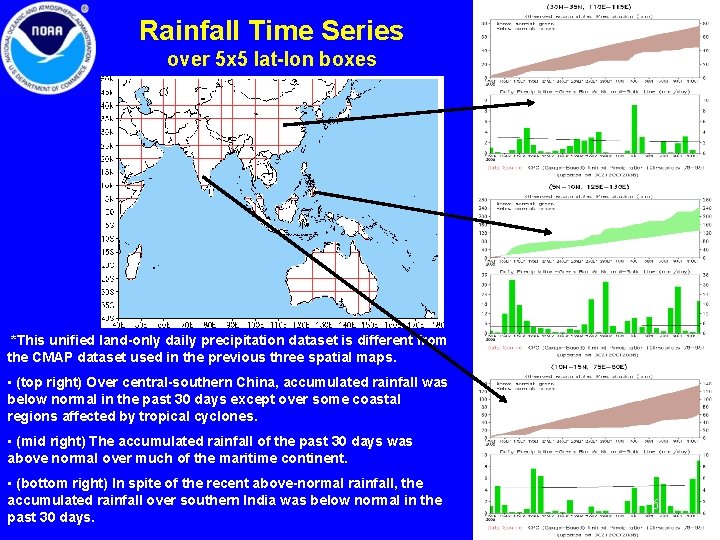
Rainfall Time Series over 5 x 5 lat-lon boxes *This unified land-only daily precipitation dataset is different from the CMAP dataset used in the previous three spatial maps. • (top right) Over central-southern China, accumulated rainfall was below normal in the past 30 days except over some coastal regions affected by tropical cyclones. • (mid right) The accumulated rainfall of the past 30 days was above normal over much of the maritime continent. • (bottom right) In spite of the recent above-normal rainfall, the accumulated rainfall over southern India was below normal in the past 30 days. 6

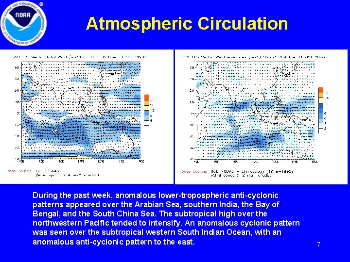
Atmospheric Circulation During the past week, anomalous lower-tropospheric anti-cyclonic patterns appeared over the Arabian Sea, southern India, the Bay of Bengal, and the South China Sea. The subtropical high over the northwestern Pacific tended to intensify. An anomalous cyclonic pattern was seen over the subtropical western South Indian Ocean, with an anomalous anti-cyclonic pattern to the east. 7

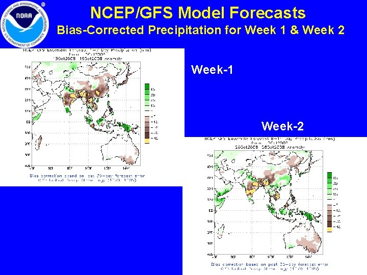
NCEP/GFS Model Forecasts Bias-Corrected Precipitation for Week 1 & Week 2 Week-1 Week-2 8

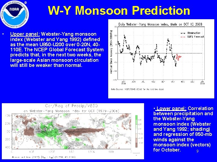
W-Y Monsoon Prediction • Upper panel: Webster-Yang monsoon index (Webster and Yang 1992) defined as the mean U 850 -U 200 over 0 -20 N, 40110 E. The NCEP Global Forecast System predicts that, in the next two weeks, the large-scale Asian monsoon circulation will still be weaker than normal. • Lower panel: Correlation between precipitation and the Webster-Yang monsoon index (Webster and Yang 1992; shading) and regression of 850 -mb winds against the monsoon index (vectors) for October. 9

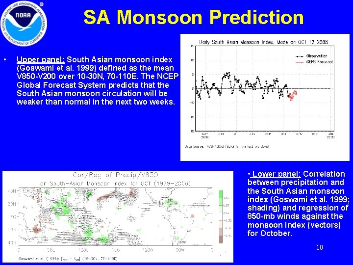
SA Monsoon Prediction • Upper panel: South Asian monsoon index (Goswami et al. 1999) defined as the mean V 850 -V 200 over 10 -30 N, 70 -110 E. The NCEP Global Forecast System predicts that the South Asian monsoon circulation will be weaker than normal in the next two weeks. • Lower panel: Correlation between precipitation and the South Asian monsoon index (Goswami et al. 1999; shading) and regression of 850 -mb winds against the monsoon index (vectors) for October. 10

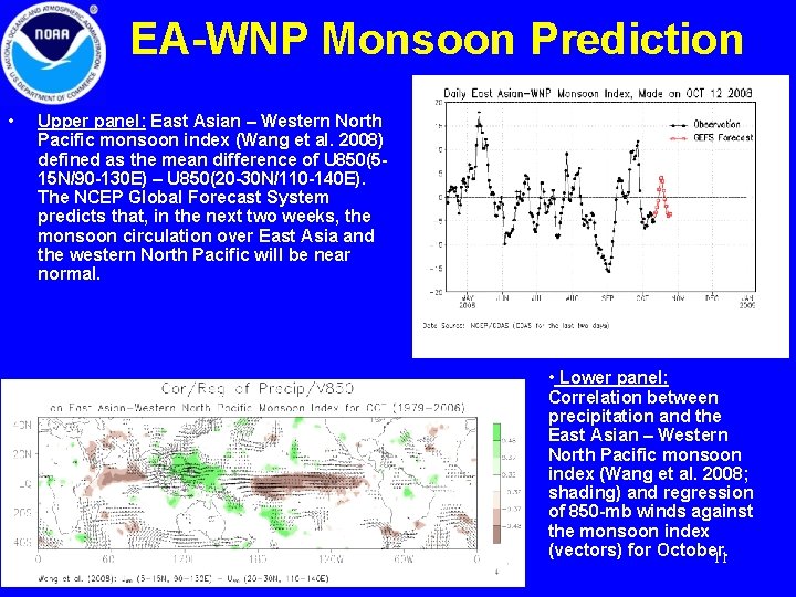
EA-WNP Monsoon Prediction • Upper panel: East Asian – Western North Pacific monsoon index (Wang et al. 2008) defined as the mean difference of U 850(515 N/90 -130 E) – U 850(20 -30 N/110 -140 E). The NCEP Global Forecast System predicts that, in the next two weeks, the monsoon circulation over East Asia and the western North Pacific will be near normal. • Lower panel: Correlation between precipitation and the East Asian – Western North Pacific monsoon index (Wang et al. 2008; shading) and regression of 850 -mb winds against the monsoon index (vectors) for October. 11

Summary • The summer monsoon in 2009 was characterized by near normal precipitation over the lands and above normal precipitation over the tropical oceans. Over India, the accumulated monsoon rainfall was above normal along the Gangetic Plains but below normal over the southern, central, and northwestern India. The eastern and southern Indo -China peninsula is among the regions where most serious deficit of monsoon rainfall occurred. • A prominent precipitation dipole occurred over the tropical Indian Ocean during the past 90 days, with above normal rainfall over the west and below normal precipitation over the east. However, the dipole has undergone a significant change in the past 30 days, in both spatial extent and strength. Eastern Indian ocean has been receiving above normal rains with less rainfall to the west, thus weakening the dipole substantially. • During the past week, precipitation was below normal over much of southern Asia and the adjacent oceans. The NCEP Global Forecast System predicts that the Asian monsoon will continue to be below or near normal in the next two weeks, although rainfall tends to be above normal over the equatorial regions when heavy monsoon rainfall is shifting from the northern hemisphere to the southern hemisphere. 12

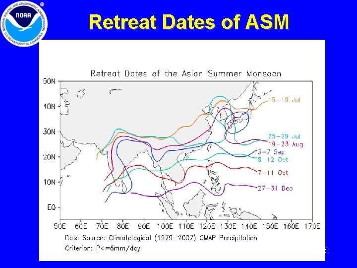
Retreat Dates of ASM 13

Climatology 14