The 5 themes of geography What is geography


 GPS, which stands for Global Positioning System,")

 2. STEPPE 3. MEDITERRANEAN 1. Marine West")


- Slides: 23
The 5 themes of geography
What is geography? ➢ Geography is the study of the physical features and living things on the earth’s surface Or ➢ Anything that can be mapped 2
Two types of geography 1. 2. Physical- study oceans, plant life, landforms Human- study people and how the earth and its people affect each other 3
5 themes of geography M ovement Region H uman- how people change and adjust to their environment. E nvironment interaction Location. Place
Location describes where something is on earth. You can have absolute location, which describes exactly where it is located. To do this you could use degrees of latitude and longitude or an exact address. You can also describe a place using relative location. This is when you describe it in relation to another place. You might say it is near, above, west of, etc. 5
Place describes the physical and human characteristics of a place. Physical characteristics are things like terrain, height above sea level, landforms, and climate. One human characteristic, a place has, is population. 6
region Region describes the similarities you may find in a place. These can include language, culture, and similar historical background. 7
movement Movement describes how people, goods, information, and culture got to a particular place. 8
Human-environment interaction Human-Environment Interaction describes how humans have changed a particular place (such as through canals, highways, etc. ) and how humans adapt to the environment around them (like wearing jackets in cold climates). 9
Hemispheres Northern ➢ Southern ➢ Eastern ➢ Western ➢ 10
Latitude/Longitude ➢ Latitude runs east/west ➢ 0 degrees- Equator ➢ Longitude runs north/south ➢ O degrees- Prime Meridian 11
Parts of a Map ➢ Compass Rose: model of a compass- directions ➢ Scale- relative distance on the map to the real world ➢ Key- what the symbols represent ➢ Grids- letters and numbers that help you find your location 12
Map Projections A map projection is a systematic transformation of the latitudes and longitudes of locations from the surface of a sphere or an ellipsoid into locations on a plane. Maps cannot be created without map projections. All map projections necessarily distort the surface in some fashion. 13
GPS & GIS Global Positioning Systems (GPS) GPS, which stands for Global Positioning System, is a radio navigation system that allows land, sea, and airborne users to determine their exact location, velocity, and time 24 hours a day, in all weather conditions, anywhere in the world. Geographic Information Systems (GIS) A geographic information system (GIS) is a system designed to capture, store, manipulate, analyze, manage, and present all types of geographical data. The key word to this technology is Geography – this means that some portion of the data is spatial. In other words, data that is in some way referenced to locations on the earth. 14
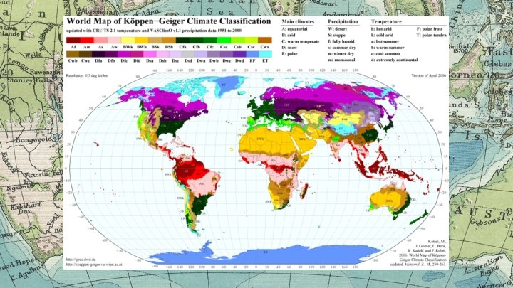
“ Climate s 15
THE 7 CLIMATE ZONES 1. DESERT (Dry) 2. STEPPE 3. MEDITERRANEAN 1. Marine West Coast 4. TROPICAL 1. 2. Tropical Wet/Dry 1. Subtropical Humid 1. 2. Tundra Icecap 5. SAVANNA or CONTINENTAL 6. HIGHLANDS 7. ARCTIC
Effects on CLIMATE Location: Latitude Altitude Topography Wind & Water → Monsoons → Rain-shadows → Water Cycle
1. Location: Latitude Areas of the earth surrounding the equator. → Ranging 30 o North or South → This area is always close to the sun (tropics) → Axis: an imaginary line through the earth; around which it spins and tilts toward or away from the sun
2. Location: Coastal Areas Storms: → Hurricanes: Violent tropical storm systems; → form over the warm Atlantic Ocean Typhoons: same -but form in the Pacific Oceana Weather: → changes in an areas air during short periods of time
3. Location: Physical features Physical Features: → Mountains can block the air from moving inland = Mountain Range = Wind
4. Currents: moving streams of ocean water
5. Monsoons ➢ Seasonal winds. ➢ Winter Monsoons: A wind from the Northeast or North that brings cool drying winds over Asia in the Winter. ➢ Summer Monsoons: A wind from the southwest or south that brings heavy rainfall to southern Asia in the summer.