THE 5 THEMES OF GEOGRAPHY The Tools Geographers


")


- Slides: 53
THE 5 THEMES OF GEOGRAPHY The Tools Geographers Use
Activation • Learning Target? You will be able to identify the 5 Themes of Geography and how each applies to our world. • Unit 1 Test on Friday – Map References – 5 Themes of Geography – The Earth in Space
Geography • An ancient Greek word • Means “earth description” • Geographers are specialists who describe earth’s physical and human features and the interactions of people, places, and environments.
1. Demography - Statistical study of human population; Statistics are information in number form 2. Population Density - average number of people living in an area expressed as persons per square mile: People tend to live in areas that are favorable for settlement 3. Migration - moving from one place to live in another 4. Immigrant – Person who comes to a country and takes up permanent residence 5. Emigrant – Person who leaves their country for residence elsewhere
6. Assimilation -When immigrant groups adopt all of the features of a main culture 7. Acculturation - When an individual or group adopts some of the traits of another culture 8. Diffusion -When an idea or innovation spreads from one person or group to another and is adopted. 9. Culture Region – An area in which people have many shared culture traits. 10. Lingua franca – a language of trade
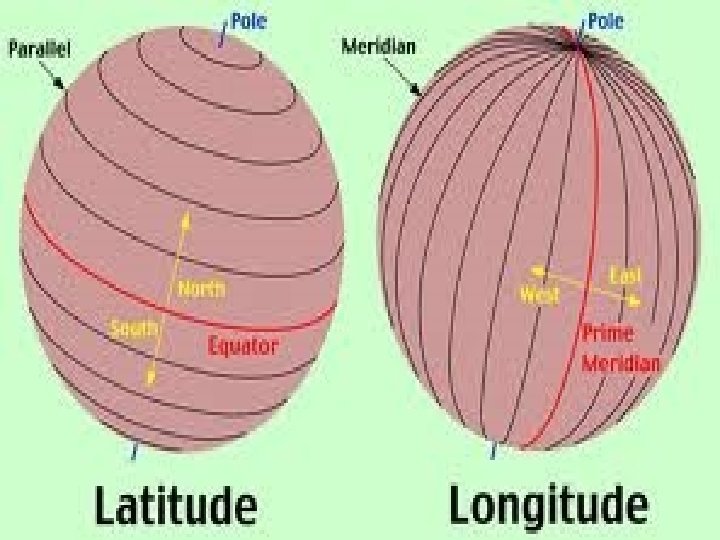
1. Continents: Large landmasses on Earth’s surface. 2. Latitude: Lines on a globe drawn in a east-west direction and measured in degrees. 3. Longitude: Lines on a globe drawn in a north-south direction and measured in degrees. 4. Map projections “Mercator”: Different ways of representing a round Earth on a flat map. 5. Atlas: A collection of maps in one book.
6. Cartography: The study of maps and mapmaking. 7. Great-circle route: Shortest route between any two places on the planet. 8. Compass rose: A map element with arrows pointing in all four primary directions. 9. Topography: Elevation, layout, and shape of the land. 10. Geography: The study of the physical, biological, and cultural features of Earth’s surface. (the study of Earth)
Vocabulary 1. Weather – The condition of the atmosphere at a given time and place 2. Climate – Weather conditions in a region over a long time. 3. Greenhouse effect – The process in which Earth’s atmosphere traps heat energy. 4. Evaporation – Process by which liquid changes to gas. 5. Humidity – The amount of water vapor in
Vocabulary 6. Condensation – The process by which water vapor changes from a gas into liquid droplets. 7. Orographic effect – Cooling effect that occurs when air is forced to rise over a mountain, resulting in a wetter windward side and a drier leeward side. 8. Parallels – Lines of latitude 9. Meridians – lines of longitude 10. Meteorology – the study of weather.
THE FIVE THEMES OF GEOGRAPHY • Location • Place • Human-Environment Interaction • Movement • Regions
LOCATION Where are we? • Absolute Location – The exact spot in which the place is found – A latitude and longitude (global location) or a street address (local location). – Gray, GA is located at 33. 0096° N, 83. 5338° W – The White House is located at 1600 Pennsylvania Ave. • Relative Location locating a place in relation to other places – Described by landmarks, time, direction or distance. From one place to another. You are Her e – Go 1 mile west on main street and turn left for 1 block.
PLACE What is it like there, what kind of place is it? • Human • Physical Characteristics • What are the main languages, customs, and beliefs. • How many people live, work, and visit a place. • Landforms (mountains, rivers, etc. ), climate, vegetation, wildlife, soil, etc.
HUMAN-ENVIRONMENT INTERACTION • How do humans and the environment affect each other? – We depend on it. • People depend on the Tennessee River for water and transportation. – We modify it. • People modify our environment by heating and cooling buildings for comfort. – We adapt to it. • We adapt to the environment by wearing clothing suitable for summer (shorts) and winter (coats), rain and shine.
MOVEMENT • How are people, goods, ideas moved from place to place? – Human Movement • Trucks, Trains, Planes – Information Movement • Phones, computer (email), mail – Idea Movement • How do fads move from place to place? TV, Radio, Magazines
REGIONS • How are Regions similar to and different from other places? – Formal Regions • Regions defined by governmental or administrative boundaries (States, Countries, Cities) • Regions defined by similar characteristics (Corn Belt, Rocky Mountain region, Chinatown). – Functional Regions • Regions defined by a function (newspaper service area, cell phone coverage area). – Perceptual Regions • Regions defined by peoples perception (middle east, the south, etc. )
Remembering the 5 themes • If you can’t remembering what they are just ask MR. HELP!!! • M – Movement • R – Regions • HE – Human Environment interaction • L – Location • P - Place
Vocab –August 20 • • rotation Revolution Solstice Equinox Meteorology Weather Climate • • • Greenhouse Effect Evaporation Condensation Evaporation Orographic effect Humidity
The Solar System Press
press
Almost all of the earth’s energy comes from the sun The Earth • 3 rd planet from Sun • 5 th largest of the nine planet • The circumference of Earth at the equator is about 24, 902 miles , but from pole-to-pole — the meridional circumference — Earth is only 24, 860 miles around.
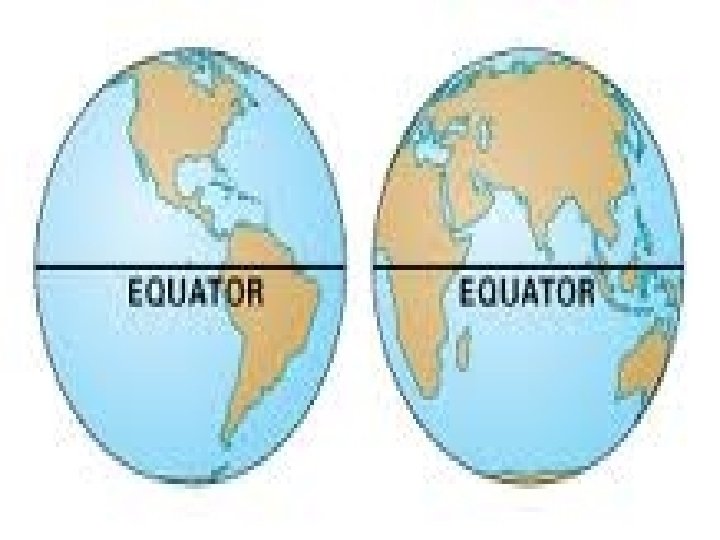
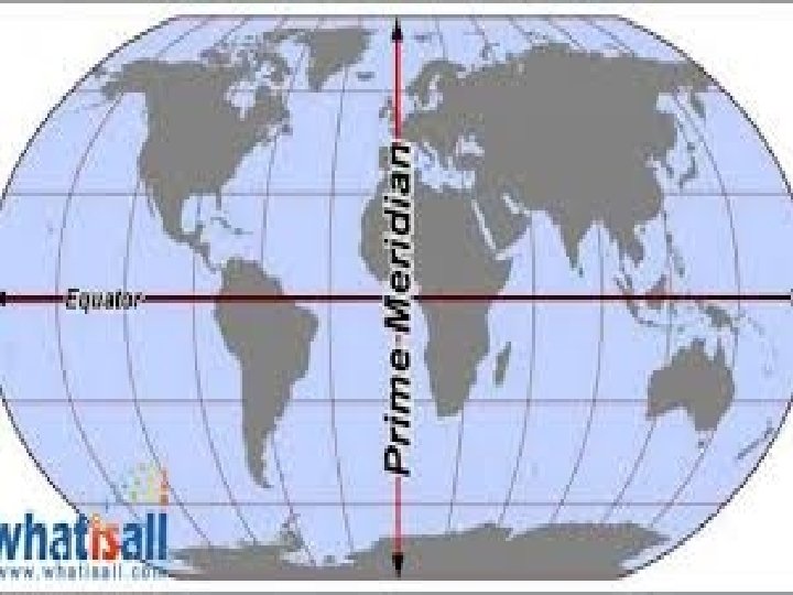
World Map • • • Equator – Yellow Prime Meridian – Red Greenwich, England – Green Latitudes – Longitudes –
Rotation vs. Revolution Rotation 1 rotation or spin = 24 hours Sun rises in east and sets in the west Can you think of other things that spin? Revolution One orbit around the sun Takes 1 year (365 ¼ days) This is why we have leap year every 4 years (Feb. 29)
Tilt Earth’s axis is tilted in relation to the Sun (at 23. 5 degrees) As earth revolves around the Sun, the North Pole sometimes tilts toward the Sun and sometimes away from the sun. Gets more sunlight at time of year it is tilted toward the sun. (seasons)
Does Latitude Affect Climate? • Latitude exerts a large amount of control over any given area’s climate. --latitude is probably the single most important determining factor in climate. --other variables * weather patterns * elevation
Solstice Time of the year when poles point at the greatest angle toward or away from the sun. For us (the Northern Hemisphere) December 21 – first day of winter (away from sun) June 21 – first day of summer (toward the sun) Note: December 21—shortest day of the year June 21—longest day of the year Southern Hemisphere is opposite December 21 – first day of summer (toward the sun) June 21 – first day of winter (away from sun)
Equinox Press Means equal night Sun’s direct rays strike the equator, and both poles are at 90 degrees from the Sun. Both hemispheres get an equal amount of sunlight. (12 hours each) March 21 – beginning of Spring in NH, beginning of fall in the SH. September 22 – beginning of Fall in NH, beginning of Spring in the SH.
Compass Rose Principle Directions: North, East, South & West Intermediate Directions: NE, SW & NW
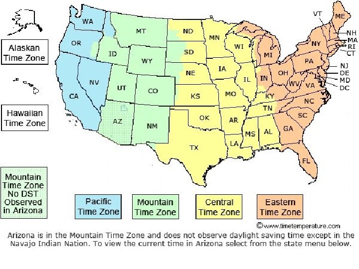
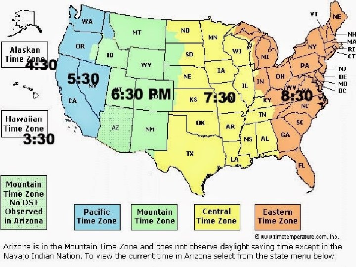
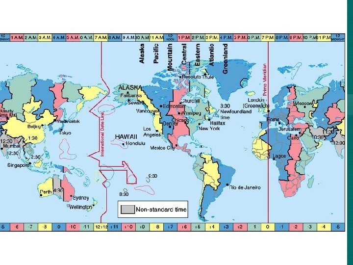
Time Zones • • 1878 Sir Sanford Fleming 24 time zones worldwide Each spaced 15 degrees of longitude apart • November 1883—railroad companies across U. S. and Canada began to use standard time zones. Why? • 1918—Congress established official time
Great-circle route: Shortest route between any two places on the planet.
Various Types of Maps/Map Projections
Cylindrical/Mercator A cylindrical projection is a type of map in which a cylinder is wrapped around a sphere (the globe), and the details of the globe are projected onto the cylindrical surface. Then, the cylinder is unwrapped into a flat surface, yielding a rectangularshaped map. Cylindrical maps have a lot of distortion in the polar regions.
Chapter 3 Weather and Climate The Sun plays the major role in Earth’s weather and climate patterns.
Does Latitude Affect Climate? • Latitude exerts a large amount of control over any given area’s climate. --latitude is probably the single most important determining factor in climate. --other variables * weather patterns * elevation
The Sun’s Effect on Earth The Sun’s energy reaches Earth. Half of the energy is reflected back into space or absorbed by the atmosphere The other half is absorbed by the Earth’s surface and converted into heat energy. The atmosphere traps this heat in a process called the greenhouse effect. The greenhouse effect helps keep the planet warm.
Oceans and Currents Oceans affect climate. Ocean currents move heat back and forth between the tropics and the polar regions.
3. 2 Weather Factors
Precipitation—rain that comes in all different forms, depending on the temperature of the atmosphere.
Orographi c
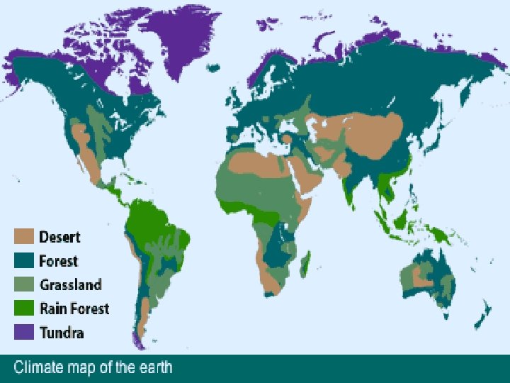
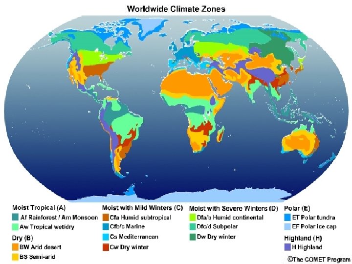
Chapter 3. 3 Climate and Vegetation Patterns
Tropical Humid Climate • • • Close to the equator Warm temperatures Plentiful rainfall Vegetation: Rainforest
Tropical Wet and Dry Climate • Just north and south of the tropical humid climate • Seasonal change in the way the Sun’s rays strike areas just north and south of equator Savannas—areas of tropical grasslands, scattered trees, and shrubs
Dry Climates Arid • “dry” • Centered 30 degrees north and south of equator • Caused by the subtropical high pressure zone Semiarid • Transition zone between arid climate and the more humid climates • Receives more moisture than the deserts
Middle-Latitude Climates • Mediterranean • Humid Subtropical • Marine West Coast • Humid
High-Latitude and Highland Climates • • • Subarctic Tundra Ice Cap • Highland