TEMPERATURE T is measured as the average kinetic
 is measured as the average kinetic energy of the atoms and")


")


 can pass thru it. Thus,")


 to heat up water than it does the")
 and Wichita, USA (continental location) also")


")


- Slides: 30
TEMPERATURE (T ) is measured as the average kinetic energy of the atoms and molecules of an object or substance. (Heat is the total kinetic energy. ) When the atoms of a substance or object are moving faster this means greater kinetic energy, which means the substance will have a higher T.
Even a solid object will have kinetic energy since its atoms/molecules exhibit molecular vibration or rotation. Thus, it also has a temperature (T°)
The three commonly used temperature scales. They are all based on the temperature at which water changes state (solid to liquid to gas). You will need to know how to convert from one to anther.
Some common T°s and some extremes. A contested “official” highest T° of 134. 1° F (56. 7° C) was recorded in 1913 by the U. S. National Park Service in Death Valley NP (CA, USA). The highest verified record is 129. 9° F (54. 4° C) in death Valley from 2020. The record on the chart to the right was invalidated in 2012.
An instrument shelter for the collection of weather data to include T°, barometric (air) pressure, wind speed and direction, etc. Official air temperatures are taken in the shade, three feet above a grassy surface with at lest 50 yards of open space around the sensor. So, if it feels hotter standing in the sun compared to the officially recorded T°, it is hotter in the direct sunlight, as much as 10° -15° hotter.
Instruments for measuring air temperature.
Isotherms indicating average January temperatures. An isotherm refers to a line on a map or chart that connects points of equal temperature.
Receipt of Solar Radiation refers to the amount of solar radiation a location receives. The locations latitude determines this. On an annual basis, lower latitudes (closer to 0 , the Equator) receive more solar radiation than higher latitudes. This is the primary control of temperatures at the Earth’s surface. Locations near the Equator receive similar amounts of solar radiation each month, thus their T does not vary much throughout the year (Salvador, Brazil). While locations further away from the Equator receive a more varied amount of short-wave energy throughout the year, thus exhibit greater T variation (Barrow, Alaska, USA).
Land water surfaces heat at different rates due to several factors. Because of this, land surfaces cool and warm more quickly than water surfaces, and to lower and higher T s.
Water is more transparent than land so SW (sunlight) can pass thru it. Thus, the solar energy striking the water penetrates the water and energy is being absorbed throughout this greater volume of water, trying to ‘heat-up’ all this water.
Land is opaque, thus solar energy is only absorbed at the surface and its energy is concentrated and absorbed at the surface. It is “trying to heat-up” a smaller volume of material (soil, rock, etc. ) compared to a water area.
Evaporation from water is greater than land, thus energy is used to evaporate the water and not just raise the T. Water also exhibits turbulence and movement causing water that has been heated to be replaced by cooler water that must be heated. This movement will be both horizontal and vertical.
It takes more solar energy (sunlight) to heat up water than it does the same amount of land. Thus, water has a moderating influence on T° such that inland locations show greater T° variation between winter and summer. This is the idea of continentality. The cities of Vancouver, Canada (maritime location) and Winnipeg, Canada (continental location) illustrate this idea.
The cities of San Francisco, USA (maritime location) and Wichita, USA (continental location) also illustrate this idea.
Geographic Setting and Position refers to the T° differences brought about by a location being on one side of a continent versus the other. Compare the Annual T° Range at the same latitude between the West Coast and East Coast of the U. S. The range is smaller on the West Coast (look at the 40° N line).
Wind direction and whether the wind is coming off a land surface or a large water surface factors into the idea of Geographic Setting. Red arrows indicate the primary wind direction across North America, west to east, making the West Coast the Windward side and the East Coast the Leeward side. Windward Leeward
Warm water currents move warm water from tropical areas toward polar regions, and cold-water currents move cold water from polar regions toward the tropics. Warm currents will help keep the T higher than it would be without the current, especially in winter. Cold currents will help keep the T lower than it would be without the current, especially in summer.
The Gulf Stream moves warm water along the North American east coast and on to Europe. Red and orange colors represent warmer T°s, while blues and purples represent colder T°s.
Average annual sea-surface T°s shown on these diagrams indicate that the T°s off the coast of Ireland are warmer throughout the year compared to locations in Canada at the same latitude. This is the result of the Gulf Stream moving warmer water north and across the Atlantic Ocean.
Elevation influences T simply because within the troposphere as elevation increases, T normally decreases.
Locations at higher elevations usually have lower average annual temperatures compared to lower locations.
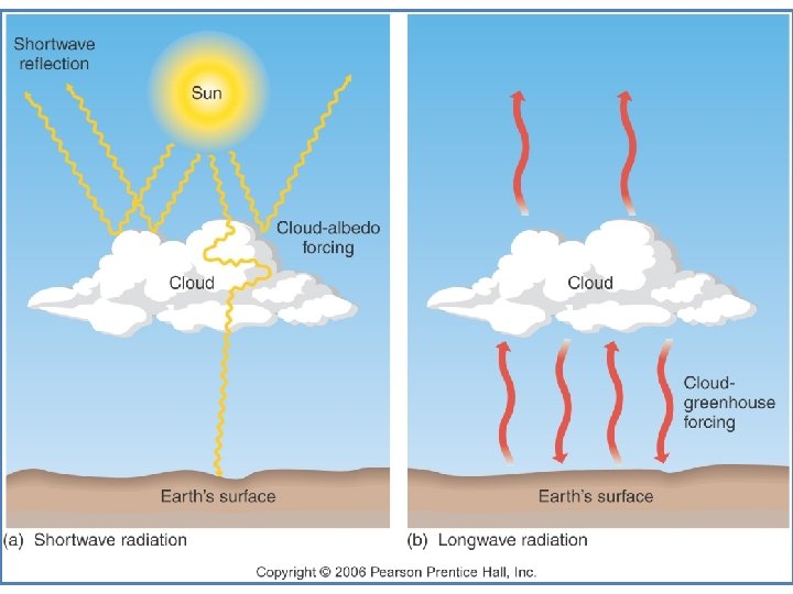
Cloud Cover and Albedo affect surface temperatures by controlling the levels of solar and terrestrial radiation at the Earth’s surface. Clouds trap-in terrestrial radiation keeping the surface warmer (Greenhouse Effect), but they will also reflect solar radiation coming in causing the surface to be cooler.
Clouds, even jet aircraft contrails, can influence surface T°s by blocking incoming sunlight and/or blocking outgoing terrestrial radiation.
Temperature varies through the day with the changing energy dynamics and changing cloud conditions. Usually, a cloudy day is cooler than a clear day and a cloudy night is usually warmer than a clear night. Variation in Tº on a clear day (top) and a cloudy day (bottom).
The Southern Hemisphere has 81% water and 19% land, thus T variations and range are smaller across the Southern Hemisphere.
The Northern Hemisphere has 61% water and 39% land, thus greater T variations, especially over the land surfaces, and greater wintertime variations with latitude than summer.
Coldest annual T s are usually over land at high latitudes in winter (Siberia) and the Warmest annual T s are usually in the tropical deserts in summer (Sahara).
Wind Chill Temperature Index refers to the effect of wind and temperature on a person’s body which can lead to increased heat loss from the body and a lowering of body T°. The wind moves heat generated by the body away from the body, thus the body must work harder to generate more heat.
Heat Index refers to the effect of humidity and temperature on a person’s body which can lead to an increase of body T°. High humidity (the amount of water vapor in the air) decreases the body’s ability to cool down by sweating, thus increasing the body temperature.