TAT 901 Hydrology STREAMFLOW RAINFALL RUNOFF Nur Liza


 Depth (m) Velocity at 0. 6 D (m/s)")


 Moderate 20 -30 (mm) Heavy")


 �")


 become direct runoff")

")
 Residential (30%) 40 72 2880")
2 P + 0. 8 S = [5")

 Calculate the increase in effective rainfall due to urbanization for a")

- Slides: 43
TAT 901 Hydrology STREAMFLOW & RAINFALL RUNOFF Nur Liza Binti Rahim School of Environmental Engineering
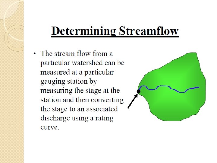
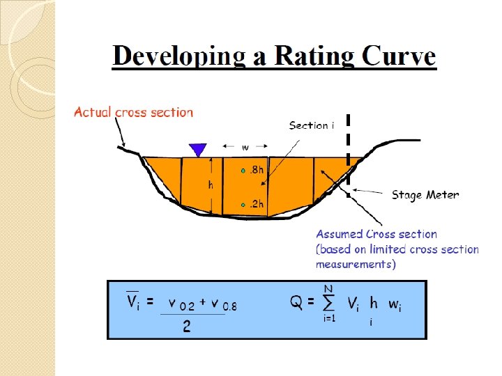
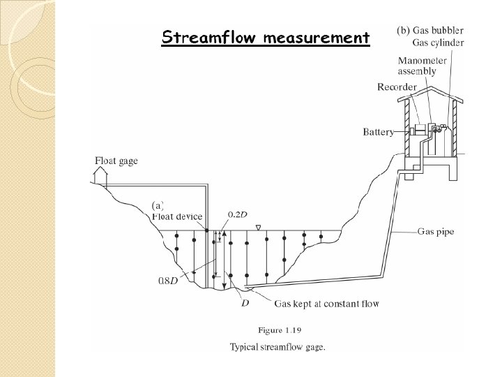
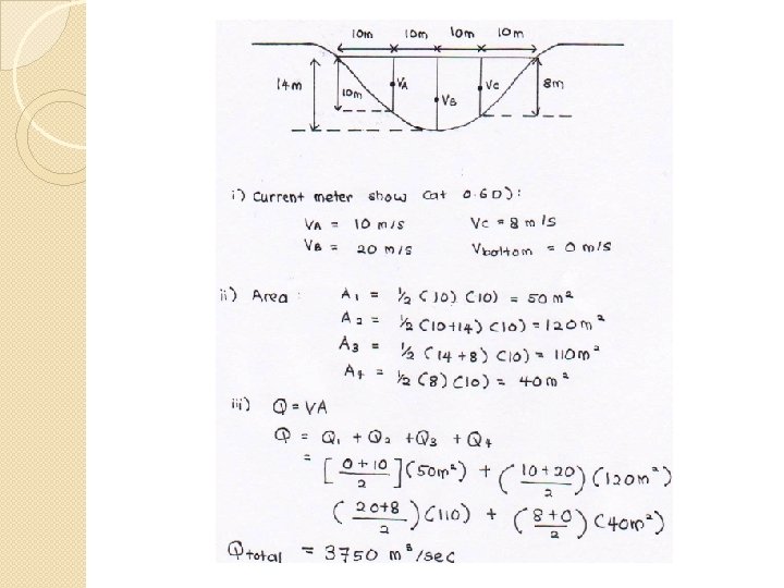
Procedure: Measure channel width by using a tape meter. Divide the cross section of the river to a several vertical lines, measure the depth of vertical lines Repeat to all vertical lines Put current meter at the vertical lines – 0. 6 Depth (more accurate 0. 2 D & 0. 8 D, calculate average) Calculate mean velocity between 2 vertical lines. Calculate area – using area of triangular @ trapezium Mean velocity x area. Calculate Q total
TRY THIS… Vertical Line Width (m) Depth (m) Velocity at 0. 6 D (m/s) 1 1 0. 4 0. 8 2 1 0. 7 1. 1 3 1 0. 9 1. 2 4 1 1. 4 5 1 0. 9 1. 1 6 1 0. 2 0. 3
Rainfall - Runoff
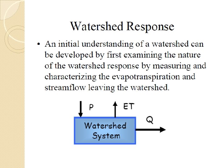
Rainfall - Runoff �Hydrologist are concerned with the amount of surface runoff generated in a watershed for a given rainfall pattern, and attempts have been made to analyze historical rainfall, infiltration, evaporation, and streamflow data to develop predictive relationships
Rainfall �Rain is liquid precipitation, as opposed to other kinds of precipitation such as snow, hail and sleet.
Rainfall �The standard way of measuring rainfall or snowfall is the standard rain gauge Rajah 3. 1: Stesen hujan dan stesen paras air
Procedure for rainfall data collection Tipping bucket Hydro logger and Scram Card Scram card read by Hydro Reader Computer with TIDEDA software
Categorization of Rainfall Intensity � Light 1 -10 (mm) Moderate 20 -30 (mm) Heavy 30 -60 (mm) Very Heavy >60 (mm)
Runoff � When rain or snow falls onto the earth, it just doesn't sit there -- it starts moving according to the laws of gravity. � A portion of the precipitation seeps into the ground to replenish Earth's groundwater. Most of it flows downhill as runoff. � Runoff is extremely important in that not only does it keep rivers and lakes full of water, but it also changes the landscape by the action of erosion.
Runoff � Water that does not infiltrate the soil runs off across the surface of the watershed. � Runoff begins as a sheet of water and then turns into small trickles and then streams. � Runoff may contribute water directly to lakes or it may flow first to steams (streamflow) and then to lakes or the ocean.
Runoff � Runoff can erode the land surface, leading to pollution of lakes and rivers. If precipitation is intense and/or the soil is saturated, flooding can occur. � Watershed managers try to reduce erosion and flooding by using good land use practices and by building control structures.
Runoff � Runoff is generated by rainstorms and its occurrence and quantity are dependent on the characteristics of the rainfall event, i. e. intensity, duration and distribution. � There are, in addition, other important factors which influence the runoff generating process
Meteorological factors affecting runoff: � Type of precipitation (rain, snow, sleet, etc. ) � Rainfall intensity � Rainfall amount � Rainfall duration � Distribution of rainfall over the watersheds � Direction of storm movement � Antecedent precipitation and resulting soil moisture � Other meteorological and climatic conditions that affect evapotranspiration, such as temperature, wind, relative humidity, and season
Physical characteristics affecting runoff q Land use q Vegetation q Soil type q Drainage area q Basin shape q Slope q Direction of orientation q Ponds, lakes, reservoirs, sinks, etc. in the basin, which prevent or alter runoff from continuing downstream q Elevation q Topography q Drainage network patterns
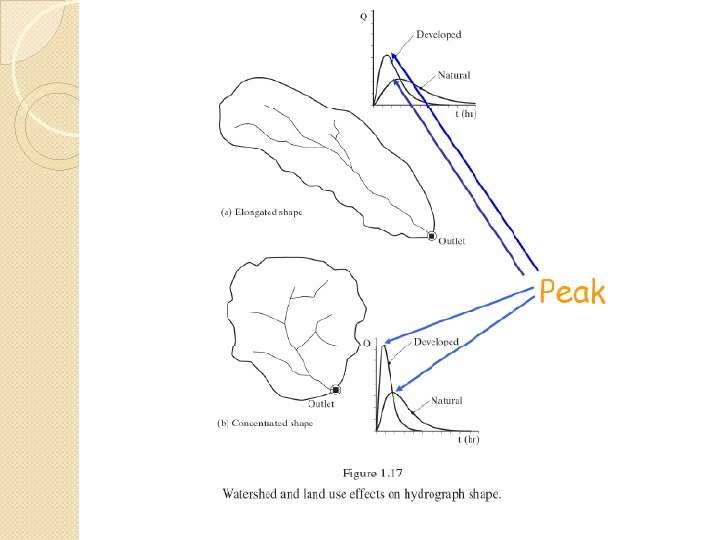
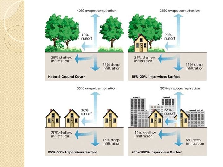
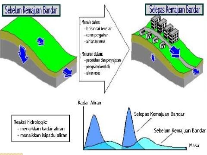
Human activities can affect runoff � As more and more people inhabit the Earth, and as more development and urbanization occur, more of the natural landscape is replaced by impervious surfaces, such as roads, houses, parking lots, and buildings that reduce infiltration of water into the ground accelerate runoff to ditches and streams. � In addition to increasing imperviousness, removal of vegetation and soil, grading the land surface, and constructing drainage networks increase runoff volumes and shorten runoff time into streams from rainfall and snowmelt. As a result, the peak discharge, volume, and frequency of floods increase in nearby streams.
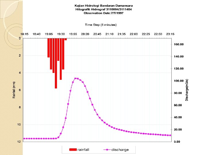
�Runoff that is not extracted from the land surface by evaporation and transpiration is delivered to streams, lakes and oceans. Changes in stream flow over time can be illustrated using a hydrograph or water picture
Hydrograph
� The flat portion of the hydrograph is called baseflow and represents inputs to the stream from groundwater. � The portion of the hydrograph above baseflow is called direct runoff and indicates the presence of a rain or snow melt event.
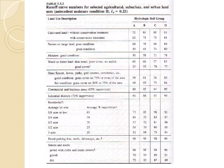
SCS Method For Abstraction: To calculate amount of surface runoff �The soil conservation service (SCS) method can be used to compute abstraction from storm rainfall. We know : P = Pe + Ia + Fa P = total precipitation Pe = excess rainfall Ia = Initial abstraction Fa = Continuing Abstraction
�From study of small experimental watershed, an empirical relation was developed. These equations show relationship between excess r/f and total r/f. REMEMBER THIS !! Pe = (P - 0. 2 S)2 P + 0. 8 S S = 1000 – 10 CN
�From the study, a plot of data of P vs Pe was made;
Curve number depend on Land Use Soil Type The higher the curve number, the smaller the abstraction value is. Example using CN curve of 100, 10’’ rainfall become 10’’ excess rainfall. So all rain become surface runoff.
There are 4 soil types: Type A = deep sand, deep loess, aggregated silts. Infiltration rate: 0. 3 – 0. 45 Type B = Shallow loess, sandy loam. Infiltration rate: 0. 15 – 0. 30 Type C = Clay loams, shallow sandy loam. Infiltration rate: 0. 05 – 0. 15 Type D = Heavy plastic clay. Infiltration rate: 0. 0 – 0. 05 Note that from CN table, sand (type A) allow higher infiltration rate, so CN value for sand is smaller
�In normal study, we need to know how much r/f (P) become direct runoff (Pe) – Given rainfall value, we are asked to calculate runoff To do it, find out the soil type of watershed and it’s landuse, get the curve number. Then solve by using the graph or using the equations. If surface is totally impervious (e. g road), the CN value is 100, values of P = Pe meaning all rain become direct runoff. If the surface is a big tank (like lake) CN value is 0 and no rain become surface runoff.
EXAMPLE 1 �Compute the surface runoff from 5 inches of rainfall on a 1000 acres watershed. The hydrologic soil group is 100% group B. The landuse is: � 40% residential area that is 30% impervious � 12% residential area that is 65 % impervious � 18% paved road with curbs � 16% open land with fair grass cover � 14% parking lots, plaza etc.
Solution… �Fill in this table first. . LANDUSE SOIL TYPE B % Residential (30%) 40 Residential (65%) 12 Roads 18 Open Land, fair condition 16 Parking lot 14 CN value %(CN)
LANDUSE SOIL TYPE B v % CN value %(CN) Residential (30%) 40 72 2880 Residential (65%) 12 85 1020 Roads 18 98 1764 Open Land, fair condition 16 69 1104 Parking lot 14 98 1372 Total = 100 Weighted CN = 8140/100 = 81. 4 S = 1000/ CN - 10 = 1000/81. 4 - 10 = 2. 285 in Total = 8140
Pe = (P - 0. 2 S)2 P + 0. 8 S = [5 – 0. 2 (2. 285)]2 5 + 0. 8 (2. 285) = 3. 0227 in Total runoff = area x excess rainfall = (1000 acre) ( 3. 02 inch) = 310516. 77 m 3 1 ft = 12 inch I m = 3. 28 ft 1 acre = 4. 047 x 103 m 2
In the last 20 years, hydrologists have paid considerable attention to effects of urbanization on the flood hydrograph. The effects include increase total runoff volumes and increase in peak flow rates: a) Volume in water available for runoff increases because of the increased impervious area provided by parking lots, streets, etc b) Increase in hydraulic efficiency, e. g better drainage system, velocity of flow increases and peak flow increases.
TRY THIS =) Calculate the increase in effective rainfall due to urbanization for a 5 inches r/f on a 1000 acre watershed. The soil type is B. The landuse is open land with fair condition before urbanization, after urbanization it is 30% industrial district and 70% residential (1/8 acres 65% impervious). STEP: 1) Calculate Pe before urbanization 2) Calculate Pe after urbanization 3) Pe after – Pe before
Solution. . • S = 4. 49 in Befor • Pe = 1. 9584 e in After Increase in effective r/f • S = 1. 6414 in • Pe = 3. 4571 in • 3. 4571 – 1. 9584 = 1. 5 in