TAMDAR GLOBAL WEATHER SOLUTIONS AIRDAT HISTORY The TAMDAR

TAMDAR: GLOBAL WEATHER SOLUTIONS

AIRDAT HISTORY • The TAMDAR goal: • • • Deliver all metrics of weather balloons from commercial aircraft Assure space-time data coverage for airports sector GPS stamp all data Add additional electronic pilot reports (icing, turbulence, temp) Initial focus on regional aircraft to provide better geographic coverage • Air. Dat was founded in 2003 • First STC and operational weather data in 2004 • Assets purchased by Panasonic Avionics Corporation in 2013 © 2013 . Proprietary and Confidential

TAMDAR Tropospheric Airborne Meteorological Data Reporting • Delivers a unique real-time high resolution data stream for improved atmospheric analysis and weather forecasting • Patented and operational on commercial aircraft since 2004 • Goal: Deployment of TAMDAR and development of superior atmospheric information tools driven by the TAMDAR dataset • Panasonic Avionics Corporation is expanding the TAMDAR network worldwide © 2013 . Proprietary and Confidential
 • Two-way")
THE TAMDAR SYSTEM • Multi-function atmospheric sensor installed on aircraft (and UAS) • Two-way real time Iridium satellite link • Dedicated data center for quality monitoring, archiving, and distribution systems • Development and integration of customized forecasts and weather applications • Enhanced forecast models • High-speed computing resources © 2013 . Proprietary and Confidential

TAMDAR GLOBAL COMMUNICATION • Autonomous communication to and from any TAMDAR-equipped aircraft, at any altitude or location worldwide (even on the ground) • Low message latency (near real-time) • Channel also available for: w Other data transmission w Text messaging to/from aircraft w Backup voice channel w Aircraft tracking © 2013 . Proprietary and Confidential Iridium satellite constellation (global, secure, high availability)

KU BAND COVERAGE

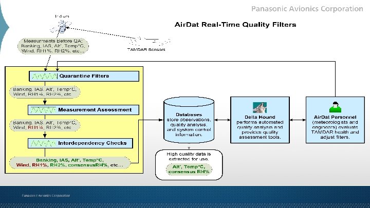
TAMDAR DATA QA and FORECAST MODELS • Multi-Layer automated quality assurance through proprietary algorithms • Data distributed, archived, and ingested into proprietary weather models • Weather Research Forecasting (WRF) model with Real Time Four Dimensional Data Assimilation (RTFDDA) © 2013 . Proprietary and Confidential Panasonic’s powerful computing clusters run proprietary WRF/RTFDDA

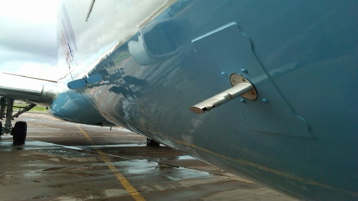
THE TAMDAR SENSOR Measures and reports: • Ice presence • Static pressure and pressure altitude • Air temperature (Mach corrected) • Relative humidity • Indicated and true airspeed • Winds aloft • Turbulence (EDR, median and peak) • GPS lat/long/alt/time

TAMDAR-U Optimized for Unmanned Aerial Systems • Reduced size, weight, and power • Worldwide deployment options for improved local forecasts • Innovative, light-weight materials

WEATHER DATA TRANSMISSION • System is automatic, begins sampling during take-off • Sampling rate flexible, changeable in real-time • Uses an automatic pressure based sampling program: • • High resolution sampling on ascent/descent (~300’ intervals) Time based sampling in cruise (5 to 7 minute intervals) Triggered reports in dynamic conditions Custom reporting available • 40, 000+ observations and ~2500 soundings daily • Real-time data access through the Air. Map portal

BENEFITS TO PARTNER AIRLINES • Global SATCOM voice & data via Iridium • Automated Out-Off-On-In times and other aircraft data • Real-time global aircraft position reports • Airborne datalinked weather • Weather data downlink • Auto-PIREPs • Data base of all flight histories • Asset tracking

TAMDAR AIRBORNE SYSTEM – 3 UNITS • TAMDAR Probe • SATCOM Transceiver and Aircraft Interface Unit • Antenna

ON BOARD TAMDAR SYSTEM • Processing Unit: 3 MCU, ARINC 600 installation • Communications, data processing • • • RS-232, RS-422, and discrete inputs/outputs ARINC 429 and 717 inputs/outputs Single SATCOM transceiver DO-178 B level E software Aircraft audio Ethernet

ON BOARD TAMDAR SYSTEM • Weather • • TAMDAR processing GPS position Air. Map data ARINC 620 weather data • Antenna • Active GPS (TAMDAR) • 2 Iridium SATCOM

ERJ-190 Integration Configuration


TAMDAR® observation 18

TAMDAR winds

TAMDAR coverage in Mexico

TAMDAR in Europe

Background Note: Over 100 daily soundings from LGA, JFK, EWR 23

The 2 images show TAMDAR data from flights into/out of BUF +/- ~3 h from 10 pm. Crash site The solid triangles indicate icing, and the hollow triangles indicate icing with heaters activated. BUF Crash site BUF The TAMDAR heater remains activated throughout the descent, so the ice accretion rate is > 0. 02” / min. TAMDAR observations around the time of the Colgan crash

TAMDAR observations around the time of the Colgan crash The first sounding, valid 9 pm, shows a substantial layer of saturated air below 6000' between -9 and 2 C -- the temperature window that most supports the existence of supercooled water. The second sounding, valid 11: 20 pm, shows the sub-0 C saturated layer has dropped to 3000' and below Both soundings suggest favorable conditions for supercooled water to freeze upon airframe contact.

Next. Gen Aviation Weather Impact Data Air. Dat Augmented WRF Model Icing Impact Forecast WRF forecast model projections improved with TAMDAR icing observations. – 3 -D weather impact poly-regions conveyed as Airspace Volumes of Interest.

End-to-End Impact/Alert Data STARS Icing Alerts Next. Gen Net-enabled Weather Flow Icing Impact Alert STARS display of Air. Dat derived Weather Volumes. Note two aircraft within altitude threshold predicted to enter volumes display a “WX” alert in datablock. 91 st American Meteorological Society Annual Meeting Copyright © 2011 Raytheon Company. All rights reserved. 27

NEXTGEN: NNEW & NWP Raytheon, Air. Dat, and Metron Aviation have teamed to support two major FAA Next. Gen weather programs with superior weather information, integrated displays, and decision support solutions: • Next. Gen Network Enabled Weather (NNEW) • Next. Gen Weather Processor (NWP) Weather State Information Integration ATM Impact Analysis Tools High-Resolution Modeling Information Displays ATM Decision Support Tools © 2013 . Proprietary and Confidential

WHY TAMDAR? Validated by NOAA via 4 -year FAA-funded TAMDAR impact study* • Temperature 3 -hour forecast errors are reduced by up to 28%. • Wind forecast 3 -hour errors are reduced by up to 10%. • Relative humidity 3 -hour forecast errors are reduced by up to 50%. *William Moninger, 13 th Conference on Integrated Observing and Assimilation Systems for Atmosphere, Oceans, and Land Surface American Meteorological Society, January 2009

TAMDAR IMPROVES ALL MODELS Improvements in forecast skill: TAMDAR over without-TAMDAR, (RAOBs used as "truth“) NOAA's most optimized model for aircraft data is RUC Air. Dat 3 D-Var WRF is essentially the same code as NCAR 3 D-Var WRF Air. Dat RT-FDDA and 4 D-Var WRF are best suited to utilize asynoptic observations 30

TAMDAR CASE STUDIES © 2013 . Proprietary and Confidential
 Five-hour")
TAMDAR IMPROVES WINDS FORECASTS Surface wind forecast comparison, Toronto Airbus incident (August 2005) Five-hour forecast - NO TAMDAR Five hour forecast - WITH TAMDAR a b PEARSON INTL AIRPORT Hazardous winds 1 -h 10 -m winds (kts, averaged from fcst hour 4 to 5) showing NW flow. 1 -h 10 -m winds (kts, averaged from fcst hour 4 to 5) showing UPDRAFT (a) and DOWNDRAFT (b) regions. 32

“Superstorm” Sandy Air. Dat Old Tropical Air. Dat New Tropical NOAA GFSE Observed Track
 34")
84 h forecasted track for Ike - Air. Dat, NCEP, and NHC (inset) 34 34

Successive Air. Dat WRF Runs 35 35 35
 Synoptic Overview (Air. Dat) Shortwave trough 2 36 Shortwave trough 1")
Synoptic Overview (NCEP) Synoptic Overview (Air. Dat) Shortwave trough 2 36 Shortwave trough 1 Shortwave trough 2 L Ridge L L Ridge

North Carolina Tornado Outbreak 16 April 2011
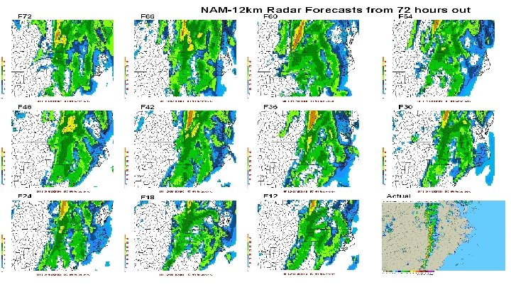
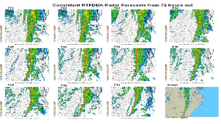
 NWS (NAM) 18 z Actual Radar")
12 Hours Ahead Air. Dat (RTFDDA) NWS (NAM) 18 z Actual Radar
 NWS (NAM) 18 z Actual Radar")
12 Hours Ahead Air. Dat (RTFDDA) NWS (NAM) 18 z Actual Radar
 NWS (NAM) 18 z Actual Radar")
12 Hours Ahead Air. Dat (RTFDDA) NWS (NAM) 18 z Actual Radar
 NWS (NAM) 18 z Actual Radar")
12 Hours Ahead Air. Dat (RTFDDA) NWS (NAM) 18 z Actual Radar

CONTACT INFORMATION Jeff Rex Panasonic Weather Solutions 2535 South Lewis Way, Suite 203 Lakewood, CO, US 80227 +1 (303) 501 -4359 Jeff. Rex@panasonic. aero © 2013 . Proprietary and Confidential
- Slides: 44