SVAP 2 Serbia Edition Stream Visual Assessment Protocol

SVAP 2, Serbia Edition Stream Visual Assessment Protocol Version 2 Joseph Flotemersch USEPA, Office of Research & Development Clayton Cox AAAS Fellow c/o USEPA, Office of Research & Development Kelsey Aho ORISE Fellow c/o USEPA, Office of Research & Development Office of Research and Development Full Name of Lab, Center, Office, Division or Staff goes here. <Go to View, Master, Title Master to change>

SVAP History • A qualitative visual assessment tool • Evaluates physical, chemical, and biological features affecting wadeable stream conditions • Developed in 1999; Revised in 2009 (SVAP 2) ü US Department of Agriculture’s Natural Resources Conservation Service (NRCS) ü University of Georgia (1999).

What is a healthy stream? Factors that influence stream quality or condition Modified from Karr 1986

SVAP 2 for Serbia Incorporating Metrics of the Water Framework Directive

SVAP 2 Basics • Describes overall condition for a specified section of stream • Compare scores at that stream to a “typical” reach of streams in the area üReference reaches of streams in Serbia

SVAP 2 use in Serbia! • Scores ecological and physical variables that are least sensitive to regional differences • Note: Regional variation in stream conditions exist and should be acknowledged • Scoring elements should be modified as needed to reflect regional differences in physical landscape features and weather patterns

SVAP 2 Training Module April 2009

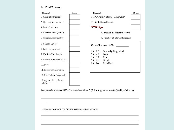
SVAP 2 Scoring • 16 possible stream elements to score –Score only those elements that are relevant to the site • Score range – 10 = best conditions, 0 = worst conditions • Modify protocol’s elements to reflect local conditions, where applicable

Preliminary Data Collection • Collect basic information: ü ownerships, land uses ü ecoregion ü watershed features such as water diversions ü “natural” flow regime ü aquatic species of concern ü identification of suitable reference stream, for comparison and scoring accuracy

What is the best condition we can expect for a given stream?

Assessment Reach • Score one stream reach per assessment, unless additional reaches are warranted due to multiple land uses or ownerships. • Choose a reach based on channel type. • Stream reach = at least 12 X the width of the stream channel at bankfull stage.

I d e n t i f y i n

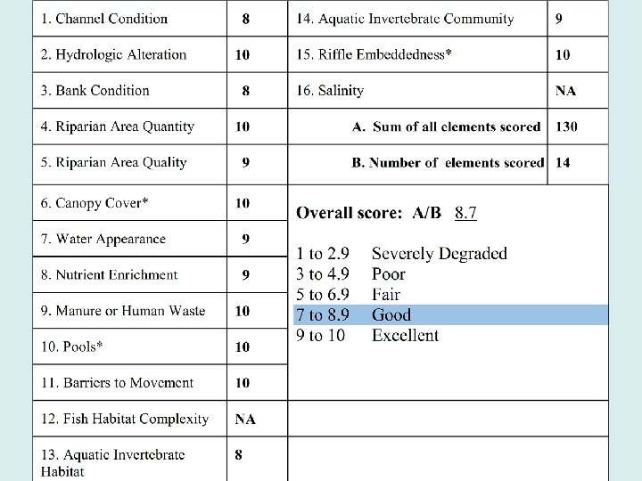
Overall assessment calculations and interpretations • Descriptions for each element, or metric, identify the key features that are used to assign a score to that element –scores range from 10 (excellent) to 0 (poor) • Individual element scores can help identify potential stressors to the stream system. • The final SVAP 2 score indicates the condition of the stream reach assessed, and the quality of the habitat for local species and communities.

Scoring each element in the field

E l e m e n t 1 :


E l e Score of 10 m • Natural, stable channel • Established bank vegetation e • No signs of incision n • No signs of aggradation • Flooded at intervals suitable t for the site. 1 :

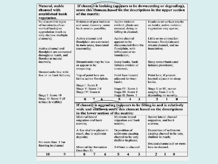
Element 1: Channel Condition Score of 1 Channel is actively aggrading, forming a braided channel with 5 or more bars. Aggraded channel, Score 1 -2 Score of 1 Channel is degrading, little or no connection between floodplain and stream channel. Stage II CEM – Score 1

Incision & Aggradation

Element 1: Channel Condition Natural, stable channel with established bank vegetation. If channel is incising (appears to be downcutting or degrading), score this element based on the descriptions in the upper section of the matrix: If channel is aggrading (appears to be filling in and is relatively wide and shallow), score this element based on the descriptions in the lower section of the matrix:

Element 2: Hydrologic Alteration Score of 10 Bankfull or higher flows occur according to the flow regime that is known for the site, typically every 1 to 2 years, and no dams or water structures are present. Score of 0 -2 Bankfull or higher flows rarely occur, water withdrawals de-water the channel.

Element 3: Bank Condition Score of 10 Banks are stable; protected by roots of natural vegetation, wood or rock; no man-made structures present on bank; no bank failures, and no recreational or livestock access. Score of 0 -2 Banks are unstable; numerous bank failures, unrestricted use by recreational traffic or animals is contributing to longterm bank instability.

Element 4: Riparian Area Quantity Score of 10 Natural plant community extends at least 2 bankfull widths, or over the entire active floodplain and is generally contiguous throughout the stream reach being assessed. Score of 1 Natural plant community extends less than 1/3 of the bankfull width or less than 25% of active floodplain. Vegetation gaps exceed 30% of the estimated length of the stream on the property.

Element 5: Riparian Area Quality Score of 10 Natural and diverse vegetation with composition, density and age structure appropriate for the site. No invasive species and no concentrated flows. Score of 1 -2 Little or no natural vegetation, and evidence of concentrated flows in the riparian area.

Element 6: Canopy Cover – Coldwater Streams Score of 10 50 to 75% of water surface shaded within the length of the stream on landowner’s property Score of 1 < 20% water surface shaded within the length of the stream on landowner’s property.

Element 7: Water Appearance Score of 10 Water in stream is very clear, with no evidence of contamination by oil, wastes, or metal precipitates. Score of 5 Water in stream is occasionally cloudy, especially after storm event, but clears rapidly; objects visible at depth of. 5 to 1 meter; may have slightly green color; no oil sheen on water surface.

Element 8: Nutrient Enrichment Score 9 -10 Clear water along entire reach; little or no algal growth present. Score 0 -2 Thick algal mats dominating stream.

Element 9: Animal or Human Waste Score 10 Livestock do not have access to stream. Score 1 -2 Livestock have unlimited access to stream.

Element 10: Pools Is the reach of stream low gradient, <2%? Or is the stream high gradient, >2%?

Element 10 Pools: Low-Gradient Score 10 More than 2 deep pools separated by riffles, each with greater than 30% of the pool bottom obscured by depth, wood, or other cover. Score 2 -0 Pools absent, but some slow water habitat is available; or reach is dominated by shallow continuous pools or slow water.

Element 10: Pools, High-Gradient Score 10 More than 3 deep pools separated by boulders or wood, each with > than 30% of bottom obscured to view Score 1 -2 Pools absent

Element 11: Barriers to Fish Movement Background information needed: • • Which fish species are present in the stream What is their life history? How high can they jump? Can they tolerate high water temperatures?

Element 11: Barriers to Fish Movement

Element 12: Fish Habitat Complexity 10 or more habitat features available, at least one of which is considered optimal in reference sites (e. g. , large wood in forested streams. ) 10 9 8 to 9 habitat features available. 8 7 6 to 7 habitat features available. 6 5 4 to 5 habitat <4 habitat features available. 4 3 2 1 0

Fish Habitat features include ü ü ü ü ü Logs, large wood Small wood accumulations Deep pools, shallow pools, glides, pockets Large boulders, Small border clusters Overhanging vegetation Undercut banks Riffles Root mats, emergent vegetation Off-channel habitats, including backwaters, oxbows, side-channels, wetlands

Root mats, emergent vegetation Overhanging vegetation

Element 13: Aquatic Invertebrate Habitat At least 9 types of habitat present; a combination of wood with riffles should be present and suitable in addition to other types of habitat. (If non-forested stream, consider reference site’s optimal habitat type needed for this high score. ) 10 9 8 to 6 types of habitat; site may be in need of more wood or reference habitat features, and stable woodriffle sections. 8 7 6 5 to 4 types of habitat present 5 4 3 to 2 types habitat present 3 None to 1 type of habitat present 2 1 0

What lies beneath the water’s surface?

Element 14: Aquatic Invertebrate Community Invertebrate community is diverse and well represented by Group I or intolerant species; one or two species do not dominate. 10 9 8 Invertebrate community is well represented by Group II or facultative species, and Group I species are also present; one or two species do not dominate. 7 6 5 Invertebrate community is composed mainly of Groups II and III, and/or 1 or 2 species of any group may dominate. 4 3 2 Invertebrate community composition is predominantly Group III species and/or only 1 or 2 species of any group is present and abundance is low. 1 0

Group One Taxa: Pollution-sensitive species found in good quality water.

Group Two Taxa: Somewhat pollution tolerant; found in good or fair water quality 10 11 12 13 14 15 16 17 Scud – amphipod Alderfly larva Fish fly larva Damsel fly larva Water snipe larva Cranefly larva Beetle larva Dragon fly larva

Group Three Taxa: Pollution-tolerant organisms can be found in any quality of water 18 clam 19 Aquatic worm 20 Midge fly larva 21 black fly larva 22 leech 23 pond snails 24 other snails

Element 15: Riffle Embeddedness Do not assess this element unless riffles or swift-flowing water and coarse substrates are present or these are natural features that should be present. Gravel or cobble substrates are 10 substrates are -20% embedded. <10% embedded. 10 9 8 7 Gravel or cobble substrates are 21 -30% embedded. 6 5 Gravel or cobble substrates are 31 -40% embedded. 4 3 Gravel or cobble substrates are >40% embedded. 2 1 0

Element 15: Riffle Embeddedness

Assessing Stream Condition: Summary Score one stream reach/assessment • Maximum 15 metrics • ü NOTE that some elements may not be applicable Assign sub-score for each element. • Calculate overall score • SVAP 2 Training Module April 2009

What is next under this scenario?

Overall assessment calculations and interpretations Elements critical to overall stream health üChannel Condition üBank Condition üHydrological Alteration Difficult to assess accurately Scores of less than 5 üMay indicate substantial channel adjustments are occurring üMay warrant a quantitative assessment by well-trained specialists

“No Regrets” Management Actions • Riparian buffers/stabilizing vegetation • Improved agricultural practices • Don’t develop floodplains Slow down the water
- Slides: 51