Sustainable Land Use Planning laws and regulations Dr

Sustainable Land Use Planning, laws and regulations Dr. Asghar Naeem Head of Urban & Regional Planning Department National University of Sciences and Technology (NUST), Sector H-12, Islamabad

Session Objectives v. To develop understanding of urban sprawl management and slums upgradation policies of the government v. To highlight the need of green spaces for urban sustainability and promote mixed land use v. To give an overview of Land Use Rules

What is Land Use Planning? Land Use: v It refers to the manner of utilization of land, including its allocation, development and management. Land Use Planning v Refers to the rational and judicious approach of allocating available land resources to different land using activities and for different functions consistent with the overall development vision/goal of a particular city v It also refers to a document embodying a set of policies accompanied by maps and similar illustrations which represent the community desired pattern of population distribution and a proposal for the future allocation of land to the various land-using activities

What is Land Use Planning? Sustainable Land Use Planning v Sustainable use of land means to overcome the rising issues of urbanization by managing land use in a manner that the needs of the present communities are met without compromising the needs of the future communities

Islamabad Zone Map 5
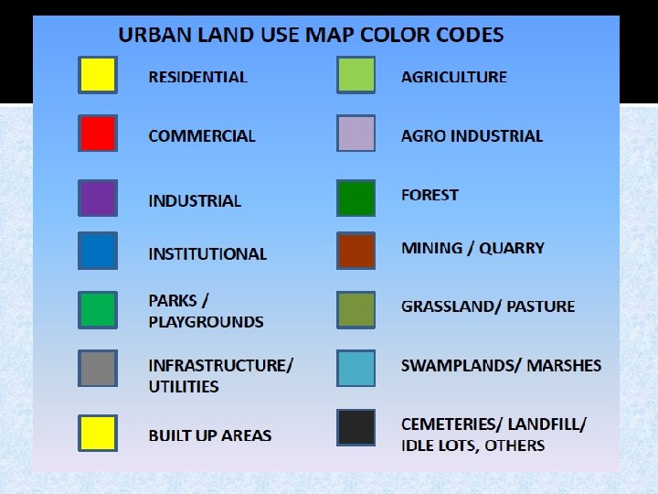

Example of land-use Map 7

Land Use Proportions for Small/Medium Housing Schemes Use of land percentage 1 Residential 45 - 52 2 Commercial 2 -3 3 Education, health and other community facilities 7. 5 – 10 4 Roads/streets 25 - 30 5 Open spaces 5 – 7. 5 6 Others, including grave yards, equivalent reserves 2 -5 Source: National Reference Manual on Planning & Infrastructure Standards, Govt. of Pakistan, 1986

Guidelines for Land Allocation to Zones in Design of a New Town Design Size (Ultimate population Reside ntial Zones Industr Comm ial ercial Zones Instit Arterial ution circulatio al n+ Terminal s Comm Grave unity yards open spaces Protec ted/res erved areas 100, 000+ 40 -45 2 -10 2 -3 3 -5 15 -20 4 -6 2 -3 15 -25 50 -99000 40 -45 2 -15 2 -3 3 -5 10 -15 3 -5 2 -3 15 -25 Source: National Reference Manual on Planning & Infrastructure Standards, Govt. of Pakistan, 1986

Urbanization – A key factor influencing cities Percentage of Urban Population in different periods 80 60 30 20 66 50 40 20 30 20 15 20 s 50 19 18 00 s 0

Urbanization – Two sides of the picture v Urbanization has its own benefits ¯job provision opportunities ¯ reduction in poverty ¯ innovation, entrepreneurship ¯ economies of scale v Disadvantages ¯ tremendous demand for extra land to accommodate the growing population ¯ demand for civic amenities such as energy, water, sanitation, education, health Source: http: //www. fbtimepass. com/uploadedimage s/TWO-SIDES-OF-ME-Must-Read. jpg

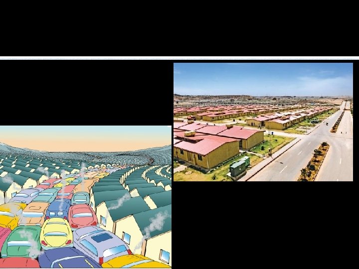
Urban Sprawl characteristics v urban sprawl started in the 2 nd half of the 20 th century v The phenomenon of sprawl has been experienced by almost all those cities of the world that gained some prosperity v a form of urban development characterized by a number of indicators such as : ¯low density of housing and commercial buildings ¯ excessive use of privately owned automobiles ¯ lack of public transport ¯ segregated development ¯ gated communities on the fringe of the city ¯Traffic congestion Source: ¯ environmental degradation http: //www. fbtimepass. com/uploadedimage s/TWO-SIDES-OF-ME-Must-Read. jpg

Urban Sprawl: Advantages & Disadvantages v it makes cheap land available to accommodate urbanization v symbol of prosperity and adds value to social life v There a plethora of costs/disadvantages associated with urban sprawl such as: ¯ excess travel ¯congestion ¯ energy costs ¯ environmental costs ¯ inflated costs of infrastructure/services provision ¯ loss of open spaces ¯ down town decay Source: http: //www. fbtimepass. com/uploadedimage s/TWO-SIDES-OF-ME-Must-Read. jpg

Illustration of urban sprawl Source: Bertaud, 2004 In World Bank report, 2011
: 906 Density: 888 person/Sq.")
Islamabad: Pop in 2011: 1. 7 million Area (Sq. Km): 906 Density: 888 person/Sq. Km Kuala Lumpur: Pop : 1. 7 million Area ( Sq. Km): 243 Density: 6, 890 person/ square km Source: http: //issuu. com/anwar_townplan/docs/townplan_02

Compact Development – A way of dealing with urban sprawl v The word “Compact City” was coined by George Dantzig & Thomas Saaty in 1973 in their book entitled Compact City: A Plan for a Livable Urban Environment. v a sustainable city “must be of a form and scale appropriate to walking, cycling and efficient public transport and with a compactness that encourages social interaction” (Elkin et al. , 1991) v fundamental characteristics namely of a compact city: ü mixed use development ü emphasis on public transportation üurban regeneration, üstrict control on development outside the city boundary üpedestrian friendly pavements

Examples of compact & sustainable cities v Curitiba - the capital and largest city of the Brazilian state of Paraná ¯ Population: 1, 760, 500 people as of 2010 ¯ Density: 4, 062/km 2 ¯ Metropolitan area : 26 municipalities with a total population of over 3. 2 million Source: wikipedia http: //upload. wikimedia. org/wikipedia/commons/thumb/e/e 7/Curiti ba_Centro. jpg/800 px-Curitiba_Centro. jpg

Examples of compact & sustainable cities v Amsterdam - the capital and largest city of the Netherlands ¯ Population: 813, 562 ¯ Density: 4, 908/km 2 ¯ Metropolitan area : 2. 33 million Source: http: //www. jordaanweb. nl/HTMLengels/indexcom. htm? /HTMLeng els/jordaan. htm&1

Open Spaces v Open spaces, recreational and sports facilities are an integral part of urban life and help make cities attractive and livable places v There are two types of open spaces 1. Active open spaces Amusements parks, sports grounds, exhibition grounds and open-air theater 2. Passive Open Spaces national parks, gardens and green belts along roads etc Source: http: //www. fbtimepass. com/uploadedimage s/TWO-SIDES-OF-ME-Must-Read. jpg

Open Space Standards Design Size (Ultimate population Reside ntial Zones Industr Comm ial ercial Zones Institu tional Arteria l circula tion + Termin als Comm unity open spaces Grave yards Protec ted/res erved areas 100, 000+ 40 -45 2 -10 2 -3 3 -5 15 -20 4 -6 2 -3 15 -25 50 -99000 40 -45 2 -15 2 -3 3 -5 10 -15 3 -5 2 -3 15 -25 City Open Space London 40 m² person Melbourne 20 m²per person Toronto 20 m² person Source: http: //www. fbtimepass. com/uploadedimage s/TWO-SIDES-OF-ME-Must-Read. jpg

Slums- Emblems of urban poverty Most cities have been unprepared to provide housing and basic services for their rapidly increasing population. More than half the population in many cities and towns of developing countries cannot afford formal market housing and, thus, accommodate themselves in informal settlements or slums.
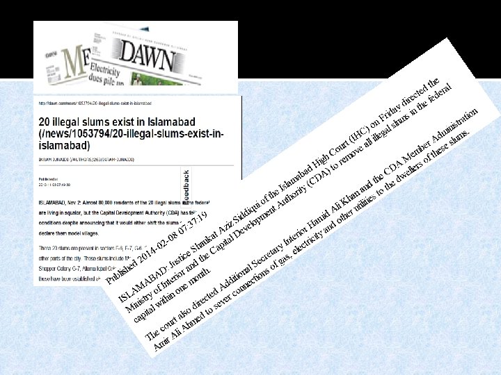

Katchi Abadis in Islamabad v There are 10 recognised katchi abadis in Islamabad with 3805 housing units in 2004, which has risen to 4814 housing units as per present surveys conducted by CDA in 2014. v Five of these katchi abadis are located in right of way of roads, plots or green areas v there were 24 illegal katchi abadis which have encroached precious CDA land. v After a number of operations for removal of illegal Katchi abadis all around the city however still there are 14 illegal Katchi abadis having 1727 dwelling units as detailed below: -

Steps taken by CDA to Overcome the issue v Junejo Government announced in 1985, award of ownership to the dwellers of katchi abadis of Pakistan but it saw little success v CDA opposed the award of ownership to the dwellers of katchi abadis in Islamabad at the existing location and felt that giving ownership rights to the dwellers of katchi abadis would be: - Violation of Master Plan - Deprive CDA of very costly land - Lead to establish isolated and downgraded enclaves.

Steps taken by CDA to Overcome the issue v. Limiting the growth of existing Katchi abadis v. Eviction of those abadis which are in CDA’s planned plots or in sensitive areas. v. Rehabilitation of katchi abadis on existing site. v. Redevelopment of Kachi Abadi such as G-8/1 - a successful model of CDA. v Model Urban Shelter Project at Ali Pur Farash (2001) - a partially successful project

Strategy for Increasing the supply of land housing for the poor Availability of affordable large plot for housing construction Expand the affordable housing supply Limiting the growth of slums Subsidized land supply Land banking Unit size requirements New towns Unlock unused or underused governmentowned land Land readjustment
 in Ahmedabad, Gujarat")
Land Readjustment (Town Planning Scheme) in Ahmedabad, Gujarat
- Slides: 28