Sustainable Development Goals and the Importance of Hydrography

Sustainable Development Goals and the Importance of Hydrography Jamie Mc. Michael-Phillips, Head of Partnering & Engagement (Asia Pacific)

What is Hydrography ? IHO Definition “Hydrography is the applied science which deals with the measurement and description of the physical features of oceans, seas, coastal areas and inland waters, as well as with the prediction of their change over time. ”

Blue Economy World Bank definition “Sustainable use of ocean resources for economic growth, improved livelihoods, and jobs while preserving the health of ocean ecosystem. ”

Maritime Trade • 80% of all trade in goods transported by sea • Containerised trade more than tripled in last 10 years • 48 million twenty-foot equivalent units (TEUs)
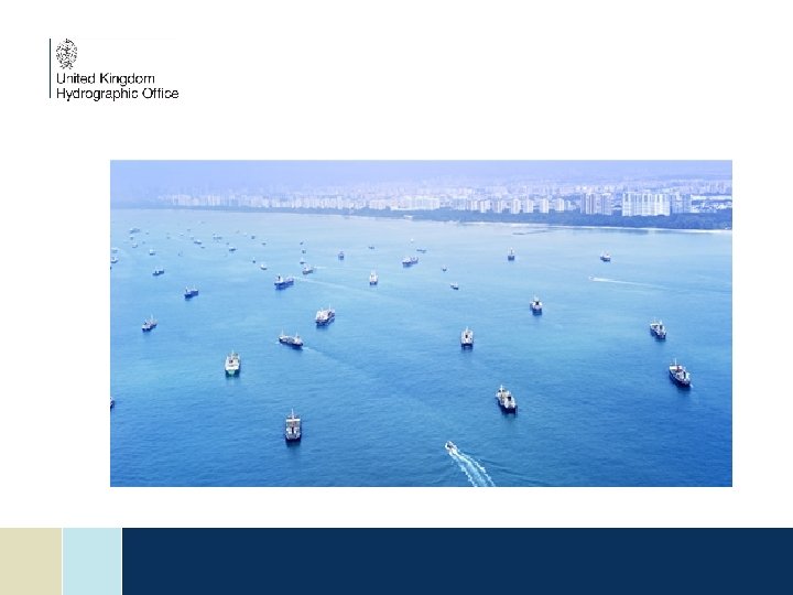

But …. . It is much more than simply trade ……. .

Hydrography and the Bigger Picture Habitat Mapping Inundation mapping Disaster preparedness MPAs Fisheries Management Disaster mitigation Coastal Zoning Oceans Governance Hydrography A keystone data type for safe navigation plus much more Coastal land use planning Climate change resilience

Issues with Data Age and Resolution 1800 s Today The age of the survey indicates which method has been used

Old data does not support the needs of the Blue Economy • It is largely inadequate for safe navigation • It is largely inadequate for modelling • It does not support fisheries management • It does not support knowledge and protection of key habitat areas • It does not support resource exploitation • It can discourage some shipping from visiting

11 IMO/IHO
 Reg.")
SOLAS and International Obligations SOLAS Chapter V: Safety of Navigation (Part of IIIC) Reg. 4 Navigational Warnings Each Contracting Government shall take all steps necessary to ensure that, when intelligence of any dangers is received from whatever reliable source, it shall be promptly brought to the knowledge of those concerned and communicated to other interested Governments In January 2016 the IMO Mandatory Audit Programme commenced
 Reg.")
SOLAS and International Obligations SOLAS Chapter V: Safety of Navigation (Part of IIIC) Reg. 9 Hydrographic Services Contracting Governments undertake to arrange for the collection and compilation of hydrographic data and the publication, dissemination and keeping up to date of all nautical information necessary for safe navigation…. Contracting Governments undertake to co-ordinate their activities to the greatest possible degree in order to ensure that hydrographic and nautical information is made available on a world-wide scale as timely, reliably, and unambiguously as possible. In January 2016 the IMO Mandatory Audit Programme commenced

Phase 1 Collection and dissemination of Maritime Safety Information Phase 2 Hydrographic surveying prioritisation and capability Phase 3 Production of paper charts, ENCs and nautical publications Hydrographic Governance IHO Capacity Building Maturity Model

UN Sustainable Development Goals

UN Sustainable Development Goals Can we afford not to do hydrography? n What are the SDGs? n What are the Key SDGs? n How does Hydrography fit? n What are the challenges for incorporating hydrography into SDGs? n Summary

UN Sustainable Development Goals

SDG 14 Life Below Water Conserve and sustainability use the oceans, seas and marine resources for sustainable development. Key Target: 14. 7 By 2030 increase the economic benefits to small island developing states and least developed countries from the sustainable use of marine resources, including through sustainable management of aquaculture and tourism.

SDG 9 Industry, Innovation and Infrastructure Build resilient infrastructure, promote inclusive and sustainable industrialization and foster innovation. Key Target: 9. 1 Develop quality, reliable, sustainable and resilient infrastructure, to support economic development and human well being with a focus on affordable and equitable access for all.

How does Hydrography fit into the SDGs?

Challenges for Incorporating Hydrography? There are some very real challenges for incorporating hydrography in to delivery of SDGs: n Hydrography does not always attract attention n Seabed mapping is a starting component not an outcome in its own right n National HOs are rarely asked to contribute to cross government policy n The seabed is invisible to the public and therefore not politically attractive

Challenges for Implementing SDGs? The key challenges for implementation represents an opportunity and spatial data …. . If a marine protected area is delimited without an understanding of the seabed, it may unnecessarily hinder access to a port

Challenges for Implementing SDGs? The key challenges for implementation represents an opportunity and spatial data …. . If a new port is developed without an understanding of the seabed, it may damage a habitat essential for food security

Challenges for Implementing SDGs? The key challenges for implementation represents an opportunity and spatial data …. . If both activities are approached with a good understanding of the seabed, then both can be achieve sustainably

UN Sustainable Development Goals

SDG Summary Key considerations going forward: n The SDGs offer an opportunity to raise the profile of our work n Some SDGs will not be sustainably implemented without seabed mapping n Incorporation of seabed mapping into the delivery of SDGs will raise global awareness and generate funding opportunities n The will only happen if we get better at educating our audience

Summary n Improving data quality will reduce liability and risk and can also increase vessel traffic/size n Efforts to raise the profile of hydrography within government are never wasted n Hydrographic data is wider than just producing SOLAS products eg. delivery of SDGs, Blue Economy, coastal zone management etc.

Questions?
- Slides: 28