Surface Water Surface water notes Where is all


 into the")


 Velocity: (slow,")
 Velocity: (slow, moderate,")
 Velocity:")


- Slides: 20
Surface Water
Surface water notes: Where is all the water? • • • 97. 5% in Oceans 1. 8 % in Ice. 63% in groundwater. 007% in salty lakes and streams. 009% in fresh water lakes and streams. 0001% in the atmosphere
Where is all the fresh water? • 73. 9% in ice • 25. 7% in groundwater • . 36% in freshwater lakes and streams • . 04% in the atmosphere
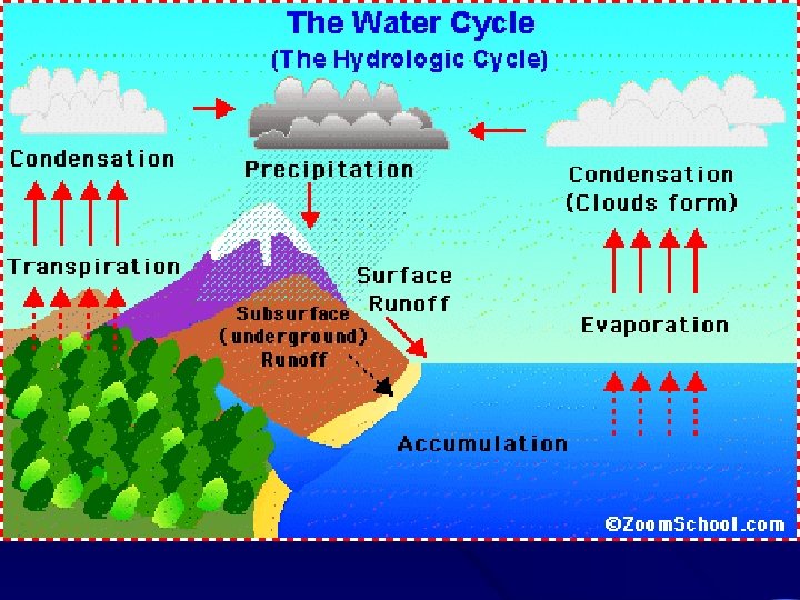
What happens to water when it rains? • It either infiltrates (soaks) into the ground or • It remains on the surface
Watersheds • Its an area that drains to a stream • Watershed boundaries or divides are high places • First order streams have small watersheds 2. 5 km • Mississippi River basin is a tenth order stream. It drains 320 million sq. miles
Surface Water James River York River Potomac River Susquehanna River Rappahannock River All of the rivers listed above drain into the: Chesapeake Bay Watershed
Drainage Divide Label your River diagram in your notes Meander Flood Plain
Streams are constantly changing? • Young streams flow straight, smaller, have rapids, faster • Mature streams meander or curve • Old streams are widest, carry the most water, slower
Young River Characterized by: _____ Slope: Slope (steep, moderate, or gentle? ) Velocity: (slow, moderate, or fast? ) Erosion rate: (slow, moderate, or fast? )
Mature River Characterized by: _____ Slope: (steep, moderate, or gentle? ) Velocity: (slow, moderate, or fast? ) Erosion rate: (slow, moderate, or fast? )
Old River Characterized by: _____ Old River Slope: (steep, moderate, or gentle? ) Velocity: (slow, moderate, or fast? ) Erosion rate: (slow, moderate, or fast? )
Cut Bank- where the bank is eroding away, faster moving water Meanders: Curves in Rivers Point Bar- the inside of the curve where sediment is being deposited. Slower water with less velocity. Cut Bank up close
How Rivers become straight again? • A meander forms • Over time, the meander gets curvier • It gets so curvy that the two cut banks meet each other • Eventually none of the water goes around the meander anymore • The leftover lake is an Oxbow Lake
What is a flood plain?
Floodplains • Flat or gently sloped region around the river, in which the river flows during flooding • The larger the river, the bigger the flood plain • Deltas: Flood plains at the mouths of rivers are known as deltas • Alluvial fans form when rivers drop the soil at the base of the mountain.
Rivers carry sediment • Three types of loads – bed load at bottom include sand, gravel, & pebbles, – suspended loads in the middle include clay and silt – solution includes dissolved materials The faster the velocity of the water, the greater the load (MORE EROSION!!!)
Factors that influence flooding 1. Rainfall amounts 2. Topography 3. Type of Soil – how permeable – how saturated 4. Amount of Impermeable land area 5. Vegetation A 10 year flood may occur once every ten years or has a 1/10 (10%) chance of occurring yearly
Glaciers carve U - shaped valleys ri. Vers carve Vshaped Valleys
Flood Frequency Curves R= N+1/r Are we at risk for flooding?