Surface Water Surface Water Movement Water Cycle Earths


 • Underground deposits • As")

 Straight: narrow channel, high velocity, high erosion, not much deposition")
 Braided: wide, shallow channel with bars (deposits of sediment) in")
 Meandering: narrow, deep channels with pronounced sinuous curves • Bending")


 that has")


- Slides: 25
Surface Water
Surface Water Movement • Water Cycle • Earth’s water supply is recycled in a continuous process called the water cycle • Water molecules evaporate from a body of water or the surface of Earth • Condense into cloud droplets • Fall as precipitation back to Earth’s surface • Infiltrate the ground **The cycle repeats
Runoff • Runoff: water flowing downslope along Earth’s surface • Runoff might reach a stream, river or lake, it might evaporate, or accumulate as puddles and infiltrate the ground • For water to enter the ground, there must be large enough pores in the soil and rock
Streams • Stream: a body of water, confined to a channel, that runs downhill under the influence of gravity • 3 functions of streams: • Erode • Transport • Deposit • Goal of a stream is to get water to BASE LEVEL • Lowest erodible point (sea level, resistant rock level)
Stream Systems • Tributaries: rivers that flow into other streams • Example: The Ohio River is a tributary of the Mississippi River • Watersheds and divides • Watershed: all of the land area whose water drains into a stream system • Can be large or small • Divide: a high land area that separates one watershed from another • In a watershed, the water flows away from the divide, as this is the high point of the watershed
Stream Load • Stream Load: the material that a stream carries 1. Materials in suspension - Sediment light enough to be carried by the turbulence of a stream’s moving water - Silt, clay, & sand size particles - Rapidly moving water carries larger particles in suspension than slowly moving water 2. Bed load - Large, heavy particles that travel on the streambed - The faster the water moves, the larger the particles it can carry 3. Materials in solution - Materials are dissolved in a stream’s water
Stream Carrying Capacity • Carrying Capacity: the ability of a stream to transport material • Depends on VELOCITY and AMOUNT OF WATER • Slope, depth, and width all affect the speed and direction the water moves • Discharge: the measure of the volume of stream water that flows past a particular location within a given period of time • Usually expressed in cubic meters per second (m 3/s) • Discharge = average width x average depth x average velocity • As a stream’s discharge increases, it capacity also increases
Floods • Flood: when water spills over the sides of a stream’s banks onto the adjacent land • Floodplain: the flat area that extends out from a stream’s bank and is covered by excess water during times of flooding • Floodwater carries along a great amount of sediment eroded from the stream channel • As floodwater recedes, the sediment is deposited and over time accumulates and creates natural levees
Formation of Levees
Stream Development • Stream Channels • Headwater: the region where water first accumulates to supply a stream • Usually high in the mountain • Stream Channel: narrow pathway carved into the sediment or rock by moving water • Channel widens and deepens as more water accumulates • Stream Bank: Sides of channel, holds water within channel • Mouth: the area of the stream that leads into the ocean or another large body of water
Formation of Stream Valleys • The driving force of a stream is gravity • Energy of a stream comes from the movements of water downslope • Stream gradient: downhill slope of the streambed • Steep gradient = rapid moving stream • Gradient gradually decreases downstream • Gradient depends of base level • Base level: the elevation at which a stream enters another stream or body of water • Lowest base level possible is sea level
Stream Development • Supply of Water • Precipitation (rain) • Underground deposits • As a stream develops, it changes in width and size and shapes the land over which it flows • Young steams actively erode a path towards base level • As a stream approaches base level, it has less energy, so it tends to erode at the sides of the stream (broad valleys with gentle slopes)
Stream Erosion • Streams are actively eroding a path through the sediment, and forming a V-shaped valley • Steep sides • Example: Colorado River & the Grand Canyon • Channel shape and roughness • Anywhere the water touches the channel, there is friction • Wide or bumpy (more friction) = slower • Steeper or smooth = faster
Types of Streams 1) Straight: narrow channel, high velocity, high erosion, not much deposition • Seen in mountains • Moves large boulders
Types of Streams 2) Braided: wide, shallow channel with bars (deposits of sediment) in center of stream • Occur in deserts and mountain regions with snow
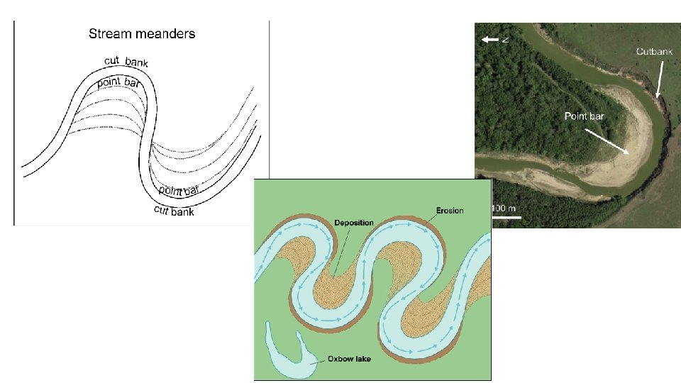
Types of streams 3) Meandering: narrow, deep channels with pronounced sinuous curves • Bending and curving in stream channel • Max velocity is in the deepest sections (located on outside of bend) • Outside of the curve erodes, inside deposits sediment • Creates cut banks (erodes) and point bars (deposits)
Meandering Rivers • Meaner cutoff: after enough winding, it is common for a stream to cut off a meander and flow along a straighter path • Oxbow lake: the “blocked-off” meander
Stream Deposition • The velocity of a stream determines how much sediment it can transport • Rapid flowing streams have more energy transport larger sediment • Slow flowing streams have low energy minimal transport, more deposition • Depositional Features: 1. Bars 2. Alluvial Fans 3. Deltas
Bars • An elevated region of sediment (such as sand or gravel) that has been deposited by the flow • Bars are typically found in the slowest moving, shallowest parts of rivers and streams, and are often parallel to the shore
Alluvial Fans • A triangle-shaped deposit of gravel, sand, and even smaller pieces of sediment, such as silt • Usually created as flowing water interacts with mountains, hills, or the steep walls of canyons.
Deltas • The triangular deposit that forms where a stream enters a large body of water • Water and sediment leave the river mouth and enter slowermoving or standing water
Lakes • Lake: body of water surrounded by land • Lakes form in different ways in surface depression and in low areas • Cut-off meanders • Sediment blocks from landslides or other sources • Glacial lakes (glaciers carved out the land during the ice age) • Moraine dammed lakes • Kettles – melted blocks of ice in an outwash plain
Wetlands • An area of land that is covered with water for part of the year 1. Bogs: - Not stream fed, receive water from precipitation - Waterlogged, acidic soils 2. Marshes: - Form along the mouths of streams - Lush growth of marsh grasses 3. Swamps: - Low-laying areas located near streams - Can develop from marshes that are now filled with shrubs and trees
Wetlands and Water Quality • Wetlands play a vital role in improving water quality • Serve as a filtering system that traps pollutants, sediments, and bacteria contained in water sources • Vital habitat for wildlife • From the late 1700 -mid 1980, the US lost about 50% of its wetlands