Summary of NOAAs 2010 Hurricane Field Program IFEX
- Slides: 14

Summary of NOAA's 2010 Hurricane Field Program (IFEX) Robert Rogers – 2010 HFP Field Program Director 1

Intensity Forecasting Experiment (IFEX; Rogers et al. , BAMS, 2006) IFEX intended to improve prediction of TC intensity change by: 1) collecting observations that span TC life cycle in a variety of environments for model initialization and evaluation 2) developing and refining measurement technologies that provide improved realtime monitoring of TC intensity, structure, and environment 3) improving understanding of physical processes important in intensity change for a TC at all stages of its life cycle These goals provide the linkage between observations, modeling, and theory 2 that form the foundation of the Hurricane Forecast Improvement Project (HFIP)

Focus areas for 2010 IFEX goal 1: Collecting observations for model initialization/evaluation • Tail Doppler radar • Synoptic surveillance with Global Hawk • HWRFx/HFIP real-time runs and HEDAS data assimilation IFEX goal 2: Developing and refining measurement technologies • • Coyote low-level UAS Doppler Wind Lidar Ocean winds/AWRAP Global Hawk high-level UAS (partnership with NASA) IFEX goal 3: Improving understanding • Genesis • Rapid Intensity Change • TC-Ocean interaction • Saharan Air Layer • Landfall and Inland Decay • TC/AEW Arc Cloud • Hurricane PBL Entrainment Flux • Aerosol/Cloud Droplet measurement 3

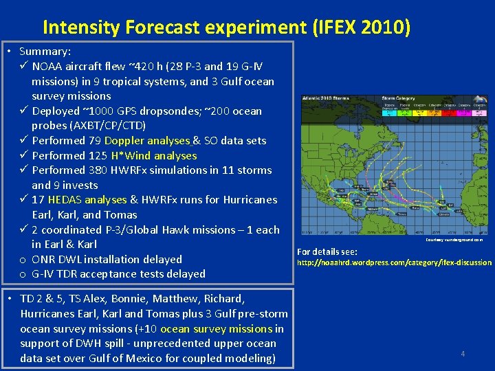
Intensity Forecast experiment (IFEX 2010) • Summary: ü NOAA aircraft flew ~420 h (28 P-3 and 19 G-IV missions) in 9 tropical systems, and 3 Gulf ocean survey missions ü Deployed ~1000 GPS dropsondes; ~200 ocean probes (AXBT/CP/CTD) ü Performed 79 Doppler analyses & SO data sets ü Performed 125 H*Wind analyses ü Performed 380 HWRFx simulations in 11 storms and 9 invests ü 17 HEDAS analyses & HWRFx runs for Hurricanes Earl, Karl, and Tomas ü 2 coordinated P-3/Global Hawk missions – 1 each in Earl & Karl o ONR DWL installation delayed o G-IV TDR acceptance tests delayed • TD 2 & 5, TS Alex, Bonnie, Matthew, Richard, Hurricanes Earl, Karl and Tomas plus 3 Gulf pre-storm ocean survey missions (+10 ocean survey missions in support of DWH spill - unprecedented upper ocean data set over Gulf of Mexico for coupled modeling) Courtesy wunderground. com For details see: http: //noaahrd. wordpress. com/category/ifex-discussion 4

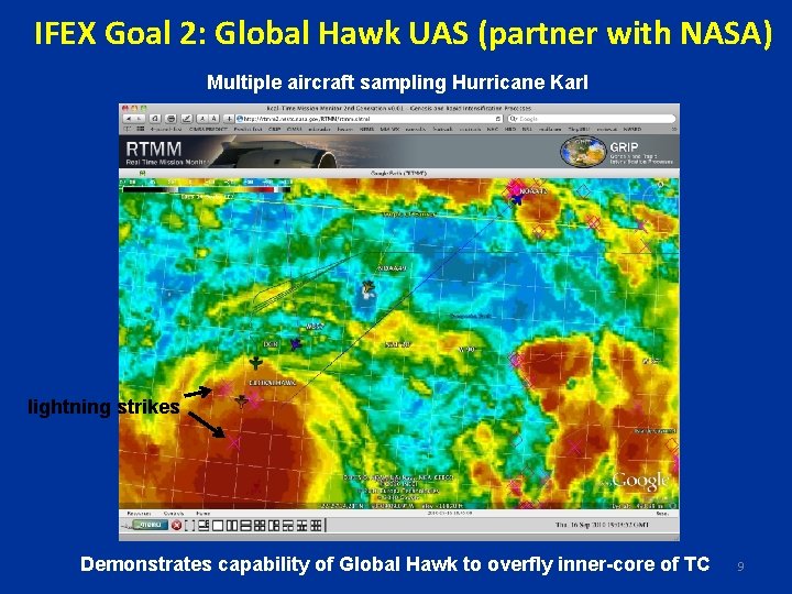
Interactions with other experiments • NASA GRIP (Genesis and Rapid Intensification Processes, 8/15 -9/30) • DC-8 -- based in Ft. Lauderdale, GH -- based in Dryden, CA • Scott Braun, Ed Zipser, Gerry Heymsfield aircraft leads • GH flew missions over Hurricanes Earl and Karl, good coverage of RI stage of Karl • NSF PREDICT (PRE-Depression Investigation of Cloud systems in the Tropics, 8/15 -9/30) • G-V – based in St. Croix • Mike Montgomery, Chris Davis, Andy Heymsfield, Lance Bosart leads • Excellent dropsonde coverage in pre-genesis stage of Karl 5

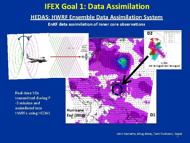
IFEX Goal 1: Data Assimilation HEDAS: HWRF Ensemble Data Assimilation System En. KF data assimilation of inner core observations D 2 20° Vr SOs 22 Z 29 August-01 Z 30 August Real-time SOs transmitted during P -3 mission and assimilated into HWRFx using HEDAS D 2 Hurricane Earl (2010) D 1 John Gamache, Altug Aksoy, Tomi Vukicevic, Gopal 6

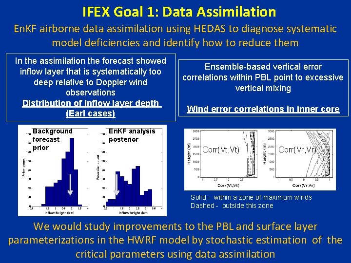
IFEX Goal 1: Data Assimilation En. KF airborne data assimilation using HEDAS to diagnose systematic model deficiencies and identify how to reduce them In the assimilation the forecast showed inflow layer that is systematically too deep relative to Doppler wind observations Distribution of inflow layer depth (Earl cases) Background forecast prior Ensemble-based vertical error correlations within PBL point to excessive vertical mixing Wind error correlations in inner core En. KF analysis posterior Corr(Vt, Vt) Corr(Vr, Vr) Solid - within a zone of maximum winds Dashed - outside this zone We would study improvements to the PBL and surface layer parameterizations in the HWRF model by stochastic estimation of the critical parameters using data assimilation

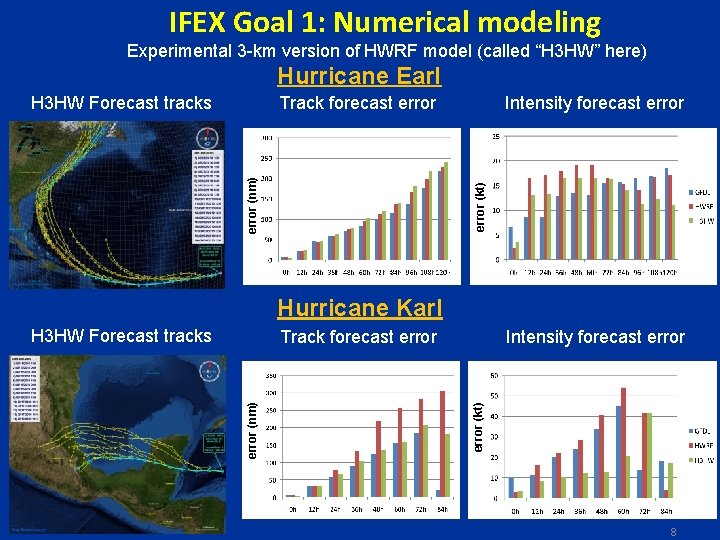
IFEX Goal 1: Numerical modeling Experimental 3 -km version of HWRF model (called “H 3 HW” here) Hurricane Earl H 3 HW Forecast tracks Intensity forecast error (kt) error (nm) Track forecast error Hurricane Karl H 3 HW Forecast tracks Intensity forecast error (kt) error (nm) Track forecast error 8

IFEX Goal 2: Global Hawk UAS (partner with NASA) Multiple aircraft sampling Hurricane Karl lightning strikes Demonstrates capability of Global Hawk to overfly inner-core of TC 9

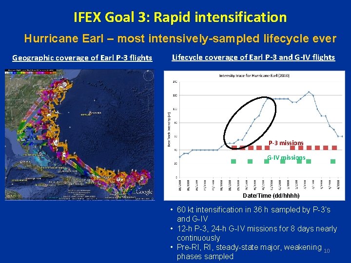
IFEX Goal 3: Rapid intensification Hurricane Earl – most intensively-sampled lifecycle ever Geographic coverage of Earl P-3 flights Lifecycle coverage of Earl P-3 and G-IV flights P-3 missions G-IV missions Date/Time (dd/hhhh) • 60 kt intensification in 36 h sampled by P-3’s and G-IV • 12 -h P-3, 24 -h G-IV missions for 8 days nearly continuously • Pre-RI, steady-state major, weakening 10 phases sampled

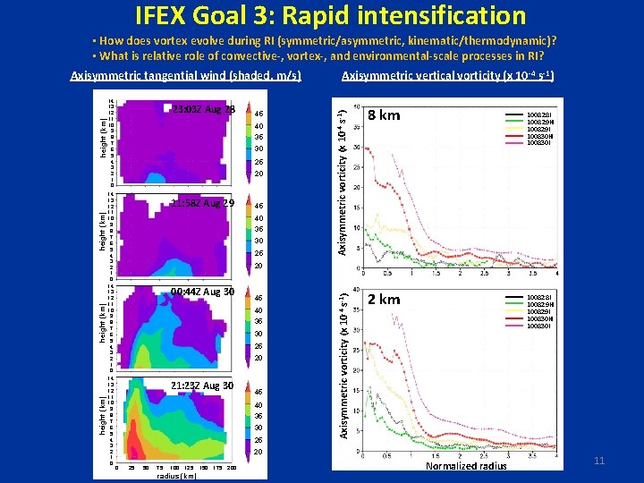
IFEX Goal 3: Rapid intensification • How does vortex evolve during RI (symmetric/asymmetric, kinematic/thermodynamic)? • What is relative role of convective-, vortex-, and environmental-scale processes in RI? 14 13 12 11 10 9 8 7 6 5 4 3 2 1 0 23: 03 Z Aug 28 45 40 35 30 25 20 11: 58 Z Aug 29 45 40 35 30 25 Axisymmetric vorticity (x 10 -4 s-1) 14 13 12 11 10 9 8 7 6 5 4 3 2 1 0 Axisymmetric vertical vorticity (x 10 -4 s-1) 8 km Axisymmetric vorticity (x 10 -4 s-1) height (km) Axisymmetric tangential wind (shaded, m/s) 2 km 100828 I 100829 H 100829 I 100830 H 100830 I 20 00: 44 Z Aug 30 45 40 35 30 25 20 21: 23 Z Aug 30 45 40 35 30 25 100828 I 100829 H 100829 I 100830 H 100830 I 20 0 25 50 75 100 125 radius (km) 150 175 200 Normalized radius 11

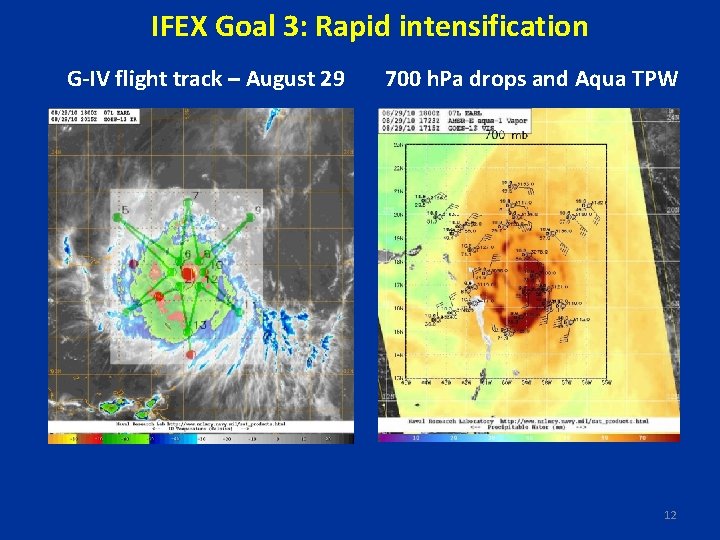
IFEX Goal 3: Rapid intensification G-IV flight track – August 29 700 h. Pa drops and Aqua TPW 12

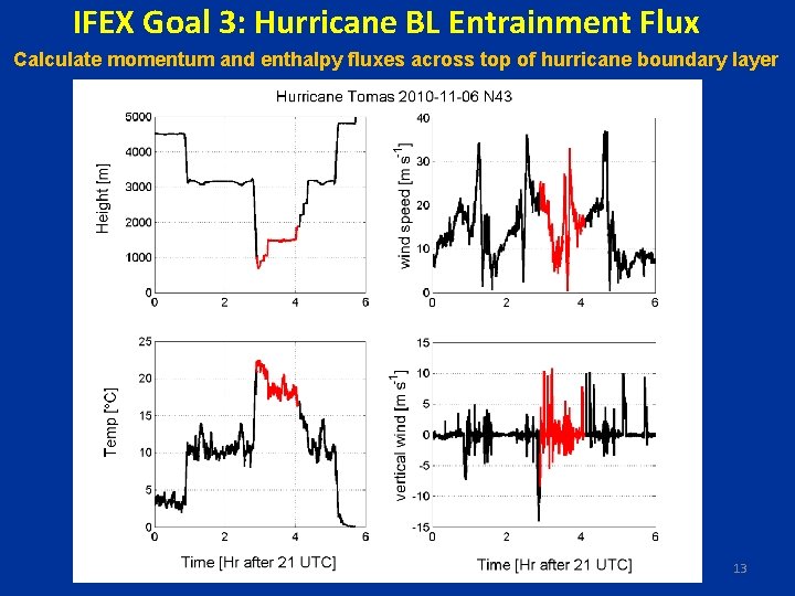
IFEX Goal 3: Hurricane BL Entrainment Flux Calculate momentum and enthalpy fluxes across top of hurricane boundary layer 13

Summary • Several IFEX 2010 objectives accomplished • Data assimilation system, numerical model advancing as innercore data collection continues and model evaluation of innercore structures begins • Viability of new observing technologies demonstrated by working with NASA partners • Excellent multi-scale dataset for RI collected in Hurricane Earl • near-continuous sampling of major portion of lifecycle, including significant RI event 14