
Summary for Water Vapor Water vapor is the

- Slides: 44
Summary for Water Vapor • Water vapor is the single largest greenhouse gas in the air; • RH, q, and PW are often used to quantify atmospheric humidity and water vapor content; • Surface RH varies little over the oceans (~78 -82%), ranges from >82% over the Amazon to <30% over deserts. The factors that control RH are not well understood, although large-scale subsidence seems to have a major impact on upper tropospheric RH; • Water vapor feedback is a strong positive feedback that amplifies the radiative forcing by a factor of ~2; • Limited data suggest that atmospheric water vapor content increases with T, approximately following the Clausius-Clapeyron relation, which implies small changes in RH; • Models suggest global PW increases by ~9%/K, slightly above the C-C rate but consistent with the SSMI satellite data (8. 9%/K); • Models suggest a slight increase (~1%) in near-surface RH and a small RH decrease (1 -4%) in the sub-tropical subsidence region and 1 -4% increases over the equator and mid-high latitude troposphere during the 21 st century;
Summary of Clouds and Aerosols • Clouds are classified by shapes (cumulus, stratus, cirrus, and nimbus), formation (convective and stratiform), or height (high, middle and low clouds). • Generally, there are more clouds over oceans than over land, more clouds over the high-latitudes than the low-latitudes. • Clouds reflect and absorb sunlight (cooling effect on surface) and block outgoing longwave radiation (warming effect); • SW cooling dominates over LW warming effect for low clouds, but the opposite is true for high clouds. Why? • Globally, the SW cooling effect is about 50 W m-2 and LW warming effect is about 30 W m-2, resulting in a net cooling of ~20 W m-2, predominately over the northern mid-latitudes. • Under GHG-induced global warming, most models suggest a decrease in low and mid-level clouds, especially over the mid-latitudes and subtropics and an increase in high clouds due to enhanced tropical convection. • CMIP 3 models show a CRF change from -2. 2 to 1. 6 W m-2 in the 21 st century, a major source of uncertainty for the future climate. • Aerosols affect climate directly through their radiative effects and indirectly through their impact on clouds albedo and lifetime. • How aerosols have contributed to the 20 th century climate is still a very active research area.
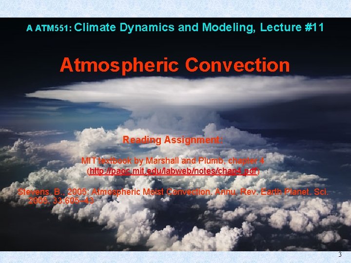
A ATM 551: Climate Dynamics and Modeling, Lecture #11 Atmospheric Convection Reading Assignment: MIT textbook by Marshall and Plumb, chapter 4 (http: //paoc. mit. edu/labweb/notes/chap 4. pdf) Stevens, B. , 2005: Atmospheric Moist Convection. Annu. Rev. Earth Planet. Sci. 2005. 33: 605– 43 3
Outline of Today’s Lecture • • Atmospheric Convection: - Definition Roles – Radiative-convection equilibrium Types Distributions Diurnal cycle • Quantifying Convection: - Lapse rates Instability Buoyancy CAPE and CIN Lateral mixing -- entrainment and detrainment Heating rates Q 1 and Q 2
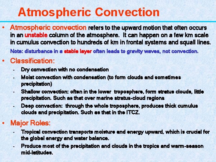
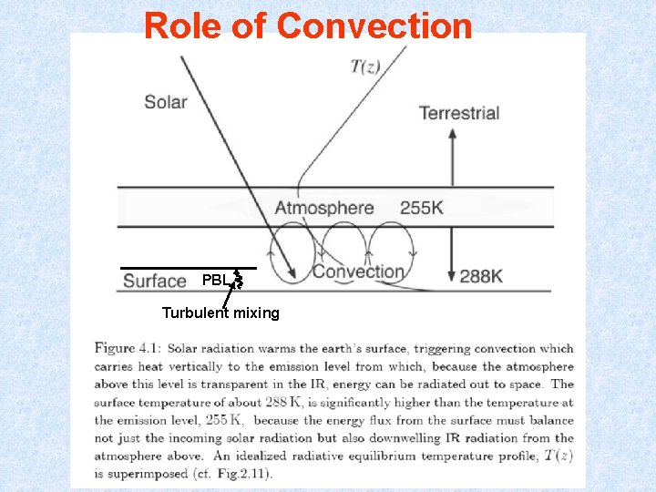
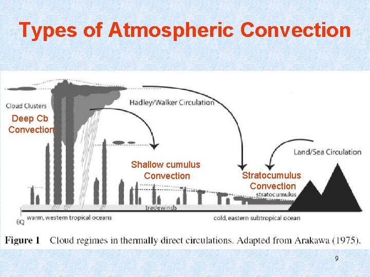
Atmospheric Convection • Atmospheric convection refers to the upward motion that often occurs in an unstable column of the atmosphere. It can happen on a few km scale in cumulus convection to hundreds of km in frontal systems and squall lines. Note: disturbance in a stable layer often leads to gravity waves, not convection. • Classification: - Dry convection with no condensation Moist convection with condensation (to form clouds and sometimes precipitation) Shallow convection: often in the lower troposphere, form stratus clouds, little precipitation. Such as that over marine stratus-cloud regions Deep convection: through the whole troposphere, produces thick cumulus clouds and precipitation. Such as that in the ITCZ. • • Major Roles: - Tropical convection transports moisture and energy upward, which is crucial for the global energy and water balance. Produce most of the precipitation and clouds in the tropics and warm-season mid-latitudes.
Role of Convection PBL Turbulent mixing
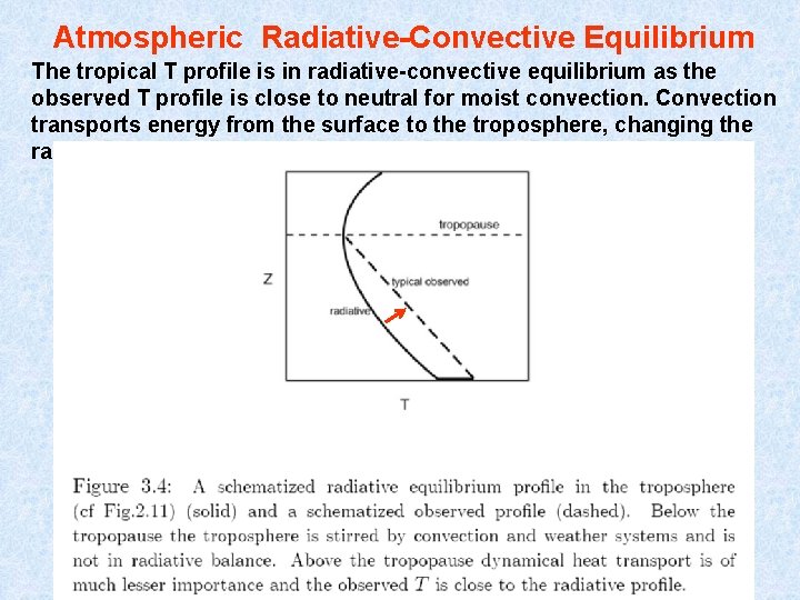
Atmospheric Radiative-Convective Equilibrium The tropical T profile is in radiative-convective equilibrium as the observed T profile is close to neutral for moist convection. Convection transports energy from the surface to the troposphere, changing the radiative T profile to the moist adiabat.
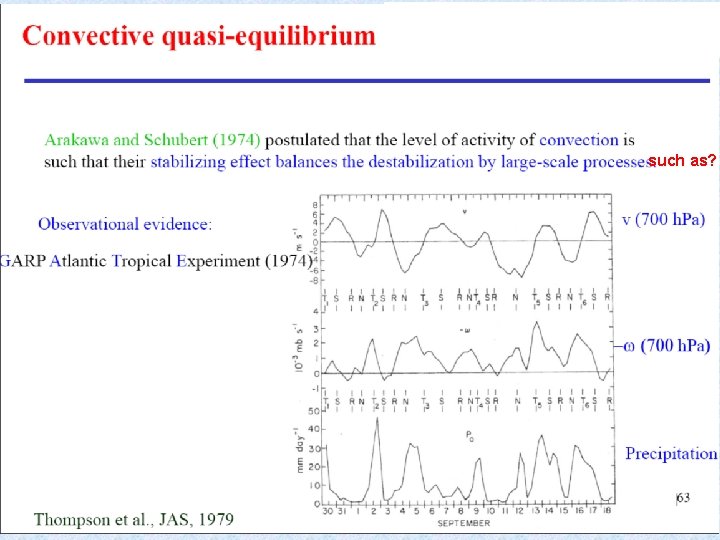
such as? 8
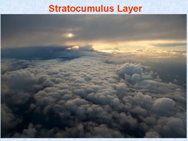
Types of Atmospheric Convection Deep Cb Convection Shallow cumulus Convection Stratocumulus Convection 9
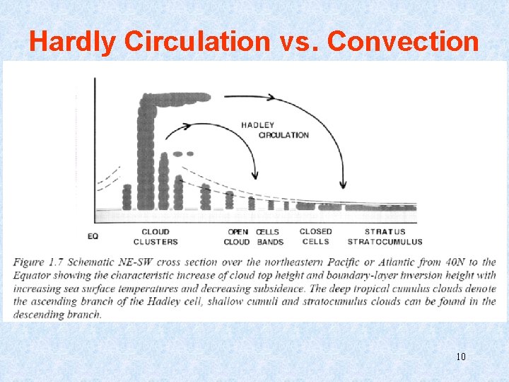
Hardly Circulation vs. Convection 10
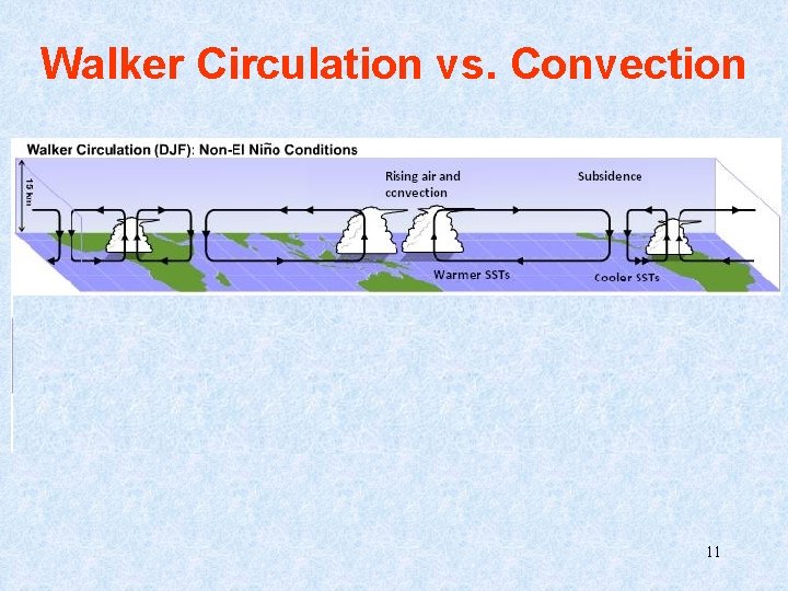
Walker Circulation vs. Convection (Anomaly field) 11
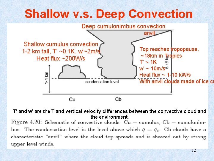
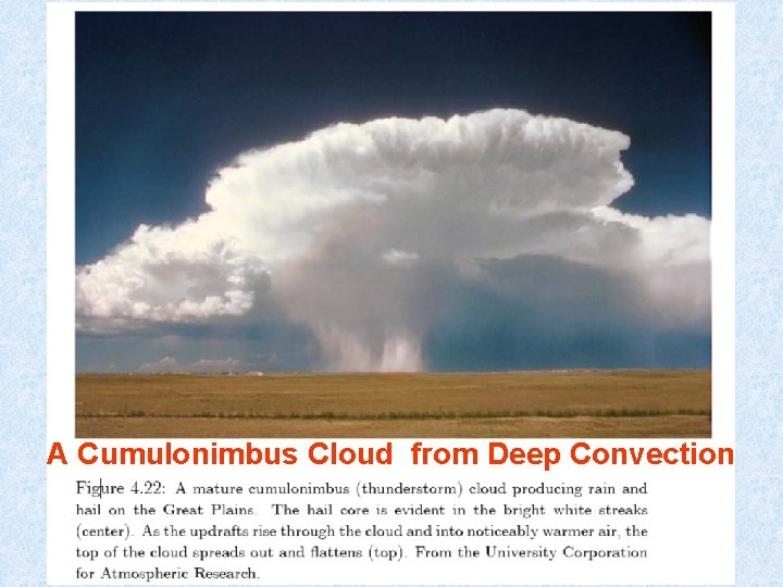
Shallow v. s. Deep Convection Deep cumulonimbus convection anvil Shallow cumulus convection 1 -2 km tall, T’ ~0. 1 K, w’~2 m/s Heat flux ~200 W/s Top reaches tropopause, ~18 km in Tropics T’ ~ 1 K w’ ~ 10 m/s Heat flux ~ 1 -10 k. W/s With anvil clouds made of ice cr T’ and w’ are the T and vertical velocity differences between the convective cloud and the environment. 12
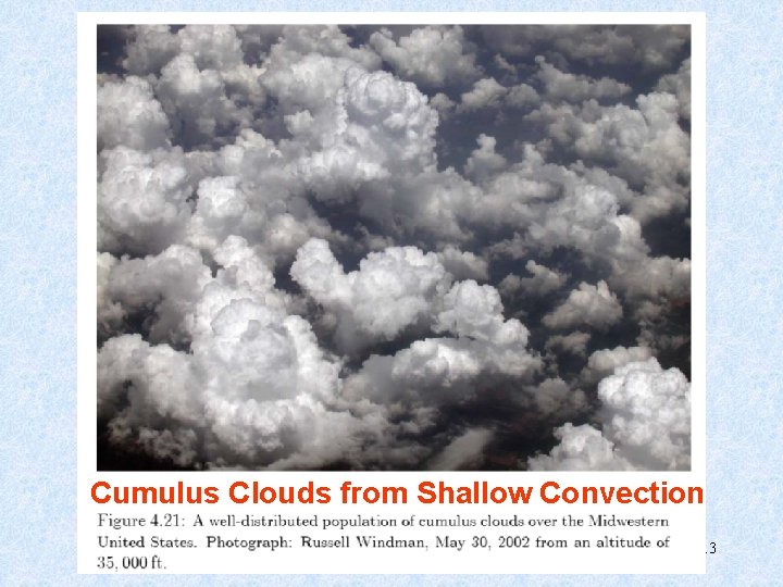
Cumulus Clouds from Shallow Convection 13
Stratocumulus Layer 15
A Cumulonimbus Cloud from Deep Convection 17
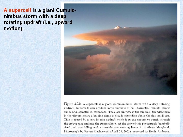
A supercell is a giant Cumulonimbus storm with a deep rotating updraft (i. e. , upward motion). 18
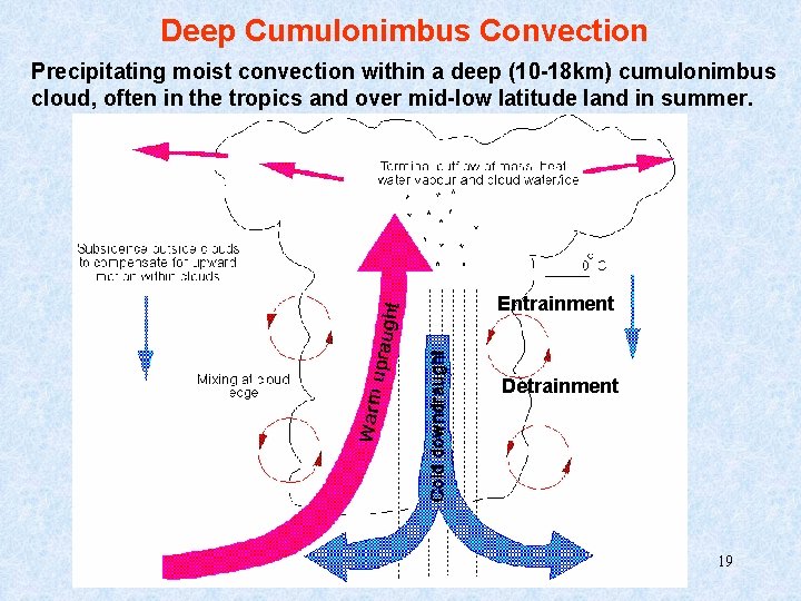
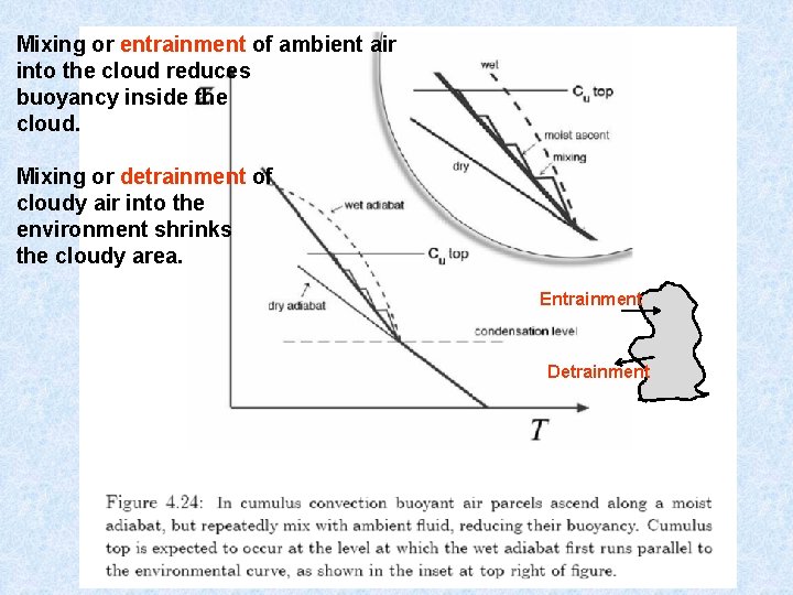
Deep Cumulonimbus Convection Precipitating moist convection within a deep (10 -18 km) cumulonimbus cloud, often in the tropics and over mid-low latitude land in summer. Entrainment Detrainment 19
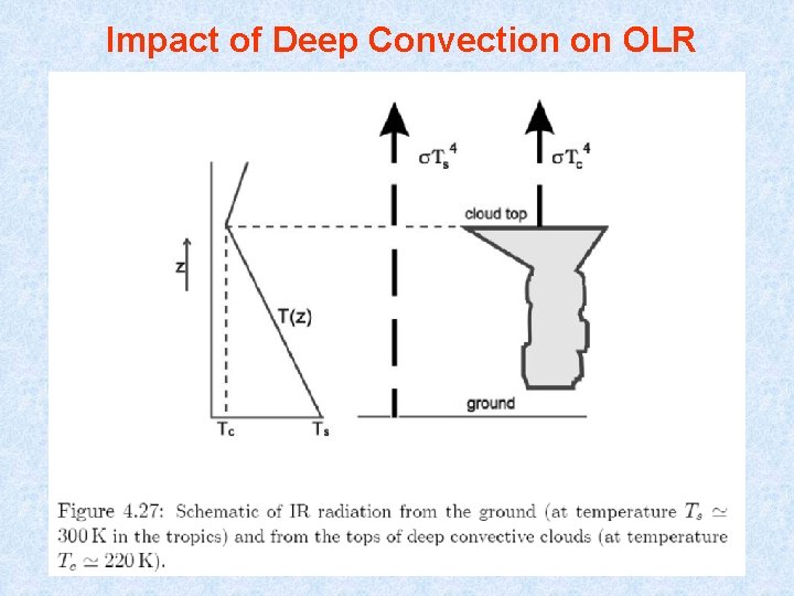
Impact of Deep Convection on OLR
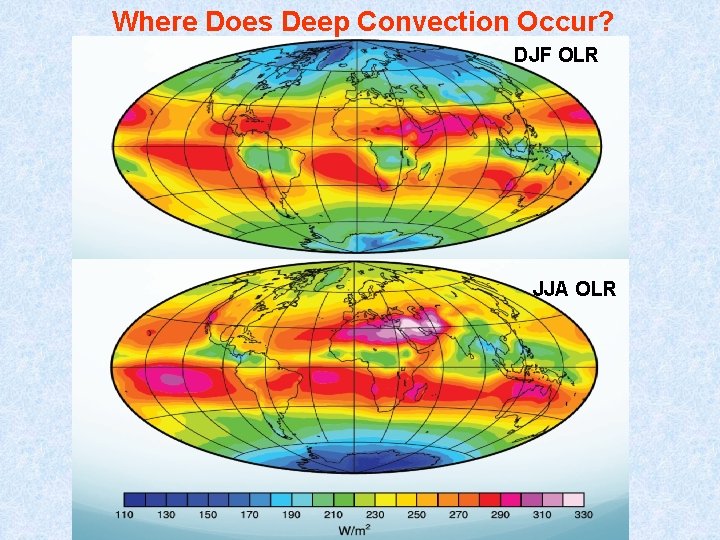
Where Does Deep Convection Occur? DJF OLR JJA OLR
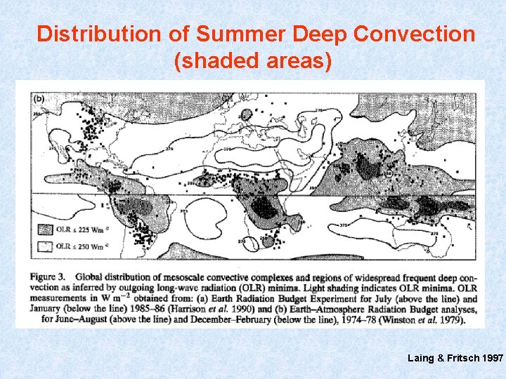
Distribution of Summer Deep Convection (shaded areas) Laing & Fritsch 1997
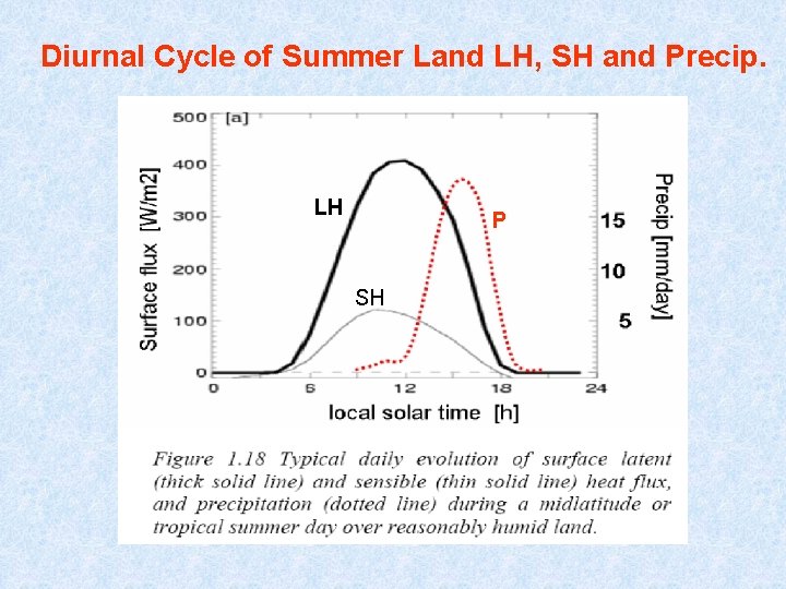
Diurnal Cycle of Summer Land LH, SH and Precip. LH P SH
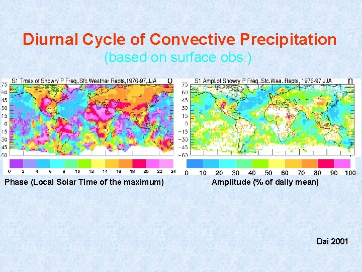
Diurnal Cycle of Convective Precipitation (based on surface obs. ) Phase (Local Solar Time of the maximum) Amplitude (% of daily mean) Dai 2001
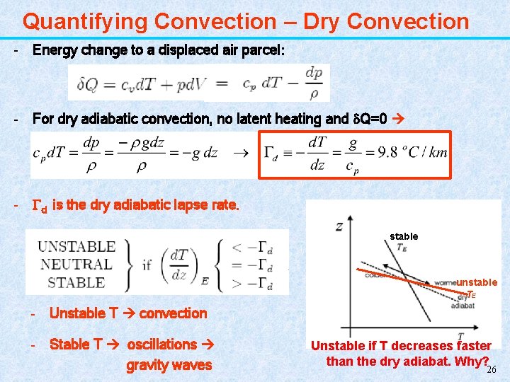
Quantifying Convection – Dry Convection - Energy change to a displaced air parcel: - For dry adiabatic convection, no latent heating and Q=0 - d is the dry adiabatic lapse rate. stable unstable TE - Unstable T convection - Stable T oscillations gravity waves Unstable if T decreases faster than the dry adiabat. Why? 26
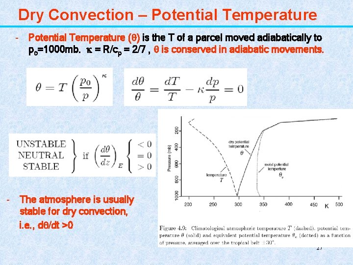
Dry Convection – Potential Temperature - Potential Temperature ( ) is the T of a parcel moved adiabatically to po=1000 mb. = R/cp = 2/7 , is conserved in adiabatic movements. - The atmosphere is usually stable for dry convection, i. e. , d /dt >0 27
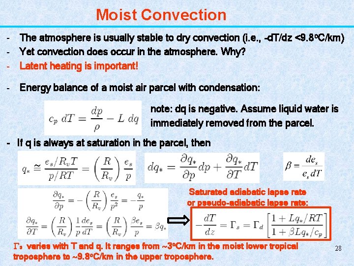
Moist Convection - The atmosphere is usually stable to dry convection (i. e. , -d. T/dz <9. 8 o. C/km) - Yet convection does occur in the atmosphere. Why? - Latent heating is important! - Energy balance of a moist air parcel with condensation: note: dq is negative. Assume liquid water is immediately removed from the parcel. - If q is always at saturation in the parcel, then Saturated adiabatic lapse rate or pseudo-adiabatic lapse rate: s varies with T and q. It ranges from 3 o. C/km in the moist lower tropical troposphere to 9. 8 o. C/km in the upper troposphere. 28
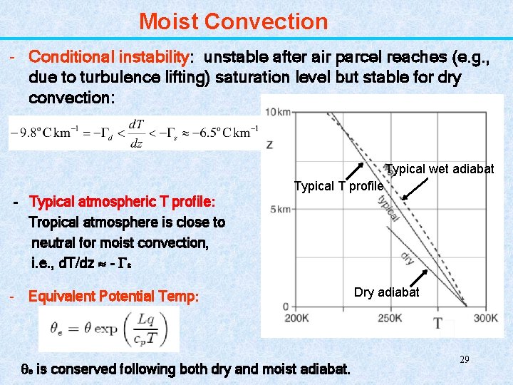
Moist Convection - Conditional instability: unstable after air parcel reaches (e. g. , due to turbulence lifting) saturation level but stable for dry convection: Typical wet adiabat Typical T profile - Typical atmospheric T profile: Tropical atmosphere is close to neutral for moist convection, i. e. , d. T/dz - s - Equivalent Potential Temp: e is conserved following both dry and moist adiabat. Dry adiabat 29
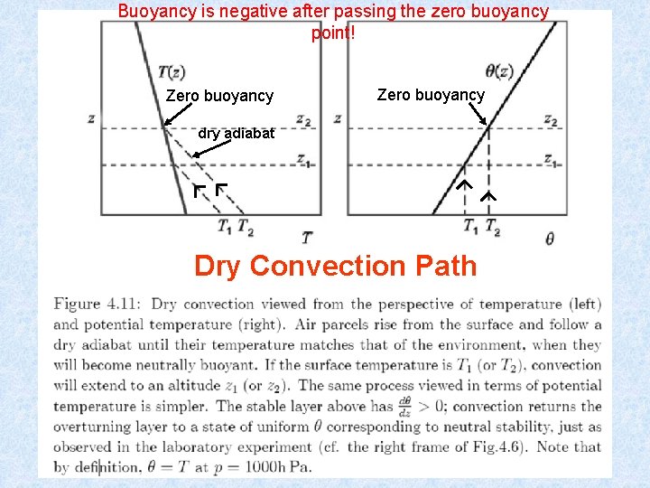
Buoyancy is negative after passing the zero buoyancy point! Zero buoyancy dry adiabat Dry Convection Path 30
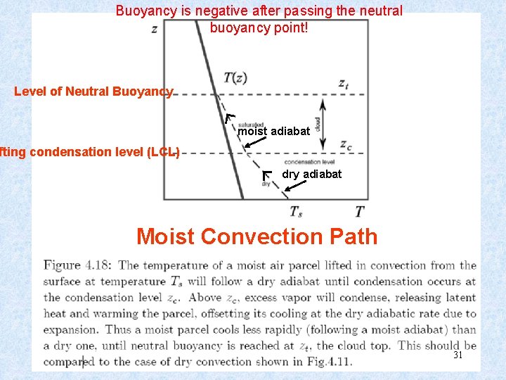
Buoyancy is negative after passing the neutral buoyancy point! Level of Neutral Buoyancy moist adiabat fting condensation level (LCL) dry adiabat Moist Convection Path 31
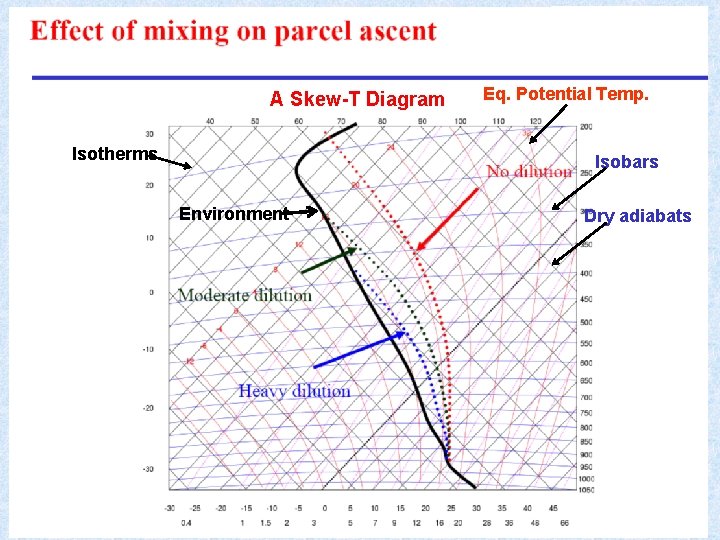
Mixing or entrainment of ambient air into the cloud reduces buoyancy inside the cloud. Mixing or detrainment of cloudy air into the environment shrinks the cloudy area. Entrainment Detrainment 33
A Skew-T Diagram Isotherms Eq. Potential Temp. Isobars Environment Dry adiabats 34
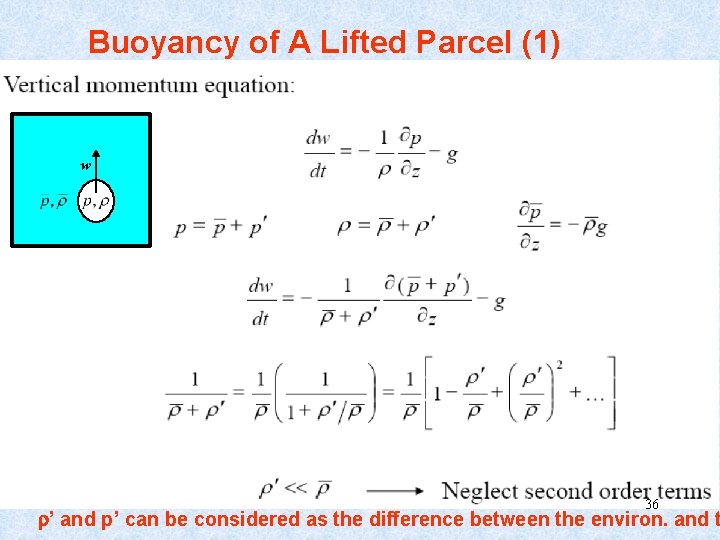
Buoyancy of A Lifted Parcel (1) w 36 ’ and p’ can be considered as the difference between the environ. and t
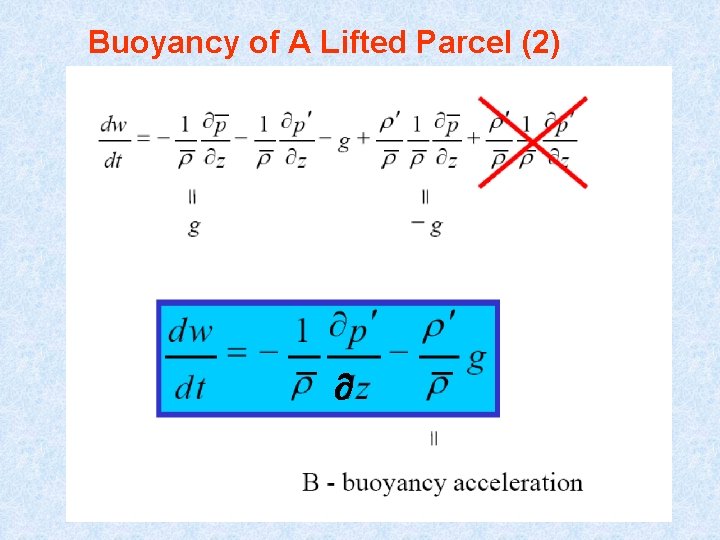
Buoyancy of A Lifted Parcel (2) 37
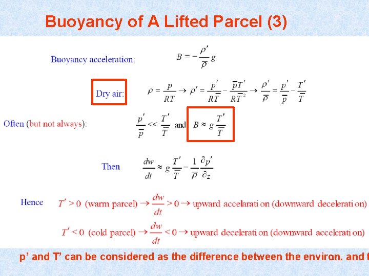
Buoyancy of A Lifted Parcel (3) p’ and T’ can be considered as the difference between the environ. 38 and t
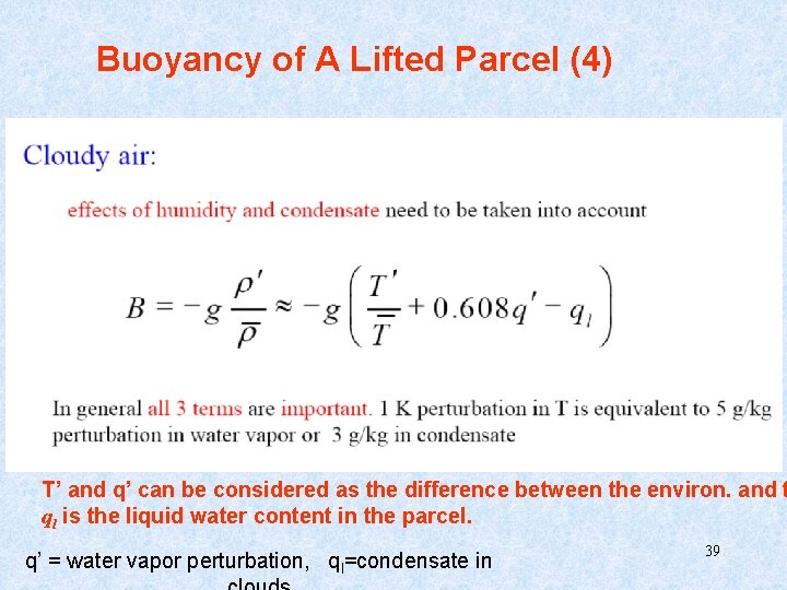
Buoyancy of A Lifted Parcel (4) T’ and q’ can be considered as the difference between the environ. and t ql is the liquid water content in the parcel. q’ = water vapor perturbation, ql=condensate in 39
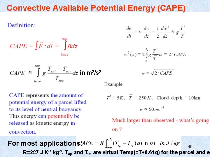
Convective Available Potential Energy (CAPE) in m 2/s 2 For most applications: 40 R=287 J K-1 kg-1, Tvp and Tve are virtual Temp(=T+0. 61 q) for the parcel and en
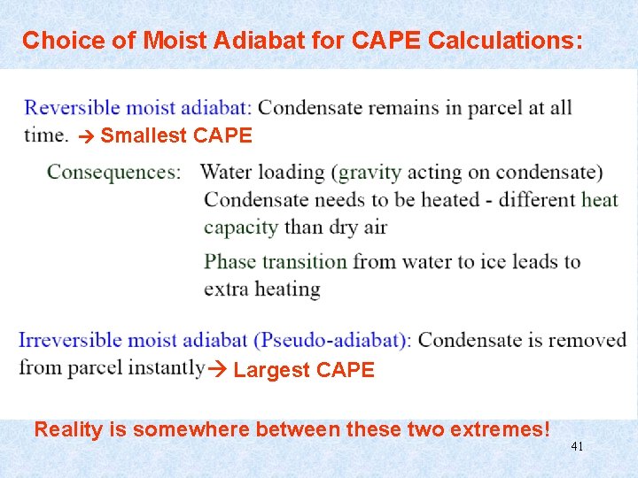
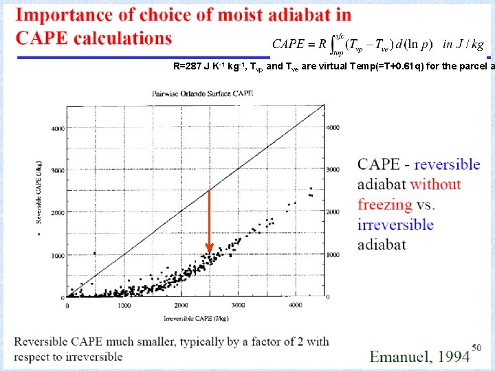
Choice of Moist Adiabat for CAPE Calculations: Smallest CAPE Largest CAPE Reality is somewhere between these two extremes! 41
R=287 J K-1 kg-1, Tvp and Tve are virtual Temp(=T+0. 61 q) for the parcel a 42
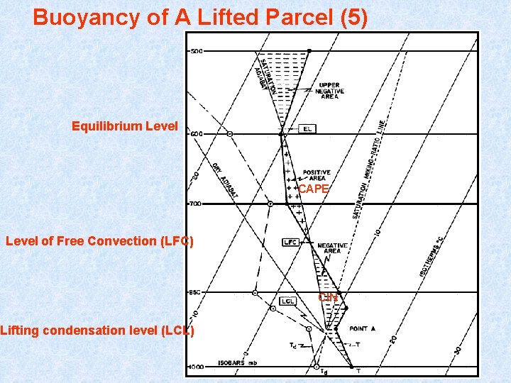
Buoyancy of A Lifted Parcel (5) Equilibrium Level CAPE Level of Free Convection (LFC) CIN Lifting condensation level (LCL) 43
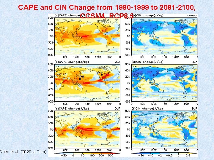
CAPE and CIN Change from 1980 -1999 to 2081 -2100, CCSM 4, RCP 8. 5 Chen et al. (2020, J. Clim) 44
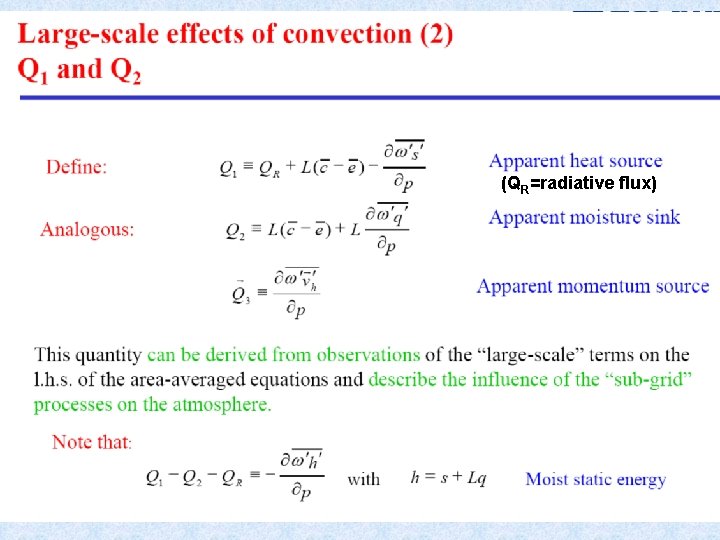
(QR=radiative flux) 46
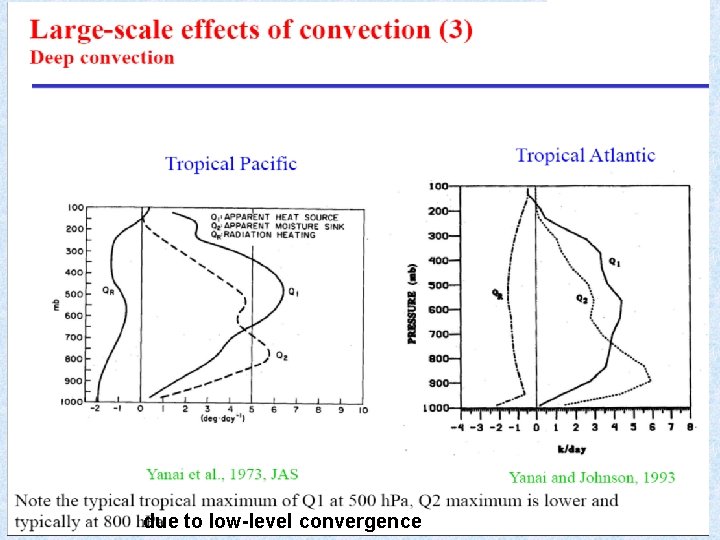
due to low-level convergence 48
Summary • Convection occurs due to enhanced solar heating near the surface, which increases atmospheric instability (i. e. , making T increases faster downward than a stable atmosphere). • It transports energy and moisture from the boundary layer to the middle and upper troposphere, where LW radiation can escape to space. This leads to a radiative-convective equilibrium in the tropics. • Convection affects the atmosphere through condensation, evaporation and vertical eddy transports of energy, moisture, and momentum. • The Q 1 (heating), Q 2 (moisture sink), and Q 3 (momentum transport) fluxes quantify the impacts of convection (sub-grid scale) on the environment (resolved scale in a GCM). • On a large scale, the stabilizing effect of convection balances the destablizing effect of solar heating and other large-scale forcing. • The mean state of the atmosphere is close to the moist adiabat (i. e. , neutral for moist convection); but locally and at times, conditional instability (i. e. , positive buoyancy above LCL) exists in the tropics and warm-season mid-latitudes. • CAPE represents the potential energy available for convection between the Level of Free Convection and Level of Neutral Buoyancy. • Below LFC, there is often some negative buoyancy (convective inhibition or CIN) for a parcel to overcome (e. g. , by turbulence lifting). • There are three common types of convection: shallow cumulus, shallow stratocumulus, and deep cumulonimbus convection. Shallow cumulus convection is most common over the oceans and warm-season land.
After class Assignments: - Reading Assignments: MIT textbook by Marshall and Plumb, chapter 4 (http: //paoc. mit. edu/labweb/notes/chap 4. pdf) Stevens, B. , 2005: Atmospheric Moist Convection. Annu. Rev. Earth Planet. Sci. 2005. 33: 605– 43 Bechtold, P. , 2009: Atmospheric Moist Convection. ECMWF Lecture. (Both are available at the course website under “Other. Reading. Materials”) - Review my ppt slides - Think about following questions (not a homework assignment): 1. 2. Briefly describe the major types of convection in the atmosphere. (20%) Define following: (a) dry lapse rate; (b) moist lapse rate; (c) potential temperature; and (d) CAPE. (30%) 3. What are the major effects of atmospheric convection on the mean state of the atmosphere? (20%) 4. Assume the atmosphere is in hydrostatic balance and isothermal with a temperature of 280 K (i. e. , T=280 K everywhere). Determine the potential temperature at altitudes of 5 km, 10 km, and 20 km above the surface. If an air parcel were moved adiabatically from 10 km to 5 km, what would its temperature be on arrival? (30%)
Next Lecture: Air-Sea and Land-Air Interactions