Study of Topographic Map What is a map


- Slides: 26
Study of Topographic Map
What is a map. � Surface of earth is made up of large number of features such as mountains, plains, rivers, lakes, oceans, etc. � These features are represented by specific symbols, signs and colors. � So Map belongs to diagrammatic representation of natural and physical features of particular area.
Map… �Depending on requirement maps are drawn on small or large scale. �They can be of various types. E. g. Political map, Railways map, Road map etc.
Topography � Topography land. is the physical and natural features of the
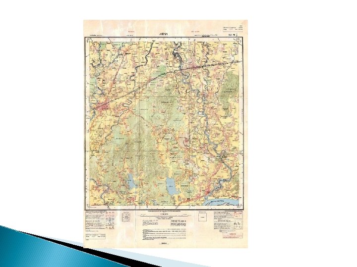
Topographic Map �Maps which represent a symbolic or conventional picture of the physical and cultural landscape of small area on very large scale are known as Topographical maps or Toposheets.
Topographic sheets �Topographic sheet' contain information about an area like roads, railways, settlements, canals, rivers, electric poles, contours/levels and important land marks etc. � According to their usage, they are available at different scales (e. g. 1: 250000, 1: 50000 and 1: 25000 etc, where the former is a small scale as compared to the latter).
INFORMATION ON TOPOGRAPHICAL MAPS • Name of State and District • Location in terms of latitude and Longitude • Scale • Magnetic declination • Conventional signs • Date of issue and revision of toposheet. • Type of landforms such as general slope, hills, valleys etc. • Drainage – Important rivers and tributaries , drainage pattern • Vegetation – Type of forest and type of trees and their distribution.
nt • Forest location and area covered • Wild life sanctuaries and area covered • Land Use cultivated land, waste land other uses • Means of irrigation – Canal, wells and tanks etc • Telephone lines, Transmission lines, airport, seaport etc. • pattern
Significance of toposheet • • A student of geography studies physical and cultural landscape of area. A traveler or a tourist tries to find out locations and plans his tour accordingly. • A planner/ engineer studies natural and cultural resources planning for development project. • defense or aggression. • Geological research. . before
Who Prepares these toposheet • Topographic maps or topo sheets can be procured from Survey of India office Hathi Badkala Estate Dehradun. Contact No 0135 -2747051 -56 • Topographic maps are also available at Regional offices of Survey of India located in different states. • There are two categories of toposheets a. Restricted topo sheets : Covering border area or other sensitive area can be procured with the approval from respective ministry. b. Unrestricted topo sheets : These sheets can be procured directly from available source.
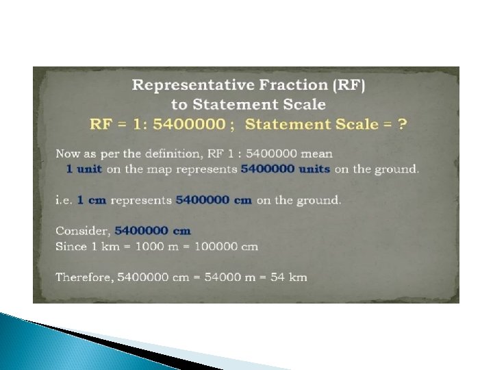
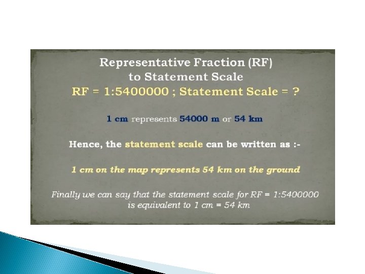
What is Scale �The scale is the ratio of the distance between two points on a map and their real distance on the field. �A scale of 1 in 5000 (1: 5000) means that 1 cm measured on the map corresponds to 5000 cm (or converted into meters, 50 m) on the field.
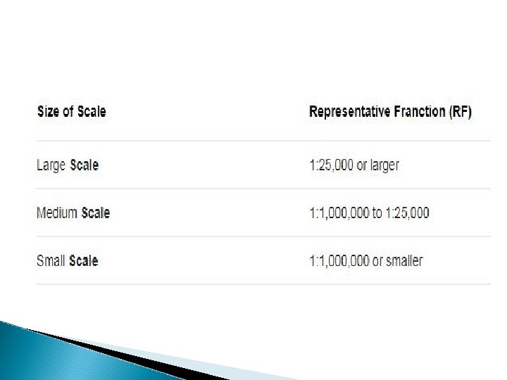
Type of Scale � 1. Statement Scale � 2. Graphical Scale � 3. Representative Fraction
Elevation Measurement �The distinctive characteristic of a topographic map is the use of elevation contour lines to show the shape of the Earth's surface.
Countour Lines � The squiggly lines on a topographic map are called contour lines � Contour lines are lines that represent a certain height or elevation � All points on a contour lines are the same elevation � The arrangement of the contour lines on a map gives a direct indication of the changes in the field's topography.
Contour lines can never cross one another.
Contour Lines and Elevation �The closer the contour lines are to each other, the steeper the slope is. �In hilly areas, the contour lines are close together while they are wider apart on flat slopes.
�On a hill, the contour lines form circles; whereby the values of their elevation increase from the edge to the centre. �In a depression, the contour lines also form circles; the values of their elevation, however, decrease from the edge to the centre.
Identification of Important Features � 1. Mountain - high elevation � 2. Depression - low elevation
Topographic Symbols �Mappers, also called cartographers use symbols to represent certain things on a topographic map �For example, the color green represents an area with lots of trees or vegetation �Red is used to show a road, highway or interstate �Buildings are usually shown as little black squares
Difference of Topographic and Geological Map. � 1. Topographic maps are three-dimensional representations of landmass that use contour lines to depict elevation. � 2. Geologic maps are special purpose maps that show the geological properties of land – rock types, rock age, bedding planes, folds, and faults.