Steps for Reporting a Mark Recovery Preparing Your


")


 at Natural Bridge Virginia")


 Beartooth Highway Summit Elev. 10, 947 ft PX 0413 Mark Elev.")


 also part of the National Spatial")


- Slides: 36
Steps for Reporting a Mark Recovery Preparing Your Pictures for a Mark Recovery Report Note: Each picture used in a recovery report must have the PID in the filename! Steps if you use a Smart Phone Camera with recommended Solocator* App to take pictures of the marks found: 1. Make a new folder on your computer with the date of your geo mark recovery outing - example: Geo 06 -12 -17 2. Connect your Smartphone to the computer, and move or copy your mark pictures to that folder 3. Within that folder, add a new folder for each different mark found and name folder with the marks PID number - example EZ 2951 4. Move all pictures of a given mark into it’s correct folder 5. In each folder, pick out the best picture of the mark and rename it so that it has the mark’s PID in the filename, e. g. EZ 2951 Pic
Where do I go to submit a Marker Recovery Report? 1. 2. 3. 4. 5. 6. 7. 8. 9. go to the USPS Homepage at www. usps. org at top of page select Member’s Log In Log in with your Certificate No. and Pin at top of page select Departments from dropdown list select Executive Department from next dropdown list select Cooperative Charting Committee on left of CCC page select Geodetic Program near bottom next page select Reporting – Geodetic Reporting at bottom of next page select Geodetic Report Form 2018
Where do I go to submit a Marker Recovery Report? 1. go to the USPS Homepage at www. usps. org 2. at top of page select Member’s Log In 3. Log in with Certificate No. and Pin
4. at top of page select Departments 5. from dropdown list select Executive Department 6. from next dropdown list select Cooperative Charting Committee
7. on left of Coop Charting Committee page select Geodetic Program
8. near bottom page select Reporting -- Geodetic Reporting
9. at bottom of Geodetic Reporting page select Geodetic Report Form 2017 Report Year is Jan 1 – Dec 31 You have 30 days from date of a mark recover to submit a report!
Marker Submittal Report First Page
Marker Submittal Report Second Page 1 st Mark Enter the mark’s PID and the Type of Mark
Horizontal or Vertical in Submission Report? In National Geodetic Survey Data Explorer: If the mark symbol on the map has “Vertical Control” in the Control Types description, the mark should be reported VERTICAL …. . even if the stamping on the disk is HORIZONTAL. All other mark symbols should be reported HORIZONTAL. Not Reported H V H V H
Horizontal or Vertical in Submission Report? The prior guideline for USPS determination of Horizontal or Vertical Control based on NGS Data Explorer symbol descriptions is: • • Consistent with NGS criteria Easy to use without ambiguity Does not require data sheet interpretation Gives the correct USPS submission report designation for nearly all marks found However, the USPS Cooperative Charting Committee provides an additional guideline that can be more liberal for credits in some instances: If the NGS datasheet says “Adjusted” anywhere in vertical data, the mark can and should be designated VERTICAL in the submission report.
Marker Submittal Report Enter the mark’s “Previous” Date of Recovery and Condition From Data Sheet
Marker Submittal Report Enter the mark’s “Current” Condition and enter brief Recovery Notes
Marker Submittal Report Upload the Photos • Make sure they have the PID in the filename • One photo should be a closeup with date and coordinates • Others photos if included are supplementary Can enter up to 5 Marks per Report
Marker Submittal Report Submission Page Last Page (Page 7)
Marker Submittal Report Keep a data record of your submission and Report No. Submission was Successful with Repot No.
BUTTERMILK – The Oldest Surviving Survey Mark This bronze plaque commemorates BUTTERMILK, the oldest surviving first-order (high accuracy) triangulation station survey point (mark) in the United States. It was dedicated in 1776 as part of the U. S. Bicentennial Celebration. Located just north of NY City.
Original mark set in 1833 by Ferdinand Hassler a drill hole 2. 5” in diameter and 10” deep Bronze disc mark later set by National Geodetic Survey in 1932
Some Memorable Mark Recoveries 100 th Anniversary of First Flight – PID DK 3532 (Designation: POND) Location: Town of Kitty Hawk
PID GW 2116 (Designation: GW 1750) at Natural Bridge Virginia
Lin eo fs igh Standing at the Mark’s location, looking across the creek you can see George Washington’s initials carved in stone t
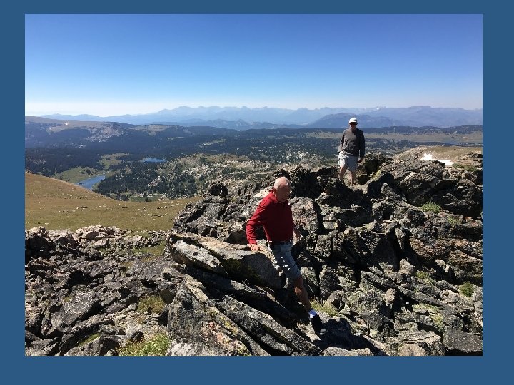
Highest Mark Personally Found – in Wyoming Beartooth Highway switchbacks to Summit in Wyoming
Beartooth–Absaroka Wilderness (Montana/Wyoming) Beartooth Highway Summit Elev. 10, 947 ft PX 0413 Mark Elev. 11062 ft
Photographing the “Stockaid” Marker
PID PX 0413 Designation: STOCKAID WY – 11, 000+ ft Elevation
Oldest Mark Personally Found – 1918, near former Seaboard Airline Railroad, Youngsville FY 0211 and FY 0212 – Youngsville, NC
Reference Mark Found – 1918, at Old Apex Rail Station – Now Apex Chamber of Commerce EZ 0599 – Apex, NC Note: No USPS Credit given for a “Reference Mark”
Train Caboose at the Apex Chamber of Commerce
Modernization: GPS is used to improve location accuracy of marks Mark GPS Augmentation Pictures from NOAA Video Library
Presentation: “Onward to 2022: Replacing the North American Datum 1983 & North American Vertical Datum 1988”, William Stone Southwest Region (AZ, NM, UT) Geodetic Advisor
Presentation: “Onward to 2022: Replacing the North American Datum 1983 & North American Vertical Datum 1988”, William Stone Southwest Region (AZ, NM, UT) Geodetic Advisor
Mark Modernization: GPS “Continuously Operating Reference Stations” (CORS) also part of the National Spatial Reference System Approx. 2000 CORS Stations established in 2015 and growing DL 3891 GPS CORS, Jordan Lake, Forest Service Headquarters
Horizontal Datum NAHD 83 and Vertical Datum NAVD 88 will be replaced with a “New Datum” (target date 2022) based primarily on Global Navigation Satellite Systems e. g. GPS Will Passive Monuments (Disk and Rod Marks) still be important?
Yes – geodetic markers and their recovery will continue to be important going forward: • In NC - reference to a horizontal control mark is required for boundary surveys • In NC - reference to a vertical benchmark is required for elevation surveys • Marks will be used with CORS (GPS) as part of the 2022 horizontal / vertical datum • Marks will be used for quality control of CORS data • Marks will be used to perform geodetic leveling • Marks will be used for gravity observations • Marks will play a “critical role” in support of the development of the 2022 datum and to support users of the 2022 datum The above information is per communication with Gary Thompson, North Carolina Geodetic Survey Chief, on 07 -12 -17
The End!