State Climate Office Weekly Drought Update Adnan Akyuz

- Slides: 26

State Climate Office Weekly Drought Update Adnan Akyuz, Ph. D. NDSU, AES State Climatologist Last Update: 7/9/2020

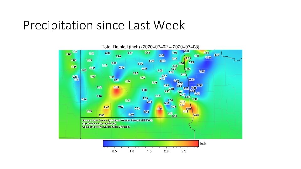
Precipitation since Last Week

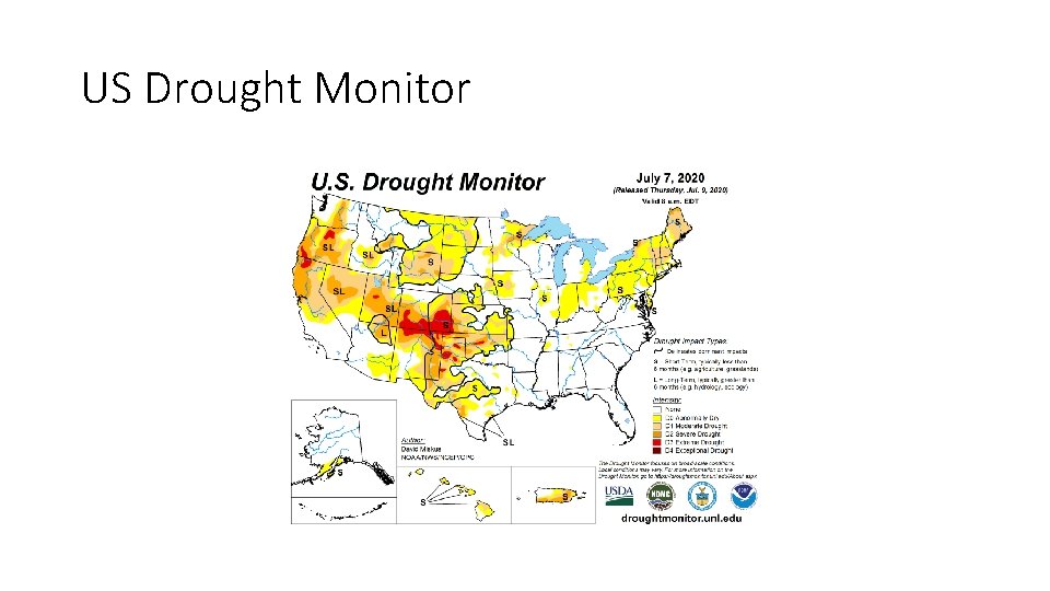
US Drought Monitor

State-wide Precipitation Rankings June 2020 (ND: 30 th Driest) April-June 2020 (ND: 9 th Driest) NOAA National Centers for Environmental information, Climate at a Glance: Divisional Mapping from https: //www. ncdc. noaa. gov/cag/

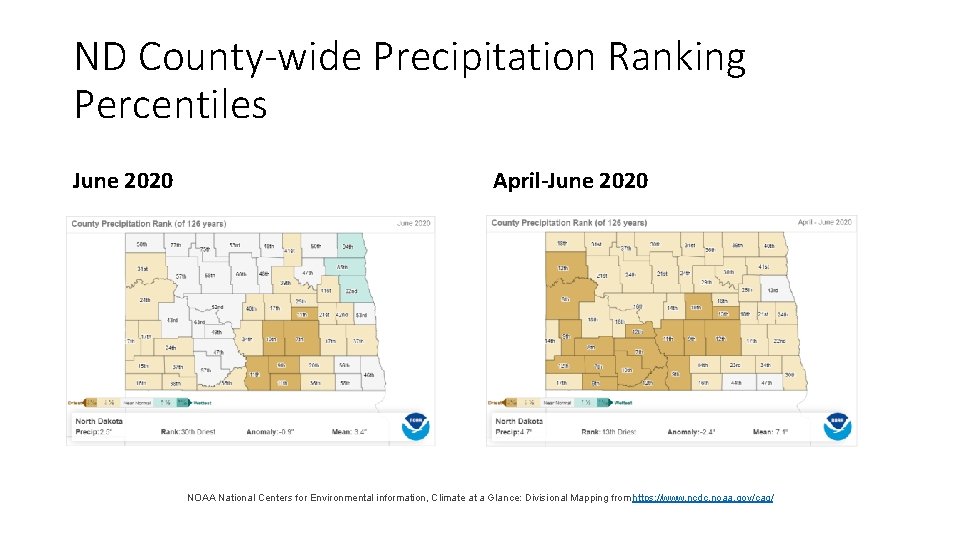
ND County-wide Precipitation Ranking Percentiles June 2020 April-June 2020 NOAA National Centers for Environmental information, Climate at a Glance: Divisional Mapping from https: //www. ncdc. noaa. gov/cag/

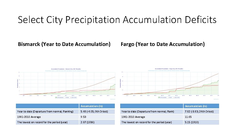
Select City Precipitation Accumulation Deficits Bismarck (Year to Date Accumulation) Fargo (Year to Date Accumulation) Accumulation (in) Year to date (Departure from normal; Ranking) 5. 48 (-4. 05; 9 th Driest) Year to date (Departure from normal; Rank) 7. 82 (-3. 83; 24 th Driest) 1981 -2010 Average 9. 53 1981 -2010 Average 11. 65 The lowest on record for the period (year) 2. 87 (1936) The lowest on record for the period (year) 5. 15 (1910)

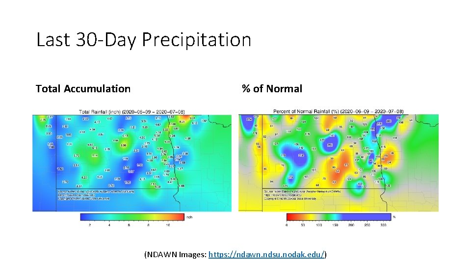
Last 30 -Day Precipitation Total Accumulation % of Normal (NDAWN Images: https: //ndawn. ndsu. nodak. edu/)

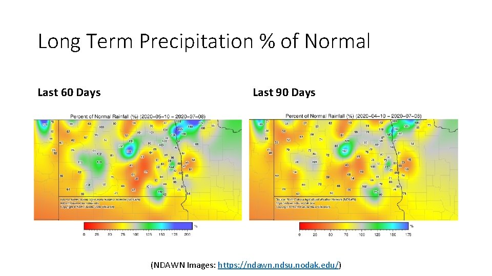
Long Term Precipitation % of Normal Last 60 Days Last 90 Days (NDAWN Images: https: //ndawn. ndsu. nodak. edu/)

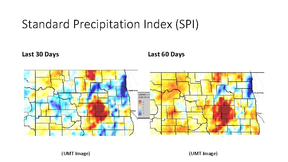
Standard Precipitation Index (SPI) Last 30 Days Last 60 Days (UMT Image)

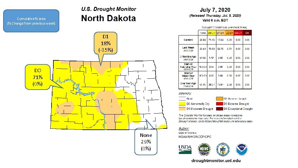
Cumulative % area (% Change from previous week) D 1 18% (-35%) DO 71% (0%) None 29% (0%)

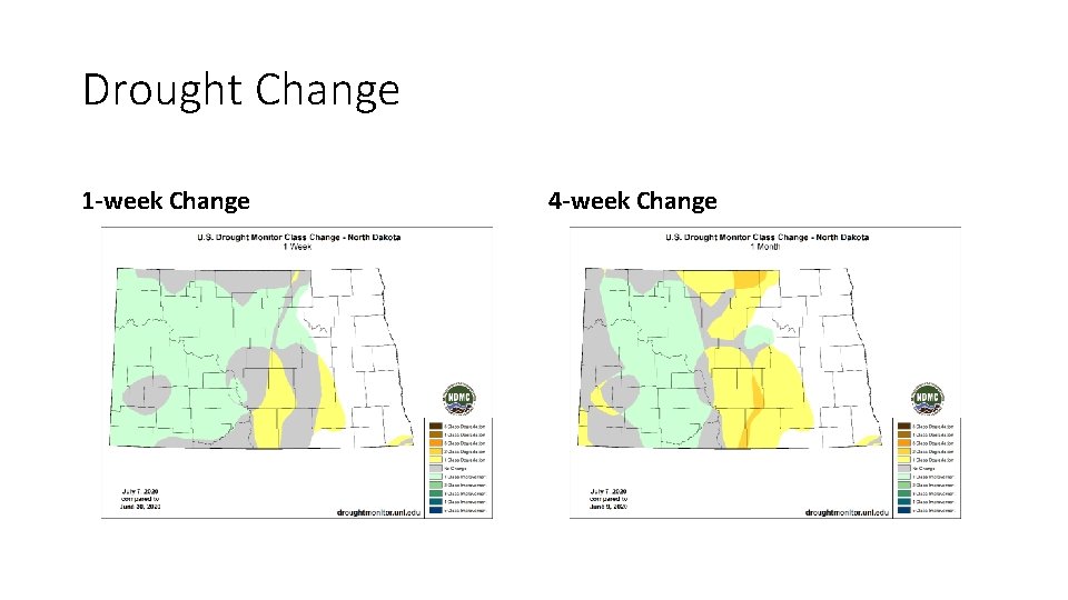
Drought Change 1 -week Change 4 -week Change

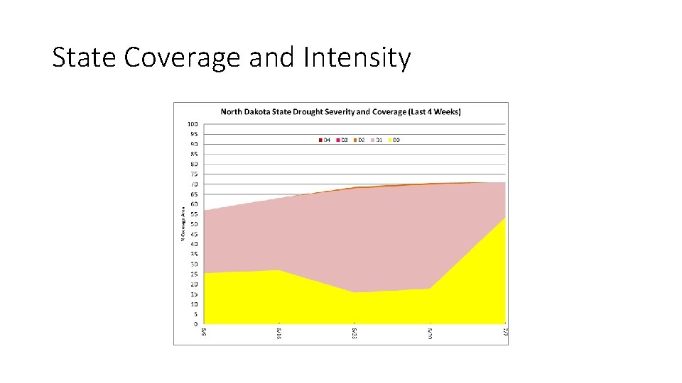
State Coverage and Intensity

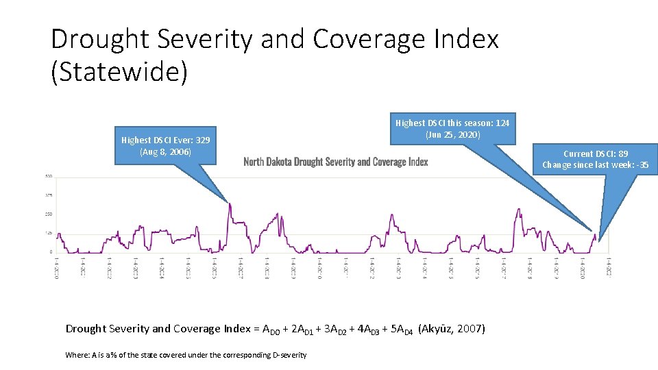
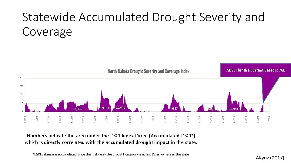
Drought Severity and Coverage Index (Statewide) Highest DSCI Ever: 329 (Aug 8, 2006) Highest DSCI this season: 124 (Jun 25, 2020) Drought Severity and Coverage Index = ADO + 2 AD 1 + 3 AD 2 + 4 AD 3 + 5 AD 4 (Akyüz, 2007) Where: A is a % of the state covered under the corresponding D-severity Current DSCI: 89 Change since last week: -35

Statewide Accumulated Drought Severity and Coverage ADSCI for the Current Season: 760 19, 319 9, 530 10, 642 9653 2116 11, 991 1714 Numbers indicate the area under the DSCI Index Curve (Accumulated DSCI*) which is directly correlated with the accumulated drought impact in the state. *DSCI values are accumulated since the first week the drought category is at last D 1 anywhere in the state. Akyuz (2017)

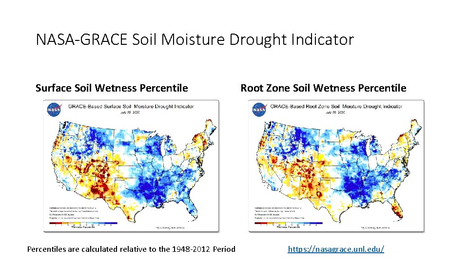
NASA-GRACE Soil Moisture Drought Indicator Surface Soil Wetness Percentiles are calculated relative to the 1948 -2012 Period Root Zone Soil Wetness Percentile https: //nasagrace. unl. edu/

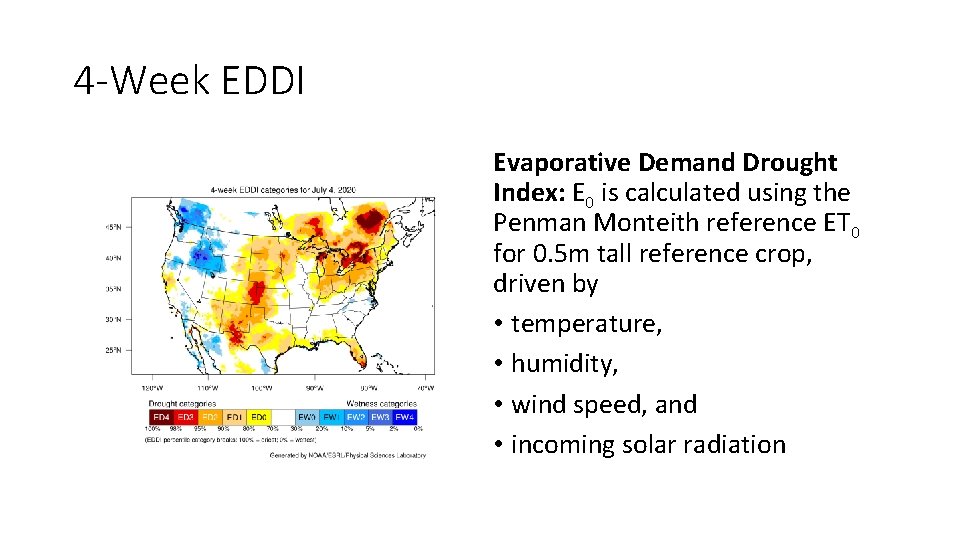
4 -Week EDDI Evaporative Demand Drought Index: E 0 is calculated using the Penman Monteith reference ET 0 for 0. 5 m tall reference crop, driven by • temperature, • humidity, • wind speed, and • incoming solar radiation

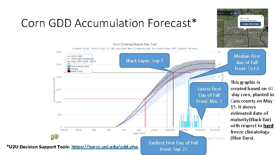
Corn GDD Accumulation Forecast* Median First day of Fall Frost: Oct 9 Black Layer: Sep 7 Latest First Day of Fall Frost: Nov 3 *U 2 U Decision Support Tools: https: //hprcc. unl. edu/gdd. php Earliest First Day of Fall Frost: Sep 20 This graphic is created based on 90 -day corn, planted in Cass county on May 15. It shows estimated date of maturity(Black Bar) with respect to hard freeze climatology (Blue Bars).

Weekly Drought Impact Collection Based on the NDSU Weekly Survey of Extension Offices

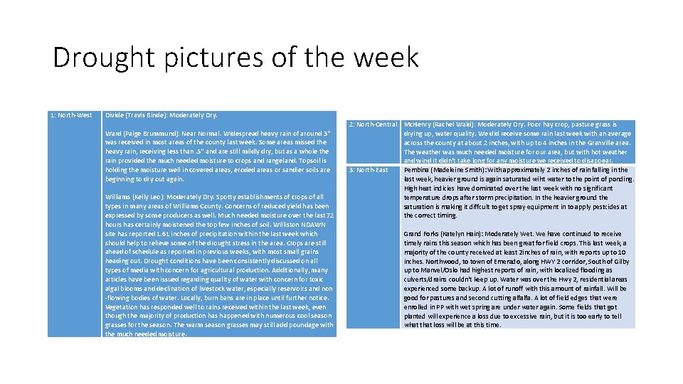
Drought pictures of the week 1: North-West Divide (Travis Binde): Moderately Dry. Ward (Paige Brummund): Near Normal. Widespread heavy rain of around 3" was received in most areas of the county last week. Some areas missed the heavy rain, receiving less than. 5" and are still mildly dry, but as a whole the rain provided the much needed moisture to crops and rangeland. Topsoil is holding the moisture well in covered areas, eroded areas or sandier soils are beginning to dry out again. Williams (Kelly Leo): Moderately Dry. Spotty establishments of crops of all types in many areas of Williams County. Concerns of reduced yield has been expressed by some producers as well. Much needed moisture over the last 72 hours has certainly moistened the top few inches of soil. Williston NDAWN site has reported 1. 61 inches of precipitation within the last week which should help to relieve some of the drought stress in the area. Crops are still ahead of schedule as reported in previous weeks, with most small grains heading out. Drought conditions have been consistently discussed on all types of media with concern for agricultural production. Additionally, many articles have been issued regarding quality of water with concern for toxic algal blooms and declination of livestock water, especially reservoirs and non -flowing bodies of water. Locally, burn bans are in place until further notice. Vegetation has responded well to rains received within the last week, even though the majority of production has happened with numerous cool season grasses for the season. The warm season grasses may still add poundage with the much needed moisture. 2: North-Central Mc. Henry (Rachel Wald): Moderately Dry. Poor hay crop, pasture grass is drying up, water quality. We did receive some rain last week with an average across the county at about 2 inches, with up to 4 inches in the Granville area. The weather was much needed moisture for our area, but with hot weather and wind it didn't take long for any moisture we received to disappear. 3: North-East Pembina (Madeleine Smith): With approximately 2 inches of rain falling in the last week, heavier ground is again saturated wiht water to the point of ponding. High heat indicies have dominated over the last week with no significant temperature drops after storm precipitation. In the heavier ground the saturation is making it diffcult to get spray equipment in to apply pestcides at the correct timing. Grand Forks (Katelyn Hain): Moderately Wet. We have continued to receive timely rains this season which has been great for field crops. This last week, a majority of the county received at least 2 inches of rain, with reports up to 10 inches. Northwood, to town of Emerado, along HWY 2 corridor, South of Gilby up to Manvel/Oslo had highest reports of rain, with localized flooding as culverts/drains couldn't keep up. Water was over the Hwy 2, residential areas experienced some backup. A lot of runoff with this amount of rainfall. Will be good for pastures and second cutting alfalfa. A lot of field edges that were enrolled in PP with wet spring are under water again. Some fields that got planted will experience a loss due to excessive rain, but it is too early to tell what that loss will be at this time.

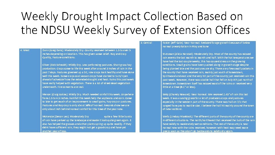
Weekly Drought Impact Collection Based on the NDSU Weekly Survey of Extension Offices 5: Central 4: West Dunn (Greg Benz): Moderately Dry. County received between 1. 5 to over 5 inches depending on location. This has given some relief. Hay and Crop Quality, Pasture conditions. Oliver (Rick Schmidt): Mildly Dry. Low performing pastures. Short grass hay production. Crops came to life this week after around 3 inches of rain in the past 7 days. Pastures greened up a bit, row crops look healthy and have done well this week. Some crops cool season crops have started to turn/ripen ahead of schedule from the extended drought and heat. Rains this past week have really helped with vegetation. There is a lot of dried dead vegetation underneath. Fire concerns are real. Mercer (Craig Askim): Mildly Dry. Much needed rainfall this week. Anywhere from 2. 5 to 4. 5 inches. Rainfall this week help the soybeans and corn. Came to late to get much of an improvement to small gains, hay crop or pastures. Pastures and Hay crop is only about 50% of normal. Records show we are only about inch behind normal rainfall for this time of the year now. Mc. Kenzie (Devan Leo): Moderately Dry quite a few little bursts of rain have perked up the landscape and made it look quite green again. It also has helped the grasses and other plants spring up quite readily. if they didnt have sufficient rain, they might not get a good crop and have yet another year of loss. Foster (Jeff Gale): Near Normal. Reduced forage growth because of below normal preceipitation in May and June Stutsman (Alicia Harstad): Moderately Dry. Most of the county has missed rain events the last month to month and half. With the hot temperatures we have had the last couple weeks, this has caused stress on the growing conditions. Small grains have been pushed along in growth stage despite being planted late and the pastures are dry. There a few small pockets in the county that have received rain, mainly just south of Jamestown, Spiritwood and east and the very NE part of the county just received rain this past week. However, there was sizable hail that fell on July 4 th just north of Jamestown itself has missed most of the rains or received very little at a time (0. 1" or less). Eddy (Chandy Howard): Near Normal. We received 2. 45" of rain this last week. It was a saving grace for a lot of producers crops and pastures especially in the western part of the county. There was hail on 7/1 that ranged from pea to marble size. I believe the hail hit mainly around the town of new rockford. Wells (Lindsay Maddock): The different parts of the county are in different situations. The north/northwest that received the bulk of the rain have mildly to moderately wet conditions. The rest of the county is near normal now with the rains received, however with heat may need more precip soon so they don't go backwards to mildly dry again.

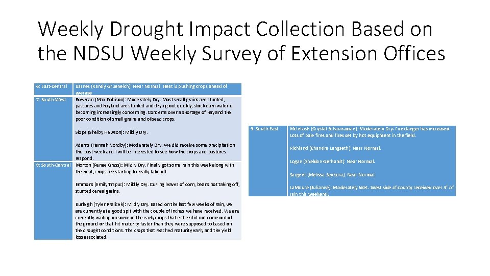
Weekly Drought Impact Collection Based on the NDSU Weekly Survey of Extension Offices 6: East-Central Barnes (Randy Grueneich): Near Normal. Heat is pushing crops ahead of average 7: South-West Bowman (Max Robison): Moderately Dry. Most small grains are stunted, pastures and hayland are stunted and drying out quickly, stock dam water is becoming increasingly concerning. Concerns over a shortage of hay and the poor condition of small grains and oilseed crops. Slope (Shelby Hewson): Mildly Dry. Adams (Hannah Nordby): Moderately Dry. We did receive some precipitation this past week and I will be interested to see how the crops and pastures respond. 8: South-Central Morton (Renae Gress): Mildly Dry. Finally got some rain this week along with the heat, crops are starting to really take off. Emmons (Emily Trzpuc): Mildly Dry. Curling leaves of corn, beans not taking off, stunted cereal grains. Burleigh (Tyler Kralicek): Mildly Dry. Based on the last few weeks of rain, we are currently at a good spit with the couple of inches we have received. We are currently waiting on some of the early crops that either did not come out of the ground or that hit maturity faster than they were supposed to based on the drought conditions. The crops that reached maturity early and the yield loss associated. 9: South-East Mc. Intosh (Crystal Schaunaman): Moderately Dry. Fire danger has increased. Lots of bale fires and fires set by hot equipment in the field. Richland (Chandra Langseth): Near Normal. Logan (Sheldon Gerhardt): Near Normal. Sargent (Melissa Seykora): Near Normal. La. Moure (Julianne): Moderately Wet. West side of county received over 3" of rain this weekend.

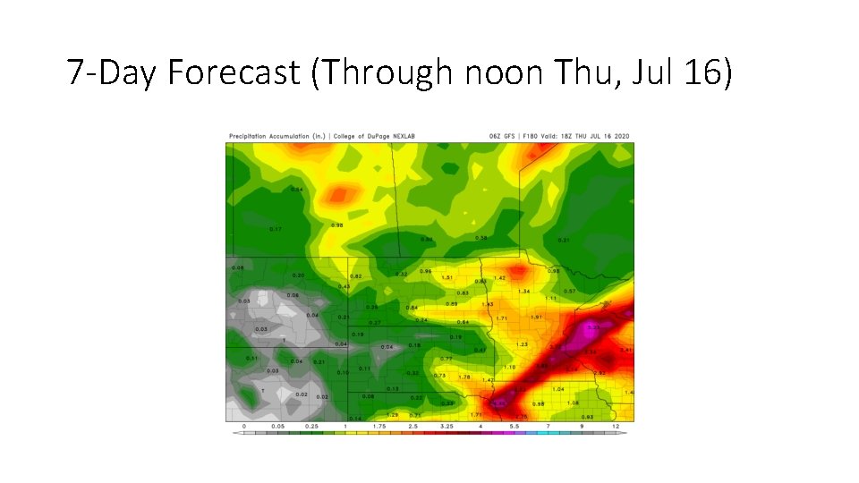
7 -Day Forecast (Through noon Thu, Jul 16)

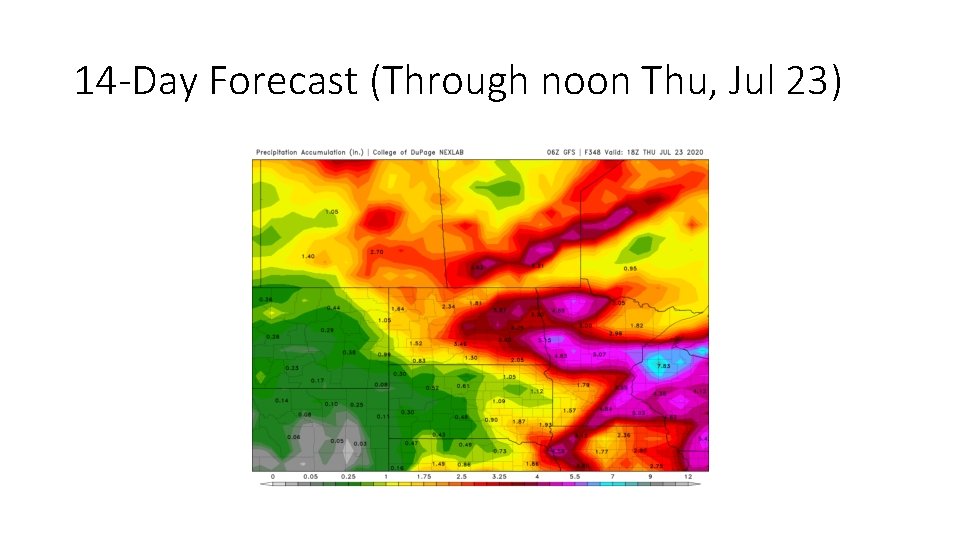
14 -Day Forecast (Through noon Thu, Jul 23)

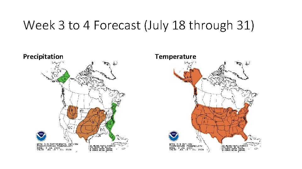
Week 3 to 4 Forecast (July 18 through 31) Precipitation Temperature

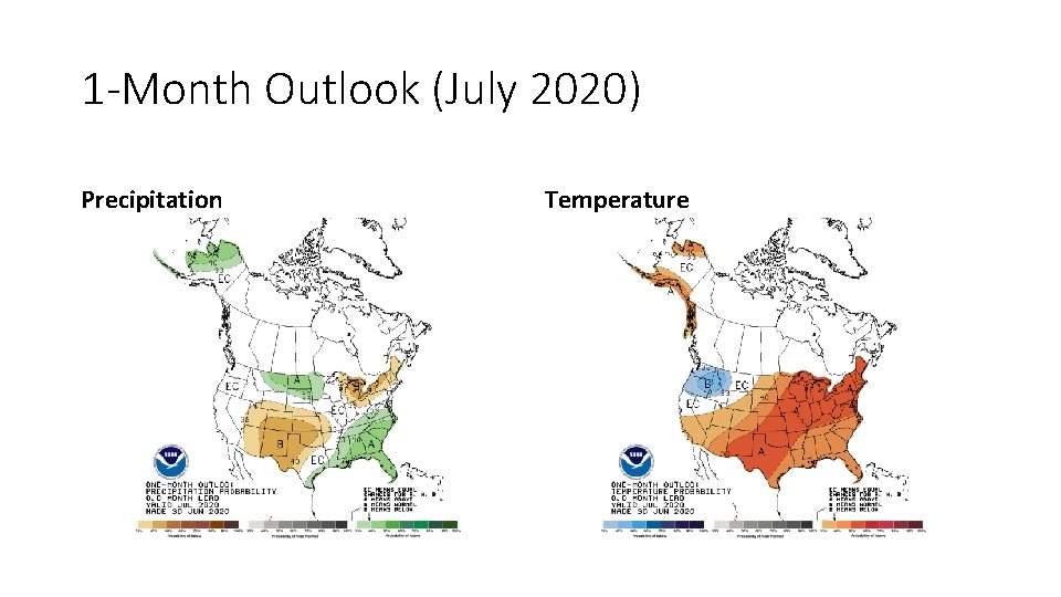
1 -Month Outlook (July 2020) Precipitation Temperature

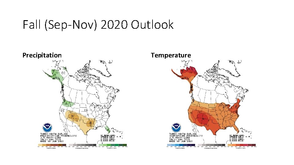
Fall (Sep-Nov) 2020 Outlook Precipitation Temperature