SS 8 G 1 TSW describe Georgia with

SS 8 G 1 TSW describe Georgia with regard to physical features & location. a. Locate Georgia in relation to region, nation, continent, and hemisphere. 1

Georgia’s relative location is in the northern hemisphere, on the continent of North America, in the southeastern corner of the United States. 2

Five states border Georgia: Florida to the south, Alabama to the west, Tennessee and North Carolina to the north, and South Carolina to the northeast. 3

Georgia’s absolute location is between 30° 21’ and 35°E latitude and between 80° 50’ and 80° 36’ W longitude. 4

Georgia: * largest state east of the Mississippi *greatest length = 315 miles. *greatest width= 250 miles *58, 910 sq. mi. of land *854 sq. mi. of inland waterways 5

SS 8 G 1 b. Describe the five geographic regions of Georgia: *Blue Ridge Mountains *Valley & Ridge *Appalachian Plateau *Piedmont *Coastal Plain 6

7

Blue Ridge Mountains Located in the northeastern part of the state, it’s part of the Appalachian Highlands that stretch from New York to Alabama. 8
 • Location: This region is located in the northeastern corner")
Blue Ridge Mountains (Region) • Location: This region is located in the northeastern corner of Georgia • Physical Characteristics: The highest and largest group of mountains in Georgia are here. • Climate: Cooler temperatures in the summer and winter • Agriculture: Small farms, located in the region’s valleys, produce apples, corn, and vegetables. Pastures are home to large animals • Economic Contributions: Mining/ Gold mining and timber harvesting 9

This region is a hundred miles wide and has an area of about 2, 000 sq. miles. 10

11

The Blue Ridge are a geographical barrier to warm, moist air from the Gulf of Mexico. The air cools when it hits the mountains and causes precipitation. 12

In this region are hardwood forests, vegetable farming, and apple trees. 13

The highest peak in Georgia, Brasstown Bald, is in the region. It’s almost 5, 000 ft. high. 14

Other Georgia landmarks in the Blue Ridge region are Amicalola Falls with a drop of 729 ft. ; Tallulah Gorge, 1, 000 ft. deep; and Helen, a recreated Alpine village. 15

Valley and Ridge Regions This area lies between the Blue Ridge and Appalachian Mountains. It has open valleys and narrow ridges that run parallel to the valleys. 16
 • Location: Located in")
The Valley and Ridge Region (or Ridge and Valley Region) • Location: Located in northern Georgia, this region lies between the Appalachian Plateau region and the Blue Ridge region. • Physical Characteristics: Long, parallel ridges separated by wide, fertile valleys. • Climate: The climate is similar to that of the Appalachian Plateau region • Agriculture: Some of the valleys are used for farming; crops include corn, soybeans, wheat and cotton • Economic Contributions: Textiles/ carpets and some mining 17

The elevation of the Valley & Ridge region ranges from 700 to 1, 600 ft. above sea level. 18

There a lot of forests and pastures for cattle. There is also fertile farmland for growing grain and apples. 19

Appalachian Plateau This is the smallest region in Georgia and is a maze of limestone caves, deep canyons, and rock formations. 20

The Appalachian Plateau Region • Location: This region is located in northwest Georgia • Physical Characteristics: This region features flat or gently sloping land sitting above surrounding valleys • Climate: The climate of this region has cooler temperatures due to its higher elevation • Agriculture: Agriculture is limited due to poor soil • Economic Contributions: The most profitable industries in this region include tourism and forestry 21

In this region is the point where Tennessee, Alabama, and Georgia meet so it’s called the “TAG corner”. 22

Lookout Mountain and Sand Mountain are in this region. Hardwood trees like oaks grow well here. There is some coal, but it’s not mined. 23

The Appalachian region has an elevation of up to 2, 000 ft and is a favorite with Civil War buffs. The Chickamauga and Chattanooga National Military Parks are sites of two battles. 24

Northeast of Dahlonega marks the beginning of the Appalachian Trail, a hike of over 2, 000 miles that ends in Maine. 25

Piedmont Region The Piedmont Plateau begins in the mountain foothills in north Georgia and extends to the central part of the state. 26

Piedmont Region • Location: The Piedmont region is located in the central part of the state and occupies approximately 30% of the land in the state • Physical Characteristics: Gently rolling hills and majors rivers flowing towards the Coastal Plains • Climate: Hot in the summers, cold in the winters • Agriculture: Significant agricultural production of cotton, soybeans and wheat. Poultry/eggs, hogs, and cattle/beef are products of this region • Economic Contributions: Timber, animal products and production 27

There are hardwood timber, pine, and agriculture industries in this area. 28

About half of Georgia’s population lives in this region. Before the Civil War, it was known as the “cotton belt”. Today wheat, soybeans, corn, poultry, and cattle are produced here. 29

About half of Georgia’s population lives in the Piedmont region. Atlanta, Athens, Madison, and Milledgeville are located here in areas crisscrossed by the Chattahoochee, Flint, Oconee, and Ocmulgee Rivers. 30

31

Coastal Plain This area occupies 3/5 ths of Georgia and is the largest region. It’s divided into the Inner Coastal Plain and the Outer Coastal Plain. 32

Coastal Plain • Location: The Coastal Plain region is the southernmost region in the state • Physical Characteristics: Inner Coastal Plain- agricultural center, Outer Coastal Plain- coast, swamps, marshes • Climate: Extremely hot summers, cooler winters. Less chance of snow • Agriculture: Inner Coastal Plains- peanuts, peaches, soybeans, cotton, Vidalia onions, and pecans • Economic Contributions: Paper, fishing, agriculture, tourism, 33

34

The Inner Coastal Plain has a mild climate and a good supply of water found in underground aquifers. It’s the major agricultural region of Georgia. The Vidalia Upland is famous for its sweet onions. 35

The southwest corner of Georgia near Albany and Bainbridge is known as the Dougherty Plain. This region grows peanuts, corn, and pecans. 36

The Outer Coastal Plain does not have much fertile farmland because many places are swampy and marshy. It's the center of naval stores and pulp production. 37

c. Locate and evaluate the importance of key physical features on the development of Georgia; include the Fall Line, Okefenokee Swamp, Appalachian Mountains, Chattahoochee and Savannah Rivers, and barrier islands.

c. Locate and evaluate the importance of key physical features on the development of Georgia; include the Fall Line, Okefenokee Swamp, Appalachian Mountains, Chattahoochee and Savannah Rivers, and barrier islands. • The Fall Line – Separates the Piedmont and Coastal plain – a boundary about 20 miles wide that runs across Georgia. – Called Fall Line due to its many water falls. – Major Cities along Fall Line: • 1. Augusta • 2. Macon • 3. Columbus • 4. Milledgeville

c. Locate and evaluate the importance of key physical features on the development of Georgia; include the Fall Line, Okefenokee Swamp, Appalachian Mountains, Chattahoochee and Savannah Rivers, and barrier islands. • Okefenokee Swamp – Located in the southeast corner of Georgia – It is the largest swamp in North America. (Almost covers 700 miles) – Home to more than 400 species of animals. – Became the Okefenokee National Wildlife Refuge in 1937

c. Locate and evaluate the importance of key physical features on the development of Georgia; include the Fall Line, Okefenokee Swamp, Appalachian Mountains, Chattahoochee and Savannah Rivers, and barrier islands. • Appalachian Mountains – Southernmost part of the Appalachian Mountain Range are the Blue Ridge Mountains in GA. – The main industry is mining.

c. Locate and evaluate the importance of key physical features on the development of Georgia; include the Fall Line, Okefenokee Swamp, Appalachian Mountains, Chattahoochee and Savannah Rivers, and barrier islands. • Chattahoochee River – Begins in the Blue Ridge Mountains – Flows southwest towards Alabama and into the Gulf of Mexico – Important for Georgians for: • 1. Drinking Water • 2. hydroelectric power • 3. recreation

c. Locate and evaluate the importance of key physical features on the development of Georgia; include the Fall Line, Okefenokee Swamp, Appalachian Mountains, Chattahoochee and Savannah Rivers, and barrier islands. • Savannah River – Natural boundary between Georgia and South Carolina – Flows southeast into the Atlantic Ocean

c. Locate and evaluate the importance of key physical features on the development of Georgia; include the Fall Line, Okefenokee Swamp, Appalachian Mountains, Chattahoochee and Savannah Rivers, and barrier islands. • Barrier Islands – Barrier islands are found along nearly the entire eastern seaboard of United States. – They protect the mainland from storms. – Important for tourism, fishing, and paper production

45

GSE Standard: SS 8 E 1 • SS 8 E 1 Explain how the four transportation systems (road, air, water, and rail) of Georgia contribute to the development and growth of the state’s economy. – a. Evaluate the ways in which the Interstate Highway System, Hartsfield-Jackson International Airport, deep -water ports, and railroads interact to support the exchange of goods and services domestically and internationally. – b. Explain how the four transportation systems provide jobs for Georgians.

Deep Water Ports • 2 Main ports located in Brunswick & Savannah • Exports and Imports are funneled through these two ports 47

48

Interstate Highway System • Savannah and Brunswick are close to two major interstate highways which make it cheaper and quicker to transport goods to other states. • Most goods are only 2 truckload days from 80% of U. S. markets. 49

50

Hartsfield-Jackson International Airport • The busiest airport in the world • Brings goods and people from all over the world. • Serves as a “hub” for people going to other parts of the country and the world 51

52

53

Railroads • Two major railroad lines operate in Georgia, transporting goods all across the country and providing jobs for its people. • Railroads link other important ports and cities – Atlanta was created because of railroads 54

55

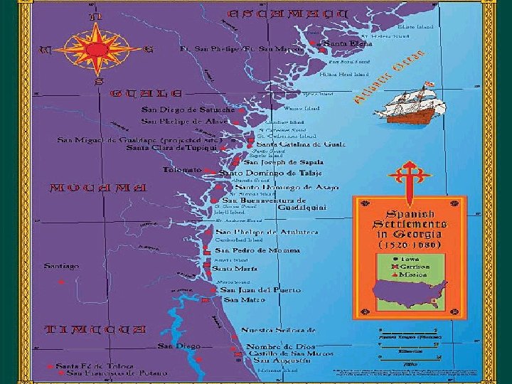
SS 8 H 1 Evaluate the impact of European exploration and settlement on American Indians in Georgia. a. Describe the characteristics of American Indians living in Georgia at the time of European contact; to include culture, food, weapons/tools, and shelter. b. Explain reasons for European exploration and settlement of North America, with emphasis on the interests of the Spanish and British in the Southeastern area. c. Evaluate the impact of Spanish contact on American Indians, including the explorations of Hernando De. Soto and the establishment of Spanish missions along the barrier islands. 56

57

4 Early periods of Native American cultures: • Paleo Indians (18, 000 BC to 8, 000 BC) – Nomadic hunters; Used Atlatl • Archaic Indians (8, 000 BC to 1, 000 BC) – Hunter gatherers; Used tools like axes • Woodland Indians (1, 000 BC to 1, 000 AD) – Simple farming + hunting & gathering; Used bows and arrows – Small villages/ tribes • Mississippian Indians (800 AD to 1500 AD) – Advanced farming – Complex societies 58

https: //www. youtube. com/watch? v=Bk. K 2 v. EZ 5 b. Tk https: //www. youtube. com/watch? v=hj. V 7 l. YP 6 h. Rw 59

Mississippian Indians • Complex religious society ruled by a few elites • Large villages – Wood & clay houses, defensive structures, Temple Mounds • Large scale agriculture – Mainly corn; also pumpkin, squash & beans • Improved stone tools • Decline due to European interaction 60

61

European Exploration/ Settlement of North America • Spanish reasons – The 3 G’s: • Gold- Wealth • God- Spreading Christianity • Glory- Personal fame • British reasons – Mercantilism: the idea where a “mother” country gains colonies for their natural resources & brings them back to make goods 62

Hernando De Soto • 1 st European to explore GA interior- 1540 • Searched for gold but none & eventually died; was buried in the Mississippi River • Many Native Americans died due to killing/ torture & disease – Smallpox, measles, influenza • Although he failed he changed the lives of Native Americans forever 63

64

65

66

67
 were set up on the barrier islands – Mainly")
Spanish Missions • Missions (churches) were set up on the barrier islands – Mainly for Christianity but also used for trade, deterrent. – Were more successful at colonization than the explorers – Slave revolts, population decline & pirate raids led to an end of the Mission system • 1684 - Spanish Missions in Ga. ended 68

70
- Slides: 70