
SPIE Remote Sensing 2013 Dresdsen APPLICATION OF MAIAC


- Slides: 20
SPIE Remote Sensing 2013 - Dresdsen APPLICATION OF MAIAC HIGH SPATIAL RESOLUTION AEROSOL RETRIEVALS OVER PO VALLEY (ITALY) Barbara Arvani(1), (*), R. Bradley Pierce(2), Alexei I. Lyapustin(3), Yujie Wang(4), Sergio Teggi(1), Grazia Ghermandi(1) University of Modena and Reggio Emilia, Italy (2) NOAA/NESDIS Advanced Satellite Products Branch, Madison (WI), USA (3) NASA Goddard Space Flight Center, code 613, Greenbelt, Maryland 20771 USA (4) University of Maryland, Baltimore County, 1000 Hilltop Circle, Baltimore, MD, USA (*) Cooperative Institute for Meteorological Satellite Studies, Madison (WI), USA 1
SPIE Remote Sensing 2013 - Dresdsen • Outline: • Objectives • Area of interest: Po Valley Domain • Dataset • PM 10 ground stations • MODIS: MYD 04 and MAIAC AODs • AERONET AOD • Planetary Boundary Layer height (ZPBL) • MYD 04 and MAIAC test using AERONET data • Vertical distribution of aerosols: ZPBL correction • PM 10 – AOD: Monthly trend • PM 10 – AOD: Correlation • PM 10 – AOD: Effect of ZPBL • Conclusion 2
SPIE Remote Sensing 2013 - Dresdsen • What Study of correlation between Particulate Matter measured by ground monitoring stations and aerosol information retrieved by MODIS sensor Ground measurements: • Particulate Matter with aerodynamic diameter less than 10 m (PM 10) obtained by regional monitoring agencies in the Po Valley, North of Italy Aerosol Optical Depth (AOD): • Obtained from the standard MODIS Aqua Collection 5. 1 (MYD 04 product), with a spatial resolution of 10 x 10 km 2 • By MAIAC (Multi-Angle Implementation of Atmospheric Correction) algorithm, with a spatial resolution of 1 x 1 km 2 3
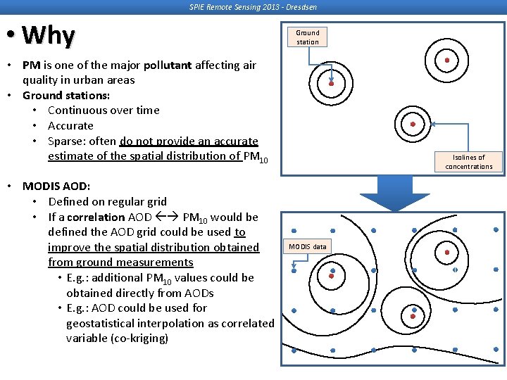
SPIE Remote Sensing 2013 - Dresdsen • Why Ground station • PM is one of the major pollutant affecting air quality in urban areas • Ground stations: • Continuous over time • Accurate • Sparse: often do not provide an accurate estimate of the spatial distribution of PM 10 • MODIS AOD: • Defined on regular grid • If a correlation AOD PM 10 would be defined the AOD grid could be used to improve the spatial distribution obtained from ground measurements • E. g. : additional PM 10 values could be obtained directly from AODs • E. g. : AOD could be used for geostatistical interpolation as correlated variable (co-kriging) Isolines of concentrations MODIS data 4
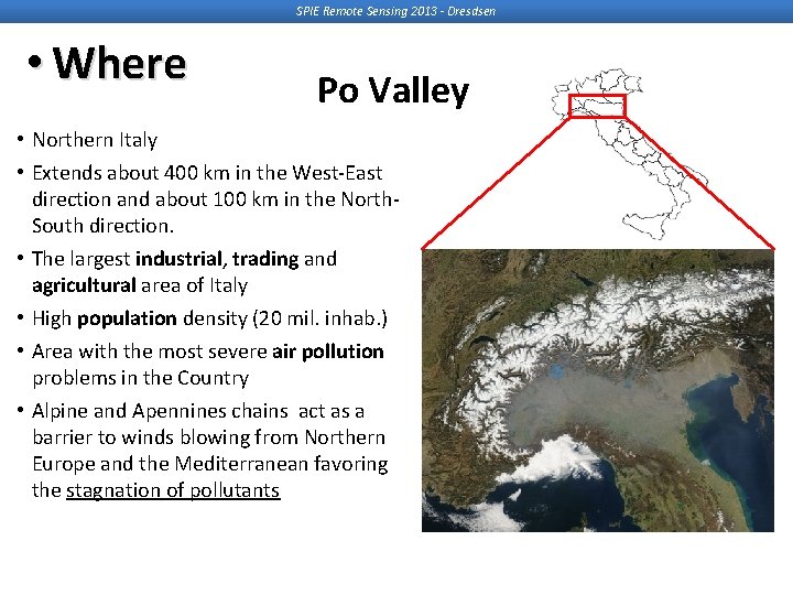
SPIE Remote Sensing 2013 - Dresdsen • Where Po Valley • Northern Italy • Extends about 400 km in the West-East direction and about 100 km in the North. South direction. • The largest industrial, trading and agricultural area of Italy • High population density (20 mil. inhab. ) • Area with the most severe air pollution problems in the Country • Alpine and Apennines chains act as a barrier to winds blowing from Northern Europe and the Mediterranean favoring the stagnation of pollutants
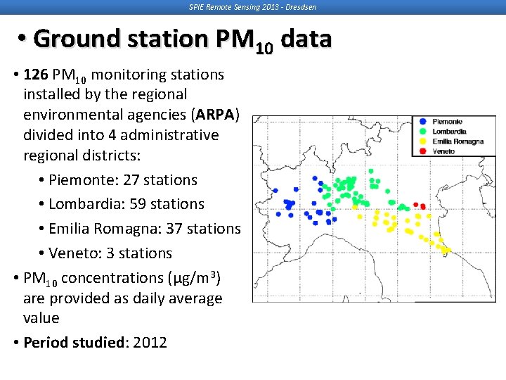
SPIE Remote Sensing 2013 - Dresdsen • Ground station PM 10 data • 126 PM 10 monitoring stations installed by the regional environmental agencies (ARPA) divided into 4 administrative regional districts: • Piemonte: 27 stations • Lombardia: 59 stations • Emilia Romagna: 37 stations • Veneto: 3 stations • PM 10 concentrations (µg/m 3) are provided as daily average value • Period studied: 2012
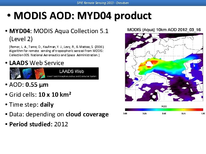
SPIE Remote Sensing 2013 - Dresdsen • MODIS AOD: MYD 04 product • MYD 04: MODIS Aqua Collection 5. 1 (Level 2) [Remer, L. A. , Tanre, D. , Kaufman, Y. J. , Levy, R. , & Mattoo, S. (2006). Algorithm for remote sensing of tropospheric aerosol from MODIS: Collection 005. National Aeronautics and Space Administration. ] • LAADS Web Service • AOD: 0. 55 µm • Grid cells: 10 x 10 km 2 • Time step: daily • Data: depending on cloud coverage • Period studied: 2012
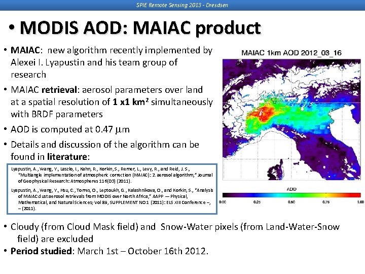
SPIE Remote Sensing 2013 - Dresdsen • MODIS AOD: MAIAC product • MAIAC: new algorithm recently implemented by Alexei I. Lyapustin and his team group of research • MAIAC retrieval: aerosol parameters over land at a spatial resolution of 1 x 1 km 2 simultaneously with BRDF parameters • AOD is computed at 0. 47 m • Details and discussion of the algorithm can be found in literature: Lyapustin, A. , Wang, Y. , Laszlo, I. , Kahn, R. , Korkin, S. , Remer, L. , Levy, R. , and Reid, J. S. , “Multiangle implementation of atmospheric correction (MAIAC): 2. aerosol algorithm, ” Journal of Geophysical Research: Atmospheres 116(D 3) (2011). Lyapustin, A. , Wang, Y. , Hsu, C. , Torres, O. , Leptoukh, G. , Kalashnikova, O. , and Korkin, S. , “Analysis of MAIAC dust aerosol retrievals from MODIS over North Africa, ” AAPP — Physical, Mathematical, and Natural Sciences; Vol 89, SUPPLEMENT NO 1 (2011): ELS XIII Conference –, – (2011). • Cloudy (from Cloud Mask field) and Snow-Water pixels (from Land-Water-Snow field) are excluded • Period studied: March 1 st – October 16 th 2012.
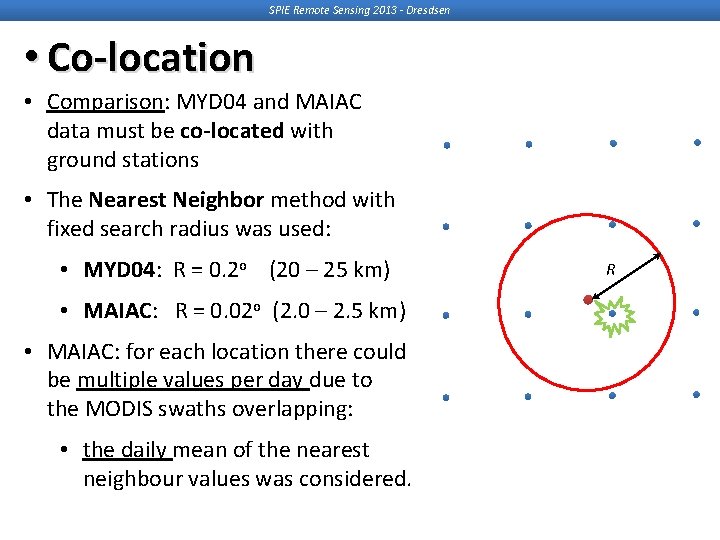
SPIE Remote Sensing 2013 - Dresdsen • Co-location • Comparison: MYD 04 and MAIAC data must be co-located with ground stations • The Nearest Neighbor method with fixed search radius was used: • MYD 04: R = 0. 2 o (20 – 25 km) R • MAIAC: R = 0. 02 o (2. 0 – 2. 5 km) • MAIAC: for each location there could be multiple values per day due to the MODIS swaths overlapping: • the daily mean of the nearest neighbour values was considered. 9
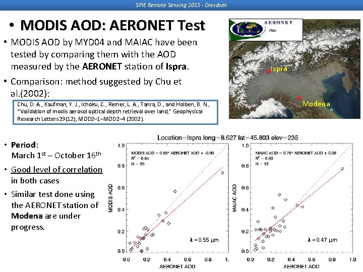
SPIE Remote Sensing 2013 - Dresdsen • MODIS AOD: AERONET Test • MODIS AOD by MYD 04 and MAIAC have been tested by comparing them with the AOD measured by the AERONET station of Ispra. • Comparison: method suggested by Chu et al. (2002): Chu, D. A. , Kaufman, Y. J. , Ichoku, C. , Remer, L. A. , Tanra, D. , and Holben, B. N. , “Validation of modis aerosol optical depth retrieval over land, ” Geophysical Research Letters 29(12), MOD 2– 1–MOD 2– 4 (2002). Ispra Modena • Period: March 1 st – October 16 th • Good level of correlation in both cases • Similar test done using the AERONET station of Modena are under progress. λ = 0. 55 µm λ = 0. 47 µm
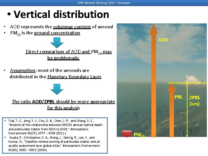
SPIE Remote Sensing 2013 - Dresdsen • Vertical distribution • AOD represents the columnar content of aerosol • PM 10 is the ground concentration AOD Direct comparison of AOD and PM 10 may be problematic • Assumption: most of the aerosols are distributed in the Planetary Boundary Layer PBL The ratio AOD/ZPBL should be more appropriate for this analysis • Tsai, T. -C. , Jeng, Y. -J. , Chu, D. A. , Chen, J. -P. , and Chang, S. -C. , “Analysis of the relationship between MODIS aerosol optical depth and particulate matter from 2006 to 2008, ” Atmospheric Environment 45(27), 4777 – 4788 (2011). • Gupta, P. , Christopher, S. A. , Wang, J. , Gehrig, R. , Lee, Y. , and Kumar, N. , “Satellite remote sensing of particulate matter and air quality assessment over global cities, ” Atmospheric Environment 40(30), 5880 – 5892 (2006). PM 10 ZPBL (km)
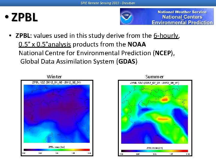
SPIE Remote Sensing 2013 - Dresdsen • ZPBL: values used in this study derive from the 6 -hourly, 0. 5° x 0. 5°analysis products from the NOAA National Centre for Environmental Prediction (NCEP), Global Data Assimilation System (GDAS) Winter Summer
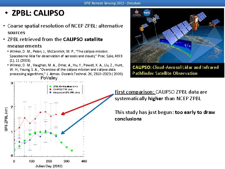
SPIE Remote Sensing 2013 - Dresdsen • ZPBL: CALIPSO • Coarse spatial resolution of NCEP ZPBL: alternative sources • ZPBL retrieved from the CALIPSO satellite measurements • Winker, D. M. , Pelon, J. , Mc. Cormick, M. P. , “The calipso mission: Spaceborne lidar for observation of aerosols and clouds, ” Proc. Spie, 4893 (1), 11 (2003). • Winker, D. M. , Vaughan, M. A. , Omar, A. , Hu, Y. , Powell, K. A. , Liu, Z. , Hunt, W. H. , Young, S. A. , “Overview of the calipso mission and calipso data processing algorithms, ” J. Atmos. Oceanic Technol. 26, 2310– 2323 ( 2009). Summer CALIPSO: Cloud-Aerosol Lidar and Infrared Pathfinder Satellite Observation First comparison: CALIPSO ZPBL data are systematically higher than NCEP ZPBL This study has just begun: too early to draw conclusions
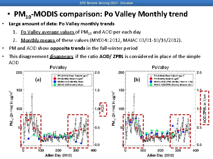
SPIE Remote Sensing 2013 - Dresdsen • PM 10 -MODIS comparison: Po Valley Monthly trend • Large amount of data: Po Valley monthly trends 1. Po Valley average values of PM 10 and AOD per each day 2. Monthly means of these values (MYD 04: 2012, MAIAC 03/01 -10/16/2012). • PM and AOD show opposite trends in the fall-winter period • This disagreement disappears if the ratio AOD/ ZPBL is considered in place of the simple AOD 14
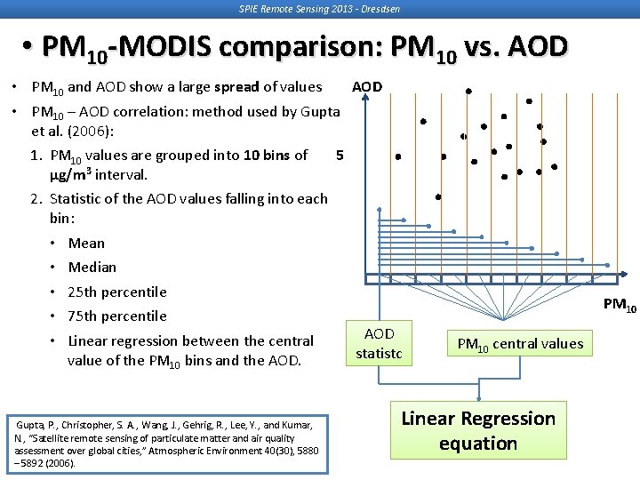
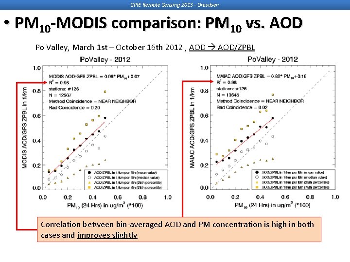
SPIE Remote Sensing 2013 - Dresdsen • PM 10 -MODIS comparison: PM 10 vs. AOD • PM 10 and AOD show a large spread of values • PM 10 – AOD correlation: method used by Gupta et al. (2006): 1. PM 10 values are grouped into 10 bins of 5 µg/m 3 interval. 2. Statistic of the AOD values falling into each bin: • Mean • Median • 25 th percentile • 75 th percentile AOD • Linear regression between the central statistc value of the PM 10 bins and the AOD. Gupta, P. , Christopher, S. A. , Wang, J. , Gehrig, R. , Lee, Y. , and Kumar, N. , “Satellite remote sensing of particulate matter and air quality assessment over global cities, ” Atmospheric Environment 40(30), 5880 – 5892 (2006). PM 10 central values Linear Regression equation
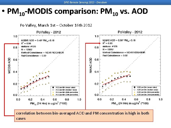
SPIE Remote Sensing 2013 - Dresdsen • PM 10 -MODIS comparison: PM 10 vs. AOD Po Valley, March 1 st – October 16 th 2012 correlation between bin-averaged AOD and PM concentration is high in both cases
SPIE Remote Sensing 2013 - Dresdsen • PM 10 -MODIS comparison: PM 10 vs. AOD Po Valley, March 1 st – October 16 th 2012 , AOD/ZPBL Correlation between bin-averaged AOD and PM concentration is high in both cases and improves slightly
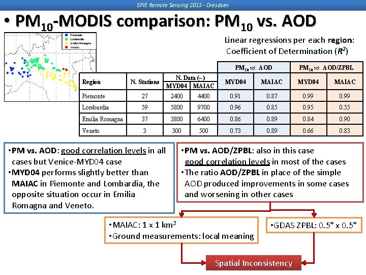
SPIE Remote Sensing 2013 - Dresdsen • PM 10 -MODIS comparison: PM 10 vs. AOD Linear regressions per each region: Coefficient of Determination (R 2) Region PM 10 vs. AOD N. Stations N. Data (~) MYD 04 MAIAC PM 10 vs. AOD/ZPBL MYD 04 MAIAC Piemonte 27 2400 4400 0. 91 0. 87 0. 99 Lombardia 59 5800 9700 0. 96 0. 85 0. 95 0. 55 Emilia Romagna 37 3800 6400 0. 86 0. 89 0. 84 0. 90 Veneto 3 300 500 0. 73 0. 89 0. 66 0. 83 • PM vs. AOD: good correlation levels in all cases but Venice-MYD 04 case • MYD 04 performs slightly better than MAIAC in Piemonte and Lombardia, the opposite situation occur in Emilia Romagna and Veneto. • PM vs. AOD/ZPBL: also in this case good correlation levels in most of the cases • The ratio AOD/ZPBL in place of the simple AOD produced improvements in some cases and worsening in other cases • MAIAC: 1 x 1 km 2 • Ground measurements: local meaning • GDAS ZPBL: 0. 5° x 0. 5° Spatial Inconsistency
SPIE Remote Sensing 2013 - Dresdsen • Conclusions and Further Developments • MAIAC 1 km retrieval provides high resolution information on Aerosol Optical Depth within the highly industrialized Po valley of Northern Italy • Correlation between ground stations measurements of PM 10 and AOD obtained by MODIS standard products (MYD 04, 10 x 10 km 2) and by MAIAC algorithm (1 x 1 km 2) over the Po valley seems satisfactory • PM 10 vs. AOD MYD 04 and PM 10 vs. AOD MAIAC linear regression should be improved if the AOD is normalized by the PBL depth: • As first step, we used PBL Depth data derive from 6 hourly 0. 5° ∙ 0. 5° degree analysis files from the NOAA NCEP Global Data Assimilation System (GDAS) • The results are positive if the entire Po Valley domain is considered, but they show some ambiguities if they are considered separately for each region • This last result indicates a probable spatial inconsistency between the data sets • Similar test using the ZPBL extracted from the CALIPSO satellite products are under progress • The correlation between ground PM 10 and MAIAC AOD should permits a better reconstruction of the PM 10 spatial distribution over most of the Po valley.
SPIE Remote Sensing 2013 - Dresdsen Thank you! Any question?