SPATIAL DATA QUALITY CONT Data quality standards must


 Urban (Residential , Commercial, Industry) Water")


- Slides: 29
SPATIAL DATA QUALITY
CONT. • Data quality standards must serve the needs of the users according to their budget, technical capabilities, and rate of production.
COMPONENTS OF SPATIAL DATA QUALITY • There are 9 components that affect the quality of the data. • These components have been grouped into 3 categories are: • 1. Micro Level Components • 2. Macro Level Components • 3. Usage Components.
Micro Level Components
MICRO LEVEL COMPONENTS • Micro level components are data quality factors that pertain to the individual data elements. • Positional Accuracy • Attribute Accuracy • Logical Consistency • Resolution
MICRO LEVEL COMPONENTS Positional Accuracy: • is the expected deviation in the geographic location of an object in the data set from its true position • There are two components to positional accuracy are; • Bias • Precision • The bias refers to the systematic discrepancies between the represented and true position. Ideally the bias should be zero. • Bias is commonly measured by the mean / Average positional error of the sample points.
MICRO LEVEL COMPONENTS Positional Accuracy: • Precision refers to the dispersion of the positional errors of the data elements. • Precision is commonly estimated by calculating the standard deviation of the selected test points. • A low standard deviation indicates that the data points tend to be very close to the mean • Higher the precision better the data for use. • Commonly the accuracy is measured in RMS error.
MICRO LEVEL COMPONENTS • Attribute Accuracy: may be discrete or continuous variables. • A discrete variable can take on only a finite number of values e. g. Land use class, Vegetation type, or administrative boundaries. • Ratings is also discrete variables. They are ordered in categories where the order indicates the hierarchy of the attribute. • Low (1) to High (4)
MICRO LEVEL COMPONENTS Attribute Accuracy: • Continuous variables can take on any number of value. • Temperature • Average property value are continuous • Hence, the variable can take on any value so intermediate values are valid.
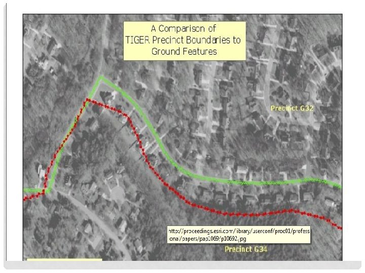
MICRO LEVEL COMPONENTS • Logical Consistency: refers to how well logical relations among data elements are maintained. • For Example • There must be a consistency between forest stand boundaries and to the center of adjacent roads • Political and administrative boundaries defined by physical features should precisely overlay those features. • The edge of the property that borders a lake should coincide with the lake boundary.
MICRO LEVEL COMPONENTS
MICRO LEVEL COMPONENTS • Logical Consistency: is best addressed before data are entered in GIS data base. Hence, there is no standard measure of logical consistency. • � The map preparation stage includes to check, redraft (correct errors), and reconcile discrepancies , known as conflation process.
MICRO LEVEL COMPONENTS • Resolution: of a data set is the smallest understandable unit or the smallest unit represented. • In aerial camera or in satellite images the smallest units that can be understood , called spatial resolution. • Area of the earth’s surface represented in a single digital image value is known as spatial resolution. • For thematic maps such as soil maps, land use maps, the resolution is the size of the smallest object that is represented , called minimum mapping unit.
MICRO LEVEL COMPONENTS • Resolution: But geographic data stored in GIS data base can be represented at any scale. • Labeling and other map details can be added according to the required output scale. • Data do not have a specific scale, they are produced according to the resolution and accuracy required to produce intended results.
Macro Level Components
MACRO LEVEL COMPONENTS • Macro level components of data quality pertain to the data set as a whole. • Such as; • Completeness • Time • Lineage
MACRO LEVEL COMPONENTS • Completeness: is further sub divided into three parts are; • Completeness of coverage • Completeness of classification • Completeness of verification • The completeness of coverage is the proportion of data available for area of interest. • A data set may not provide complete aerial view or attribute data may not be available some of the data set.
MACRO LEVEL COMPONENTS • Completeness of classification is an assessment of how well the cohesion classification is able to represent the data.
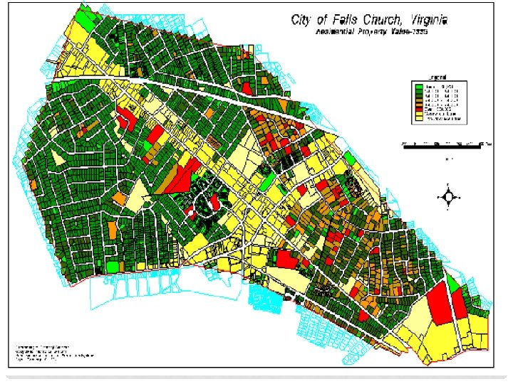
MACRO LEVEL COMPONENTS Forest (Conifer and deciduous classification) Urban (Residential , Commercial, Industry) Water (Salinity classification) Agriculture • Grains • Truck crops • Carrots • Tomatoes • Other Live stock • Cattle • Hog • Sheep
MACRO LEVEL COMPONENT • Completeness of Verification refers to field measurements or other independence sources of information that were used to develop the data. For example • A geologist can verify the quality of the data by applying solid line to a map rocks types as he has direct field evidence.
MACRO LEVEL COMPONENT • Time: is very important factor when using different types of geographic data such as demographic, Land cover. • The time aspect of data quality is most commonly reported as the date of the source material , such as the date of aerial photography. • Topographic maps include updated information. • Forest inventory maps may be updated on a 5 to 10 years. • Crop condition changes rapidly , hence updated on a weekly basis. • Flood prone areas map are updated on daily basis.
MACRO LEVEL COMPONENT • Lineage: Processing steps to produce a data set is called lineage. • Transaction records • field notes • air photos and other maps. • Each data source and processing method introduces a level of error into the information that is ultimately produced.
Usage Components
USAGE COMPONENTS • • Accessibility: refers to the ease of obtaining data. Government held data Privately held data Direct and indirect cost of the data
SOURCES OF ERROR • Data collection • Data input • Error in field data collection • Error in base map • Error in the analysis of remote sensing data • Digitization error by operator or equipment
SOURCES OF ERROR • Data storage • Data management • Insufficient numerical precision • Insufficient spatial precision • Inappropriate class intervals • slivers
SOURCES OF ERROR • Data out put • Scaling inaccuracies • Error caused by inaccurate of the output devices • Use of result • Information may be incorrectly understand • Information may be inappropriately used