Spatial Data Elements Levels and Types Spatial Data


 l specifies location § Attribute data")


 Aerial")


- Slides: 23
Spatial Data: Elements, Levels and Types
Spatial Data: What GIS Uses Bigfoot Sightings: Spatial Data
A GIS Provides the Ability to Analyze Disparate Data Sets Based on Location
Spatial and Attribute Data § Spatial data (where) l specifies location § Attribute data (what) l l specifies what is at that location stored in a database table § A GIS will link spatial and attribute data for display or analysis
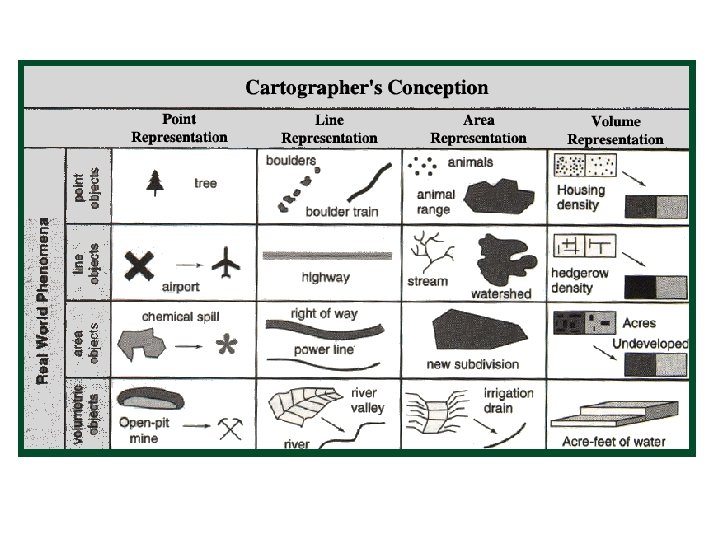
Spatial Elements 4 Types of Phenomena
Points 1 2 3 4 § Points occur at one location in space. § Examples include houses, trees etc. § Discrete or fixed: Occupies one space at any time. § Moving: Examples include, cars, fish, deer § They have no spatial dimension.
Lines § Occupy a single dimension. § Examples include: roads, boundaries, and networks. § Do not have a width, but length can be measured.
Area 3 1 2 § § § 2 -dimensional objects Length and width can be measured Surfaces, which include two types: Discrete, has a definite boundary ex: towns Continuous, has a changing boundary ex: meandering river
Volume § 3 -dimensional. § Examples include the volume of water in a lake, air masses. § Continuous data includes: elevation, rainfall, ocean salinity § Moving data includes: air masses, animal herds, schools of fish
GIS Attempts to Describe All Features in Geometric Terms. § Points: surveyed locations, new construction, community resources § Lines: roads, transit routes § Areas: parcel maps, zip codes, census tracts
Data Types - 4 Types § nominal • no inherent ordering • land use types, county names • yes or no data § ordinal • • inherent order road class; stream class hierarchy can be compared § interval • known distance between values • no natural zero • can be compared § ratio • natural zero • ratios make sense (e. g. twice as much) • income, age, rainfall
Data Types
GIS Links Spatial Data with Attribute Data for a Feature on a Map The information is stored as ‘attributes’ of the graphically represented feature. Roads Map Feature List Attribute Table 4 6 1 2 3 5 Example: A line that denotes a road shows its location. An attribute table stores all relevant information about this feature, which can be queried and displayed in a format based on the user’s needs
There are Two Ways to Acquire Spatial Data to Put Into a GIS 1. You purchase, or are given an existing data set 2. You go out and collect the data yourself
Major GIS Data Sources § § § § Maps Drawings (sketch or engineering) Aerial (or other) Photographs Satellite Imagery/Digital Ortho Photography CAD data bases Government & commercial spatial (GIS) data bases Government & commercial attribute data bases Paper records and documents
Where do we get the data? § Purchase the data already processed and ready to use. § Purchase the data and then complete the processing. § Get original data in office or lab. § Get original data in the field.
Existing Data § Purchase satellite images/ aerial photography already processed § Find public domain sources of images. Or share costs with data partners. § Purchase or download data and process inhouse.
Existing Data § We may purchase or share an attribute data base (Excel spreadsheet, or Access database). § Must have a spatial component. § Sometimes we must “clean” the data.
Data Collection § § Compile data directly from air-photos. Digitize from existing paper maps Scan from existing maps Field data collection. Hand-held, mobile and airborne GPS (Global Positioning Systems).
Creating your own data Most GIS users still must create their own data or need to update it Manual Digitizing Raster Scanning
Pre-processing and Conversion: usually required! § Maps and Drawings l l digitizing, or scanning § GIS Data Bases l § Aerial Photographs l l photogrametry/photo interpretation to extract features digitizing or scanning to convert to digital § Satellite Imagery/ Digital Orthophotography l rectification and DEM (digital elevation model) § CAD Data Bases l translator software (pre-existing or custom-written) needed to convert to required GIS format l conversion between proprietary standards (ARC/INFO, Intergraph, GDS, etc. ) Spatial Data Transfer Standard § Attribute Databases l l geocoding if micro data conversion between geographic units § Records and Documents l l l OCR (optical character recognition) scanning keyboarding then, same as attribute data bases
Representation of space elements. . . A 1 S 1 P 1 A 3 S 2 P 3 A 4 P 4 A 8 Human Perception P 2 A 6 P 5 A 5 S 4 P 7 P 8 P 9 A 11 S 3 P 6 A 7 P 10 P 11 A 12 Arc-ID Nœud_F 1 1 1 2 2 5 3 4. . . 3 5 3 4 Computer Perception S 6 S 5 P 12 A 13 Arc-ID (X, Y) 1 2 3 4. . . (a, b) , . . . , (a, b) (c, d) , . . . , (e, f) (g, h), . . . , (g, h) (e, f) , . . . , (g, h) Spatial Data. Base