Southern Eastern Asia POPULATION TRADE Presentation Graphic Organizers




- Slides: 85

Southern & Eastern Asia POPULATION & TRADE Presentation, Graphic Organizers, & Activities

Weekly Agenda: 2 -15 to 2 -19 -21 Weekly Opening: • Journal Writing • Citizenship Word of the Week: • Current Events • CNN 10 Weekly Work Period: • SE Asia’s Map Skills Review (Countries and Physical Features) (ongoing review of map skills) • SE Asia’s Population and Trade Cloze Notes 1 -3 The students will use Power. Point presentation to complete the cloze notes.

Weekly Agenda: 2 -15 to 2 -19 -21 Weekly Work Period cont’: • SE Asia’s Population and Trade chart Students will use guided notes to complete the chart. Once finished, we will check answers as a class. If time permits, students will color their pictures. • SE Asia’s Real Estate Brochure The students will imagine they are real estate agents that have clients looking to buy in Southern and Eastern Asia. They will create a brochure that showcases the location, climate, natural resources, physical characteristics, population distribution, etc. of the mountains, deserts, and water features in SE Asia. • SE Asia’s Quick Pic Activity In the textbox, the students will write an opinion statement of where they’d prefer to live in Southern and Eastern Asia (mountains, desert, water feature). They should include information about the region’s location, climate, natural resources, population, available jobs, etc. In the camera lens, they will draw something significant about the place that they chose.

Weekly Agenda: 2 -15 to 2 -19 -21 Weekly Closing: • SE Asia’s Environmental Issues Comprehension Check • SE Asia’s Population and Trade Comprehension Check Students will complete the assignment after discussing the presentation. This will count as a quiz! • SE Asia Ticket Out The Door “Think About It” Activity Students will complete the chart with information about how the geographies of the features affect where people choose to live.

Weekly Assessment/Technology Tools: 2 -15 to 2 -19 -21 • SE Asia’s Map Test • SE Asia’s Population and Trade Comprehension Check • SE Asia’s Think About It Activity • USA Testprep (graded assignment; class time is given but can be completed at home) • Edpuzzle Videos (graded assignment; class time is given but can be completed at home) • Discovery Education (graded assignment; class time is given but can be completed at home)

Journal Topics: 2 -15 -21 2 -16 -21 2 -17 -21 2 -18 -21 2 -19 -21 Student Holiday Should Everyone Have Healthcare Current Event Wednesday/CNN 10 Education For Men Only Teen Issue

2 -15 -21

Journal Topic: 2 -16 -21 Should Everyone Have Health Care Do you know some people do not have health care because they cannot afford it? Imagine a time when you were very sick and needed the attention of a doctor. Doctors take an oath to save lives, but imagine not having money to pay for the service. Do you think everyone should have health care even if they can not pay for it? Explain. (5 or more sentences)

Citizenship: 2 -16 -21: Cheerfulness is defined as the state of being happy and positive. On a scale of one to five, how important is it for you to be cheerful. Explain.


Ruby Bridges https: //www. youtube. com/watch? v=E 3 z. Euni 5 o. Es

Condoleeza Rice https: //www. youtube. com/watch? v=v. Mqk. Hq_ 4 e. E 0&list=PLjn. L 2 NSDUI 6 bxh. LT 7 Dajl-Xkzq. UTC 8 EK&index=94

Journal Topic: 2 -17 -21 Change About Self We can’t always change things about ourselves, but you might be able to change more than you think. What would you like to change about yourself? Why? (5 or more sentences)


2 -17: Dr. Mae C. Jemison https: //www. youtube. com/watch? v=rv. Uf. EQV 7 Xf. I

Current Event Wednesday: 2 -17 -21 CNN 10 Three students will be randomly chosen to share out articles. Students who refuse to share out will lose points. (Each student must do one article per week and will receive a current event grade. ) https: //www. cnn. com/cnn 10

Journal Topic: 2 -18 -21 Education for Men Only Some countries don’t think women should have the right to an education. Do you think that education should be for men only? Why or why not? Explain. (minimum of 5 complete sentences).

Citizenship: 2 -18 -21: Cheerfulness is defined as the state of being happy and positive. On a scale of one to five, how important is it for you to have friends who exhibits cheerfulness? Explain


14 th Amendment https: //www. youtube. com/watch? v=Ej 7 TVJ 4 F R 4 E&list=PLjn. L 2 NSDUI 6 balkz. EUa. Qev. Yj. Imzg. Xe 4 Dx&index=35

Emmett Till https: //www. youtube. com/watch? v=8 ojlufr. Qj 2 w&list=PLjn. L 2 NSDUI 6 balkz. EUa. Qev. Yj. Imzg. Xe 4 Dx&index=15

Journal Topic: 2 -19 -20 Teen Issue What is the most important issue facing teens your age today? What are some ways you think teens can deal with the issue? (minimum of 5 complete sentences).


Reconstruction Amendments https: //www. youtube. com/watch? v=Cpi. H 2 b 92 3 pc

Colin Powell https: //www. youtube. com/watch? v=Cy 7 h. Bru. B F 6 s

STANDARDS: SS 7 G 11 Explain the impact of location, climate, physical characteristics, distribution of natural resources, and population distribution on Southern and Eastern Asia. a. Describe how the mountain, desert, and water features of Southern and Eastern Asia impact trade and affect where people live. © Brain Wrinkles

TEACHER INFO: CLOZE Notes • The next pages are handouts for the students to use for note-taking during the presentation. (Print front to back to save paper and ink. ) • Check the answers as a class after the presentation. © Brain Wrinkles

POPULATION & TRADE CLOZE Notes 1 Asia • The vast continent of Asia has ______________ mountain, desert, and water features. • ______________ are located in the north, while steamy rainforests lie in the south. • A large part of Asia is desert, yet much of southern and eastern Asia receives massive ______________ each year. • These features impact trade and affect ______________. IMPACT OF MOUNTAINS Himalayas • The Himalayas are a mountain range with some of the ______________ in the entire world. • They have a significant ______________ in southwest China and northwest India. • ______________ have been built on glaciers throughout the range, which supplies energy throughout the region. • ______________ from the rest of Asia on three sides by mountain ranges. • On India’s side of the Himalayas, the high ______________ , so rainforests and grasslands can be found. • The Chinese side of the icy Himalayas receives ______________ and the population is much lower here. Tibetan Plateau • The Tibetan Plateau covers the ______________ and is the world’s highest plateau at 14, 800 feet above sea level. • Because of the region’s ______________ , it has been nicknamed “the roof of the world”. • Many of Asia’s major rivers begin in the Tibetan Plateau, and are fed by more than ______________ that are located here. • In this region, summers are very short and winters are ______________. • During the few warmer months, farmers are able to let ______________ in the region’s grasslands. • Overall, this region has a ______________ of only two persons per square mile. © Brain Wrinkles

POPULATION & TRADE CLOZE Notes 2 IMPACT OF DESERTS Gobi Desert • The Gobi Desert is located in northern China and is ______________. • The region is extremely dry and the southern portion of the desert is ______________. • The Gobi is known for its ______________ with winter lows of -40°F and summer highs above 120°F. • ______________ is done in the Gobi Desert, but it is not enough to support large cities. • The ______________ of the Gobi travels with its herds of small livestock looking for oases. • Inhabitants use ______________ through the desert. Taklimakan • The unforgiving Taklimakan Desert is one of the ______________ in the world. • It ______________ or other water sources. • Like the Gobi, the Taklimakan Desert also has ______________ that vary across the region. • ______________ in the Taklimakan, but shifting sand dunes make it nearly impossible for people to get to work locations. • Few people other than ______________ inhabit the region. IMPACT OF WATER Water • Many Asian countries have ______________ and millions of people live along the ocean. • Southern and Eastern Asia have large port cities where ______________ are important industries that provide numerous jobs. • Millions of other people throughout Southern and Eastern Asia ______________. • These water sources provide them with water for ______________. © Brain Wrinkles

POPULATION & TRADE CLOZE Notes 3 Huang He • The Huang He River basin is located in ______________. • This area is home to more than ______________. • The Huang He River valley receives an abundance of rainfall and the ______________. • The ______________ to transport people and goods throughout the region. Yangtze • The Yangtze River is ______________ and it is located in southeast China. • The Yangtze River basin ______________ that flows into the river. • Flooding of the Yangtze River keeps the region’s soil fertile (______________ is located here). • The Yangtze River allows ships to ______________ from around the world to China’s inland cities. • ______________ are located along the Yangtze River. • __________, with a population of 22 million people, is located here. Ganges • The Ganges River starts on a glacier high in the Himalayan Mountains and winds 1500 miles through ______________. • It is the ______________ in the world, with over 1, 000 people per square mile. • The river is ______________ by the Hindu religion and is worshipped as the goddess Ganga. • The Ganges River is the ______________ in the Indian subcontinent. • Indians use the Ganges for irrigation, drinking water, fishing, and for ______________. • Ships carry ______________ down the Ganges River. • Delhi, one of India’s most populated cities with ______________ , is located along the Ganges. © Brain Wrinkles

Southern & Eastern Asia: POPULATION & TRADE © Brain Wrinkles

Asia • The vast continent of Asia has many different mountain, desert, and water features. • Icy mountain ranges are located in the north, while steamy rainforests lie in the south. • A large part of Asia is desert, yet much of southern and eastern Asia receives massive amounts of rain each year. • These features impact trade and affect where people live. © Brain Wrinkles

Physical Features © Brain Wrinkles

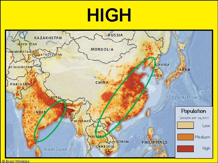
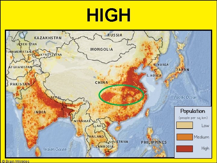
Southern and Eastern Asia’s Population Density © Brain Wrinkles

Impact of Mountains © Brain Wrinkles

Himalayas • The Himalayas are a mountain range with some of the tallest peaks in the entire world. • They have a significant impact on life in southwest China and northwest India. • Hydroelectric power plants have been built on glaciers throughout the range, which supplies energy throughout the region. © Brain Wrinkles

© Brain Wrinkles

Himalayas • India is separated from the rest of Asia on three sides by mountain ranges. • On India’s side of the Himalayas, the high mountains trap rain clouds, so rainforests and grasslands can be found. • The Chinese side of the icy Himalayas receives very little rainfall and the population is much lower here. © Brain Wrinkles

© Brain Wrinkles

Tibetan Plateau • The Tibetan Plateau covers the majority of western China and is the world’s highest plateau at 14, 800 feet above sea level. • Because of the region’s extremely high elevations, it has been nicknamed “the roof of the world”. • Many of Asia’s major rivers begin in the Tibetan Plateau, and are fed by more than 30, 000 glaciers that are located here. © Brain Wrinkles

© Brain Wrinkles

Tibetan Plateau • In this region, summers are very short and winters are long and extremely cold. • During the few warmer months, farmers are able to let livestock graze in the region’s grasslands. • Overall, this region has a low population density of only two persons per square mile. © Brain Wrinkles

© Brain Wrinkles

Impact of Deserts © Brain Wrinkles

Gobi Desert • The Gobi Desert is located in northern China and is Asia’s largest desert. • The region is extremely dry and the southern portion of the desert is completely waterless. • The Gobi is known for its extreme temperatures with winter lows of -40°F and summer highs above 120°F. © Brain Wrinkles

© Brain Wrinkles

Gobi Desert • Some mining is done in the Gobi Desert, but it is not enough to support large cities. • The small nomadic population of the Gobi travels with its herds of small livestock looking for oases. • Inhabitants use camels to travel through the desert. © Brain Wrinkles

© Brain Wrinkles

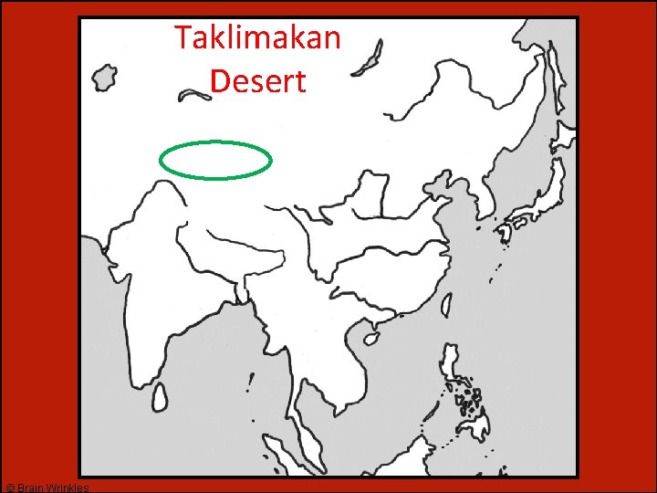
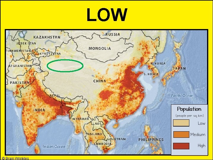
Taklimakan • The unforgiving Taklimakan Desert is one of the sandiest places in the world. • It lacks adequate rainfall or other water sources. • Like the Gobi, the Taklimakan Desert also has extreme temperatures that vary across the region. © Brain Wrinkles

© Brain Wrinkles

Taklimakan • Oil has been discovered in the Taklimakan, but shifting sand dunes make it nearly impossible for people to get to work locations. • Few people other than small nomadic groups inhabit the region. © Brain Wrinkles

© Brain Wrinkles

Impact of Water © Brain Wrinkles

Water • Many Asian countries have long coastlines and millions of people live along the ocean. • Southern and Eastern Asia have large port cities where fishing, ship repair, and ship building are important industries that provide numerous jobs. © Brain Wrinkles

Colombo, Sri Lanka © Brain Wrinkles

Water • Millions of other people throughout Southern and Eastern Asia live near rivers. • These water sources provide them with water for drinking and irrigating their crops. © Brain Wrinkles

Huang He • The Huang He River basin is located in northern China. • This area is home to more than 100 million people. • The Huang He River valley receives an abundance of rainfall and the land is flat and fertile. • The river allows ships to transport people and goods throughout the region. © Brain Wrinkles

© Brain Wrinkles

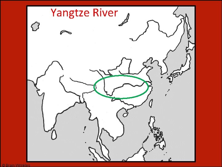
Yangtze • The Yangtze River is China’s longest river and it is located in southeast China. • The Yangtze River basin receives significant rainfall that flows into the river. • Flooding of the Yangtze River keeps the region’s soil fertile (25% of China’s farmland is located here). © Brain Wrinkles

© Brain Wrinkles

Yangtze • The Yangtze River allows ships to transport people and goods from around the world to China’s inland cities. • Many of China’s cities are located along the Yangtze River. • Shanghai, with a population of 22 million people, is located here. © Brain Wrinkles

Shanghai and the Yangtze River © Brain Wrinkles

Ganges • The Ganges River starts on a glacier high in the Himalayan Mountains and winds 1500 miles through India and Bangladesh. • It is the most highly populated river basin in the world, with over 1, 000 people per square mile. • The river is considered sacred by the Hindu religion and is worshipped as the goddess Ganga. © Brain Wrinkles

© Brain Wrinkles

Ganges • The Ganges River is the most important river in the Indian subcontinent. • Indians use the Ganges for irrigation, drinking water, fishing, and for manufacturing needs. • Ships carry agricultural goods down the Ganges River. • Delhi, one of India’s most populated cities with 11 million people, is located along the Ganges. © Brain Wrinkles

© Brain Wrinkles

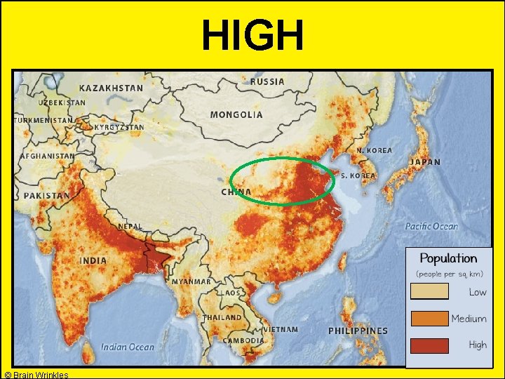
TEACHER INFO: Population Density Review Game • Project the SE Asia Population Density Review directions onto the screen. • The students will look at the feature on the screen and silently hold up the sign language symbol for H (high) or L (low) depending on the correct answer. *Practice first. • After each answer is shown, call on different students to explain. The important thing is that they can explain why the feature has a low/high population (climate, location, available resources, etc. ) © Brain Wrinkles

Directions • Look at each of the features that will be shown on the screen. Based on what you have learned in this lesson, decide if the feature shown has a high population density or a low one. • Depending on the correct answer, hold up the Sign Language symbol for H (high) or L (low). © Brain Wrinkles

Himalayan Mountains © Brain Wrinkles

LOW © Brain Wrinkles

Ganges River © Brain Wrinkles

HIGH © Brain Wrinkles

Gobi Desert © Brain Wrinkles

LOW © Brain Wrinkles

Tibetan Plateau © Brain Wrinkles

LOW © Brain Wrinkles

Huang He River © Brain Wrinkles

HIGH © Brain Wrinkles

SE Asia’s Coastlines © Brain Wrinkles

HIGH © Brain Wrinkles

Taklimakan Desert © Brain Wrinkles

LOW © Brain Wrinkles

Yangtze River © Brain Wrinkles

HIGH © Brain Wrinkles

Thank You! Thank you so much for downloading this file. I sincerely hope you find it helpful and that your students learn a lot from it! I look forward to reading your feedback in my store. If you like this file, you might want to check out some of my other products that teach social studies topics in creative, engaging, and hands-on ways. Best wishes, Ansley at Brain Wrinkles
 Southern and eastern asia map
 Se asia's geography cloze notes 1
 South asia physical features
 Southern & eastern asia physical features map
 Brain wrinkles southern and eastern asia
 Brain wrinkles southern and eastern asia
 Se asia's belief systems cloze notes 1 answer key
 Physical features of southern and eastern asia
 Physical features of southern and eastern asia
 Tea supplemental aids
 Pictorial models of geometric figures with no labels
 Tea supplemental aids
 Hierarchical topical organizer
 Mcas accommodations codes
 Time sequence pattern organizer examples
 Pictorial models of geometric figures
 Marzano graphic organizers
 Mcas accessibility and accommodations
 Graphic weight meaning
 Ghost graphic story graphic and wayfinding
 How did the polos affect trade with asia
 Skimming organizer
 Narrative advance organizers
 Expository advance organizers examples
 Dear organizers
 Discourse analysis and vocabulary
 Marzano nine essential instructional strategies
 Cues questions and advance organizers
 Cues questions and advance organizers
 Chapter 4 section 1 population dynamics answer key
 Section 1 population dynamics
 Population ecology section 1 population dynamics
 Chapter 4 section 1 population dynamics answer key
 Trade diversion and trade creation
 Umich
Umich Which is the most enduring free trade area in the world?
 The trade in the trade-to-gdp ratio
 Fair trade not free trade
 Trade diversion and trade creation
 Tramp liner
 Triangular trade video
 Diameters of fetal head
 Leopold maneuver
 Eastern front line ww1
 Freemasony
 Mbulelo cabuko
 Eastern woodlands landforms
 What happened after rome fell
 Kentucky blue skin people
 Eastern star signs and grips
 Pompey's eastern settlement
 Eastern woodlands homes
 Aerophone
 Northern hemisphere latitude
 Central eastern italy
 Far eastern art
 Ussr control over eastern europe igcse
 What is considered eastern europe
 Chapter 16 eastern mediterranean answers
 Honor flight oregon
 Eastern woodland tribes
 Eastern woodland shelter
 Eastern philosophy
 Eastern kentucky flights
 Differences between western and eastern europe
 Eastern european cuisine
 Western religion vs eastern religion
 Eastern hemisphere oceans
 Western values vs eastern values
 Lesson 1 physical geography of the russian core
 Roman catholic vs eastern orthodox
 Blue people eastern kentucky
 Eastern front 1942 map
 No limits eastern shore
 University of eastern colorado firewatch
 Eastern europe landforms
 Eastern woodland location
 Physical feature of india
 Where did the kwakiutl live
 Human geography of eastern europe
 High school grading scale
 East pacific oscillation
 Federal republic
 Travelers went through the khyber pass to cross the
 London and north eastern railway v berriman
 The beginnings of our global age europe africa and asia
