SOUTHEAST ASIAS GEOGRAPHY Geography Asia is the worlds


: • The Huang He, or Yellow River, begins in the")
 River Continued: • The Chang Jiang is extremely important for China")

 empties into the Yellow Sea.")


- Slides: 9
SOUTHEAST ASIA’S GEOGRAPHY
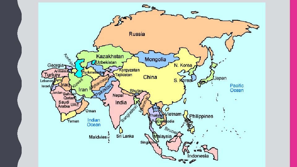
Geography: • Asia is the world’s largest continent with a total land area of more than 17 million square miles. • More than 4 billion people live in Southern and Eastern Asia, with over half of that number living in China and India alone. • The continent has a wide variety of physical features, including deserts, peninsulas, and the world’s highest mountains. Ganges River: • The Ganges River starts in the Himalayas and flows southeast through India and Bangladesh for more than 1, 500 miles to the Indian Ocean. • The name comes from a Hindu goddess and the river is considered sacred to the Hindu religion. • It is the most important river to the Indian subcontinent. • The river runs through India’s most fertile farmland densely populated areas. • Because so many people live and work along the Ganges, the water in the river is heavily polluted.
Huang He (Yellow River): • The Huang He, or Yellow River, begins in the mountainous plateau of Tibet and flows east to the Yellow Sea. • This is China’s second-longest river. • Chinese civilization began in the central area of this river basin. • The river is named for the muddy yellow silt that it carries along its path to the Yellow Sea. • The silt creates rich topsoil for farmers; however, annual floods make the river’s path dangerous. • It’s nickname is “China’s Sorrow” because of the frequent flooding. Chang Jiang (Yangtze) River: • The Chang Jiang (Yangtze) River begins in the Tibetan Plateau and travels east until it reaches the East China Sea. • It’s the largest and longest river in China (over 3, 400 miles) and the third-longest in the • world. • The Chang Jiang empties into the Pacific Ocean.
Chang Jiang (Yangtze) River Continued: • The Chang Jiang is extremely important for China because it provides hydroelectric power, water for irrigation, and transportation for cargo ships. • The Chang Jiang and Huang He Rivers are connected by one of the world’s oldest canal systems, the Grand Canal. • Some parts were built over 2, 000 years ago. Bay of Bengal: • The Bay of Bengal is an extension of the Indian Ocean. • The Bay of Bengal touches India on its west and Myanmar on its east. • The Ganges and many other large rivers flow into this bay. Indian Ocean: • The Indian Ocean is the third largest of Earth’s five oceans. • It is located between Africa to the west, Asia to the north, and Australia to the east.
Sea of Japan: • The Sea of Japan is a small sea that is bound by Russia to the north, the Korean Peninsula to the west, and Japan to the east. • It is an arm of the Pacific Ocean that lies between the Asian continent and Japan. • The sea has large deposits of mineral resources and abundant fish, both of which are important to Japan’s economy. South China Sea: • The South China sea is located between Vietnam and the Philippines. • The South China Sea connects the Pacific and Indian oceans, so many of the world’s international shipping channels run through it. • There are often violent monsoons and typhoons in this region. Yellow Sea: • The Yellow Sea is an extension of the Pacific Ocean that lies between China and the Korean Peninsula.
Yellow Sea Continued: • The Huang He (Yellow River) empties into the Yellow Sea. • It becomes the East China Sea south of the Korean Peninsula. • The Yellow Sea is well-known for its fishing industry. • Unfortunately, in recent years, many species of fish have declined in the Yellow Sea due to overfishing by some countries. Gobi Desert: • The Gobi Desert is Asia’s largest desert. • It expands across southern Mongolia and northern China. • Much of the Gobi Desert is covered with sand bare rock that is exposed by powerful winds blowing across the region. • The Gobi Desert is known as “Shamo”, the Chinese word for “sand desert”. • It can be one of the hottest and also one of the coldest places on earth.
Taklimakan Desert: • The Taklimakan Desert lies between two rugged mountain ranges in northwestern China. • It is over 600 miles in length, making it one of the longest deserts in the world. • Giant sand dunes cover 85% of its surface. • The Taklimakan Desert receives very little annual precipitation. • The plant and animal life in this desert have had to adapt to the dry environment in order to survive. Himalayan Mountains: • The Himalayas lie along the northern edge of the Indian subcontinent and the southern border of China. • They form the natural border between India and China. • The mountains stretch for about 200 miles. • The Himalayan mountain range is the world’s highest mountain region. • It is sometimes called “the roof of the world” because of the area’s high altitudes. • Nine of the world’s ten largest peaks are located here.
Korean Peninsula: • The Korean Peninsula is a mountainous peninsula that juts out of northeastern China in between the Yellow Sea and the Sea of Japan. • Over half of the peninsula is made up of mountains, but there is still plenty of rich farmland. • Since the end of World War II in 1948, the peninsula has been divided into two countries: North Korea (communist) and South Korea (democratic).