South Asia Geography Part Two Plains Valleys Plains


, Gupta (4 th")


 rise abruptly on")
")


![The Himalayas § “him” [snow] § “aalaya” [home] § Mt. Everest is 29, 035](https://slidetodoc.com/presentation_image_h2/40082b80252da82317887b4c92910da6/image-35.jpg "The Himalayas § “him” [snow] § “aalaya” [home] § Mt. Everest is 29, 035")


 • Twin Escarpments in South India")


")


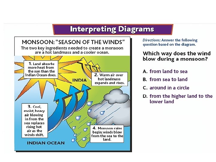
 monsoon drops moisture on the Himalayas before reaching India")
 monsoon carries warm, moist air from the Indian Ocean and")


, Indian industries emphasized")
 and Jamshedpur form an emerging industrial region in")
Ahmadabad: This Maharashtra, Gujarat area specializes in cotton")


- Slides: 112
South Asia Geography Part Two
Plains
Valleys / Plains Indo-G angeti c Plain
Physical Geography Two great rivers - the Ganges and Indus – rise in the mountains and drain Indo-Gangetic Plain
Northern or Indo-Gangetic Plain • Sedimentary covers: The riverine plains of the Indus, the Ganges (known as Ganga to Indians), and the Brahmaputra and the coastal plains of the Indian Peninsula form this region. – The North Indian Plain forms a belt of alluvial lowlands stretching from Pakistan’s Indus River on the west to the Brahmaputra on the east. – The Ganges River with its various tributaries is the major river of northern India. – This region of plains is from 320 to 500 km (200 to 300 mi) wide and it extends through Pakistan, India, and Bangladesh. – The climate varies from arid in Punjab to tropical around the Bay of Bengal. – Soils (inceptisols) are derived from alluvium and they are relatively fertile and generally level. – In the arid areas, irrigation has created environmental problems through accumulation of salts (salinization).
Northern Plain • Fertile region due to Indus, Ganges, and Brahmaputra Rivers • Carry melting snow from mountains to the plains making agriculture possible • Rivers are sacred to Indian people
The Northern or Ganges Plain • One of the most productive regions in Asia – Deep, rich soils • Main Crops: Grains, sugarcane, cotton and oilseeds • River provides irrigation water during dry season • One of the world’s most densely populated regions • Main cities of India are located on or near Ganges
Coastal Plains • Small rivers and seasonal rains provide area with water for farming • Eastern and Western Ghats
Physical Geography Narrow coastal plains lie along the Arabian Sea and the Bay of Bengal
Physical Geography The peoples of these coastal plains became sea traders
• • Indo- Gangetic plain Area that surrounds the Ganges and Brahmaputra rivers Best farmland in India – No coincidence that this is one of the two most densely populated areas in India • They farm rice, wheat, cotton, sugarcane, and tea
Indo-Gangetic Plain • Made up a large fertile flood plain the Northern India and present day Pakistan • Seasonal monsoon rains brought predictable floods to the river systems • Annual floods brought rich deposits of soil over a wide area
Indo-Gangetic Plain • Indo-Gangetic Plain stretches from Indus valley of Pakistan to lower Gangetic delta of Bangladesh • Two regions within the plain • West- Indus Valley- Punjab and Hariyana • East beyond the Delhi Ridge stretching up to Bangladesh • This alluvial plain constitutes the heartland of the Indian civilization Prof. Subho Hstory of
Indo-Gangetic Plain • Densely populated region • Centers of Maurya(300 BC), Gupta (4 th Century Ad) Mughal ( 1526 -1707) and the British Empire (1757 -1947) • Major Urban Centers in South Asia • Lahore, Delhi, Banaras, Calcutta and Dacca • Agricultural Heartland of India, Pakistan, Bangladesh.
Farming Begins Along These Rivers • Early cultures used the water resources of the two rivers to irrigate their fields and produce crop surpluses • 2500 BC first cities emerge in this region
Elevation Levels
Mountains
Mountains & Peaks Hin Kh y Pa ber I ss I du Ku Karakoran sh Mts. Hi ma la Mt. Everest ya ▲ s s hat rn G ste We ills H a hy Vind ts a Gh rn e st a E
Physical Geography High mountain ranges cut India off from immigrants and invaders
Mountains of India • Mountainous Rim • Hems in the country • Has not prevented invasions however – Himalayas – Western Ghats – Eastern Ghats – Rainforests in the shadow of the Ghats
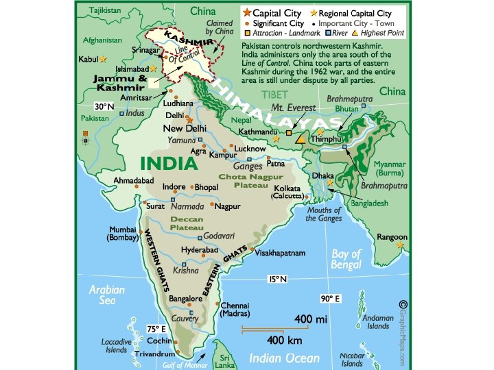
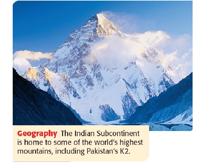
INDIA: Mountains • Alpine system: The Himalayas form a major barrier to the movements of air masses north and south and exceed 6, 096 m (20, 000 ft) in several locations. – Mount Everest (Nepal: Sagarmatha; Tibetan: Chomolungma) is the world’s highest mountain at 8, 848 m (29, 035 ft). – The climate ranges from tropical lowlands to Arctic conditions in the high altitudes of Mount Everest and other peaks. – The Karakoram Pass provides access from north-central India through the Himalayan and Hindu Kush mountains. – The Khyber Pass in the west was used by invading groups. – Population in the Himalayas is limited except in the Vale of Kashmir and in Nepal (25, 200, 000 people). – Bhutan has 900, 000 and Sikkim less than one million. Sikkim has been incorporated into India and is one of its provinces. – Rice and wheat are the dominant grain crops.
Coastal India • The Western and Eastern Ghats: These Ghats (hills) rise abruptly on either side of the Deccan Peninsular. • The Ghats are a barrier to transportation and rainfall. • The narrow coastal plains bordering the Arabian Sea and the Bay of Bengal lie beyond the Ghats. • The Western Coastal Plain is much narrower than the Eastern Coastal plain and much wetter. • Part of ancient maritime empires and well connected with the rest of Asia through trade and commerce. • Thickly populated with flourishing agriculture
Kanchenjunga (India’s highest)
The Northern Mountains • Hindu Kush – Named for their danger • – – Kush= Death Extremely rugged Like the Himalayas are a source of water for much needed rivers
Hindu Kush
The Khyber Pass
The Indian Subcontinent • India is apart of a larger piece of land called the Indian “Subcontinent” – – • A landmass that is part of a continent but is geographically an independent entity India is separated from Asia by the Himalaya and Hindu Kush Mountains The Indian subcontinent is divided into three major physical regions – – – The Northern Mountains The Indo- Gangetic Plain The Deccan Plateau
The Northern Mountains • Himalayan Mountains – Tallest mountain range in the world • 20 mountains that are over 24, 000 ft. high – Mount Everest • Tallest peak at 29, 035 ft – – First climbed by Edmond Hilary & Tenzing Norgay in 1953 Many have tried to climb it since and hundreds have died – Creates the majority of the northern border of India – Source of important rivers to India • Ganges, Feni, Indus, and Brahmaputra rivers
The Himalayas • The colossal Himalayan Mountains form a border between the Indian subcontinent and the rest of Asia. • The Himalayas are the world's tallest mountains, towering more than five miles above sea level. • Himalaya means "home of snow" because the tallest peaks of the Himalayas are always covered with snow.
Himalaya • Himalaya means abode of snow • The largest and highest mountain system in Asia, forming a broad continuous arc for nearly 2600 km (1600 mi) along the northern fringes of the Indian subcontinent, • The Himalayas range, averaging 320 to 400 km (200 to 250 mi) in width, rises sharply from the Gangetic Plain. • North of this mountain belt lies the Tibetan Plateau (Qing Zang Gaoyuan). • Origins of snow fed river systems and movements of monsoon • Dividing line between India and the rest of north Asia
The Himalayas • The Himalayas include Mount Everest, the tallest mountain in the world. • Everest rises 29, 028 feet above sea level on the border between Nepal and China. • No plant life grows near the mountain's peak due to powerful winds, extremely cold temperatures, and a lack of oxygen.
The Himalayas • Many adventurous people attempt to climb Everest every year • Often their venture ends in sickness or death. Most people are unable to breathe 20, 000 feet above sea level because there is not enough oxygen in the atmosphere. • A person will suffer brain damage when they are unable to breathe. • Strong winds and frigid temperatures make the climate even more rigorous. • Clearly the peak of Mount Everest is a place for only the heartiest of people.
The Himalayas § “him” [snow] § “aalaya” [home] § Mt. Everest is 29, 035 feet. It is the highest mt. peak in the world.
Himalaya as Civilization • • • Himalaya in Hindu legend Abode of Shiva and Durga The Great Himalayas, (the highest zone, consists of a huge line of snowy peaks with an average height exceeding 6100 m (20, 000 ft). The width of this zone is about 24 km. The Middle Himalayas (also known as the Inner or Lesser Himalayas), (average height between 6000 and 10, 000 ft, width of about 80 km ). the Sub-Himalayas, which includes the Siwalik Range and foothills and the Tarai and Duars piedmont (an area of land formed or lying at the foot of a mountain or mountain range) (width of 48 km). Residence of 40 million people Densely populated valleys English hill stations Sparsely populated forests and natural resources Diversity of population Muslim, Hindus, Buddhists, Christians
The Himalayas
More MOUNTAINS • Eastern and Western Ghats (India) • Twin Escarpments in South India – “V” shaped. http: //www. tamilnadutourism. org/geo. htm
Influence of Mountains: • Population & Settlements -lower elevations have higher populations • Movement -Khyber Pass – “gateway for invasions” • Climate -block cold air from the North
Earthquake Zones in India
2004 Earthquake In Indonesia: Tsunami Devastates Indian Ocean Coastlines!
the Tsunami’s Devastation 100, 000 s dead!
Plateaus and Deserts
Deserts / Plateaus Tibetan Plateau r Tha t er s e D Deccan Plateau
Deccan Plateau • Gondwana Shield: This landform region extends southward from the southern borders of the Ganges drainage area and includes the lava covered Deccan Plateau. – This plateau is framed on the north by the Vindhyas and the Tapti and Godavari Rivers; on the west, the Western Ghats (Hills) lining the Malabar Coast; on the east, the Eastern Ghats paralleling the Coromandel Coast; at the southern margin are the Blue Mountains which exceed 2, 600 m (8, 800 ft). – The central portion of the Deccan Plateau has fertile soils (vertisols), derived from volcanic materials, primarily cultivated with cotton. – Elevations of the Deccan Plateau are approximately 305 to 450 m (1, 000 to 1, 500 ft). – The coastal areas have a humid tropical climate with abundant rain from the orographic effect of the Ghats.
Deccan Plateau • The Deccan lies south of these two river valleys. • It is a hilly and dry plateau extending from the southern Ganges valley to the southern end of India
Deccan • Triangular plateau- raised level of land • Most of area is arid, unproductive, and sparsely populated
Peninsular India Deccan Plateau • This plateau occupies the greatest part of India - a tilted tableland of low rolling hills, great river valleys and uplands. • In the central area, the rich black soil retains water but in the regions where this soil does not occur water is a constant problem. • Much of India's mineral wealth is found on the plateau. • The southern part of the plateau is called the Deccan Peninsular. • The Dec ' can tilts to the east, declining in elevation and containing river systems which form fertile deltas when they reach the Bay of Bengal.
The Deccan Plateau § 31, 800 square miles in size. § Elevation range: 2, 000 – 8, 000 feet high. § From the Sanskrit word, “dakshina” [“the south”].
The tibetan Plateau § The “Roof of the World. ” § average elevation is 16, 400 feet.
The Thar Desert § The Great Indian Desert § 200 - 1500 feet in elevation. § up to 127ºF in July.
Other Kashmir Punjab
Hi Completed Map nd Kh y Pa ber I ss I u. Ksarakoran h Mts. Tibetan Kashmir Plateau. Mt. Ev Hi R erest m Punjab s a B r a h maputra R. lay du Indo-Gang n a etic I s ▲ P l a i G n r a a n ges R Th t. r e s e D lls i H hya d n i V ts a Bay of h Deccan G Bengal n Plateau er st Arabian Sea a E s hat rn G ste We Indian Ocean
Drass -450 C in December night Tawang 190 C in June 550 C temperature in June Thar desert Diurnal range of temperature 300 C Jaisalmer receives 9 cm rainfall Tiruvanantapuram & Chennai 200 C in December night Cherrapunji & Mawsynram have 1080 cm rain Kerala Diurnal range of temperature 80 C MONSOON REGIME IS THE UNITY OF INDIA
The Indian Subcontinent has a great variety of climate regions and resources. The Indian Subcontinent has four climate regions: the highland climate, the subtropical climate, the tropical climate, and the desert or steppe climate. Monsoons have a huge influence on the weather and climates in the subcontinent. Agricultural and mineral resources are plentiful.
Climate Regions 1. Highland climate – Himalayas – Brings cool temperatures to much of Nepal and Bhutan 2. Humid subtropical climate – Plains south of the Himalayas – Hot, humid summers with plenty of rainfall 3. Tropical climate – Covers much of the subcontinent – Tropical savanna in central India and Sri Lanka – Humid tropical climate in southwest India, Sri Lanka, Maldives, and Bangladesh 4. Desert and steppe climate – Throughout southern and western India and most of Pakistan – Dry
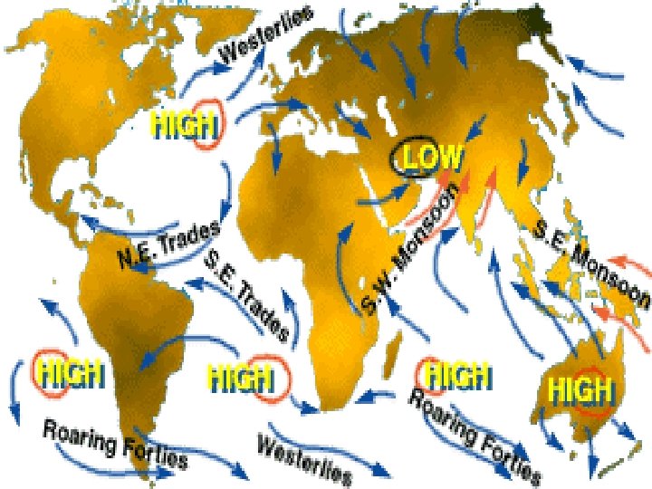
India’s Climate • India's climate is dominated by monsoons. Monsoons are strong, often violent winds that change direction with the season. • Monsoon winds blow from cold to warm regions because cold air takes up more space than warm air. • Monsoons blow from the land toward the sea in winter, and from the sea toward land in the summer.
India’s Climate • India's winters are hot and dry • The monsoon winds blow from the northeast and carry little moisture. • The temperature is high because the Himalayas form a barrier that prevents cold air from passing onto the subcontinent. • Additionally, most of India lies between the Tropic of Cancer and the equator, so the suns rays shine directly on the land. • The temperature can reach as high as 110 degrees Fahrenheit during the Indian winter.
Climate Regions of South Asia
Monsoons
Climate Monsoons - seasonal winds that blow from the NE Nov. to Mar. and from the SW June to Oct.
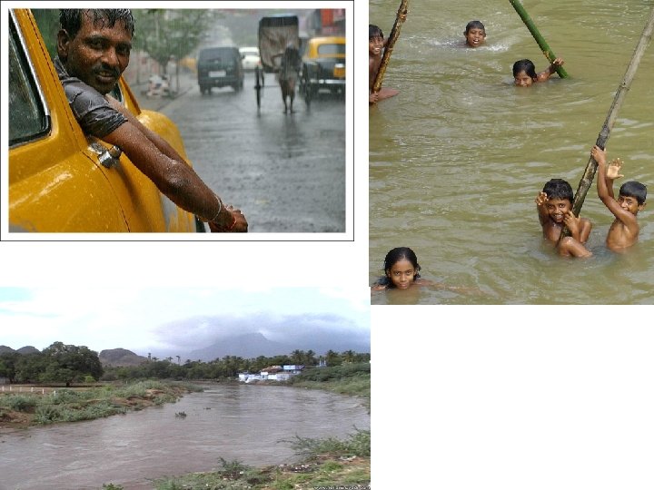
Seasonal winds known as monsoons bring rain every summer. India is dependent upon monsoons to grow their crops. Not enough rain brings drought. When there is too much rain, rivers rise and cause deadly floods and destruction of crops.
What is a Monsoon? • A season of high temperatures, high winds, and high moisture, resulting in potentially deadly weather. • Winds that change direction with the change of season. • Winds blow in response to differences in temperature between air over the land air over the sea. • Widespread torrential rains, and even severe thunderstorms, often accompany the onset of a monsoon.
• A monsoon is a strong wind that blows one direction in winter and the opposite direction in summer. Monsoons bring rain in summer.
Cold season: Dry winds blow from land to ocean Warm season: Wet winds blow from ocean to land transport moisture large rainfall
Water Critical Factor The people of India’s first civilizations depended upon the monsoons to bring the water that their crops needed. Monsoon Rains Devastating Effects • Monsoon rains flooded rivers; rivers deposited fertile silt in which farmers could grow crops • Monsoon rains too heavy— crops, homes, lives could be lost • With abundance of rainfall came threat of devastation • Monsoon rains too late, did not last long enough—people could not grow crops; famine became danger
Why are monsoon rainfalls important? water management, disaster mitigation, agricultural efficiency e. g. ) Asian monsoons About 60% of the world’s population depends on monsoon e. g. ) Asian monsoons (India) • 8. 2 % economic growth in the year ending 2004 March with the help of the good monsoon • 5. 5 -6. 5% in this year’s growth because of the late onset of monsoon last summer. (Asian Development Bank) • Onset, extent and overall amount of monsoon rainfall play a key role
How Do Monsoons Affect Us? • Brings heavy rain in summer • Rain can last for days • Very few breaks may produce floods • Homes, crops, and businesses may be ruined due to flood
How Do Monsoons Affect Us? • If the monsoon season is late it may bring about drought. • Drought effects agricultural output. • A decrease in agriculture is likely to lead to an increase in prices and higher inflation. • Inflation effects our ability to purchase things.
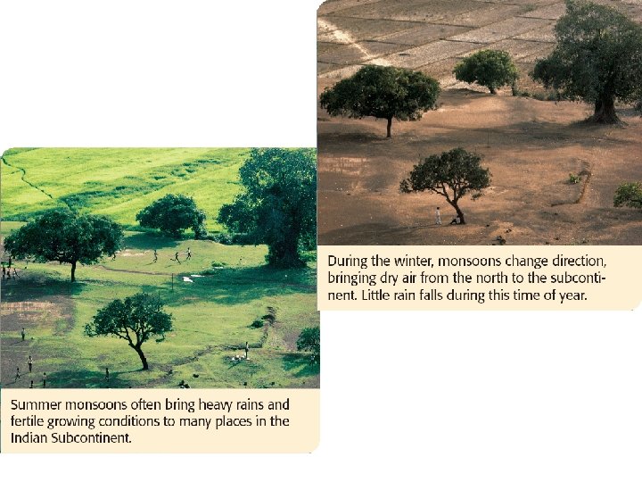
Climate The NE (dry) monsoon drops moisture on the Himalayas before reaching India
Climate The SW (wet) monsoon carries warm, moist air from the Indian Ocean and brings heavy rains
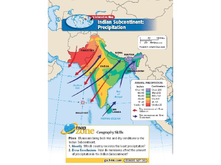
Climate The wet monsoon brings most of the year’s rainfall and is important for agriculture 20 cm = 7. 9 in 100 cm = 39. 4 in 400 cm = 13. 2 ft 800 cm = 26. 3 ft 1000 cm = 32. 8 ft
Climate If the wet monsoon arrives late or brings little rain, crops fail; too much rain, flooding destroys the countryside
Climate Temperatures can reach 120ºF in the Indo. Gangetic Plain Aurangabad, India 15 C = 59 F 30 C = 86 F 45 C = 113 F
December to March ~~~~ Cold April to May ~~~~ Very hot (Often over 100 degrees) June to September ~~~~ Monsoon season October to November ~~~ less rain MONSOONS Monsoons are huge rain storms that come in from the Indian Ocean. They bring enough rain to supply water for the whole year. These storms have strong winds. They can flood and destroy farms and houses. Some have even killed people. Are there storms like these in the United States?
Winter Monsoons: Nov. -April
Summer Monsoons: May-Oct.
Temperature
Agriculture
Major Farming Systems of South Asia
Agriculture Primary Sector: • Indian agriculture is inefficient and labor intensive. • Animals are frequently used for power. • The village is the focus of life for 74 percent of the Indian population with an estimated 580, 000 villages. • Approximately 2/3 of India's huge working population (63 percent) depends directly on the land for its livelihood. • Substantial progress toward modernization has been made in the Punjab's wheat zone. • In the early 1980 s more than 1/4 of India's cultivated area was still owned by only 4 percent of the country's farming families. • Half of all rural families either owned as little as a half hectare (1. 25 acres) or less, or no land at all. • Land consolidation efforts have had only limited success, except in the states of Punjab, Haryana, and Uttar Pradesh.
Agriculture • Major crop zones: 1. Wheat. Dry northwest notably in the Punjab and neighboring areas of the Upper Ganges. Many gains from the Green Revolution through the introduction of high-yielding varieties developed in Mexico. Rice. Moist east and a summer monsoon drenched south. More than 1/4 of all of India's farmland lies under rice cultivation, most of it in the states of Assam, West Bengal, Bihar, Orissa, and eastern Uttar Pradesh. This area has more than 100 cm (40 inches) of rainfall. India has the largest acreage of rice among the world's countries. Yields per hectare still low at below 1, 000 kg (900 lbs. /acre), however. Coconut. Malabar Coast. (Kerala) Millet. Southwestern India. A cereal grass, Setaria italica, extensively cultivated in the East and in southern Europe for its small seed or grain, used as food for man and fowls, but in the U. S. grown chiefly for fodder. Groundnut. Kathiawar Peninsula. Cotton. West-Central India (Deccan Plateau). Chick Peas. Northwest. Plantation. Northeast. 2. 3. 4. 5. 6. 7. 8.
Agriculture • Livestock: • India has more livestock than any other country in the world. – – Cows - 200, 000 water buffalo - 60, 000 Goats and sheep - 60, 000 Horses, donkeys, and elephants - 5, 000 • Sheep are of major importance in the drier west where the Islamic population is clustered. • Water buffalo is dominant in the Ganges Delta and coastal regions. • Cattle (particularly the Brahman or Zebu breeds) are found throughout India.
Agriculture • Cattle are an integral element of the Indian agricultural economy. – They are the primary source of draft power (plowing, pulling carts, grinding grain, and a host of other tasks). – Cattle graze on forage which would otherwise be wasted during a dry season. – Cattle consume secondary agriculture byproducts (straw, rice husks, and corn stalks). – Cattle produce an estimated 771, 000 metric tons (850, 000 tons) of cow dung, the principle source of domestic fuel a year. – Dung is also mixed with mud and used for plaster; also a major source of fertilizer. – Cattle also produce most of India's milk (the bulk of which comes from the water buffalo). – When a cow dies, it is consumed by the untouchables (who have no prohibitions about consuming beef when it is available) of the large Hindu population. – Cow hides are a major source of leather. – The maintenance of the large numbers of cows and buffalo is a completely rational activity in the Indian agricultural economy.
Green Revolution and Impact on Agriculture in India
Agriculture The Green Revolution • Increased yields of food production • India is able to feed itself • Advanced agricultural technology • Applies to DEVELOPING countries
Agriculture • Green Revolution describes the development of extremely highyielding grain crops that allow major increases in food production, particularly in subtropical areas. • In 1953, scientists developed rust-resistant dwarf wheats which doubled Mexico's per acre production in the next decade. • After a major drought in India in 1965, Mexican dwarf wheat was widely planted in the Punjab region, producing dramatic increases in wheat yields. • The improved rice (IR)- IR-8 was spotted in 1965 at the Los Ba. Zos research institute in the Philippines, which was set up using aid from the Ford and Rockefeller Foundations. • Its first harvest, from 60 trial tons of seeds, produced a six-fold increase of rice under field conditions. • About 10% of India's paddy land is now planted with IR-8 varieties.
Agriculture • Green Revolution benefits: – Two to four times the yield of indigenous grains. – A shortened growing season allows two crops per year. – “Miracle grains" have a wider tolerance for climatic variations. • Green Revolution problems – Need for high application of fertilizer and insecticide, and in the case of rice, there is a need for copious irrigation. – "Miracle grains" have been adopted in the most prosperous areas and among the most prosperous farmers. As a result, interregional and social gaps have widened. – Traditional marketing patterns have been upset. Thailand Myanmar (Burma) have found their traditional markets disappearing, and Japan now looks for exports.
Silk Cultivation
Economic Activities & Resources
Industries
Industries • Secondary sector: • At the time of independence (1947), Indian industries emphasized textiles and food processing. • Gandhi championed development of the cottage industries that existed prior to the intervention of Britain. – A cottage industry involves small scale production using high labor inputs. – Cottage industries are very important because they are labor intensive. – They employ 40 individuals for every one employed in a large automated factory producing the same products. – A total of 750 products is produced by small industries which use <=$100, 000 in capital. (Receivers, tools, plumbing fittings, etc. ). • Manufacturing employs only 13% of the labor force.
Industries Manufacturing Regions: 1. Kolkata (Calcutta) and Jamshedpur form an emerging industrial region in northeastern India. – Calcutta forms the center of the Bihar-Bengal area where jute manufacturing dominates, but engineering, chemical and cotton industries also exist. Jute: a strong, coarse fiber used for making burlap, gunny, and cordage; it is obtained from two East Indian plants-Corchorus capsularis and Corchorus olitorius of the linden family. – The Jamshedpur region 240 km (150 mi) west of Calcutta has the Tata Steel Works, India’s single largest steel making complex (Indian Ruhr). – In the nearby Chota-Nagpur district, coal mining and iron and steel manufactures have developed, and Bhilai is a growing nucleus of heavy industry.
Industries Manufacturing Regions: 2. Western Zone-Mumbai (Bombay)Ahmadabad: This Maharashtra, Gujarat area specializes in cotton and chemicals with some engineering and food processing, automobiles, and petrochemicals. 3. Southeastern Zone- Chennai (Madras): specializing in textiles. 4. Bangalore supports diversified electrical manufacturing, machine tools, the construction industry, and food processing.
Natural Resources
Natural Resources Agricultural Resources • Fertile soil • Timber • Livestock Mineral Resources • Iron ore – India • Coal – India • Natural gas reserves – Pakistan • Gemstones – Sri Lanka
INDIA: Natural Resources • India has a rather poor resource base. • The country does not lead the world in any of the important minerals or other sources of energy useful for industrialization and development. • India is the second largest producer of grains. • The possibility for expanding production of grains remains very low, despite gains. • Low productivity person in the agricultural sector accentuate the problems of population, making it difficult to increase production. • India has the largest deposit of high-grade iron ore in the world. In Bihar state alone, a single range is estimated to hold nearly three billion tons of iron ore. • Iron ore deposits are also important in the state of Karnataka. • India produces 5. 6 percent of the world's iron ore and has 6. 6 percent of the world's reserves in iron ore.
Natural Resources • India produces 3. 8 percent of the world's coal. • Coal and steel are produced in the Damodar Valley fields of northeastern India which account for more than 50 percent of coal production. • Limited coking-coal deposits are found in Chota Nagpur. • India has discovered oil deposits in the Bay of Bengal which hold promise for further expansion. • India has a great hydroelectric potential, provided dams are constructed to exploit the rivers of the country. • India has important deposits of uranium; phosphates in the Thar Desert, and manganese (5. 2 percent) in the central Deccan plateau and eastern Coromandel Coast. • India produces 2. 5 percent of the world's bauxite, and it produces 5. 2 percent of the world's chromite.
Languages and Religions
INDIA: CULTURAL GEOGRAPHY • In 1947, the Indian subcontinent had 550 princely states, 900 separate dialects and 15 major languages. • The two major linguistic families are the Indo-European and the Dravidian. • Languages that are members of the Indo-European family are spoken in the central and northern parts of the country, and languages that belong to the Dravidian family are spoken in southern India. • Dravidian languages are spoken by about 25 percent of the Indian population. They include Telugu, Tamil, Kannada, and Malayalam. • Today India has fourteen official languages including Hindi and English (associate official). Hindi is the official and predominant language of India. • Hindi was one of the 14 languages given national status by the Indian constitution, 10 in the north and 4 in the Dravidian south. • Before World War II, the British recognized 179 official languages and 544 dialects (total=723). • English would remain a lingua franca when Hindi could not serve as a medium of communication at government and administrative levels.
Language Families in South Asia
Language in India alone
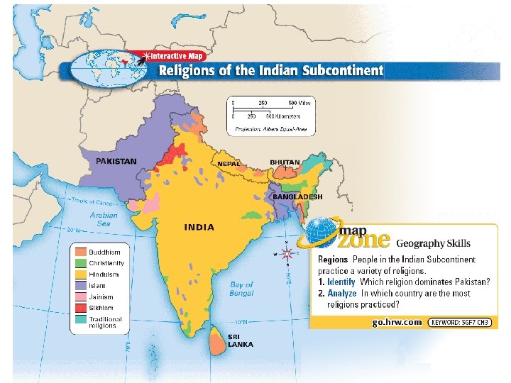
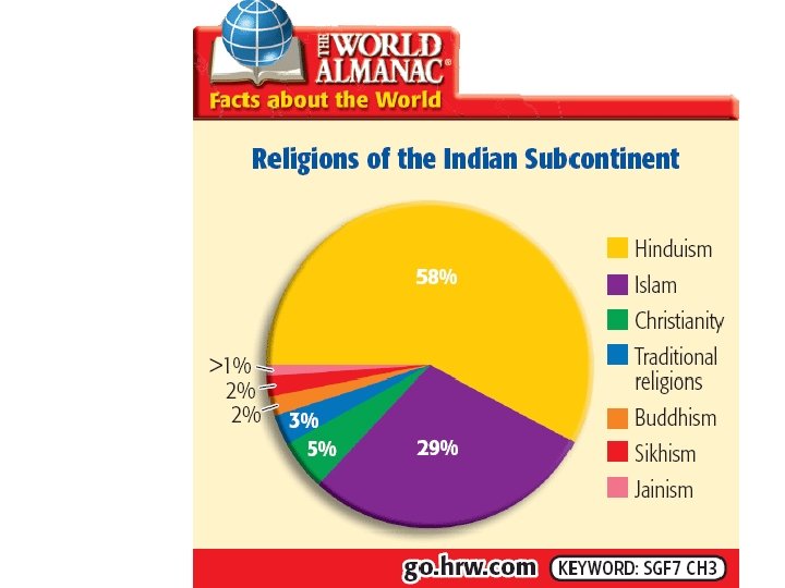
INDIA: CULTURAL GEOGRAPHY • Religions: • Hinduism 81. 3% • Muslim 12. 0% – Sunni 9. 0% – Shiite 3. 0% • Christian 2. 3% – Protestant 1. 1% – Roman Catholic 1. 0% • Sikh 1. 9% • Buddhist 0. 8% • Jain 0. 4% • Zoroastrian 0. 01% • Other 1. 3%