
Some Recent GIS Applications in Transportation and Logistics



- Slides: 27
Some Recent GIS Applications in Transportation and Logistics New York Metropolitan Transportation Council November 19, 2008 Fan Yang City College of New York fyang@ce. ccny. cuny. edu
Outline Introduction to GIS Online Geocoding Methods Web-based GIS solutions GIS in Logistics 2
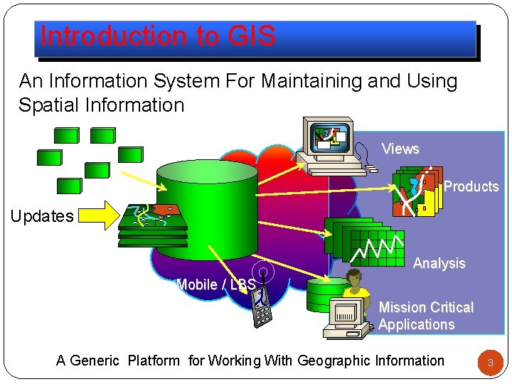
Introduction to GIS An Information System For Maintaining and Using Spatial Information Views Products Updates Analysis Mobile / LBS Mission Critical Applications A Generic Platform for Working With Geographic Information 3
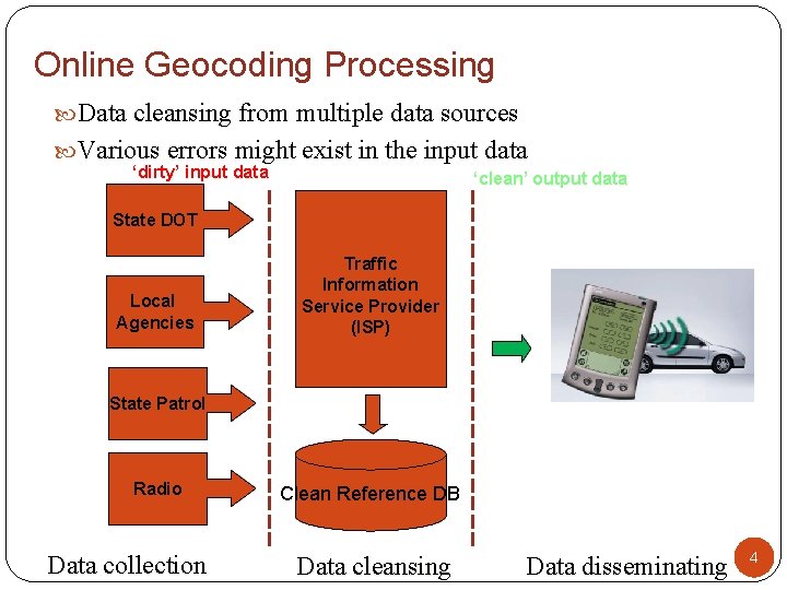
Online Geocoding Processing Data cleansing from multiple data sources Various errors might exist in the input data ‘dirty’ input data ‘clean’ output data State DOT Local Agencies Traffic Information Service Provider (ISP) State Patrol Radio Data collection Clean Reference DB Data cleansing Data disseminating 4
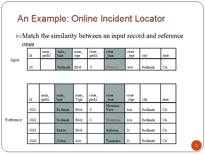
An Example: Online Incident Locator Match the similarity between an input record and reference ones main_ prefix Id main_ base main_ type cross_ prefix cross _base cross _type city state Redlands Blvd S Watman Ave Redlands CA cross_ prefix cross _base cross _type city state Ave Redlands CA Input: 10 Id Reference: main_ prefix main_ base main_ Type 1021 Redlands Blvd S Mountain View 1022 Redlands Blvd S Waterman Ave Redlands CA 1023 Barton Blvd Alabama St Redlands CA 1024 Colton Ave Tennessee St Redlands CA 5
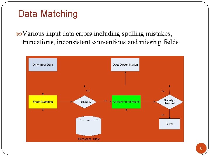
Data Matching Various input data errors including spelling mistakes, truncations, inconsistent conventions and missing fields 6
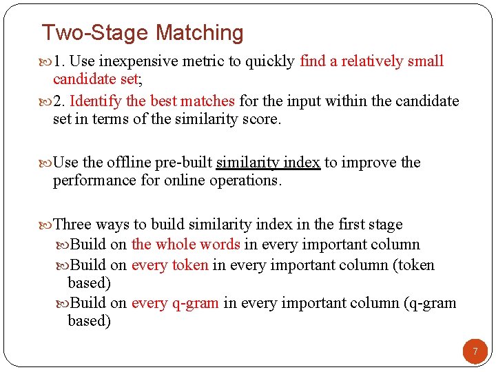
Two-Stage Matching 1. Use inexpensive metric to quickly find a relatively small candidate set; 2. Identify the best matches for the input within the candidate set in terms of the similarity score. Use the offline pre-built similarity index to improve the performance for online operations. Three ways to build similarity index in the first stage Build on the whole words in every important column Build on every token in every important column (token based) Build on every q-gram in every important column (q-gram based) 7
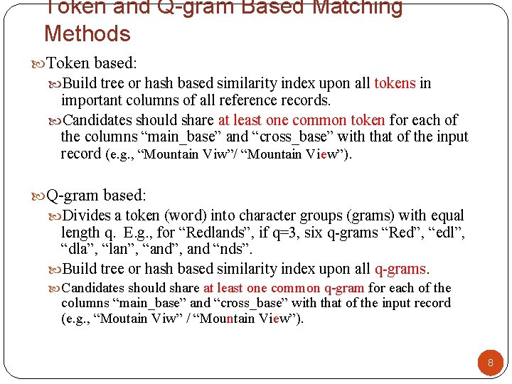
Token and Q-gram Based Matching Methods Token based: Build tree or hash based similarity index upon all tokens in important columns of all reference records. Candidates should share at least one common token for each of the columns “main_base” and “cross_base” with that of the input record (e. g. , “Mountain Viw”/ “Mountain View”). Q-gram based: Divides a token (word) into character groups (grams) with equal length q. E. g. , for “Redlands”, if q=3, six q-grams “Red”, “edl”, “dla”, “lan”, “and”, and “nds”. Build tree or hash based similarity index upon all q-grams. Candidates should share at least one common q-gram for each of the columns “main_base” and “cross_base” with that of the input record (e. g. , “Moutain Viw” / “Mountain View”). 8
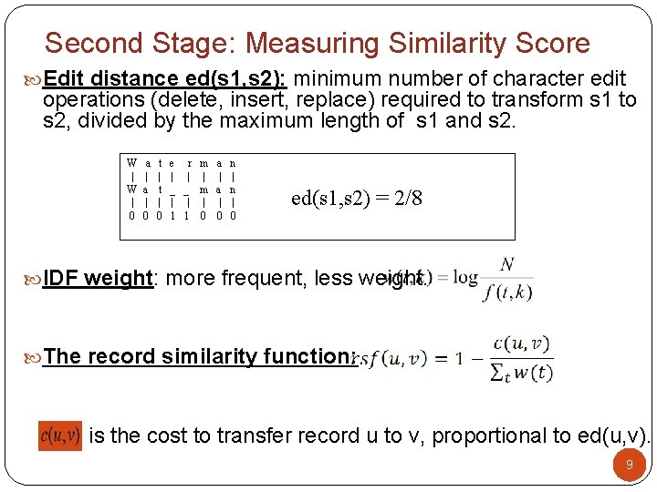
Second Stage: Measuring Similarity Score Edit distance ed(s 1, s 2): minimum number of character edit operations (delete, insert, replace) required to transform s 1 to s 2, divided by the maximum length of s 1 and s 2. W a t e r m a n | | | | | | W a t _ _ m a n | | | | | | 0 0 0 1 1 0 0 0 ed(s 1, s 2) = 2/8 IDF weight: more frequent, less weight. The record similarity function: is the cost to transfer record u to v, proportional to ed(u, v). 9
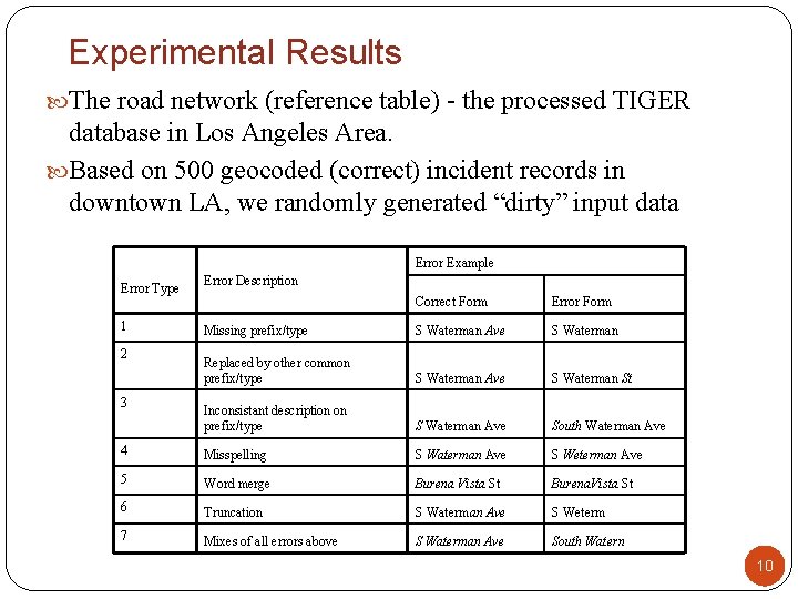
Experimental Results The road network (reference table) - the processed TIGER database in Los Angeles Area. Based on 500 geocoded (correct) incident records in downtown LA, we randomly generated “dirty” input data Error Example Error Type Error Description Correct Form Error Form Missing prefix/type S Waterman Ave S Waterman Replaced by other common prefix/type S Waterman Ave S Waterman St Inconsistant description on prefix/type S Waterman Ave South Waterman Ave 4 Misspelling S Waterman Ave S Weterman Ave 5 Word merge Burena Vista St Burena. Vista St 6 Truncation S Waterman Ave S Weterm 7 Mixes of all errors above S Waterman Ave South Watern 1 2 3 10
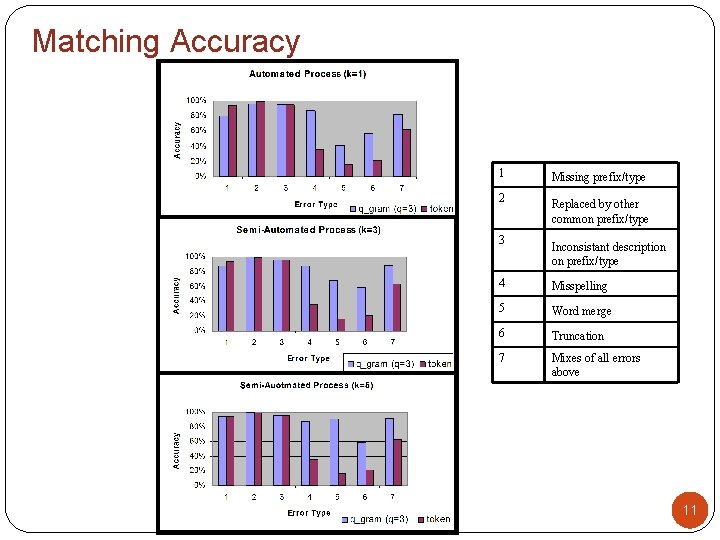
Matching Accuracy 1 Missing prefix/type 2 Replaced by other common prefix/type 3 Inconsistant description on prefix/type 4 Misspelling 5 Word merge 6 Truncation 7 Mixes of all errors above 11
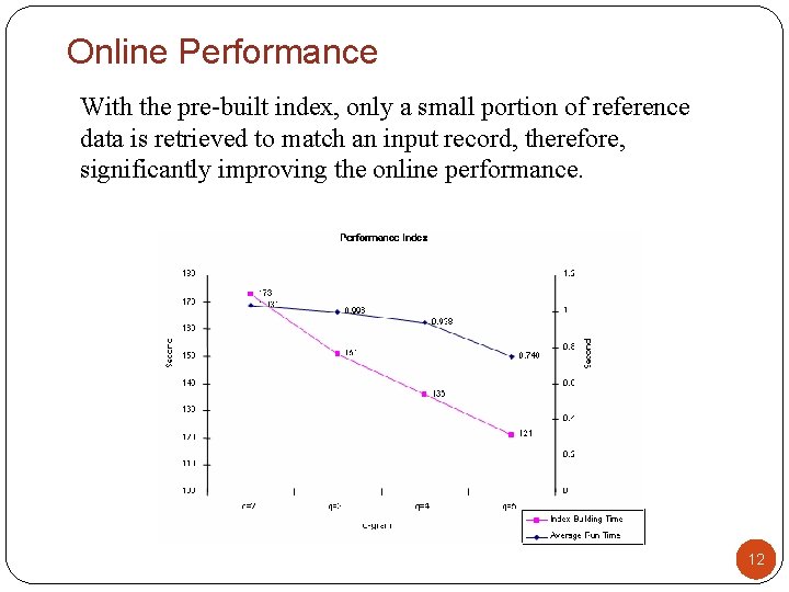
Online Performance With the pre-built index, only a small portion of reference data is retrieved to match an input record, therefore, significantly improving the online performance. 12
The Size of the Candidate Set The smaller q value means finer granularity, and may catch more candidates which might be missed for larger q values. The size of the candidate set increases as q value becomes smaller. 13
Remarks Proposed two efficient approximated matching methods for online incident data cleansing. A two-stage matching procedure is developed to significantly improve the online performance. The q-gram based method outperforms the token based one in terms of match accuracy. Suggest q=3. This study can be applied to ITS online data management such as loop detector data and construction data. More geographical information can be accommodated. 14
Outline Introduction to GIS Online Geocoding Methods Web-based GIS solutions GIS in Logistics 15
Why Web-based GIS Solutions Consume fewer licenses and require thinner client. Provide rich spatial analysis and editing functionalities. Satisfy service Oriented Architecture (SOA) Provide SOAP (Simple Object Access Protocol), WMS (Web Map Service), KML(Keyhole Markup Language) based services. 16
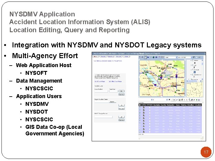
NYSDMV Application Accident Location Information System (ALIS) Location Editing, Query and Reporting • Integration with NYSDMV and NYSDOT Legacy systems • Multi-Agency Effort – Web Application Host • NYSOFT – Data Management • NYSCSCIC – Application Users • NYSDMV • NYSDOT • NYSCSCIC • GIS Data Co-op (Local Government Agencies) 17
ALIS: Web-based GIS Application Automatically verifies the location information against the GIS basemap Allows users to edit or update accident locations based on the availability of improved map data in a region or the availability of more information pertaining to the accident case. Allows users to monitor and record changes made to the geospatial database. Provides users the ability to select street segments for editing using either spatial queries, attribute queries, or network tracing. 18
Outline Introduction to GIS Online Geocoding Methods Web-based GIS solutions GIS in Logistics 19
What is “GIS Logistics”? “Using advanced Geographic Information Systems (GIS) tools and methods in conjunction with existing infrastructure and procedures in order to solve logistics problems” Main Applications: • Site Selection Analysis • Asset and Property Management • Territory Optimization • Real-time Dynamic Routing and Scheduling • Supply Chain Management 20
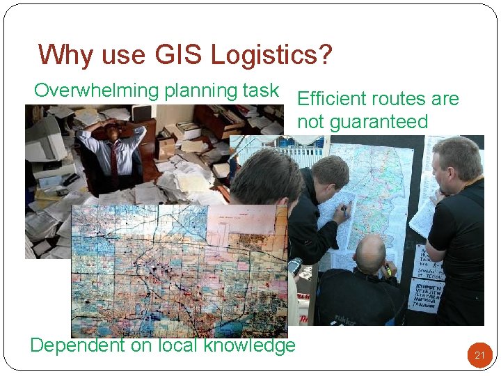
Why use GIS Logistics? Overwhelming planning task Efficient routes are not guaranteed Dependent on local knowledge 21
What is Territory Optimization? A periodic vehicle routing solution in a big territory Distribute periodic orders among available trucks/drivers Input: service requests, truck schedules, and business rules Output: truck daily schedule Large-scale problem size and complicated business rules The goal Balance workloads among employees Minimize total travel time (by all trucks over the entire planning period) Minimize time window violation Minimize overtime 22
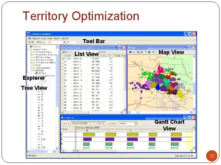
Territory Optimization Tool Bar List View Map View Explorer Tree View Gantt Chart View 23
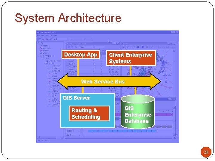
System Architecture Desktop App Client Enterprise Systems Web Service Bus GIS Server Routing & Scheduling GIS Enterprise Database 24
What is Real-time Dynamic Routing and Scheduling? Customers call for periodic service requests Used to determine optimal truck schedule candidates Need to be served in a real-time fashion Might change the existing daily schedule 25
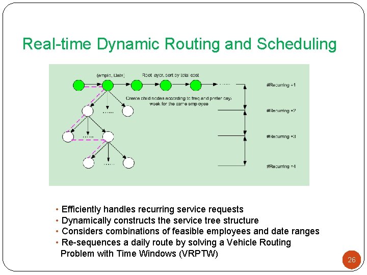
Real-time Dynamic Routing and Scheduling • Efficiently handles recurring service requests • Dynamically constructs the service tree structure • Considers combinations of feasible employees and date ranges • Re-sequences a daily route by solving a Vehicle Routing Problem with Time Windows (VRPTW) 26
Thank you! Questions? 27