Soil formation begins with weathering of bedrock http

Soil formation begins with weathering of bedrock http: //images. encarta. msn. com/xrefmedia/aencmed/targets/illus/ilt/T 045308 A. gif
![Factors Influencing Soil Formation (Ch 2) v Parent material (geological [~inorganic] and organic precursor)](http://slidetodoc.com/presentation_image/086b76fe400a97dbb58d8ebdad4633a5/image-2.jpg "Factors Influencing Soil Formation (Ch 2) v Parent material (geological [~inorganic] and organic precursor)")
Factors Influencing Soil Formation (Ch 2) v Parent material (geological [~inorganic] and organic precursor) v Climate (temperature, precipitation) v Biota (vegetation, microorganisms, earthworms, humans) v Topography (slope, aspect, landscape position) v Time (period since formation began) ~ if all the soil forming factors are the same, then will similar soils be formed in different locations? Brady and Weil, 2004

Four basic processes of soil formation Ø Additions: organic matter input, soil from wind erosion… Ø Losses: leaching, erosion Ø Transformations: weathering of primary particles Ø Translocations: movement of inorganic and organic material

Classification Order Suborder Great group Subgroup Family http: //grunwald. ifas. ufl. edu/Nat_resources/soil_forming_factors/formation. gif

Soil Classification and Taxonomy A system to describe and classify soils Based on properties of soils observed in the field Includes diagnostic surface horizons (epipedons) and subsurface horizons, moisture and temperature regimes, and other properties.

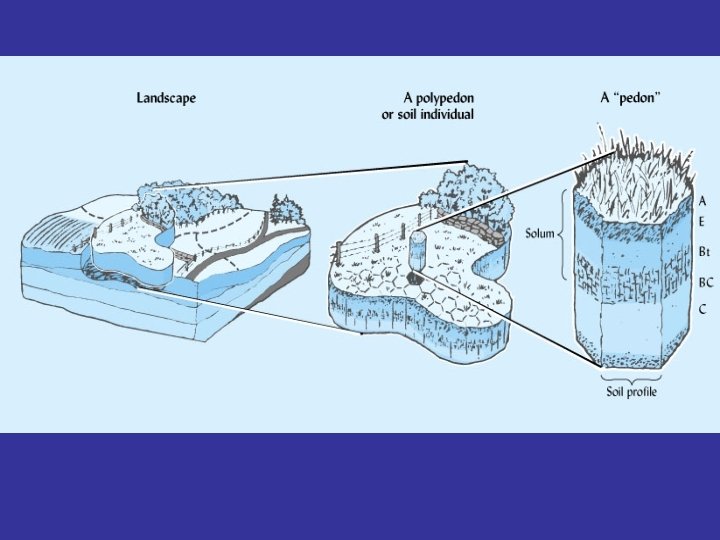
Soil Classification Pedon: the smallest volume of soil that displays the full range of characteristic soil properties (or lateral dimensions large enough to permit the study of horizons) Area ranges from 1 to 10 m 2 A group of similar pedons is known as a polypedon Several pedons or polypedons having similar soil profile properties and horizons are classified as a soil series Brady and Weil, 2004

Soil Taxonomy Comprehensive soil classification system System is based on measured or observed soil properties Ø Surface and subsurface diagnostic horizons Ø Moisture and temperature regime Ø Color, texture, structure Ø Organic matter, clay, iron, aluminum oxides, silicate clays, salts, p. H, base saturation Ø Soil depth

Epipedons: Surface horizon Epi- over; pedon- soil Forms near the soil surface and can include B-horizon Ø Mollic (dark color, thick, soft, usually developed under grass) Ø Umbric (similar to mollic, low base saturation, high rainfall area, parent material has lower Ca, Mg) Ø Ochric (thin, light colored, low in OM, hard and massive when dry) Ø Melanic (black, organic matter rich, developed from volcanic ash) Ø Histic (OM overlying mineral soil, formed in wet areas, black to dark brown peat or muck with low bulk density) Brady and Weil, 2004

Fig 3. 3 Pg. 62 18 subsurface horizons

Diagnostic horizons are based on the presence of materials and their properties

Note some common horizons in arid and semi-arid regions due to low leaching
 Ø Argillic (clay accumulation: coatings,")
“commonly encountered” Diagnostic horizons below the soil surface (subsurface) Ø Argillic (clay accumulation: coatings, bridges, shiny skins) Ø Natric (clay accumulation plus 15% ESP) Ø Kandic (Fe, Al oxides and low activity silicate clays) Ø Oxic (highly weathered, high in Fe, Al oxides, kaolinite; not sticky even though it contains clay) Ø Spodic (accumulation of colloidal organic matter and Al oxide; found in highly leached forest soil in cool humid areas) Ø Albic (light colored; low in clay and Al, Fe oxides) Ø Calcic (carbonates), Gypsic (gypsum), Salic (salts), or Petrocalcic, petrogypsic if cemented

Five Soil Moisture Regimes • Refers to the presence or absence of water – affects plant growth, leaching, weathering, soil development, land use, … • Related to climate (mostly precipitation and temperature) • Timing and amount of rainfall is important – More weathering and soil development during summer rains than winter rains

Five Soil Moisture Regimes • Aquic – waterlogged conditions which cause gleying and mottles • Udic – high moisture (no plant stress, excessive leaching of soil profile) • Ustic – some plant available water, but also periods of drought • Aridic – dry conditions, salt build-up, slow plant growth, low OM • Xeric – cool, moist winters and warm, dry summers with drought (Mediterranean climate)
 Permafrost present")
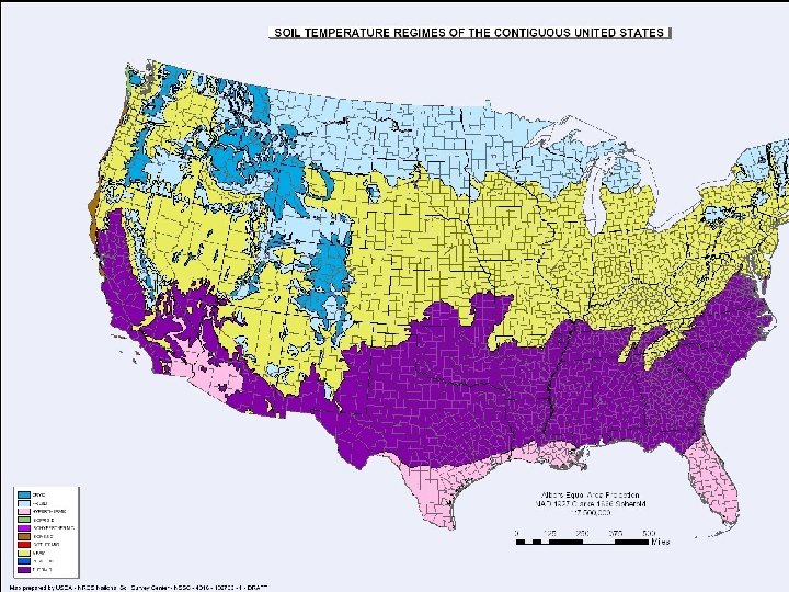
Soil temperature regimes (At 50 cm depth) Permafrost present

http: //soils. usda. gov/use/worldsoils/mapindex/str. jpg
- Slides: 20