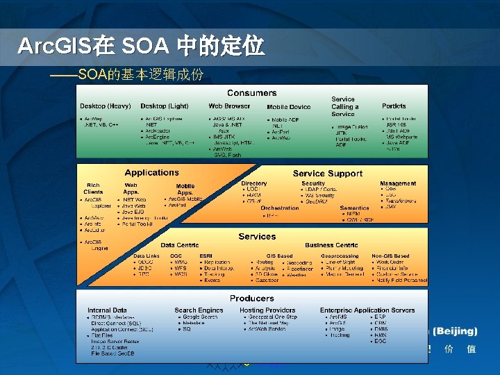
SOA Web Web SOA Web XML SOAP WSDL

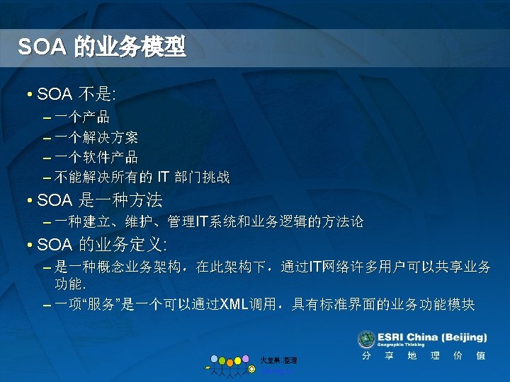
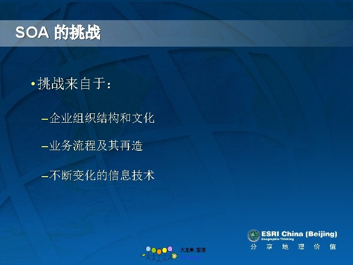

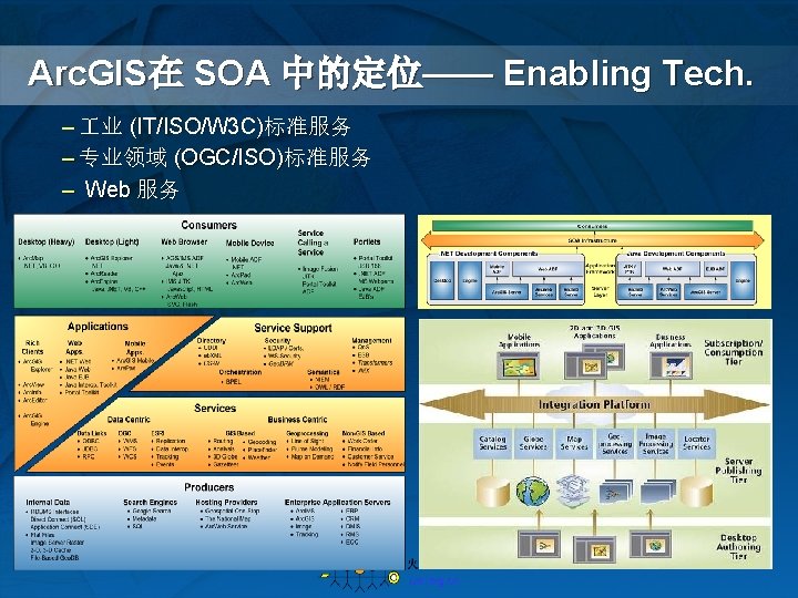
SOA 和 Web 服务 —— Web 服务是 SOA 的关键促成者 • Web 服务 – 技术、产品和中间件无关 技术、产品和中间 – 采用 XML, SOAP, WSDL, UDDI 以 及 Web 服务扩充标准 • 基于 Web 服务的SOA UDDI Enables discovery of Binds to WSDL – 基于Web服务标准 – 提供互操作性 interoperability Is accessed using SOAP Enables Communication between Describes – 支持企业内部以及跨企业之间的集成 Web 服务

GIS标准和互操作性 GIS Standards and Interoperability

主要及次要的标准机构 • 主要国�机构 – OGC – Open Geo-spatial Consortium – ISO - TC 211 – Geographic information/Geomatics • 次�国�机构 – W 3 C – OASIS • 国家�准 – GB XXX(China) – ANSI (US) – Japan

GIS标准化涉及的范畴 • Basic Geographic Structure – ISO 19107 – Spatial Schema, – ISO 19111 – Coordinate Reference Systems • Content Description – ISO 19110 – Feature Catalog Methodology , UML, FGDC Metadata, – ISO 19115 – Metadata • Data Management – OGC Simple Features • Format – VPF, OGC GML, ISO 19139, 80+ industry and national formats • Visualization – SLD, MIL-STD 2525 • Web Services – OGC WMS, WFS, WCS, Open. LS – Registry and catalog services • CAT 1. 0, OAI-PMH, CS-W (eb. RIM)

ESRI对标准和互操作性的支持 �准 • Data Management – Simple Features – Metadata Standards – ISO 19115, 19119, 19139, … • Data Formats – GML, Mid/Mif, Tab, DWG, DGN • Web services Standards – Data and Presentation Services • WMS, WFS, WCS, Open. LS – Registry and Catalog Services • CAT 1. 0, OAI-PMH, CS-W �品 • Provider Level Support – Arc. IMS + Data Delivery Extension – Arc. Engine – Arc. GIS Server – Portal Toolkit • Consumer Level Support – Arc. Map + Data Interoperability Extension – Portal Toolkit Components – Arc. GIS Explorer – Web. ADF
 – HTTP protocol for publishing and")
OGC Web 服务 • Web Mapping Service (WMS) – HTTP protocol for publishing and query of web based map layers as image data (PNG, GIF, JPEG) • Web Feature Service (WFS) – HTTP protocol for publishing web based map layers as vector data (GML 2. 1. 2 , SF GML, GDB GML, …) • Web Coverage Service (WCS) – HTTP protocol for publishing and query of web based image services – a sort of web based image processing service (Geo. Tiff, HDF-EOS, DTED, NITF, GML) • Catalog Services – Web (CS-W) – Defines several web interfaces for data discovery

Arc. GIS 对标准的支持 … … • Data Format – GML, Mid/Mif, Tab, DWG, DGN, KML, … • Supported in Arc. GIS • Supported using Data Interoperability Extension in Arc. Map and Arc. GIS Server • Supported using Data Delivery Extension for Arc. IMS • Data Management – Simple Features Support • All Arc. GIS data models utilize the Simple Feature Specifcations • OGC SFSQL-Types and Functions, and SFSQL Binary schemas supported in the various Arc. GIS database implementations – Metadata Support • Metadata management supported within Arc. Catalog • Support for FGDC, ISO (19115, 19119, 19139) • Metadata Translators available as part of Geoprocessing Tools

Arc. GIS 对标准的支持 … … • Web Services Support – Image Services • Web map services • Supported in Server and Client – Data Services • Feature Service ( OGC Web Feature Service) • Coverage Service ( OGC Web Coverage service) • Supported in Server and Client – Catalog Service • Z 39. 50 protocol • OGC Catalog Services Web Support (CSW 2. 0) – Supports Dublin Core, ISO and eb. RIM profiles. • Harvesting protocol support – OAI PMH • Supported in server and client applications

服务器对Web服务标准的支持 • Arc. IMS • Support for WMS, WFS, CSW • Also additionally supports Filter Encoding and Style Layer Descriptor specification • Arc. GIS Server • • • Support for WMS Additional Support for Style layer Descriptors ( SLD) Support for WFS with OGC Filter Support for WCS Enhanced Support for GML including Export / Import for Geodatabase GML

客户端对Web服务的支持 • Arc. Map – WMS, WFS, GML, WCS, WMC • Data Interoperability Extension – WFS, GML • Arc. Globe/Arc. GIS Explorer – WMS – CSW • Web. ADF – WMS – CS-W • Portal Toolkit Mapviewer – WMS, WFS, WCS
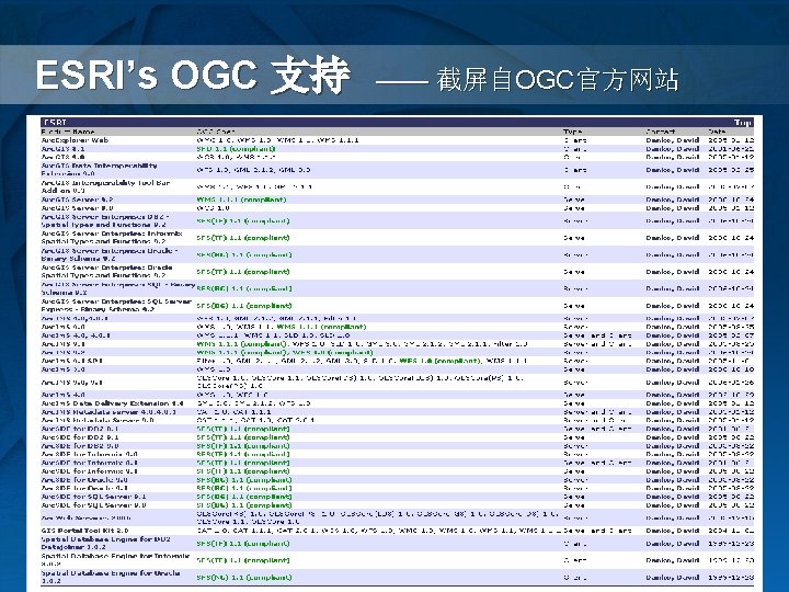

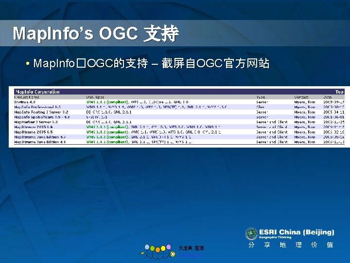
Intergraph’s OGC 支持 • Inergraph�OGC的支持 – 截屏自OGC官方网站

Smallworld’s OGC 支持 • Smallworld�OGC的支持 – 截屏自OGC官方网站
- Slides: 32