SO 442 the MaddenJulian Oscillation Lesson 6 What
- Slides: 32

SO 442 – the Madden-Julian Oscillation Lesson 6

What is the MJO? • Large-scale disturbance of deep convection and winds that controls up to half of the variance of tropical convection in some regions • Now known to be a major propagator of weather systems

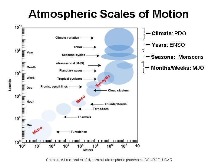
Atmospheric Scales of Motion Climate: PDO Years: ENSO Seasons: Monsoons Months/Weeks: MJO Space and time-scales of dynamical atmospheric processes. SOURCE: UCAR

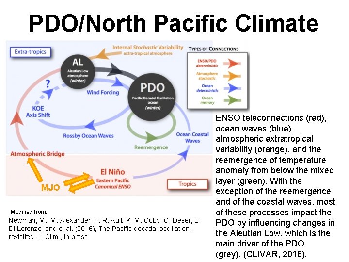
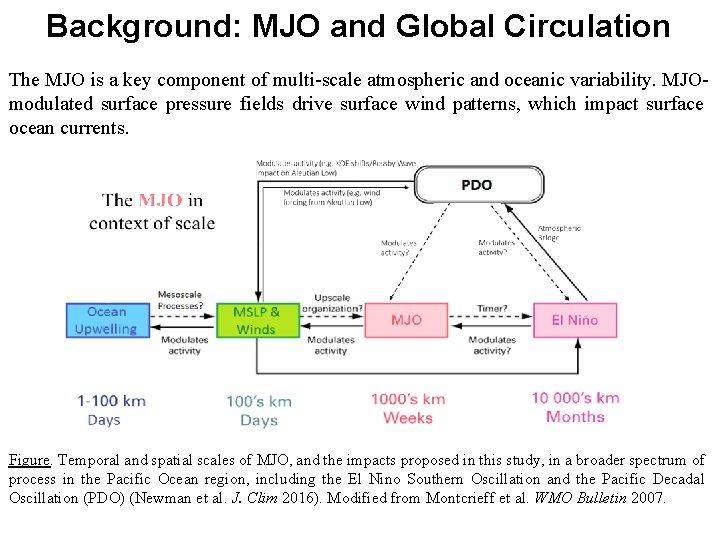
PDO/North Pacific Climate MJO Modified from: Newman, M. Alexander, T. R. Ault, K. M. Cobb, C. Deser, E. Di Lorenzo, and e. al. (2016), The Pacific decadal oscillation, revisited, J. Clim. , in press. ENSO teleconnections (red), ocean waves (blue), atmospheric extratropical variability (orange), and the reemergence of temperature anomaly from below the mixed layer (green). With the exception of the reemergence and of the coastal waves, most of these processes impact the PDO by influencing changes in the Aleutian Low, which is the main driver of the PDO (grey). (CLIVAR, 2016).

MJO- an intraseasonal event • Prior to 1971, it was thought that virtually all variability in the weather conditions within a given season in the Tropics was random. • There were indications of interseasonal variations, such as the Southern Oscillation • Studies of Tropical rainfall and pressure changes showed additional oscillations

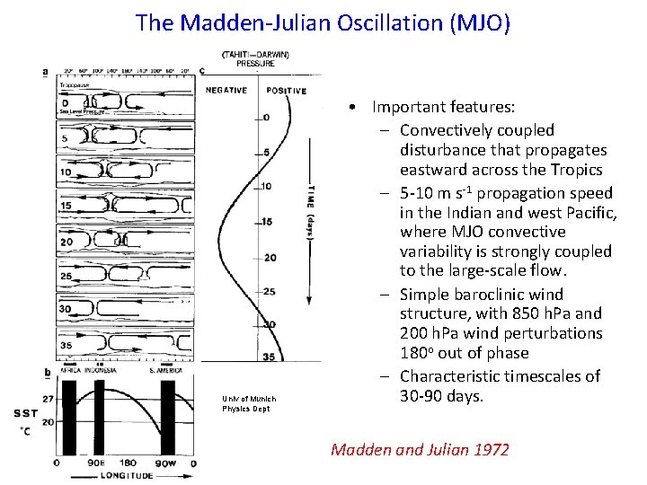
The Madden-Julian Oscillation (MJO) Univ of Munich Physics Dept • Important features: – Convectively coupled disturbance that propagates eastward across the Tropics – 5 -10 m s-1 propagation speed in the Indian and west Pacific, where MJO convective variability is strongly coupled to the large-scale flow. – Simple baroclinic wind structure, with 850 h. Pa and 200 h. Pa wind perturbations 180 o out of phase – Characteristic timescales of 30 -90 days. Madden and Julian 1972

The MJO - A Description • A 30 -60 day oscillation in the coupled Tropical ocean-atmosphere system • An eastward progression of enhanced and suppressed convection • Low level and upper level wind patterns show distinct anomalies • Strong year to year variability in MJO that is related to ENSO cycle

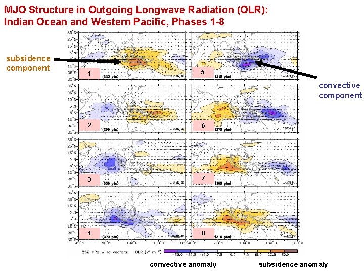
MJO Structure in Outgoing Longwave Radiation (OLR): Indian Ocean and Western Pacific, Phases 1 -8 subsidence component 1 5 convective component 2 6 3 7 4 8 convective anomaly subsidence anomaly

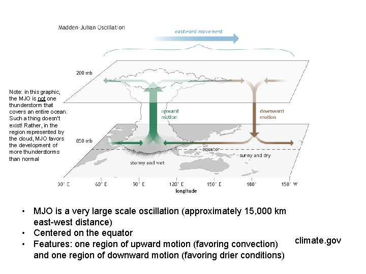
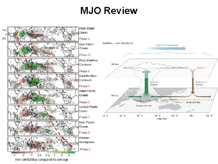
Note: in this graphic, the MJO is not one thunderstorm that covers an entire ocean. Such a thing doesn’t exist! Rather, in the region represented by the cloud, MJO favors the development of more thunderstorms than normal • MJO is a very large scale oscillation (approximately 15, 000 km east-west distance) • Centered on the equator climate. gov • Features: one region of upward motion (favoring convection) and one region of downward motion (favoring drier conditions)

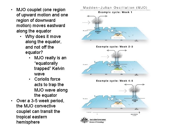
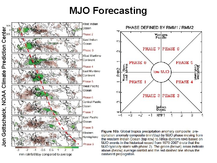
• MJO couplet (one region of upward motion and one region of downward motion) moves eastward along the equator • Why does it move along the equator, and not off the equator? • MJO really is an “equatorally trapped” Kelvin wave • Coriolis force acts to trap the MJO wave along the equator • Over a 3 -5 week period, the MJO convective couplet can transit the tropical eastern hemisphere

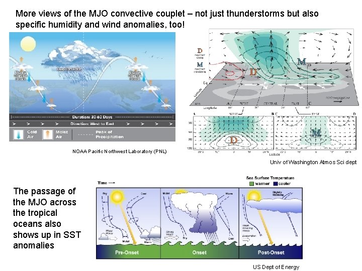
More views of the MJO convective couplet – not just thunderstorms but also specific humidity and wind anomalies, too! NOAA Pacific Northwest Laboratory (PNL) Univ of Washington Atmos Sci dept The passage of the MJO across the tropical oceans also shows up in SST anomalies US Dept of Energy

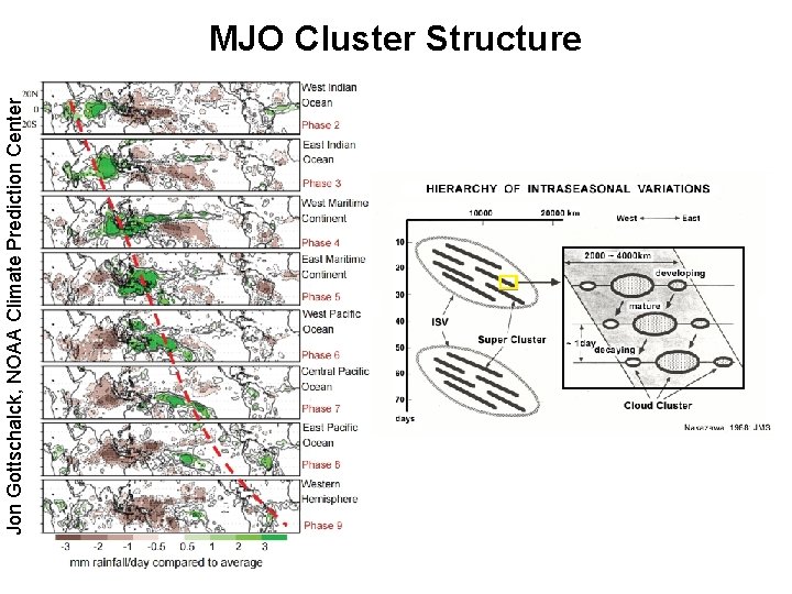
Jon Gottschalck, NOAA Climate Prediction Center MJO Cluster Structure

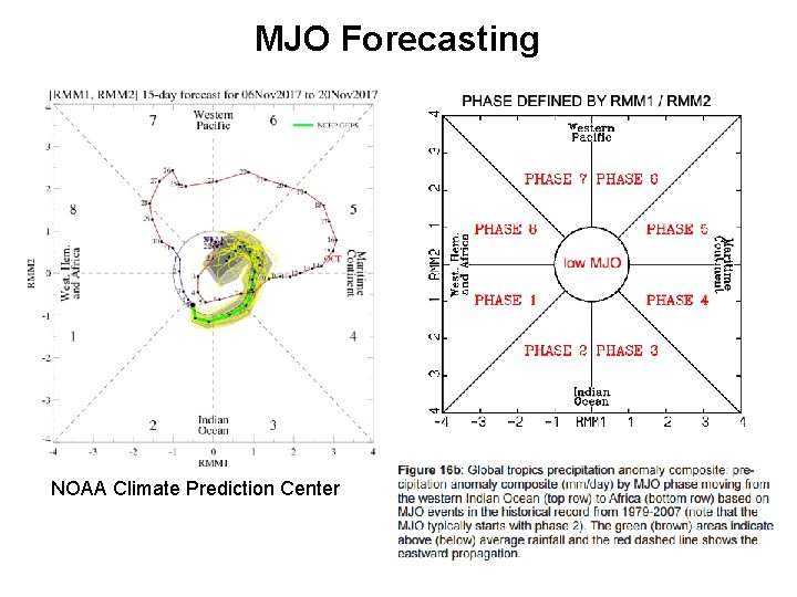
Jon Gottschalck, NOAA Climate Prediction Center MJO Forecasting

MJO Forecasting NOAA Climate Prediction Center

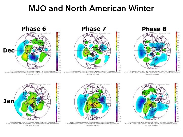
MJO and North American Winter

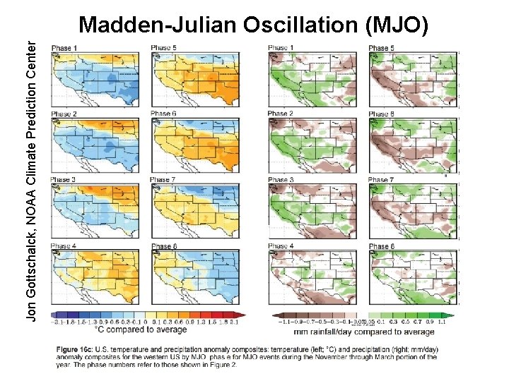
Jon Gottschalck, NOAA Climate Prediction Center Madden-Julian Oscillation (MJO)

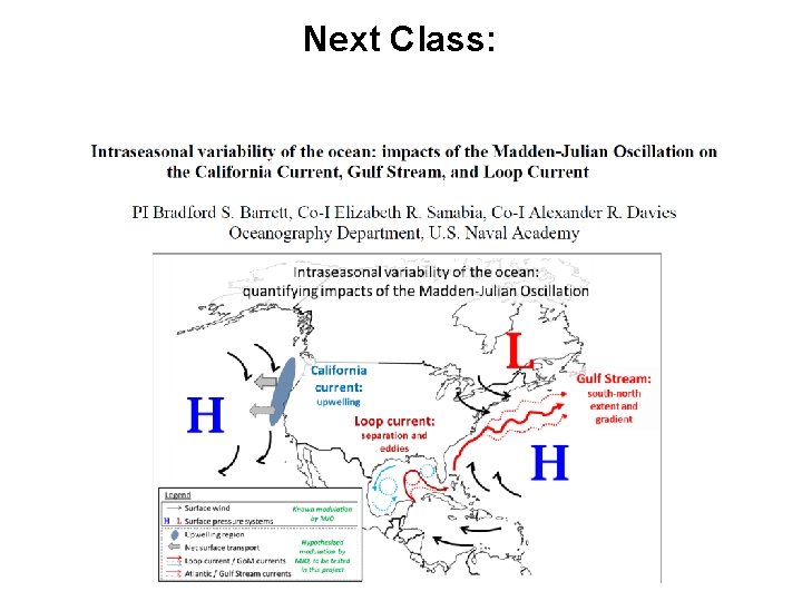
Next Class:


MJO Review

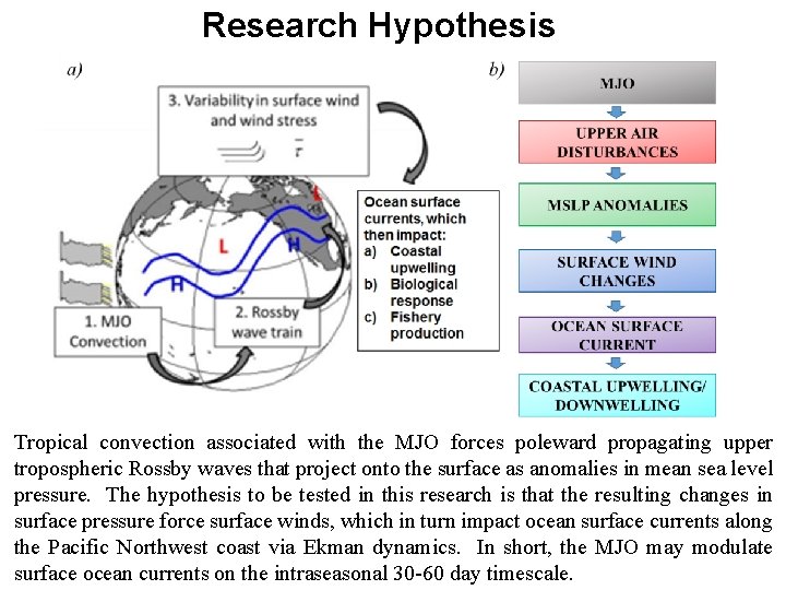
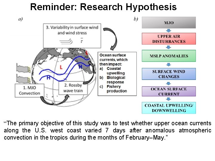
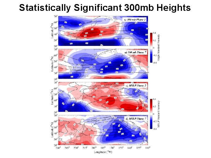
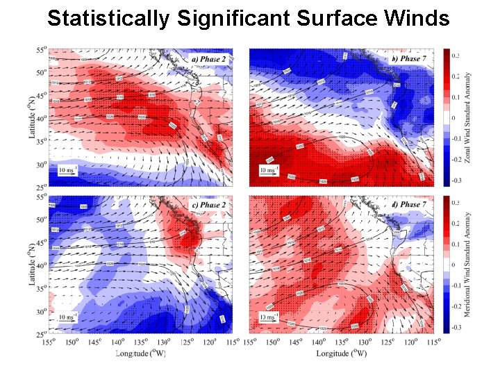
Research Hypothesis Tropical convection associated with the MJO forces poleward propagating upper tropospheric Rossby waves that project onto the surface as anomalies in mean sea level pressure. The hypothesis to be tested in this research is that the resulting changes in surface pressure force surface winds, which in turn impact ocean surface currents along the Pacific Northwest coast via Ekman dynamics. In short, the MJO may modulate surface ocean currents on the intraseasonal 30 -60 day timescale.

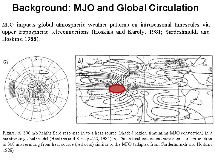
Background: MJO and Global Circulation MJO impacts global atmospheric weather patterns on intraseasonal timescales via upper tropospheric teleconnections (Hoskins and Karoly, 1981; Sardeshmukh and Hoskins, 1988). Figure. a) 300 mb height field response in to a heat source (shaded region simulating MJO convection) in a barotropic global model (Hoskins and Karoly JAS, 1981). b) Theoretical equivalent barotropic streamfunction at 300 mb resulting from heat source (red oval) similar to the MJO (adapted from Sardeshmukh and Hoskins 1988).

Background: MJO and Global Circulation The MJO is a key component of multi-scale atmospheric and oceanic variability. MJOmodulated surface pressure fields drive surface wind patterns, which impact surface ocean currents. Figure. Temporal and spatial scales of MJO, and the impacts proposed in this study, in a broader spectrum of process in the Pacific Ocean region, including the El Nino Southern Oscillation and the Pacific Decadal Oscillation (PDO) (Newman et al. J. Clim 2016). Modified from Montcrieff et al. WMO Bulletin 2007.

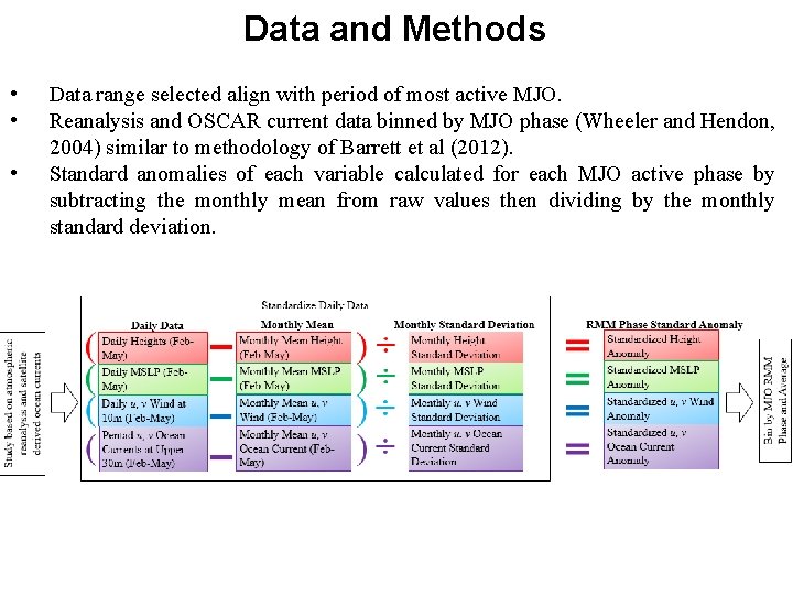
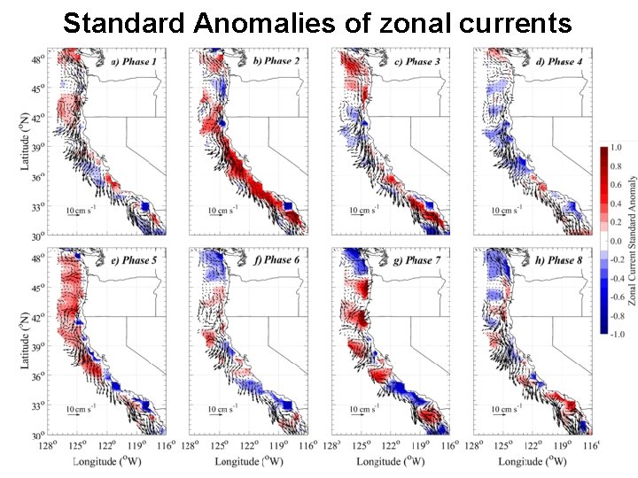
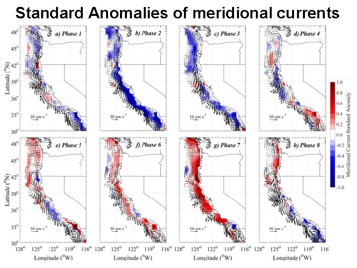
Data and Methods • • • Data range selected align with period of most active MJO. Reanalysis and OSCAR current data binned by MJO phase (Wheeler and Hendon, 2004) similar to methodology of Barrett et al (2012). Standard anomalies of each variable calculated for each MJO active phase by subtracting the monthly mean from raw values then dividing by the monthly standard deviation.

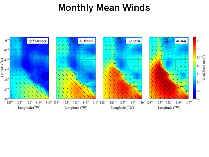
Monthly Mean Winds

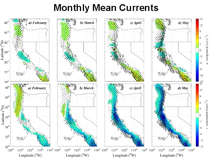
Monthly Mean Currents

Standard Anomalies of zonal currents

Standard Anomalies of meridional currents

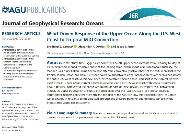
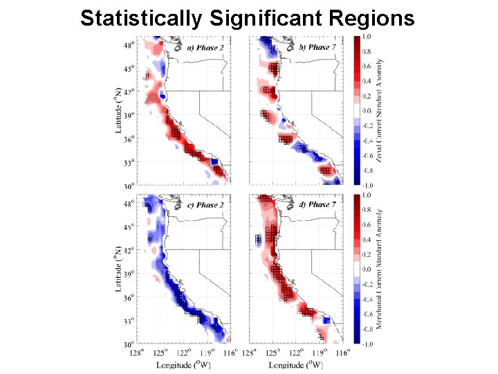
Reminder: Research Hypothesis “The primary objective of this study was to test whether upper ocean currents along the U. S. west coast varied 7 days after anomalous atmospheric convection in the tropics during the months of February–May. ”

Statistically Significant 300 mb Heights

Statistically Significant Surface Winds

Statistically Significant Regions

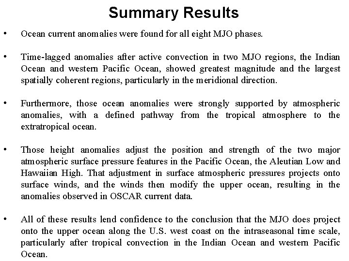
Summary Results • Ocean current anomalies were found for all eight MJO phases. • Time-lagged anomalies after active convection in two MJO regions, the Indian Ocean and western Pacific Ocean, showed greatest magnitude and the largest spatially coherent regions, particularly in the meridional direction. • Furthermore, those ocean anomalies were strongly supported by atmospheric anomalies, with a defined pathway from the tropical atmosphere to the extratropical ocean. • Those height anomalies adjust the position and strength of the two major atmospheric surface pressure features in the Pacific Ocean, the Aleutian Low and Hawaiian High. That adjustment in surface atmospheric pressures projects onto surface winds, and the winds then modify the upper ocean, resulting in the anomalies observed in OSCAR current data. • All of these results lend confidence to the conclusion that the MJO does project onto the upper ocean along the U. S. west coast on the intraseasonal time scale, particularly after tropical convection in the Indian Ocean and western Pacific Ocean.